REVIEW 3 major objections 5 minor 12 references
From Pixels to Planes: Minimum Ground Sample Distance for Aircraft
T0 review · 3 major / 5 minor · reviewed 2026-08-12 · deepseek-v4-flash
Pith's one-line read This paper tries to establish the coarsest satellite-image resolution, roughly 0.86m ground sample distance, at which a modern object detector can still reliably find aircraft of varying sizes, and argues this number should guide camera…
desk verdict Useful engineering rule-of-thumb for camera selection, but the 0.86 m threshold rests on a single model and an unfaithful resampling simulation, so it is provisional until validated. read the letter →
The pith
A machine-rendered reading of the paper's core claim, the machinery that carries it, and where it could break.
The reading
What carries the argument
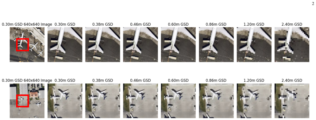
The central mechanism is the resolution ablation: 0.3m GSD source images are downsampled with nearest-neighbor interpolation to 512, 416, 320, 224, 160, and 80 pixels, corresponding to 0.38, 0.46, 0.60, 0.86, 1.2, and 2.4 meters GSD, and a YOLOv8s detector is trained and evaluated at each setting. mAP50-95, grouped by wingspan bins, is the yardstick; the 224-pixel (0.86m) level is where small-aircraft performance holds rather than drops, so it becomes the recommended minimum.
What would settle it
Retrain and evaluate the same detector on natively collected satellite imagery at approximately 1.2m and 0.86m GSD, rather than downsampled 0.3m imagery, and compare mAP50-95: if the 1.2m native imagery does not show a clear small-aircraft accuracy drop, the 0.86m minimum is an artifact of the simulation.
Extended reading notes
Core claim
On the paper's own terms, the discovery is a resolution threshold for aircraft detection in overhead imagery: a ground sample distance of at least 0.86 meters is required to reliably detect most aircraft, and the requirement is set by aircraft with wingspans shorter than 20 meters. The authors arrive at this by training YOLOv8s on versions of the AllPlanes 120 dataset downsampled with nearest-neighbor interpolation to simulate GSDs between 0.38 and 2.4 meters, then measuring mAP50-95 overall and binned by wingspan. Smaller aircraft show a pronounced accuracy drop by 1.2m GSD, making 0.86m the coarsest setting at which their detection remains acceptable. Error analysis attributes the loss mostly to missed detections and misclassifications.
Load-bearing premise
The result assumes that taking a 0.3m image and shrinking it with nearest-neighbor interpolation reproduces what a real camera with coarser ground sample distance would see; if real coarse-GSD imagery carries extra blur, noise, or atmospheric degradation, the 0.86m threshold could shift.
Editorial extensions
If this is right
- At 1.2m GSD and coarser, aircraft with wingspans under 20 meters should be expected to lose substantial mAP50-95.
- A camera system designed for 0.86m GSD can be lighter than one designed for 0.3m GSD while still supporting small-aircraft detection.
- Resolution finer than 0.86m yields only marginal gains for most aircraft classes, so extra weight and bandwidth spent on finer GSD may not pay off.
- Wingspan can serve as a prior for choosing acquisition resolution: missions expecting only large aircraft can tolerate a coarser GSD than missions that must find small planes.
Reading between the lines
- A direct implication the paper leaves implicit: because the simulation uses nearest-neighbor downsampling without sensor blur, noise, or atmospheric effects, the 0.86m figure is likely optimistic for real nadir sensors; real coarse-GSD imagery will probably need a finer nominal GSD, so designers should treat 0.86m as an ideal-condition lower bound.
- The same ablation could be rerun with other detectors, such as oriented bounding boxes or transformer-based models, and the exact threshold would probably shift with model capacity and training data.
- For payload designers, 0.86m converts directly into an optics-and-altitude trade: at higher altitudes the aperture must grow to hold 0.86m GSD, so the result implies a minimum optics size for small-plane detection.
- A testable extension is to use wingspan bins as a resolution prior: a sensor that adaptively zooms to maintain 0.86m only when small aircraft are expected could reduce bandwidth without losing detections.
Editorial analysis
A structured set of objections, weighed in public.
Referee Report
Summary. The paper investigates how ground sample distance (GSD) affects the detection performance of a YOLOv8s detector on the proprietary AllPlanes 120 dataset, which contains 8,123 satellite images and 46,459 labeled aircraft instances across 120 classes. The authors simulate GSD values from 2.4 m to 0.3 m by nearest-neighbor down-sampling of the original 640x640, 0.3 m GSD imagery to sizes from 80x80 to 512x512 pixels, train YOLOv8s at each resolution, and report mAP50-95 binned by wingspan. They conclude that a GSD of at least 0.86 m is required to accurately detect most aircraft, particularly those with wingspans shorter than 20 meters, and they recommend this as a camera-design specification for lightweight high-altitude platforms. The paper includes per-class mAP curves and a TIDE error analysis, but the central threshold rests on a single model, a single proprietary dataset, and a down-sampling scheme that may not represent native coarse-GSD imagery.
Significance. The practical question—what is the minimum GSD needed for reliable aircraft detection—is relevant to camera and payload design, and the paper provides a useful structure by grouping aircraft into wingspan bins and decomposing error types. If the 0.86 m figure were validated against physically faithful coarse-GSD simulation or real coarse-GSD data, it could directly inform sensor selection for high-altitude reconnaissance platforms. The paper is transparent about its proprietary dataset and reports the YOLOv8s training configuration, but the absence of code, data, multiple runs, and error bars makes the central numeric claim non-reproducible. The main contribution is therefore an empirical observation that needs strengthening before it can serve as a design specification.
major comments (3)
- [III.A, Fig. 1] The simulation step equates native coarse GSD with nearest-neighbor decimation. A real sensor at 0.86 m GSD integrates radiance over a ground footprint, applies a modulation transfer function, and adds sensor noise, atmospheric scattering, and motion blur; nearest-neighbor resampling instead selects one pixel per block and preserves high-frequency content, so aircraft spanning only a few pixels can appear or disappear depending on sub-pixel alignment. Because the paper's conclusion is a camera-design specification, this proxy is load-bearing. I request validation with area-averaging (or PSF/MTF) resampling plus noise, and/or real coarse-GSD imagery; the Limitations section (V.C) should acknowledge this proxy explicitly.
- [IV.A, Fig. 2] The 0.86 m threshold is a post-hoc visual inflection point on mAP curves from a single model run on one dataset. There are no error bars, no multiple seeds, no statistical test, and no pre-specified criterion for what 'accurately detect' means. The differences between adjacent resolution bins in Figure 2 are not quantified; without confidence intervals, the point estimate 0.86 m cannot support a design specification. Please provide multiple runs, confidence intervals, and a transparent threshold rule.
- [II and III.B] No train/validation/test split is described for the AllPlanes 120 dataset, and it is not stated whether the reported mAP values are computed on images used in training. Since all resolutions are derived from the same 0.3 m images, this distinction is essential; the reported numbers are otherwise not interpretable and the experiment is not reproducible. Please specify the split, the number of images per class, and the exact evaluation protocol (e.g., COCO-style mAP parameters).
minor comments (5)
- [Abstract and IV.A] The word 'aircrafts' is used where 'aircraft' (as the plural) is standard; please correct it in the Abstract and in Section IV.A.
- [References, [7]] Reference [7] has a malformed, duplicated URL ('ultralytics/ultralyticshttps://github.com/ultralytics/ultralytics/issues/...'); please fix the citation or replace it with the canonical GitHub issue link.
- [III.A] The statement that 'the 4 keypoints were converted into a horizontal bounding box' is unclear; please define what the keypoints are and how the bounding box is derived from them.
- [Figures 2-4] The axis labels and legend text in Figures 2-4 are too small to read at the supplied resolution; please enlarge them or provide higher-resolution versions.
- [V.C] The Limitations section mentions model choice and environmental factors but does not mention the nearest-neighbor interpolation proxy; adding that limitation would give readers a more accurate picture of the claim's scope.
Circularity Check
No significant circularity: the 0.86m GSD conclusion is an empirical summary of the paper's own mAP experiments, not a derivation from or definition in terms of its inputs.
full rationale
The paper does not claim to derive the 0.86m figure from a theory or from a fitted parameter; it reports an empirical summary of its own experiments. The threshold is read post hoc from the mAP curves in Figure 2, and the value 0.86m is simply the label assigned to the 224x224 downsampled condition in Section III.A. That is data summarization, not a definitional loop: the mAP measurements are not defined in terms of the conclusion, and the conclusion is not a fitted quantity that is then relabeled as a prediction. The two self-citations ([8] and [11]) appear in non-load-bearing future-work and limitations contexts, and no load-bearing argument reduces to a self-citation. The nearest-neighbor downsampling proxy for simulating coarser GSD is a threat to external validity, because real coarse-GSD sensors suffer additional blur, noise, and atmospheric effects that are absent here, but that is a correctness or validation concern rather than a circularity concern. No equation is shown to reduce to another by construction, and no uniqueness theorem or ansatz is imported from prior work by the same authors. The paper's central claim is therefore self-contained as an empirical finding, even though its generalizability to real sensors remains unvalidated.
Assumptions & free parameters
free parameters (2)
- Minimum GSD threshold =
0.86 m
- Wingspan bin widths =
10 m bins (0-10, 10-20, ..., 70-80)
assumptions (4)
- domain assumption Nearest-neighbor down-sampling of 0.3m GSD imagery faithfully approximates detection performance at coarser GSDs.
- domain assumption The YOLOv8s detector trained at each resolution is a representative detector for that GSD.
- domain assumption The AllPlanes 120 dataset is representative of real-world aircraft imagery and annotations.
- domain assumption Wingspan is a sufficient proxy for aircraft detectability across resolutions.
Cite this review
Pith. "Pith review of From Pixels to Planes: Minimum Ground Sample Distance for Aircraft." pith.science (2026). https://pith.science/paper/JVT2I5ZY
@misc{pith2026241202137,
  author       = {Pith},
  title        = {Pith review of: From Pixels to Planes: Minimum Ground Sample Distance for Aircraft},
  year         = {2026},
  howpublished = {\url{https://pith.science/paper/JVT2I5ZY}},
  note         = {Machine review of arXiv:2412.02137}
}
read the original abstract
This study investigates the impact of ground sample distance (GSD) on the detection performance of various sized aircraft using the proprietary AllPlanes 120 dataset. The data set comprises 120 civilian, military and museum aircraft from multiple satellite/aerial sources collected over two years. Resolutions ranging from 2.4 to 0.3 meters GSD were simulated. Performance metrics were derived from a YOLOv8s model trained on down-sampled versions of zoom level 19 (0.3m GSD) imagery. The results indicate that a GSD of at least 0.86m is required to accurately detect most aircraft, particularly those with wingspans shorter than 20 meters. Due to weight constraints in high-altitude platforms, this GSD specification can inform camera design to minimize weight while maintaining detection accuracy.
Figures


Reference graph
Works this paper leans on
-
[1]
G. Cheng and J. Han, ``A survey on object detection in optical remote sensing images,'' ISPRS journal of photogrammetry and remote sensing, vol. 117, pp. 11--28, 2016
work page 2016
-
[2]
Available: https://www.google.com/maps/
``Google maps.'' [Online]. Available: https://www.google.com/maps/
-
[3]
Available: https://www.bing.com/maps
``Bing maps.'' [Online]. Available: https://www.bing.com/maps
-
[4]
Available: https://www.mapbox.com/
``Mapbox.'' [Online]. Available: https://www.mapbox.com/
- [5]
- [6]
-
[7]
Jocher, ``Ultralytics yolov8 losses,'' 2024
G. Jocher, ``Ultralytics yolov8 losses,'' 2024. [Online]. Available: https://github.com/ultralytics/ultralyticshttps://github.com/ultralytics/ultralytics/issues/10375#issuecomment-2144034899
work page 2024
-
[8]
M. Ciolino, D. Noever, and J. Kalin, ``Training set effect on super resolution for automated target recognition,'' in Automatic Target Recognition XXX, vol. 11394. 1em plus 0.5em minus 0.4em SPIE, 2020, pp. 105--117
work page 2020
Show all 12 references
-
[9]
C. Dong, C. C. Loy, K. He, and X. Tang, ``Image super-resolution using deep convolutional networks,'' IEEE transactions on pattern analysis and machine intelligence, vol. 38, no. 2, pp. 295--307, 2015
2015
-
[10]
Y. Wang, S. M. A. Bashir, M. Khan, Q. Ullah, R. Wang, Y. Song, Z. Guo, and Y. Niu, ``Remote sensing image super-resolution and object detection: Benchmark and state of the art,'' Expert Systems with Applications, vol. 197, p. 116793, 2022
2022
-
[11]
Ciolino, D
M. Ciolino, D. Hambrick, and D. Noever, ``Enhancing satellite imagery using deep learning for the sensor to shooter timeline,'' arXiv preprint arXiv:2203.00116, 2022
2022 arXiv
-
[12]
write newline
" write newline "" initialize.prev.this.status FUNCTION begin.bib " write newline preamble empty 'skip preamble write newline if " thebibliography " longest.label * " " * write newline " [1] #1 " write newline " url@samestyle " write newline " " write newline " [2] #2 " write ...
Reviewed August 12, 2026 · model on record in the stance chip above.
Discussion (0). Continue with ORCID to comment.