REVIEW 4 major objections 5 minor 1 cited by
Sat-DN: Implicit Surface Reconstruction from Multi-View Satellite Images with Depth and Normal Supervision
T0 review · 4 major / 5 minor · reviewed 2026-08-08 · deepseek-v4-flash
Pith's one-line read The paper claims that adding depth and normal supervision to a hash-grid neural surface field makes satellite 3D reconstruction more accurate and faster than existing methods.
desk verdict Competent engineering, plausible gains, but the SOTA claim leans on a depth prior that is validated only indirectly and does not hold on every scene. read the letter →
The pith
A machine-rendered reading of the paper's core claim, the machinery that carries it, and where it could break.
The reading
What carries the argument
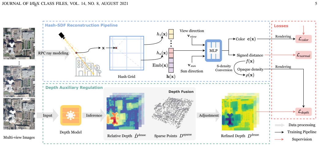
The central object is a multi-resolution hash-grid-encoded signed distance field with a NeuS-style unbiased density conversion, which lets the reconstructed surface be extracted as the zero level set or rendered as a DSM. The load-bearing mechanism is the depth supervision: monocular relative depth is affine-fitted to sparse bundle-adjusted points to obtain dense real-scale depth, and an L1 loss on rendered depth anchors the SDF geometry despite strong photometric variation. Two supporting mechanisms are the normal angular-consistency loss, which smooths planar regions by matching neighbor-to-neighbor normal angle differences rather than absolute normals (bypassing the coordinate-system mismatch between image depth and UTM-space SDF gradients), and the progressive grid activation, which gates high-resolution hash levels behind low-resolution ones to avoid holes and indentations on building facades.
What would settle it
Using the paper's own Fig. 10 depth-fusion residuals, one could test whether per-scene reconstruction error tracks per-scene depth-fit error: if a scene with near-zero least-squares fusion error still shows high MAE or CD, or a scene with large fusion error still shows low MAE or CD, then the depth prior is not the dominant source of the reported gains and the central claim would be weakened.
Extended reading notes
Core claim
Sat-DN builds on the NeuS formulation, which converts a signed distance function into an opaque density so that volume rendering's zero level set coincides with the surface, and replaces the slow MLP scene representation with a multi-resolution hash grid. Rays are modeled through the satellite RPC camera model, and a pre-trained monocular depth model predicts relative depth for each image. The relative depth is rescaled by a least-squares fit to sparse 3D points obtained from triangulation and bundle adjustment, yielding a dense absolute-scale depth map that supervises the rendered depth per pixel, with water regions masked out. A normal angular-consistency loss compares the angular difference between neighboring rendered normals and neighboring normals computed from the depth map, encouraging planar regions such as rooftops and roads to stay flat. A progressive training schedule activates coarse grid levels before fine ones, and the paper reports that this combination outperforms S2P, VisSat, S-NeRF, Sat-NeRF, and FVMD-ISRe on most DFC2019 scenes in both DSM and mesh accuracy, while training faster and using less memory than the neural baselines.
Load-bearing premise
The method assumes that a depth model trained on ordinary ground-level photos produces relative depth estimates on satellite imagery that, after an affine fit to sparse bundle-adjusted points, are accurate enough to guide the SDF geometry.
Editorial extensions
If this is right
- If the central claim holds, neural implicit surface reconstruction from satellite images becomes practical on a single consumer GPU, with per-scene training around 5.6 hours instead of 8-10 hours for earlier NeRF baselines.
- Depth and normal priors can compensate for the missing multi-view cues in weakly textured and multi-temporal satellite scenes, reducing the need for dense stereo matching or manual view selection.
- The same trained field yields both a digital surface model and a watertight mesh, so downstream users can choose either product without retraining.
- The reported ablation implies that the accuracy gain is cumulative: progressive training alone helps, depth regularization helps more, and normal consistency adds the final planar sharpness.
- Because the method masks water and struggles with vegetation, satellite-specific depth priors or semantic-aware losses would be a direct next step to extend coverage to non-urban terrain.
Reading between the lines
- A natural extension the paper does not test is replacing the monocular depth model with one fine-tuned on satellite imagery; if the affine fit is absorbing systematic bias correctly, such fine-tuning could improve accuracy on water and vegetation where the current prior fails.
- The normal consistency loss only constrains angular differences between neighboring pixels, so a global tilt or systematic rotation of the surface normals would go undetected; an absolute normal loss in a common coordinate frame, if it could be obtained, would be a stronger constraint.
- The evaluation is limited to 256-meter tiles; scaling to city-wide reconstruction would require handling depth-fit drift across tiles and variable cloud or shadow conditions, which the paper does not address.
- The method's reliance on a semantic water mask means its benefits in unmasked scenes are uncertain; an automatic mask or learned robustness to bad depth regions would be needed for fully automatic operation.
Editorial analysis
A structured set of objections, weighed in public.
Referee Report
Summary. Sat-DN proposes a neural implicit surface reconstruction pipeline for multi-view satellite images. It combines a multi-resolution hash grid with NeuS-style SDF rendering, a progressive coarse-to-fine activation schedule, and two geometric regularizers: an L1 depth loss against dense depth obtained by affine-fitting Depth Anything V2 relative depth to sparse bundle-adjusted 3D points, and a normal angular-consistency loss computed from depth-derived and SDF-derived normals. Experiments on five Jacksonville and five Omaha scenes from DFC2019 report MAE, MED, Chamfer distance, training time, and memory usage, plus ablations on JAX 068. The central claim is state-of-the-art DSM and mesh reconstruction accuracy and faster training than neural baselines.
Significance. The method addresses a real bottleneck: satellite surface reconstruction suffers from multi-temporal illumination and weak texture, and NeRF baselines are slow. The combination of hash-grid acceleration with depth and normal priors is reasonable, and the paper includes a public code release, external LiDAR DSM ground truth, and a component-wise ablation that shows each proposed term contributes to the reported accuracy. If the depth-prior caveats are resolved, the efficiency gain (about 5.6 hours versus 10.2 hours for FVMD-ISRe) and competitive accuracy would be a useful contribution to the satellite photogrammetry community. However, the headline state-of-the-art claim is stronger than the evidence, mainly because the pseudo-depth prior is not directly validated and the ablation is limited to one scene.
major comments (4)
- [§IV-A, Eq. (7), Table V] The dense depth used in Eq. (9) is obtained by fitting a scale and offset of monocular relative depth to sparse bundle-adjusted points. The authors state in §IV-A that the depth model "is not always accurate when applied to satellite images" and fails on water and vegetation, and Table V shows that DepthReg is the single largest contributor on JAX 068 (MAE from 1.599 to 1.127). Yet there is no direct comparison of the fitted dense depth map against the LiDAR DSM before training; Fig. 10 reports only least-squares fitting residuals on the sparse points. The reported improvements could therefore reflect the quality of a per-scene depth prior rather than a generally better reconstruction method. Please add a direct evaluation of D_dense against the LiDAR DSM for all ten scenes, and an ablation on at least one scene where the depth model is known to struggle, such as OMA 203 or JAX 207.
- [Tables II and III] The abstract and §V-D claim state-of-the-art performance, but Table III shows FVMD-ISRe is better on all three metrics in OMA 203 (e.g., MAE 0.798 vs. 0.930) and on two of three metrics in OMA 212 and OMA 248. In JAX 068 the MAE difference is 0.002 m (1.030 vs. 1.032) and MED slightly favors FVMD-ISRe. Without error bars or repeated runs, differences of 0.01-0.03 m cannot be distinguished from noise. The claim should be qualified to "competitive or better on most scenes" or supported with statistical significance tests.
- [Table V and Fig. 8] The ablations are performed only on JAX 068, which appears to be the scene where the depth prior is most reliable (smallest fitting error in Fig. 10). The contribution of each component is therefore not established on scenes with reflective surfaces or vegetation, where the depth prior is acknowledged to fail. Running the same ablation on OMA 203 or JAX 207 would show whether the depth and normal losses help or hurt when the prior is unreliable.
- [§V-C and Tables II-III] Several baselines are not re-run under identical conditions: SpS-NeRF, Sat-Mesh, and NeuS use reported numbers from other papers, so the reader cannot verify that the same image subsets, crops, and evaluation code were used. In Tables II and III, NeuS results are reported with only MAE, making the comparison incomplete. Please either re-run these baselines with the same training budget or clearly state that the comparison is indicative rather than strictly controlled.
minor comments (5)
- [§V-D] The text states that in JAX 175 "our method still produced the second-best results across all evaluation metrics," but Table II shows Sat-DN is best on MAE, MED, and CD for JAX 175; please correct this contradiction.
- [Eq. (16)] There is a typo: "mediam" should be "median."
- [§IV-D] The text says "Both parameters are defined as 0.1" although three weights lambda_1, lambda_2, and lambda_3 are introduced in Eq. (14); please say "All three weights."
- [§IV-A and §V-B] The water mask M in Eq. (9) is mentioned but its source and computation are not described in the implementation details; please clarify how the semantic mask is obtained and applied.
- [Fig. 2 and §IV-B] The pipeline figure and the color MLP description mention the sun direction as an input, but the method overview and ablation do not discuss its role; please explain whether it is used and how, or remove it from the figure.
Circularity Check
No significant circularity: Sat-DN's depth and normal supervision are calibrated to sparse geometric points and evaluated against external LiDAR DSM ground truth.
full rationale
The paper's derivation chain is self-contained and non-circular. The central claim (state-of-the-art on DFC2019) is evaluated by MAE, MED, and Chamfer distance against LiDAR DSMs (Eqs. 15-17) that are never used in the training losses. The auxiliary depth supervision (Eqs. 6-9) fits the scale and offset of monocular relative depth from Depth Anything V2 to sparse bundle-adjusted points, and the rendered depth is penalized against this fitted dense prior; this is a standard calibration step, not a prediction that encodes the evaluation target. The normal angular consistency loss (Eqs. 10-12) is derived from the same depth prior and SDF gradients, and it supervises distributional smoothness, not the LiDAR metric. No load-bearing step reduces to its own input by construction, and the paper does not invoke a uniqueness theorem or other premise justified solely by self-citation; indeed, it contains no self-citations from the authors' prior work. The authors' own caveat that Depth Anything V2 'is not always accurate when applied to satellite images' (Section IV-A) and the ablation showing depth regularization is the largest contributor (Table V) identify a genuine correctness risk in low-texture and reflective scenes such as OMA203-248, but a brittle or inaccurate prior is an empirical weakness, not circular reasoning. The fitted depth prior is external and independently testable, and the final metrics are external, so the derivation does not reduce to its inputs.
Assumptions & free parameters
free parameters (5)
- Depth scale s and offset o =
per scene, via least squares in Eq. 7
- Loss weights lambda1, lambda2, lambda3 =
0.1 each (fixed)
- Progressive training activation schedule =
lambda starts at 4, increases by 1 every 2.5% of training
- Hash grid configuration =
24 levels, resolutions 16 to 2048, hash table 2^19, feature dim 2
- Water mask M =
binary mask per scene
assumptions (6)
- standard math NeuS unbiased density-SDF conversion (Eq. 2) is a valid basis for surface reconstruction.
- domain assumption RPC camera model can be approximated by re-parameterized rays in UTM canonical space between two reference planes.
- domain assumption Depth Anything V2 provides sufficiently accurate relative depth on satellite imagery after affine alignment.
- domain assumption Sparse 3D points from triangulation and bundle adjustment are accurate enough to calibrate the depth prior.
- domain assumption Non-edge pixels lie on planar surfaces, so neighboring normals should be angularly consistent.
- domain assumption Low-frequency geometry should be optimized before high-frequency detail to avoid local optima and holes.
Cite this review
Pith. "Pith review of Sat-DN: Implicit Surface Reconstruction from Multi-View Satellite Images with Depth and Normal Supervision." pith.science (2026). https://pith.science/paper/K56FU5PG
@misc{pith2026250208352,
  author       = {Pith},
  title        = {Pith review of: Sat-DN: Implicit Surface Reconstruction from Multi-View Satellite Images with Depth and Normal Supervision},
  year         = {2026},
  howpublished = {\url{https://pith.science/paper/K56FU5PG}},
  note         = {Machine review of arXiv:2502.08352}
}
read the original abstract
With advancements in satellite imaging technology, acquiring high-resolution multi-view satellite imagery has become increasingly accessible, enabling rapid and location-independent ground model reconstruction. However, traditional stereo matching methods struggle to capture fine details, and while neural radiance fields (NeRFs) achieve high-quality reconstructions, their training time is prohibitively long. Moreover, challenges such as low visibility of building facades, illumination and style differences between pixels, and weakly textured regions in satellite imagery further make it hard to reconstruct reasonable terrain geometry and detailed building facades. To address these issues, we propose Sat-DN, a novel framework leveraging a progressively trained multi-resolution hash grid reconstruction architecture with explicit depth guidance and surface normal consistency constraints to enhance reconstruction quality. The multi-resolution hash grid accelerates training, while the progressive strategy incrementally increases the learning frequency, using coarse low-frequency geometry to guide the reconstruction of fine high-frequency details. The depth and normal constraints ensure a clear building outline and correct planar distribution. Extensive experiments on the DFC2019 dataset demonstrate that Sat-DN outperforms existing methods, achieving state-of-the-art results in both qualitative and quantitative evaluations. The code is available at https://github.com/costune/SatDN.
Figures


Figures from the paper (7 more)


Forward citations
Cited by 1 Pith paper
-
CASA-SDF: Curriculum-Aware Spatial Adaptation with Curvature-Guided Density for Neural Implicit Surface Reconstruction
By combining uncertainty-annealed prior supervision with curvature-adaptive SDF sharpness, CASA-SDF improves completeness and recall in indoor neural surface reconstruction.
Reference graph
Works this paper leans on
-
[1]
A review of 3d reconstruction from high-resolution urban satellite images,
L. Zhao, H. Wang, Y . Zhu, and M. Song, “A review of 3d reconstruction from high-resolution urban satellite images,” International Journal of Remote Sensing , vol. 44, no. 2, pp. 713–748, 2023
work page 2023
-
[2]
Automatic 3d reconstruction from multi-date satellite images,
G. Facciolo, C. De Franchis, and E. Meinhardt-Llopis, “Automatic 3d reconstruction from multi-date satellite images,” in 2017 IEEE Conference on Computer Vision and Pattern Recognition Workshops (CVPRW), 2017, pp. 1542–1551
work page 2017
-
[3]
Urban semantic 3d reconstruction from multiview satellite imagery,
M. J. Leotta, C. Long, B. Jacquet, M. Zins, D. Lipsa, J. Shan, B. Xu, Z. Li, X. Zhang, S.-F. Chang, M. Purri, J. Xue, and K. Dana, “Urban semantic 3d reconstruction from multiview satellite imagery,” in Proceedings of the IEEE/CVF Conference on Computer Vision and Pattern Recognition (CVPR) Workshops , June 2019
work page 2019
-
[4]
Leveraging Vision Reconstruction Pipelines for Satellite Imagery,
K. Zhang, N. Snavely, and J. Sun, “Leveraging Vision Reconstruction Pipelines for Satellite Imagery,” in 2019 IEEE/CVF International Con- ference on Computer Vision Workshop (ICCVW) . IEEE, Oct. 2019, pp. 2139–2148
work page 2019
-
[5]
R. Mar ´ı, G. Facciolo, and T. Ehret, “Sat-NeRF: Learning multi-view satellite photogrammetry with transient objects and shadow modeling using RPC cameras,” in 2022 IEEE/CVF Conference on Computer Vision and Pattern Recognition Workshops (CVPRW) , 2022, pp. 1310–1320
work page 2022
-
[6]
Nerf: Representing scenes as neural radiance fields for view synthesis,
B. Mildenhall, P. P. Srinivasan, M. Tancik, J. T. Barron, R. Ramamoorthi, and R. Ng, “Nerf: Representing scenes as neural radiance fields for view synthesis,” Communications of the ACM , vol. 65, no. 1, pp. 99–106, 2021. JOURNAL OF LATEX CLASS FILES, VOL. 14, NO. 8, AUGUST 2021 16
work page 2021
-
[7]
Mip-nerf: A multiscale representation for anti- aliasing neural radiance fields,
J. T. Barron, B. Mildenhall, M. Tancik, P. Hedman, R. Martin-Brualla, and P. P. Srinivasan, “Mip-nerf: A multiscale representation for anti- aliasing neural radiance fields,” ICCV, 2021
work page 2021
-
[8]
Shadow neural radiance fields for multi-view satellite photogrammetry,
D. Derksen and D. Izzo, “Shadow neural radiance fields for multi-view satellite photogrammetry,” in Proceedings of the IEEE/CVF Conference on Computer Vision and Pattern Recognition , 2021, pp. 1152–1161
work page 2021
Show all 62 references
-
[9]
Multi-date earth observation nerf: The detail is in the shadows,
R. Mar ´ı, G. Facciolo, and T. Ehret, “Multi-date earth observation nerf: The detail is in the shadows,” in Proceedings of the IEEE/CVF Confer- ence on Computer Vision and Pattern Recognition (CVPR) Workshops , June 2023, pp. 2034–2044
2023
-
[10]
Fvmd-isre: 3- d reconstruction from few-view multidate satellite images based on the implicit surface representation of neural radiance fields,
C. Zhang, Y . Yan, C. Zhao, N. Su, and W. Zhou, “Fvmd-isre: 3- d reconstruction from few-view multidate satellite images based on the implicit surface representation of neural radiance fields,” IEEE Transactions on Geoscience and Remote Sensing , vol. 62, pp. 1–14, 2024
2024
-
[11]
Structure-from-motion revisited,
J. L. Sch ¨onberger and J.-M. Frahm, “Structure-from-motion revisited,” in Conference on Computer Vision and Pattern Recognition (CVPR) , 2016
2016
-
[12]
Neus: Learning neural implicit surfaces by volume rendering for multi-view reconstruction,
P. Wang, L. Liu, Y . Liu, C. Theobalt, T. Komura, and W. Wang, “Neus: Learning neural implicit surfaces by volume rendering for multi-view reconstruction,” arXiv preprint arXiv:2106.10689 , 2021
2021 arXiv
-
[13]
Nerf in the wild: Neural radiance fields for unconstrained photo collections,
R. Martin-Brualla, N. Radwan, M. S. Sajjadi, J. T. Barron, A. Doso- vitskiy, and D. Duckworth, “Nerf in the wild: Neural radiance fields for unconstrained photo collections,” in Proceedings of the IEEE/CVF conference on computer vision and pattern recognition , 2021, pp. 7210– 7219
2021
-
[14]
Urban radiance fields,
K. Rematas, A. Liu, P. P. Srinivasan, J. T. Barron, A. Tagliasacchi, T. Funkhouser, and V . Ferrari, “Urban radiance fields,” inProceedings of the IEEE/CVF Conference on Computer Vision and Pattern Recognition , 2022, pp. 12 932–12 942
2022
-
[15]
Robustnerf: Ignoring distractors with robust losses,
S. Sabour, S. V ora, D. Duckworth, I. Krasin, D. J. Fleet, and A. Tagliasacchi, “Robustnerf: Ignoring distractors with robust losses,” in Proceedings of the IEEE/CVF Conference on Computer Vision and Pattern Recognition (CVPR) , June 2023, pp. 20 626–20 636
2023
-
[16]
Geo-neus: Geometry-consistent neural implicit surfaces learning for multi-view reconstruction,
Q. Fu, Q. Xu, Y .-S. Ong, and W. Tao, “Geo-neus: Geometry-consistent neural implicit surfaces learning for multi-view reconstruction,” Ad- vances in Neural Information Processing Systems (NeurIPS) , 2022
2022
-
[17]
Neus2: Fast learning of neural implicit surfaces for multi-view reconstruction,
Y . Wang, Q. Han, M. Habermann, K. Daniilidis, C. Theobalt, and L. Liu, “Neus2: Fast learning of neural implicit surfaces for multi-view reconstruction,” 2023 IEEE/CVF International Conference on Computer Vision (ICCV), pp. 3272–3283, 2022
2023
-
[18]
Depth-supervised NeRF: Fewer views and faster training for free,
K. Deng, A. Liu, J.-Y . Zhu, and D. Ramanan, “Depth-supervised NeRF: Fewer views and faster training for free,” in Proceedings of the IEEE/CVF Conference on Computer Vision and Pattern Recognition (CVPR), June 2022
2022
-
[19]
Streetsurf: Extending multi-view implicit surface reconstruction to street views,
J. Guo, N. Deng, X. Li, Y . Bai, B. Shi, C. Wang, C. Ding, D. Wang, and Y . Li, “Streetsurf: Extending multi-view implicit surface reconstruction to street views,” arXiv preprint arXiv:2306.04988 , 2023
2023 arXiv
-
[20]
Depth anything v2,
L. Yang, B. Kang, Z. Huang, Z. Zhao, X. Xu, J. Feng, and H. Zhao, “Depth anything v2,” arXiv:2406.09414, 2024
2024 arXiv
-
[21]
Instant neural graphics primitives with a multiresolution hash encoding,
T. M ¨uller, A. Evans, C. Schied, and A. Keller, “Instant neural graphics primitives with a multiresolution hash encoding,” ACM Trans. Graph. , vol. 41, no. 4, pp. 102:1–102:15, Jul. 2022
2022
-
[22]
Data fusion contest 2019 (dfc2019),
B. Le Saux, N. Yokoya, R. H ¨ansch, and M. Brown, “Data fusion contest 2019 (dfc2019),” 2019
2019
-
[23]
Towards large-scale city reconstruction from satellites,
L. Duan and F. Lafarge, “Towards large-scale city reconstruction from satellites,” in ECCV 2016: 14th European Conference, Amsterdam, The Netherlands, October 11-14, 2016, Proceedings, Part V 14 . Springer, 2016, pp. 89–104
2016
-
[24]
Double propagation stereo matching for urban 3-d reconstruction from satellite imagery,
L. Zhao, Y . Liu, C. Men, and Y . Men, “Double propagation stereo matching for urban 3-d reconstruction from satellite imagery,” IEEE Transactions on Geoscience and Remote Sensing , vol. 60, pp. 1–17, 2021
2021
-
[25]
Resdepth: A deep residual prior for 3d reconstruction from high-resolution satellite images,
C. Stucker and K. Schindler, “Resdepth: A deep residual prior for 3d reconstruction from high-resolution satellite images,” ISPRS Journal of Photogrammetry and Remote Sensing , vol. 183, pp. 560–580, 2022
2022
-
[26]
A general deep learning based framework for 3d reconstruction from multi-view stereo satellite images,
J. Gao, J. Liu, and S. Ji, “A general deep learning based framework for 3d reconstruction from multi-view stereo satellite images,” ISPRS Journal of Photogrammetry and Remote Sensing , vol. 195, pp. 446–461, 2023
2023
-
[27]
Chapter 4 - multiview hdr video sequence generation,
R. Orozco, C. Loscos, I. Martin, and A. Artusi, “Chapter 4 - multiview hdr video sequence generation,” in High Dynamic Range Video , F. Du- faux, P. Le Callet, R. K. Mantiuk, and M. Mrak, Eds. Academic Press, 2016, pp. 121–138
2016
-
[28]
Computing visual correspondence with occlusions using graph cuts,
V . Kolmogorov and R. Zabih, “Computing visual correspondence with occlusions using graph cuts,” in Proceedings Eighth IEEE International Conference on Computer Vision. ICCV 2001 , vol. 2. IEEE, 2001, pp. 508–515
2001
-
[29]
Accurate and efficient stereo processing by semi- global matching and mutual information,
H. Hirschmuller, “Accurate and efficient stereo processing by semi- global matching and mutual information,” in 2005 IEEE computer soci- ety conference on computer vision and pattern recognition (CVPR’05) , vol. 2. IEEE, 2005, pp. 807–814
2005
-
[30]
Stereo processing by semiglobal matching and mu- tual information,
H. Hirschmuller, “Stereo processing by semiglobal matching and mu- tual information,” IEEE Transactions on pattern analysis and machine intelligence, vol. 30, no. 2, pp. 328–341, 2007
2007
-
[31]
Mgm: A significantly more global matching for stereovision,
G. Facciolo, C. de Franchis, and E. Meinhardt, “Mgm: A significantly more global matching for stereovision,” in British Machine Vision Conference, 2015
2015
-
[32]
Foss4g date for dsm generation: Sensitivity analysis of the semi-global block matching parameters,
L. Lastilla, R. Ravanelli, F. Fratarcangeli, M. Di Rita, A. Nascetti, and M. Crespi, “Foss4g date for dsm generation: Sensitivity analysis of the semi-global block matching parameters,” ISPRS - International Archives of the Photogrammetry, Remote Sensing and Spatial Informatio...
2019
-
[33]
Satellite stereo based digital surface model generation using semi global matching in object and image space,
S. Ghuffar, “Satellite stereo based digital surface model generation using semi global matching in object and image space,” ISPRS Annals of the Photogrammetry, Remote Sensing and Spatial Information Sciences , vol. 3, pp. 63–68, 2016
2016
-
[34]
Improving pairwise dsm with 3sgm: A semantic segmentation for sgm using an automatically refined neural network,
L. Dumas, V . Defonte, Y . Steux, and E. Sarrazin, “Improving pairwise dsm with 3sgm: A semantic segmentation for sgm using an automatically refined neural network,” ISPRS Annals of the Photogrammetry, Remote Sensing and Spatial Information Sciences , vol. 2, pp. 167–175, 2022
2022
-
[35]
A novel stereo matching algorithm for digital surface model (dsm) generation in water areas,
W. Yang, X. Li, B. Yang, and Y . Fu, “A novel stereo matching algorithm for digital surface model (dsm) generation in water areas,” Remote Sensing, vol. 12, no. 5, p. 870, 2020
2020
-
[36]
Patch- match: A randomized correspondence algorithm for structural image editing,
C. Barnes, E. Shechtman, A. Finkelstein, and D. B. Goldman, “Patch- match: A randomized correspondence algorithm for structural image editing,” ACM Trans. Graph. , vol. 28, no. 3, p. 24, 2009
2009
-
[37]
Learning to match mul- titemporal optical satellite images using multi-support-patches siamese networks,
H. He, M. Chen, T. Chen, D. Li, and P. Cheng, “Learning to match mul- titemporal optical satellite images using multi-support-patches siamese networks,” Remote Sensing Letters , vol. 10, no. 6, pp. 516–525, 2019
2019
-
[38]
Patchmatch stereo-stereo matching with slanted support windows
M. Bleyer, C. Rhemann, and C. Rother, “Patchmatch stereo-stereo matching with slanted support windows.” in Bmvc, vol. 11, 2011, pp. 1–11
2011
-
[39]
An automatic and modular stereo pipeline for pushbroom images,
C. de Franchis, E. Meinhardt-Llopis, J. Michel, J.-M. Morel, and G. Facciolo, “An automatic and modular stereo pipeline for pushbroom images,” ISPRS Annals of the Photogrammetry, Remote Sensing and Spatial Information Sciences , vol. II-3, pp. 49–56, 2014
2014
-
[40]
Automatic sensor orientation refinement of pl ´eiades stereo images,
de Franchis, Carlo and Meinhardt-Llopis, Enric and Michel, Julien and Morel, J-M and Facciolo, Gabriele, “Automatic sensor orientation refinement of pl ´eiades stereo images,” in 2014 IEEE Geoscience and Remote Sensing Symposium . IEEE, 2014, pp. 1639–1642
2014
-
[41]
On stereo-rectification of pushbroom images,
de Franchis, Carlo and Meinhardt-Llopis, Enric and Michel, Julien and Morel, J-M and Facciolo, Gabriele, “On stereo-rectification of pushbroom images,” in 2014 IEEE International Conference on Image Processing (ICIP). IEEE, 2014, pp. 5447–5451
2014
-
[42]
Pyramid stereo matching network,
J.-R. Chang and Y .-S. Chen, “Pyramid stereo matching network,” in Proceedings of the IEEE Conference on Computer Vision and Pattern Recognition, 2018, pp. 5410–5418
2018
-
[43]
Hierarchical deep stereo matching on high-resolution images,
G. Yang, J. Manela, M. Happold, and D. Ramanan, “Hierarchical deep stereo matching on high-resolution images,” in The IEEE Conference on Computer Vision and Pattern Recognition (CVPR) , June 2019
2019
-
[44]
Hmsm-net: Hierarchical multi-scale matching network for disparity estimation of high-resolution satellite stereo images,
S. He, S. Li, S. Jiang, and W. Jiang, “Hmsm-net: Hierarchical multi-scale matching network for disparity estimation of high-resolution satellite stereo images,” ISPRS Journal of Photogrammetry and Remote Sensing , vol. 188, pp. 314–330, 06 2022
2022
-
[45]
Nerf++: Analyzing and improving neural radiance fields,
K. Zhang, G. Riegler, N. Snavely, and V . Koltun, “Nerf++: Analyzing and improving neural radiance fields,” arXiv:2010.07492, 2020
2010 arXiv
-
[46]
Plenoxels: Radiance fields without neural networks,
S. Fridovich-Keil, A. Yu, M. Tancik, Q. Chen, B. Recht, and A. Kanazawa, “Plenoxels: Radiance fields without neural networks,” in 2022 IEEE/CVF Conference on Computer Vision and Pattern Recogni- tion (CVPR) , 2022, pp. 5491–5500
2022
-
[47]
Direct voxel grid optimization: Super- fast convergence for radiance fields reconstruction,
C. Sun, M. Sun, and H.-T. Chen, “Direct voxel grid optimization: Super- fast convergence for radiance fields reconstruction,” in 2022 IEEE/CVF Conference on Computer Vision and Pattern Recognition (CVPR) , 2022, pp. 5449–5459
2022
-
[48]
Multiview neural surface reconstruction by disentangling geometry and appearance,
L. Yariv, Y . Kasten, D. Moran, M. Galun, M. Atzmon, B. Ronen, and Y . Lipman, “Multiview neural surface reconstruction by disentangling geometry and appearance,” Advances in Neural Information Processing Systems, vol. 33, 2020
2020
-
[49]
Differen- tiable volumetric rendering: Learning implicit 3d representations without 3d supervision,
M. Niemeyer, L. M. Mescheder, M. Oechsle, and A. Geiger, “Differen- tiable volumetric rendering: Learning implicit 3d representations without 3d supervision,” 2020 IEEE/CVF Conference on Computer Vision and Pattern Recognition (CVPR) , pp. 3501–3512, 2019. JOURNAL OF LATEX CLA...
2020
-
[50]
Unisurf: Unifying neural implicit surfaces and radiance fields for multi-view reconstruction,
M. Oechsle, S. Peng, and A. Geiger, “Unisurf: Unifying neural implicit surfaces and radiance fields for multi-view reconstruction,” in Interna- tional Conference on Computer Vision (ICCV) , 2021
2021
-
[51]
V olume rendering of neural implicit surfaces,
L. Yariv, J. Gu, Y . Kasten, and Y . Lipman, “V olume rendering of neural implicit surfaces,” in Proceedings of the 35th International Conference on Neural Information Processing Systems , ser. NIPS ’21. Red Hook, NY , USA: Curran Associates Inc., 2024
2024
-
[52]
Neural 3d reconstruction in the wild,
J. Sun, X. Chen, Q. Wang, Z. Li, H. Averbuch-Elor, X. Zhou, and N. Snavely, “Neural 3d reconstruction in the wild,” ACM SIGGRAPH 2022 Conference Proceedings , 2022
2022
-
[53]
Neuralangelo: High-fidelity neural surface reconstruction,
Z. Li, T. M ¨uller, A. Evans, R. H. Taylor, M. Unberath, M.-Y . Liu, and C.- H. Lin, “Neuralangelo: High-fidelity neural surface reconstruction,” in IEEE Conference on Computer Vision and Pattern Recognition (CVPR) , 2023
2023
-
[54]
V oxurf: V oxel-based efficient and accurate neural surface reconstruction,
T. Wu, J. Wang, X. Pan, X. Xu, C. Theobalt, Z. Liu, and D. Lin, “V oxurf: V oxel-based efficient and accurate neural surface reconstruction,” in International Conference on Learning Representations (ICLR) , 2023
2023
-
[55]
Sundial: 3d satellite understanding through direct, ambient, and complex lighting decomposition,
N. Behari, A. Dave, K. Tiwary, W. Yang, and R. Raskar, “Sundial: 3d satellite understanding through direct, ambient, and complex lighting decomposition,” in 2024 IEEE/CVF Conference on Computer Vision and Pattern Recognition Workshops (CVPRW) . Los Alamitos, CA, USA: IEEE Comp...
2024
-
[56]
Sat-Mesh: Learning Neural Implicit Surfaces for Multi-View Satellite Reconstruction,
Y . Qu and F. Deng, “Sat-Mesh: Learning Neural Implicit Surfaces for Multi-View Satellite Reconstruction,” Remote Sensing , vol. 15, no. 17, p. 4297, Jan. 2023
2023
-
[57]
Sat-ngp: Un- leashing neural graphics primitives for fast relightable transient-free 3d reconstruction from satellite imagery,
C. Billouard, D. Derksen, E. Sarrazin, and B. Vallet, “Sat-ngp: Un- leashing neural graphics primitives for fast relightable transient-free 3d reconstruction from satellite imagery,” arXiv preprint arXiv:2403.18711, 2024
2024 arXiv
-
[58]
Optical models for direct volume rendering,
N. Max, “Optical models for direct volume rendering,” IEEE Transac- tions on Visualization and Computer Graphics , vol. 1, no. 2, pp. 99–108, 1995
1995
-
[59]
Single view geocentric pose in the wild,
G. Christie, K. Foster, S. Hagstrom, G. D. Hager, and M. Z. Brown, “Single view geocentric pose in the wild,” in 2021 IEEE/CVF Confer- ence on Computer Vision and Pattern Recognition Workshops (CVPRW) , 2021, pp. 1162–1171
2021
-
[60]
Learning geocentric object pose in oblique monocular images,
G. Christie, R. R. R. M. Abujder, K. Foster, S. Hagstrom, G. D. Hager, and M. Z. Brown, “Learning geocentric object pose in oblique monocular images,” in Proceedings of the IEEE/CVF Conference on Computer Vision and Pattern Recognition , 2020, pp. 14 512–14 520
2020
-
[61]
Leveraging vision reconstruction pipelines for satellite imagery,
K. Zhang, J. Sun, and N. Snavely, “Leveraging vision reconstruction pipelines for satellite imagery,” inICCV Workshop on 3D Reconstruction in the Wild (3DRW) , 2019
2019
-
[62]
Sparsesat-nerf: Dense depth supervised neural radiance fields for sparse satellite images,
L. Zhang and E. Rupnik, “Sparsesat-nerf: Dense depth supervised neural radiance fields for sparse satellite images,” ISPRS Annals , 2023
2023
Reviewed August 8, 2026 · model on record in the stance chip above.
Discussion (0). Continue with ORCID to comment.