REVIEW 1 major objections 1 minor 48 references
OPAL: Omnidirectional Path-efficient Aerial 3D expLoration
T0 review · 1 major / 1 minor · reviewed 2026-06-29 · grok-4.3
Pith's one-line read OPAL uses deliberate 360-degree yaw rotations at branch points to achieve shorter travel distances in aerial 3D exploration than global planning methods.
desk verdict OPAL shows distance cuts up to 25% via yaw rotations at branches versus FALCON, but real tests skip the time cost that simulations already flag as higher. read the letter →
The pith
A machine-rendered reading of the paper's core claim, the machinery that carries it, and where it could break.
The reading
What carries the argument
Deliberate 360-degree yaw rotation at ambiguous branch points to obtain omnidirectional views for improved local frontier selection.
What would settle it
A test in the same environments showing that OPAL does not achieve lower traveled distance than FALCON or higher coverage per distance despite the added rotation time.
Extended reading notes
Core claim
By centering exploration on in-place 360-degree yaw rotations at ambiguous branch points rather than compute-heavy global tour planning, OPAL variants achieve shorter travel distances and higher coverage-versus-distance area under the curve in simulations, with real drone experiments showing up to 25% lower traveled distance than FALCON.
Load-bearing premise
That the extra time for 360-degree yaw rotations is offset by sufficiently improved frontier choices that reduce overall travel distance compared to more complex planners.
Editorial extensions
If this is right
- Adjusting the vicinity search radius allows trading off travel distance against total exploration time.
- OPAL is computationally simpler than baselines like EDEN and FALCON while maintaining shorter paths.
- Model-free, LLM-based, and VLM-based frontier selection all leverage the yaw rotation for better performance.
- Real-world validation on a Modal AI drone in two indoor environments confirms the distance reductions.
Reading between the lines
- This local rotation strategy may suit resource-limited drones where global optimization exceeds onboard compute.
- The approach could extend to other platforms where rotation costs less than translation.
- Testing in larger or outdoor spaces would reveal whether branch-point rotations still yield net distance savings.
Signed reviews
Editorial analysis
A structured set of objections, weighed in public.
Referee Report
Summary. The paper introduces OPAL, an aerial 3D exploration framework that performs deliberate 360° in-place yaw rotations at ambiguous branch points to gather additional information for frontier selection, rather than relying on compute-intensive global tour planning. Multiple variants are presented (model-free, LLM-based, VLM-based) with a tunable vicinity search radius; simulations compare against EDEN and FALCON on distance, coverage-vs-distance AUC, and total time, while real-world tests on a Modal AI drone in two indoor environments report up to 25% lower traveled distance for one OPAL variant versus FALCON.
Significance. If the empirical claims hold, OPAL demonstrates that a lightweight local strategy with occasional rotations can achieve shorter paths than global planners while remaining computationally simpler, which is valuable for resource-constrained aerial robots. The simulation results on distance and AUC metrics, plus the real-world distance comparison, provide concrete evidence of the tradeoff; the ability to tune the search radius for distance-vs-time balance is a practical contribution.
major comments (1)
- [Abstract / real-world experiments] Abstract (hardware verification paragraph) and real-world experiments section: only traveled distance (up to 25% lower than FALCON) is reported for the Modal AI drone trials in two indoor environments; total exploration time, coverage completion time, or yaw-rotation overhead are omitted. This is load-bearing for the central claim because the abstract and simulation results explicitly note that yaw rotations increase total time relative to baselines, yet the practical net benefit (distance savings outweighing rotation duration) cannot be assessed without the corresponding time metrics in hardware.
minor comments (1)
- [Abstract] Abstract: the sentence 'find that the traveled distance for a variant of OPAL to be as much as 25% lower than FALCON' is grammatically incomplete (missing 'is').
Simulated Author's Rebuttal
We thank the referee for the constructive feedback on the real-world experiments. The point regarding missing time metrics is well-taken and directly addressed below.
read point-by-point responses
-
Referee: [Abstract / real-world experiments] Abstract (hardware verification paragraph) and real-world experiments section: only traveled distance (up to 25% lower than FALCON) is reported for the Modal AI drone trials in two indoor environments; total exploration time, coverage completion time, or yaw-rotation overhead are omitted. This is load-bearing for the central claim because the abstract and simulation results explicitly note that yaw rotations increase total time relative to baselines, yet the practical net benefit (distance savings outweighing rotation duration) cannot be assessed without the corresponding time metrics in hardware.
Authors: We agree that the absence of time metrics in the hardware section limits assessment of the net benefit, given the simulation results explicitly note increased total time from yaw rotations. The hardware trials prioritized verification of the distance savings (the paper's core path-efficiency claim) on the Modal AI platform, and quantitative timing data including rotation overhead was not recorded. We will revise the abstract's hardware paragraph and the real-world experiments section to explicitly state this limitation, clarify that distance is the primary reported metric, and note that time-distance tradeoffs were characterized via the tunable search radius in simulation. This revision will be made without altering the reported distance results. revision: yes
Circularity Check
No circularity; empirical validation against external baselines
full rationale
The paper presents OPAL as a new algorithmic framework for aerial exploration using deliberate yaw rotations at branch points, with variants using model-free, LLM, or VLM frontier selection. All performance claims (shorter travel distance, higher coverage AUC, 25% distance reduction vs FALCON) rest on direct simulation and hardware comparisons to independent external methods (EDEN, FALCON). No equations, fitted parameters, self-citations, or uniqueness theorems are invoked; the method is a design choice whose benefits are measured empirically rather than derived by construction from its own inputs.
Assumptions & free parameters
free parameters (1)
- vicinity search radius
assumptions (1)
- domain assumption A 360-degree yaw rotation at branch points supplies sufficient visual data for improved frontier selection relative to global planning.
Cite this review
Pith. "Pith review of OPAL: Omnidirectional Path-efficient Aerial 3D expLoration." pith.science (2026). https://pith.science/paper/LEMIQU6W
@misc{pith2026260525423,
  author       = {Pith},
  title        = {Pith review of: OPAL: Omnidirectional Path-efficient Aerial 3D expLoration},
  year         = {2026},
  howpublished = {\url{https://pith.science/paper/LEMIQU6W}},
  note         = {Machine review of arXiv:2605.25423}
}
read the original abstract
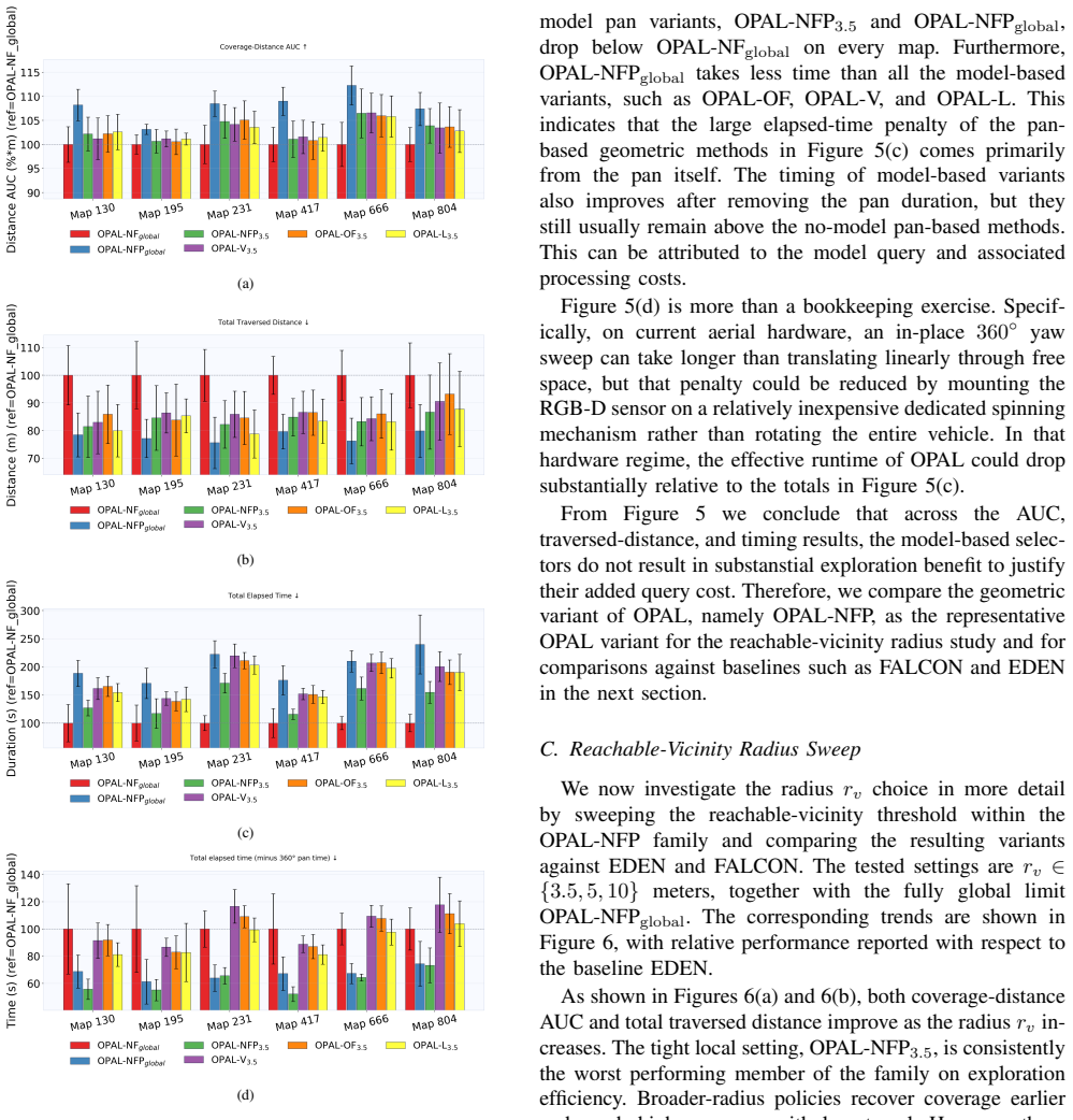
Autonomous exploration is critical for robot mapping unknown environments. Desirable characteristics of exploration algorithms include compute efficiency and small traversed distance during the exploration process. Motivated by these, we present Omnidirectional Path-efficient Aerial 3D expLoration (OPAL), an exploration framework centered on deliberate 360-degree yaw rotation at ambiguous branch points rather than compute-heavy global tour planning. We devise multiple variants of OPAL to determine the frontier-selection strategy once the yaw pan is completed. One variant is model-free, while others use large language models (LLMs) or vision-language models (VLMs). We characterize the performance of these variants while varying the vicinity search radius to include frontiers in the selection process. Through simulations we find that although the time-consuming in-place yaw rotation increases total exploration time relative to more computationally complex baselines such as EDEN and FALCON, OPAL is computationally simpler and achieves shorter travel distances and higher coverage-versus-distance area under the curve. We also show that adjusting the frontier-selection search radius enables a tradeoff between travel distance and total exploration time. We verify our results on a Modal AI drone in two indoor environments by comparing OPAL against FALCON, and find that the traveled distance for a variant of OPAL to be as much as 25% lower than FALCON.
Figures


Figures from the paper (5 more)



Reference graph
Works this paper leans on
-
[1]
A frontier-based approach for autonomous exploration,
B. Yamauchi, “A frontier-based approach for autonomous exploration,” inProceedings of the 1997 IEEE International Symposium on Com- putational Intelligence in Robotics and Automation (CIRA), 1997, pp. 146–151
1997
-
[2]
FALCON: Fast autonomous aerial exploration using coverage path guidance,
Y . Zhang, X. Chen, C. Feng, B. Zhou, and S. Shen, “FALCON: Fast autonomous aerial exploration using coverage path guidance,”IEEE Transactions on Robotics, 2024
2024
-
[3]
EDEN: Efficient dual-layer exploration planning for fast UA V autonomous ex- ploration in large 3-D environments,
Q. Dong, X. Zhang, S. Zhang, Z. Wang, Z. Ma, and H. Xi, “EDEN: Efficient dual-layer exploration planning for fast UA V autonomous ex- ploration in large 3-D environments,”IEEE Transactions on Industrial Electronics, 2025
2025
-
[4]
Lantern-explorer: A collision-avoidance autonomous exploration drone system based on laser slam with optimized hardware and software,
L. Zhu, R. Zhong, D. Xie, and X. Yuan, “Lantern-explorer: A collision-avoidance autonomous exploration drone system based on laser slam with optimized hardware and software,”ISPRS Annals of the Photogrammetry, Remote Sensing and Spatial Information Sciences, vol. X-G-2025, pp. 1077–1084, 2025
2025
-
[5]
Autonomous frontier-based exploration with high-level vlm guidance,
A. Aitha, “Autonomous frontier-based exploration with high-level vlm guidance,” Master’s thesis, University of California, Berkeley, August 2025, https://www-video.eecs.berkeley.edu/papers/aarushaitha/aarush thesis.pdf
2025
-
[6]
Autonomous frontier-based exploration with high-level VLM guidance,
A. Aitha and A. Zakhor, “Autonomous frontier-based exploration with high-level VLM guidance,” June 2026, accepted to the CVPR 2026 2nd Workshop on 3D-LLM/VLA: Bridging Language, Vision and Action in 3D Environments
2026
-
[7]
Receding horizon “next-best-view
A. Bircher, M. Kamel, K. Alexis, H. Oleynikova, and R. Siegwart, “Receding horizon “next-best-view” planner for 3D exploration,” in 2016 IEEE International Conference on Robotics and Automation (ICRA), 2016, pp. 1462–1468
2016
-
[8]
Efficient autonomous exploration planning of large-scale 3-d environments,
M. Selin, M. Tiger, D. Duberg, F. Heintz, and P. Jensfelt, “Efficient autonomous exploration planning of large-scale 3-d environments,” IEEE Robotics and Automation Letters, vol. 4, no. 2, pp. 1699–1706, 2019
2019
Show all 48 references
-
[9]
Informed sampling exploration path planner for 3d reconstruction of large scenes,
Y . Kompis, L. Bartolomei, R. Mascaro, L. Teixeira, and M. Chli, “Informed sampling exploration path planner for 3d reconstruction of large scenes,”IEEE Robotics and Automation Letters, vol. 6, no. 4, pp. 7894–7901, 2021
2021
-
[10]
A shadowcasting-based next-best-view planner for autonomous 3d ex- ploration,
A. Batinovic, A. Ivanovic, T. Petrovic, and S. Bogdan, “A shadowcasting-based next-best-view planner for autonomous 3d ex- ploration,”IEEE Robotics and Automation Letters, vol. 7, no. 2, pp. 2969–2976, 2022
2022
-
[11]
Fuel: Fast uav exploration using incremental frontier structure and hierarchical planning,
B. Zhou, Y . Zhang, X. Chen, and S. Shen, “Fuel: Fast uav exploration using incremental frontier structure and hierarchical planning,”IEEE Robotics and Automation Letters, vol. 6, no. 2, pp. 779–786, 2021
2021
-
[12]
Fsmp: A frontier-sampling-mixed planner for fast autonomous exploration of complex and large 3-d environments,
S. Zhang, X. Zhang, Q. Dong, Z. Wang, H. Xi, and J. Yuan, “Fsmp: A frontier-sampling-mixed planner for fast autonomous exploration of complex and large 3-d environments,”IEEE Transactions on Instrumentation and Measurement, vol. 74, pp. 1–14, 2025
2025
-
[13]
Flare: Fast large-scale autonomous exploration guided by unknown regions,
X. Liu, M. L. Lin, S. Li, G. Xu, Z. Wang, H. Wu, and Y . Liu, “Flare: Fast large-scale autonomous exploration guided by unknown regions,” IEEE Robotics and Automation Letters, vol. 10, no. 11, pp. 12 197– 12 204, 2025
2025
-
[14]
Ptplanner: Efficient autonomous uav exploration via prior-enhanced and topology-aware hierarchical planning,
C. Zhao, Z. Deng, Z. Zhang, and X. Guo, “Ptplanner: Efficient autonomous uav exploration via prior-enhanced and topology-aware hierarchical planning,”Drones, vol. 10, no. 3, p. 217, 2026
2026
-
[15]
Receding horizon path planning for 3d exploration and surface inspection,
A. Bircher, M. Kamel, K. Alexis, H. Oleynikova, and R. Siegwart, “Receding horizon path planning for 3d exploration and surface inspection,”Autonomous Robots, vol. 42, no. 2, pp. 291–306, 2018
2018
-
[16]
Efficient autonomous exploration with incrementally built topological map in 3-d environments,
C. Wang, H. Ma, W. Chen, L. Liu, and M. Q.-H. Meng, “Efficient autonomous exploration with incrementally built topological map in 3-d environments,”IEEE Transactions on Instrumentation and Measurement, vol. 69, no. 12, pp. 9853–9865, 2020
2020
-
[17]
Graph-based topological exploration planning in large-scale 3d environments,
F. Yang, D.-H. Lee, J. Keller, and S. Scherer, “Graph-based topological exploration planning in large-scale 3d environments,” in2021 IEEE International Conference on Robotics and Automation (ICRA), 2021, pp. 12 730–12 736
2021
-
[18]
A multi-resolution frontier-based planner for autonomous 3d explo- ration,
A. Batinovic, T. Petrovic, A. Ivanovic, F. Petric, and S. Bogdan, “A multi-resolution frontier-based planner for autonomous 3d explo- ration,”IEEE Robotics and Automation Letters, vol. 6, no. 3, pp. 4528– 4535, 2021
2021
-
[19]
Tare: A hierarchical framework for efficiently exploring complex 3d environments,
C. Cao, H. Zhu, H. Choset, and J. Zhang, “Tare: A hierarchical framework for efficiently exploring complex 3d environments,” in Proceedings of Robotics: Science and Systems (RSS), 2021
2021
-
[20]
Autonomous UA V exploration of dynamic environments via incremental sampling and probabilistic roadmap,
Z. Xu, D. Deng, and K. Shimada, “Autonomous UA V exploration of dynamic environments via incremental sampling and probabilistic roadmap,”IEEE Robotics and Automation Letters, vol. 6, no. 2, pp. 1679–1686, 2021
2021
-
[21]
Autonomous 3d exploration in large-scale environments with dynamic obstacles,
E. Wiman, L. Widen, M. Tiger, and F. Heintz, “Autonomous 3d exploration in large-scale environments with dynamic obstacles,” in 2024 IEEE International Conference on Robotics and Automation (ICRA), 2024, pp. 2389–2395
2024
-
[22]
Autonomous exploration method for fast unknown environment mapping by using uav equipped with limited fov sensor,
Y . Zhao, L. Yan, H. Xie, J. Dai, and P. Wei, “Autonomous exploration method for fast unknown environment mapping by using uav equipped with limited fov sensor,”arXiv preprint arXiv:2302.02293, 2023
2023
-
[23]
Autonomous exploration of unknown 3d environments using a frontier-based collector strategy,
I. D. Changoluisa Caiza, A. Milas, M. A. Montes Grova, F. J. Perez- Grau, and T. Petrovic, “Autonomous exploration of unknown 3d environments using a frontier-based collector strategy,” in2024 IEEE International Conference on Robotics and Automation (ICRA), 2024, pp. 13 566–13 572
2024
-
[24]
Efficient uav exploration for large-scale 3d environments using low-memory map,
J. Huang, Z. Fan, Z. Yan, P. Duan, R. Mei, and H. Cheng, “Efficient uav exploration for large-scale 3d environments using low-memory map,”Drones, vol. 8, no. 9, p. 443, 2024
2024
-
[25]
Pipe planner: Pathwise information gain with map predictions for indoor robot exploration,
S. Baek, B. Moon, S. Kim, M. Cao, C. Ho, S. Scherer, and J. H. Jeon, “Pipe planner: Pathwise information gain with map predictions for indoor robot exploration,” in2025 IEEE/RSJ International Conference on Intelligent Robots and Systems (IROS), Oct. 2025
2025
-
[26]
Path planner for autonomous exploration of underground mines by aerial vehicles,
C. Rubio-Sierra, D. Dominguez, J. Gonzalo, and A. Escapa, “Path planner for autonomous exploration of underground mines by aerial vehicles,”Sensors, vol. 20, no. 15, p. 4259, 2020
2020
-
[27]
Optimal frontier-based au- tonomous exploration in unconstructed environment using RGB-D sensor,
L. Lu, C. Redondo, and P. Campoy, “Optimal frontier-based au- tonomous exploration in unconstructed environment using RGB-D sensor,”Sensors, vol. 20, no. 22, p. 6507, 2020
2020
-
[28]
Surface-driven next-best-view planning for exploration of large-scale 3d environments,
G. Hardouin, F. Morbidi, J. Moras, J. Marzat, and E. M. Mouaddib, “Surface-driven next-best-view planning for exploration of large-scale 3d environments,” inIF AC-PapersOnLine, vol. 53, no. 2, 2020, pp. 15 501–15 507
2020
-
[29]
Topological map-based autonomous exploration in large-scale scenes for unmanned vehicles,
Z. Cao, Z. Du, and J. Yang, “Topological map-based autonomous exploration in large-scale scenes for unmanned vehicles,”Drones, vol. 8, no. 4, p. 124, 2024
2024
-
[30]
Topological frontier- based exploration and map-building using semantic information,
C. Gomez, A. C. Hernandez, and R. Barber, “Topological frontier- based exploration and map-building using semantic information,” Sensors, vol. 19, no. 20, p. 4595, 2019
2019
-
[31]
Asep: An autonomous seman- tic exploration planner with object labeling,
A. Milas, A. Ivanovic, and T. Petrovic, “Asep: An autonomous seman- tic exploration planner with object labeling,”IEEE Access, vol. 11, pp. 107 169–107 183, 2023
2023
-
[32]
Do as I can, not as I say: Grounding language in robotic affordances,
M. Ahn, A. Brohan, N. Brown, Y . Chebotar, O. Cortes, B. David, C. Finn, C. Fu, K. Gopalakrishnan, K. Hausman, A. Herzog, D. Ho, J. Hsu, J. Ibarz, B. Ichter, A. Irpan, E. Jang, R. J. Ruano, K. Jeffrey, S. Jesmonth, N. J. Joshi, R. Julian, D. Kalashnikov, Y . Kuang, K. Lee, S. ...
2022 arXiv
-
[33]
PaLM- E: An embodied multimodal language model,
D. Driess, F. Xia, M. S. M. Sajjadi, C. Lynch, A. Chowdhery, B. Ichter, A. Wahid, J. Tompson, Q. Vuong, T. Yu, W. Huang, Y . Chebotar, P. Sermanet, D. Duckworth, S. Levine, V . Vanhoucke, K. Hausman, M. Toussaint, K. Greff, A. Zeng, I. Mordatch, and P. Florence, “PaLM- E: An e...
2023
-
[34]
Depth-first search and linear graph algorithms,
R. Tarjan, “Depth-first search and linear graph algorithms,”SIAM Journal on Computing, vol. 1, no. 2, pp. 146–160, 1972
1972
-
[35]
Sensor-based exploration for general robotic systems,
L. Freda, G. Oriolo, and F. Vecchioli, “Sensor-based exploration for general robotic systems,” in2008 IEEE/RSJ International Conference on Intelligent Robots and Systems, 2008, pp. 2157–2164
2008
-
[36]
Exploring unstructured environment with frontier trees,
R. Korb and A. Sch ¨ottl, “Exploring unstructured environment with frontier trees,”Journal of Intelligent & Robotic Systems, vol. 91, no. 2, pp. 617–628, 2018
2018
-
[37]
Habitat-Matterport 3D dataset (HM3D): 1000 large-scale 3D environments for embodied AI,
S. K. Ramakrishnan, A. Gokaslan, E. Wijmans, O. Maksymets, A. Clegg, J. M. Turner, E. Undersander, W. Galuba, A. Westbury, A. X. Chang, M. Savva, Y . Zhao, and D. Batra, “Habitat-Matterport 3D dataset (HM3D): 1000 large-scale 3D environments for embodied AI,” inAdvances in Neu...
2021
-
[38]
Accessed May 19,
Blender Foundation,Blender, Blender Foundation, Amsterdam, The Netherlands, 2026, open-source 3D creation suite. Accessed May 19,
2026
-
[39]
Available: https://www.blender.org/
[Online]. Available: https://www.blender.org/
-
[40]
Gleam: Learning generalizable exploration policy for active mapping in com- plex 3d indoor scenes,
X. Chen, T. Wang, Q. Li, T. Huang, J. Pang, and T. Xue, “Gleam: Learning generalizable exploration policy for active mapping in com- plex 3d indoor scenes,”arXiv preprint arXiv:2505.20294, 2025
2025
-
[41]
Gennbv: Generalizable next-best-view policy for active 3d reconstruction,
X. Chen, Q. Li, T. Wang, T. Xue, and J. Pang, “Gennbv: Generalizable next-best-view policy for active 3d reconstruction,” inProceedings of the IEEE/CVF Conference on Computer Vision and Pattern Recogni- tion (CVPR), June 2024, pp. 16 436–16 445
2024
-
[42]
Hestia: V oxel-face-aware hierarchical next- best-view acquisition for efficient 3d reconstruction,
C.-Y . Lu, Z. Zhuang, N. T. T. Le, D. Xiao, Y .-C. Chang, T. Do, S. Sridhar, and C.-T. Lin, “Hestia: V oxel-face-aware hierarchical next- best-view acquisition for efficient 3d reconstruction,” inProceedings of the IEEE/CVF Winter Conference on Applications of Computer Vision ...
2026
-
[43]
VOXL 2 - D0014 Architecture (Starling 2),
ModalAI, “VOXL 2 - D0014 Architecture (Starling 2),” https://docs. modalai.com/voxl2-d0014/, 2026, accessed April 30, 2026
2026
-
[44]
VOXL 2 Coax Camera Bundles,
——, “VOXL 2 Coax Camera Bundles,” https://docs.modalai.com/ voxl2-coax-camera-bundles/, 2026, accessed April 30, 2026
2026
-
[45]
VOXL Open-VINS Server,
——, “VOXL Open-VINS Server,” https://docs.modalai.com/ voxl-open-vins-server/, 2026, accessed April 30, 2026
2026
-
[46]
Modal Pipe Architecture,
——, “Modal Pipe Architecture,” https://docs.modalai.com/mpa/, 2026, accessed April 30, 2026
2026
-
[47]
VOXL Vision Hub,
——, “VOXL Vision Hub,” https://docs.modalai.com/ voxl-vision-hub/, 2026, accessed April 30, 2026
2026
-
[48]
VOXL PX4,
——, “VOXL PX4,” https://docs.modalai.com/voxl-px4/, 2026, ac- cessed April 30, 2026
2026
Reviewed June 29, 2026 · model on record in the stance chip above.
Discussion (0). Continue with ORCID to comment.