REVIEW 3 major objections 5 minor 1 cited by
Adaptive continuity-preserving simplification of street networks
T0 review · 3 major / 5 minor · reviewed 2026-08-16 · deepseek-v4-flash
Pith's one-line read A fully automated algorithm can simplify street networks to single-line form as faithfully as manual human cleaning, outperforming all tested automated methods.
desk verdict A genuinely new, well-packaged street network simplification algorithm whose outperformance claim is real but narrower than the abstract suggests, because the manual gold standard and stroke metrics share the algorithm's own design philosophy. read the letter →
The pith
A machine-rendered reading of the paper's core claim, the machinery that carries it, and where it could break.
The reading
What carries the argument
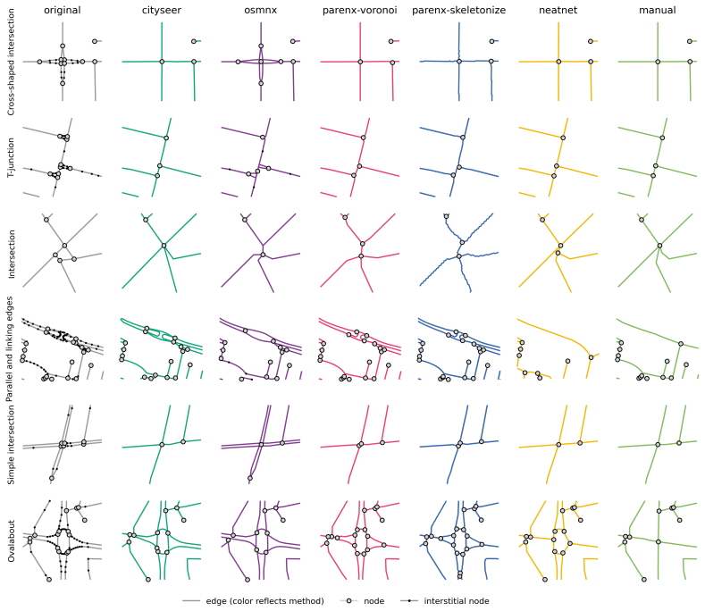
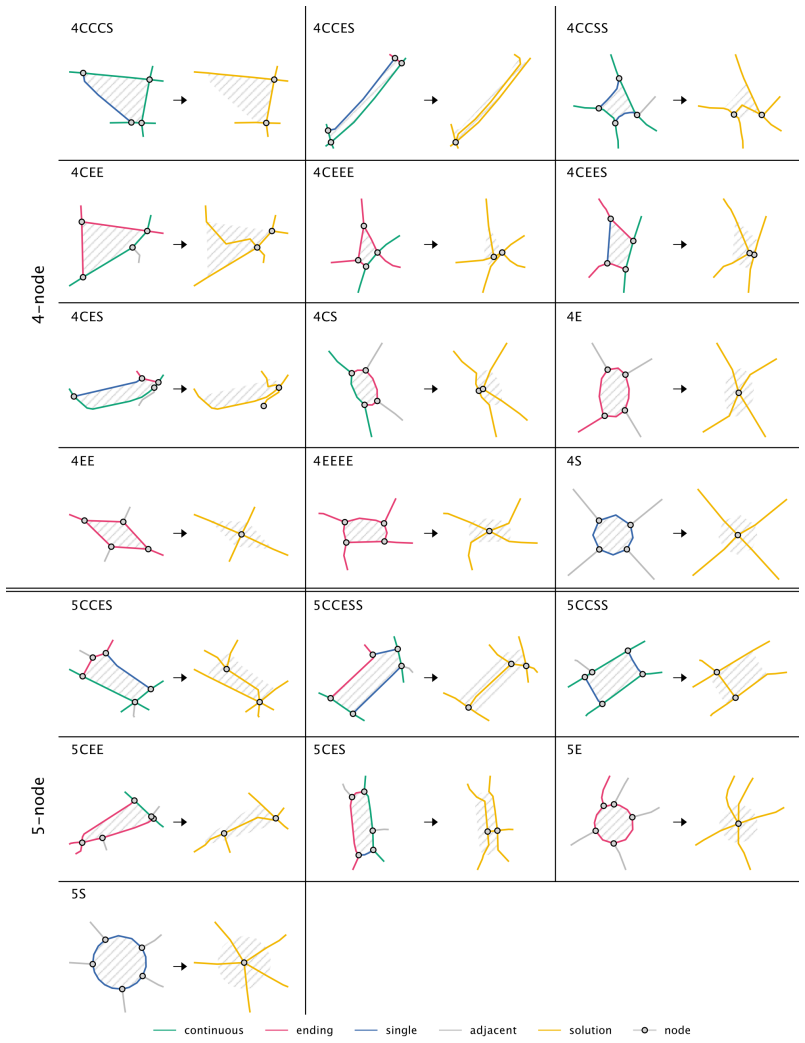
The engine is a two-pass loop built around three components. Face artifact detection polygonizes the network and flags sliver-like faces using a shape-based heuristic threshold, then extends the flag to touching, geometrically similar polygons and can accept an exclusion mask so that faces containing buildings or water are never treated as artifacts. CES classification splits artifact polygons into isolates, pairs, and clusters, and labels their boundary edges as continuous, ending, or single strokes; these stroke types come from continuity strokes, chains of consecutive edges with interior angles typically above 120 degrees, extended into a flow mode that only breaks strokes at street network nodes. Geometry replacement then applies CES-specific heuristics for single artifacts, removes shared edges for appropriate pairs, and replaces merged clusters by a Voronoi skeleton of their edges, marking each resulting geometry as new or extended. The simplified output is run through detection and topological post-processing a second time to catch artifacts created by the first pass.
What would settle it
Have an independent team that has not seen Appendix A manually simplify a mid-size city outside the seven, using their own preferred rules, and check whether the proposed algorithm still comes closest to that independent ground truth on the majority of the seven metrics. A cheaper check is to run all methods on national mapping agency street data rather than OpenStreetMap; the paper itself expects simplification needs could differ, so any reversal there would bound the claim to OSM-style inputs.
Extended reading notes
Core claim
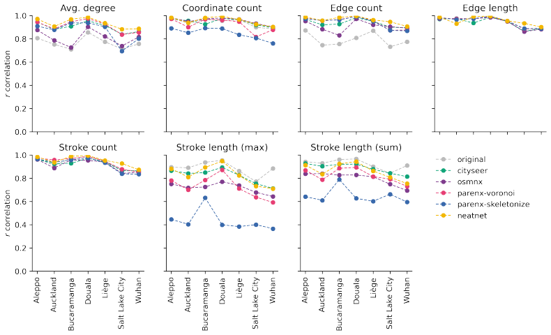
The paper's central claim is that adaptive continuity-preserving simplification converts a granular, transport-oriented street graph into its most simple morphological form automatically and reproducibly, and that among currently available automated procedures it comes closest to manual human simplification. The evaluation compares seven functional urban areas spanning different street paradigms, using seven structural metrics measured cell by cell on a hexagonal grid: average node degree, coordinate count, edge count, total edge length, stroke count, longest stroke, and total stroke length. On both a rank correlation coefficient and absolute deviation between method outputs and the manual ground truth, the proposed algorithm places first in the large majority of city-metric combinations. The paper is explicit that it does not win every single case, but it reports consistent overall superiority under fully automatic, default-parameter, attribute-agnostic conditions.
Load-bearing premise
The evaluation assumes that the manually simplified networks produced by the authors and their helpers, following the protocol in Appendix A, are the correct universal result of simplification, and that the seven chosen cities span the range of real simplification needs; if either assumption fails, the comparative conclusion may not transfer.
Editorial extensions
If this is right
- Morphological studies can skip manual digitization: a one-argument function turns drive-oriented maps into block-and-street form on which standard urban-form metrics become meaningful.
- Users get continuity-preserving results without tuning parameters for each city, because the face-artifact threshold adapts from local geometry, and building or water polygons can be supplied as an exclusion mask to avoid false positives.
- Because only artifact-bounded geometry is altered, attributes on untouched edges survive, and the only attribute-less parts are the newly generated connections, making downstream attribute transfer more localized than with whole-network approaches.
- Analyses distorted by dual carriageways or interchange slivers, such as block delineation, streetscape classification, GPS map-matching, and drone routing, can be run directly on the simplified output.
- The reported median runtime of roughly one minute per city and moderate memory use make batch simplification of many cities feasible on an ordinary workstation, though slower than the least thorough baseline.
Reading between the lines
- If we extend the logic, an independent benchmark using simplifiers who have not seen this paper's protocol would be the decisive test; the current result is measured against a ground truth produced by the authors and helpers following their own Appendix A protocol.
- The algorithm separates what to change (face artifacts) from how to change (CES heuristics), suggesting a modular path to generalization: retune the artifact detector for railways, canals, or non-OSM network sources rather than rewrite the replacement logic.
- Because adding a building exclusion mask consistently nudges outputs closer to manual results, a learning-based extension that infers which faces are real blocks from local context is a natural next step and would let the method improve wherever auxiliary data exist.
- The authors themselves note that results may shift for non-OSM data and that fine-tuning defaults can improve comparators; the paper's claim of superiority is therefore specific to fully automatic, attribute-agnostic, default-parameter use on OpenStreetMap inputs, not to every possible configuration.
Signed reviews
Editorial analysis
A structured set of objections, weighed in public.
Referee Report
Summary. The paper defines street network simplification as the conversion of transportation-level graph data (e.g., OSM) into a morphological network in which each intersection is one node and each street segment is one edge. It then presents a fully automated, attribute-agnostic algorithm, released as the neatnet Python package, that performs topology verification, face-artifact detection, continuity-based CES classification, and geometry replacement, iterated twice. The method is evaluated on seven Functional Urban Areas against the outputs of cityseer, OSMnx, and both parenx variants, using manually simplified networks as a ground truth and seven grid-cell metrics. The paper reports that neatnet generally achieves the highest Chatterjee correlation and lowest Euclidean deviation from the manual simplifications, while also reporting runtime and memory comparisons. The code and data are openly archived, and the algorithm is described in sufficient detail to be reproduced.
Significance. If the comparative claim holds, this is a genuinely useful contribution: neatnet would be the first fully automated, attribute-agnostic, case-agnostic, packaged method that a morphology researcher can run with a single function call, and the paper provides reproducible code, an archived implementation, and a thoughtful decomposition of the simplification problem into subtasks. The computational-efficiency comparison (Table 3) and the detailed manual protocol (Appendix A) are also valuable resources for the community. However, the central claim that neatnet 'outperforms current state-of-the-art procedures' is heavily dependent on an evaluation design in which the ground truth and three of the seven metrics encode the same continuity-preserving objective that the algorithm is explicitly designed to optimize. The paper's own discussion (Section 7) concedes that tuned baselines would likely perform better. The result is a promising self-consistency demonstration, but the general outperformance claim needs either an independent reference standard or a substantially more guarded statement. This is a fixable issue rather than a defect in the algorithm itself.
major comments (3)
- [Evaluation design (§5, §6.2, Appendix A)] The 'ground truth' used for the comparison is not independent of the algorithm's design. The manual simplification protocol in Appendix A, Table 4, defines the target operations as collapsing parallel edges, replacing roundabouts with intersections, deleting diverging streets, and preserving continuity — precisely the operations that neatnet's face-artifact detection, CES classification, and continuity-preserving geometry replacement are built to perform (§4). In addition, three of the seven evaluation metrics (stroke count, longest stroke, and total stroke length) are computed from the same Tripathy et al. (2021) continuity-stroke decomposition that §4 uses internally to decide which edges to alter. The evaluation is therefore best described as a self-consistency check between neatnet and a hand-coded version of its own objective, not as validation against an independent criterion. This is load-bearing for the 'outperforms' claim in the abstract and introduction. I recommend adding an independent human reference (e.g., external raters blind to the algorithm, a second protocol produced by different authors, or a published ground-truth dataset), or substantially restricting the claim to 'outperforms under the authors' manual-simplification protocol and continuity-stroke metrics,' and adding at least one quality metric that is not tied to continuity-stroke preservation.
- [Comparative evaluation (§5, §7, Eqs. (1)–(2))] The comparative conclusion rests solely on default-parameter runs. Section 5 states that cityseer, OSMnx, and parenx are used 'with the default parameters only,' and Section 7 concedes that with manually fine-tuned parameters 'both OSMnx and cityseer will likely be able to reach lower deviations from the manual ground truth data.' The paper reports no sensitivity analysis, no tuned-baseline comparison, and no uncertainty quantification or significance testing on the cell-level differences behind Eqs. (1) and (2); Figures 4 and 5 present point values only. Without this evidence, the headline outperformance claim is not robust to plausible configurations of the competing tools. Please add at least a baseline-tuning sensitivity analysis with documented parameter grids and a paired significance test or confidence intervals on the per-cell metric differences, or broaden the scope statement to make clear that the result applies to out-of-the-box defaults.
- [Sample and scope (§5, Table 1, §7)] The generality of the 'outperforms' claim is not supported by the sample. The seven FUAs are heterogeneous in geography, but the paper does not justify them as representative of the range of real simplification needs, and all inputs are OpenStreetMap data; Section 7 explicitly limits the findings to OSM and notes that other data sources may behave differently. The abstract's unqualified statement 'outperforms current state-of-the-art procedures' therefore overstates the evidence. I recommend either adding a formal representativeness argument or revising the abstract and introduction to scope the claim to the tested conditions (OSM-derived street networks across the seven listed FUAs, under the evaluation protocol defined in §5).
minor comments (5)
- [§6.1] The phrase 'computational efficency' in the paragraph before Table 3 should read 'computational efficiency.'
- [Figure 6 caption] The caption contains a typo: 'resutling simplified networks' should be 'resulting simplified networks.'
- [Abstract and §7] The abstract's unqualified 'outperforms current state-of-the-art procedures' conflicts with the more careful final sentence of Section 7, which says the algorithm does not outperform universally. Please align these statements.
- [Appendix F] The claim that Chatterjee's xi 'proves more effective to distinguish between the methods' is asserted without a formal justification; it would be helpful to state a criterion (e.g., separation of method rankings or type of dependence) that motivated this choice.
- [§4] The phrase 'automatically derived threshold' for face artifact detection is used without specifying the derivation; please either restate the relevant formula from Fleischmann and Vybornova (2024) or provide an equation number for the definition.
Circularity Check
Partially circular evaluation: the manual gold standard and the stroke-based metrics embed the same continuity-preserving objective that neatnet is engineered to optimize.
-
other
[Section 5 (Evaluation), Section 6.2 (Simplification performance), Appendix A (Manual simplification protocol), Section 7 (Discussion)]
"To evaluate simplification performance, we compute the deviation of the street network simplified by each of the tested methods from the one simplified manually, which is considered the “ground truth” in this scenario ... Table 4 details 19 cases as a protocol for manual simplification ... In this work, we are using one perspective on what simplification is and how it should be conceptualised, focusing on preserving configurative and continuity properties of the networks."
The reference against which neatnet is judged was produced by the authors and their helpers under a 19-case protocol whose entries (roundabouts, parallel edges, cloverleaf interchanges, ovalabouts) are the very artifact classes that neatnet's face-artifact detection and CES classification were built to resolve. The discussion also concedes that the paper adopts one specific continuity-focused definition of simplification. Thus the 'manual ground truth' is not an independent external criterion; it is a hand-coded version of the same morphological objective embedded in the algorithm, so the headline 'outperforms state of the art' is partially an artifact of benchmark construction. This is evaluation circularity rather than a derivation, and it weakens but does not eliminate the comparison.
-
other
[Section 4 (Adaptive continuity-preserving simplification, classification paragraph) and Section 5 (quantitative similarity-based performance, metrics 5-7)]
"The continuity-based classification is based on the algorithm proposed by Tripathy et al. (2021), implemented in the Python package momepy (Fleischmann, 2019) ... The reason for this approach is to ensure that when a geometry is modified to remove the face artifact, the modification does not significantly alter the continuity of the resulting network. ... 5) number of continuity strokes intersecting the cell; 6) maximum length of continuity strokes intersecting the cell; and 7) total length of continuity strokes intersecting the cell."
Three of the seven performance metrics are computed from the same continuity-stroke decomposition (Tripathy et al., 2021, with the authors' flow-mode extension) that neatnet uses internally to decide which edges to alter: it preferentially simplifies S, then E, and leaves C strokes intact. On these stroke metrics, neatnet is therefore rewarding a property that the algorithm was explicitly designed to preserve, so its strong showing is in part a restatement of its design objective rather than an independent measure of agreement with human judgment. The other four metrics (node degree, coordinate count, edge count, total length) remain independent, which keeps this partial circularity moderate.
full rationale
This paper is an empirical evaluation rather than a formal derivation, and I find no mathematical self-definition or fitted-parameter-as-prediction in the usual sense: neatnet is not calibrated to the benchmark, and the comparison against OSMnx, cityseer, and parenx uses fixed defaults. The main circularity burden lies in the evaluation design. First, the manual gold standard was created by the authors and their helpers using a protocol whose cases mirror neatnet's artifact types and continuity-preserving philosophy, so the benchmark is not independent of the method's design goal. Second, three of the seven similarity metrics are derived from the same continuity-stroke algorithm (Tripathy et al., 2021; momepy) that neatnet uses internally for CES classification; high performance on those metrics partly reflects objective alignment, not an external judgment. These issues are real but partial: the algorithmic pipeline contains independent content (topological verification, face-artifact detection, CES heuristics, Voronoi-based cluster replacement), the remaining four metrics are not aligned with the design objective, and the paper candidly concedes in Section 7 that OSMnx and cityseer would likely improve with tuned parameters and that other simplification perspectives would change the results. The self-citations to Fleischmann and Vybornova (2024) and Tripathy et al. (2021) point to published, code-backed methods, so by themselves they are not load-bearing circularity. Overall, the central claim 'outperforms state of the art' is plausible but not yet established against an independent ground truth; the circularity score is 4, reflecting moderate, evaluation-level circularity rather than a derivation that reduces to its inputs by construction.
Assumptions & free parameters
free parameters (5)
- node consolidation tolerance =
2 meters (default)
- continuity angle threshold =
120 degrees (typical)
- face artifact index threshold =
automatically derived per network
- segmentation density =
not explicitly reported
- number of iterative loops =
2
assumptions (5)
- domain assumption Manual simplification protocol in Appendix A is a valid ground truth for correct simplification
- domain assumption Face artifact detection of Fleischmann and Vybornova (2024) correctly identifies all portions needing simplification across diverse contexts
- domain assumption Continuity strokes, as defined by Tripathy et al. (2021) with the added flow mode, capture natural perceptual continuity of streets
- domain assumption OSM-derived networks used for evaluation are representative of street network simplification needs
- domain assumption Degree-2 nodes can be removed without loss of morphological meaning
Cite this review
Pith. "Pith review of Adaptive continuity-preserving simplification of street networks." pith.science (2026). https://pith.science/paper/NM5XV2PD
@misc{pith2026250416198,
  author       = {Pith},
  title        = {Pith review of: Adaptive continuity-preserving simplification of street networks},
  year         = {2026},
  howpublished = {\url{https://pith.science/paper/NM5XV2PD}},
  note         = {Machine review of arXiv:2504.16198}
}
read the original abstract
Street network data is widely used to study human-based activities and urban structure. Often, these data are geared towards transportation applications, which require highly granular, directed graphs that capture the complex relationships of potential traffic patterns. While this level of network detail is critical for certain fine-grained mobility models, it represents a hindrance for studies concerned with the morphology of the street network. For the latter case, street network simplification - the process of converting a highly granular input network into its most simple morphological form - is a necessary, but highly tedious preprocessing step, especially when conducted manually. In this manuscript, we develop and present a novel adaptive algorithm for simplifying street networks that is both fully automated and able to mimic results obtained through a manual simplification routine. The algorithm - available in the neatnet Python package - outperforms current state-of-the-art procedures when comparing those methods to manually, human-simplified data, while preserving network continuity.
Figures


Figures from the paper (11 more)







Forward citations
Cited by 1 Pith paper
-
The Trade-Off between Directness and Coverage in Transport Network Growth
On stylized transport networks, manual link-ordering strategies outperform greedy and random strategies in the directness-coverage trade-off, with centrality-based greedy best for directness and coverage-based greedy ...
Reference graph
Works this paper leans on
-
[1]
L. M. Aiello, A. Vybornova, S. Juhász, M. Szell, and E. Bokányi. Urban highways are barriers to social ties. Proceedings of the National Academy of Sciences, 122 0 (10): 0 e2408937122, Mar. 2025. doi:10.1073/pnas.2408937122. URL https://www.pnas.org/doi/10.1073/pnas.2408937122. Publisher: Proceedings of the National Academy of Sciences
-
[2]
A. Araldi and G. Fusco. Multi-level street-based analysis of the urban fabric: Developments for a nationwide taxonomy. Geographical Analysis, 2024. doi:10.1111/gean.12416. Publisher: Wiley Online Library
-
[3]
D. Arribas-Bel and M. Fleischmann. Spatial Signatures - Understanding (urban) spaces through form and function. Habitat International, 128: 0 102641, Oct. 2022. ISSN 0197-3975. doi:10.1016/j.habitatint.2022.102641. URL https://www.sciencedirect.com/science/article/pii/S0197397522001382
arXiv 2022
-
[4]
C. A. Badea, A. Morfin Veytia, M. Ribero, J. Ellerbroek, and J. Hoekstra. Limitations of Conflict Prevention and Resolution in Constrained Very Low - Level Urban Airspace . In 11th SESAR Innovation Days , virtual, 2021. URL https://www.researchgate.net/publication/356717349_Limitations_of_Conflict_Prevention_and_Resolution_in_Constrained_Very_Low-Level_Ur...
-
[5]
L. Ballo and K. W. Axhausen. Modeling sustainable mobility futures using an automated process of road space reallocation in urban street networks: A case study in Zurich . Arbeitsberichte Verkehrs- und Raumplanung, 1835, Aug. 2023. doi:10.3929/ethz-b-000624902. URL https://www.research-collection.ethz.ch/handle/20.500.11850/624902
-
[6]
L. Ballo, K. W. Axhausen, and M. Raubal. Designing an E - Bike City : An automated process for network-wide multimodal road space reallocation. Arbeitsberichte Verkehrs- und Raumplanung, 1881, June 2024. doi:10.3929/ethz-b-000679713. URL https://www.research-collection.ethz.ch/handle/20.500.11850/679713. Accepted: 2024-10-30T08:09:58Z Publisher: IVT and I...
-
[7]
M. Barthélemy and A. Flammini. Modeling Urban Street Patterns . Physical Review Letters, 100 0 (13): 0 138702, Apr. 2008. doi:10.1103/PhysRevLett.100.138702. URL https://link.aps.org/doi/10.1103/PhysRevLett.100.138702. Publisher: American Physical Society
-
[8]
L. Baur, S. Funke, T. Rupp, and S. Storandt. Gradual road network simplification with shape and topology preservation. In Proceedings of the 30th International Conference on Advances in Geographic Information Systems , SIGSPATIAL '22, pages 1--4, New York, NY, USA, Nov. 2022. Association for Computing Machinery. ISBN 978-1-4503-9529-8. doi:10.1145/3557915...
arXiv 2022
Show all 64 references
-
[9]
J. T. Bjørke and E. Isaksen. Map Generalization of Road Networks : Case study from Norwegian small scale maps. Proceedings to the XXII International Cartographic Conference, 2005
2005
-
[10]
G. Boeing. OSMnx : New methods for acquiring, constructing, analyzing, and visualizing complex street networks. Computers, Environment and Urban Systems, 65: 0 126--139, Sept. 2017. ISSN 01989715. doi:10.1016/j.compenvurbsys.2017.05.004. URL https://linkinghub.elsevier.com/ret...
2017 doi
-
[11]
G. Boeing. Modeling and Analyzing Urban Networks and Amenities with OSMnx . 2024. URL https://geoffboeing.com/publications/osmnx-paper/
2024
-
[12]
G. Boeing. Topological graph simplification solutions to the street intersection miscount problem. Transactions in GIS, 2025
2025
-
[13]
Boeing, C
G. Boeing, C. Higgs, S. Liu, B. Giles-Corti, J. F. Sallis, E. Cerin, M. Lowe, D. Adlakha, E. Hinckson, A. V. Moudon, D. Salvo, M. A. Adams, L. V. Barrozo, T. Bozovic, X. Delclòs-Alió, J. Dygrýn, S. Ferguson, K. Gebel, T. P. Ho, P.-C. Lai, J. C. Martori, K. Nitvimol, A. Queralt...
2022
-
[14]
Bongiorno, Y
C. Bongiorno, Y. Zhou, M. Kryven, D. Theurel, A. Rizzo, P. Santi, J. Tenenbaum, and C. Ratti. Vector-based pedestrian navigation in cities. Nature Computational Science, 1 0 (10): 0 678--685, Oct. 2021. ISSN 2662-8457. doi:10.1038/s43588-021-00130-y. URL https://www.nature.com...
2021 doi
-
[15]
Chatterjee
S. Chatterjee. A new coefficient of correlation. Journal of the American Statistical Association, 116 0 (536): 0 2009--2022, 2021. doi:10.1080/01621459.2020.1758115. URL https://doi.org/10.1080/01621459.2020.1758115
2009
-
[16]
A. Cohen. From Complexity to Clarity : Simplifying OpenStreetMap Data for Improved Active Transportation Analysis . In State of the Map 2024 , Nairobi, 2024. URL http://2024.stateofthemap.org/sessions/LAZXYU/
2024
-
[17]
Cororan and R
P. Cororan and R. Lewis. A user-centric model of connectivity in street networks. Computers & Operations Research, 173: 0 106846, Jan. 2025. ISSN 0305-0548. doi:10.1016/j.cor.2024.106846. URL https://www.sciencedirect.com/science/article/pii/S0305054824003186
2025
-
[18]
V. Dahmen. OSMNetFusion : A tool to generate a multimodal topologically-simplified OpenStreetMap network. The network is enriched with open-source data and tag-information is preserved., 2025. URL https://github.com/VictoriaDhmn/OSMNetFusion
2025
-
[19]
C. B. Daniel, S. Mathew, and S. Subbarayan. GIS - Based Study on the Association Between Road Centrality and Socio -demographic Parameters : a Case Study . Journal of Geovisualization and Spatial Analysis, 6 0 (1): 0 1, Dec. 2021. ISSN 2509-8829. doi:10.1007/s41651-021-00095-6...
2021 doi
-
[20]
Deakin and R
W. Deakin and R. Lovelace. anisotropi4/parenx: Pare or simplify a network using raster image skeletonization and Voronoi polygons, 2024. URL https://github.com/anisotropi4/parenx
2024
-
[21]
Dibble, A
J. Dibble, A. Prelorendjos, O. Romice, M. Zanella, E. Strano, M. Pagel, and S. Porta. On the origin of spaces: Morphometric foundations of urban form evolution. Environment and Planning B: Urban Analytics and City Science, 46 0 (4): 0 707--730, May 2019. ISSN 2399-8083, 2399-8...
2019 doi
-
[22]
El Gouj, C
H. El Gouj, C. Rincón-Acosta, and C. Lagesse. Urban morphogenesis analysis based on geohistorical road data. Applied Network Science, 7 0 (1): 0 1--26, Dec. 2022. ISSN 2364-8228. doi:10.1007/s41109-021-00440-0. URL https://appliednetsci.springeropen.com/articles/10.1007/s41109...
2022 doi
-
[23]
Simplify Line ( Cartography )— ArcGIS Pro Documentation , 2024
Esri. Simplify Line ( Cartography )— ArcGIS Pro Documentation , 2024. URL https://pro.arcgis.com/en/pro-app/3.1/tool-reference/cartography/simplify-line.htm
2024
-
[24]
Fleischmann
M. Fleischmann. momepy: Urban Morphology Measuring Toolkit . Journal of Open Source Software, 4 0 (43): 0 1807, Jan. 2019. doi:10.21105/joss.01807
2019 doi
-
[25]
Fleischmann and A
M. Fleischmann and A. Vybornova. A shape-based heuristic for the detection of urban block artifacts in street networks. Journal of Spatial Information Science, 28: 0 75--102, June 2024. ISSN 1948-660X. doi:10.5311/JOSIS.2024.28.31. URL https://josis.org/index.php/josis/article...
2024 doi
-
[26]
J. D. Gaboardi, D. C. Folch, and M. W. Horner. Connecting Points to Spatial Networks : Effects on Discrete Optimization Models . Geographical Analysis, 52 0 (2): 0 299--322, 2020. ISSN 1538-4632. doi:10.1111/gean.12211. URL https://onlinelibrary.wiley.com/doi/abs/10.1111/gean.12211
2020 doi
-
[27]
J. D. Gaboardi, S. Rey, and S. Lumnitz. spaghetti: spatial network analysis in PySAL . Journal of Open Source Software, 6 0 (62): 0 2826, June 2021. ISSN 2475-9066. doi:10.21105/joss.02826. URL https://joss.theoj.org/papers/10.21105/joss.02826
2021 doi
-
[28]
Hendawi, J
A. Hendawi, J. A. Stankovic, A. Taha, S. El-Sappagh, A. A. Ahmadain, and M. Ali. Road network simplification for location-based services. GeoInformatica, 24 0 (4): 0 801--826, Oct. 2020. ISSN 1573-7624. doi:10.1007/s10707-020-00406-x. URL https://doi.org/10.1007/s10707-020-00406-x
2020 doi
-
[29]
J. Herring. Opengis implementation standard for geographic information-simple feature access-part 1: Common architecture. Open Geospatial Consortium Inc, page 111, 2011. URL http://portal.opengeospatial.org/files/?artifact_id=25355
2011
-
[30]
B. Hillier. Space is the machine : a configurational theory of architecture. Cambridge University Press, Cambridge, Jan. 1996
1996
-
[31]
B. Jiang. The Fractal Nature of Maps and Mapping . International Journal of Geographical Information Science, 29 0 (1): 0 159--174, Jan. 2015. ISSN 1365-8816, 1362-3087. doi:10.1080/13658816.2014.953165. URL http://arxiv.org/abs/1406.5410. arXiv:1406.5410 [math]
2015
-
[32]
Jiang and C
B. Jiang and C. Claramunt. A Structural Approach to the Model Generalization of an Urban Street Network *. GeoInformatica, 8 0 (2): 0 157--171, June 2004. ISSN 1573-7624. doi:10.1023/B:GEIN.0000017746.44824.70. URL https://doi.org/10.1023/B:GEIN.0000017746.44824.70
2004
-
[33]
Jiang, X
B. Jiang, X. Liu, and T. Jia. Scaling of Geographic Space as a Universal Rule for Map Generalization . Annals of the Association of American Geographers, 103 0 (4): 0 844--855, July 2013. ISSN 0004-5608. doi:10.1080/00045608.2013.765773. URL https://doi.org/10.1080/00045608.20...
2013
-
[34]
K. Karimi. Space syntax: consolidation and transformation of an urban research field. Journal of Urban Design, 23 0 (1): 0 1--4, Jan. 2018. ISSN 1357-4809. doi:10.1080/13574809.2018.1403177. URL https://doi.org/10.1080/13574809.2018.1403177
2018
-
[35]
Knaap and S
E. Knaap and S. Rey. Segregated by design? Street network topological structure and the measurement of urban segregation. Environment and Planning B, 51 0 (7): 0 1408--1429, Sept. 2024. ISSN 2399-8083. doi:10.1177/23998083231197956. URL https://doi.org/10.1177/2399808323119795...
2024 doi
-
[36]
K. Krenz. Employing volunteered geographic information in space syntax analysis, July 2017. URL http://www.11ssslisbon.pt/docs/book-proceedings-29032018.pdf. Conference Name: The 11th Space Syntax Symposium ISSN: 978-972-98994-4-7 Meeting Name: The 11th Space Syntax Symposium ...
2017
-
[37]
Louf and M
R. Louf and M. Barthelemy. A typology of street patterns. Journal of the Royal Society Interface, 11, Oct. 2014. doi:http://dx.doi.org/10.1098/rsif.2014.0924
2014
-
[38]
Lovelace
R. Lovelace. Open source tools for geographic analysis in transport planning. Journal of Geographical Systems, 23 0 (4): 0 547--578, Oct. 2021. ISSN 1435-5949. doi:10.1007/s10109-020-00342-2. URL https://doi.org/10.1007/s10109-020-00342-2
2021 doi
-
[39]
Lovelace, Z
R. Lovelace, Z. Wang, W. Deakin, and J. Parry. Route network simplification for transport planning. 2024. URL https://nptscot.github.io/networkmerge/paper.html
2024
-
[40]
Mackaness, D
W. Mackaness, D. Burghardt, and C. Duchêne. Map Generalisation : Fundamental to the Modelling and Understanding of Geographic Space . In D. Burghardt, C. Duchêne, and W. Mackaness, editors, Abstracting Geographic Information in a Data Rich World : Methodologies and Application...
2014 doi
-
[41]
Marshall, J
S. Marshall, J. Gil, K. Kropf, M. Tomko, and L. Figueiredo. Street Network Studies : from Networks to Models and their Representations . Networks and Spatial Economics, 18 0 (3): 0 735--749, Sept. 2018. ISSN 1572-9427. doi:10.1007/s11067-018-9427-9. URL https://doi.org/10.1007...
2018 doi
-
[42]
Morfin Veytia, C
A. Morfin Veytia, C. A. Badea, N. Patrinopoulou, I. Daramouskas, J. Ellerbroek, V. Lappas, V. Kostopoulos, and J. Hoekstra. U- Space Utilisation of Airspace under Various Layer Function Assignments and Allocations . Drones, 7 0 (7): 0 444, July 2023. doi:10.3390/drones7070444....
2023 doi
-
[43]
OpenStreetMap , 2025
OpenStreetMap Contributors . OpenStreetMap , 2025. URL https://www.openstreetmap.org/
2025
-
[44]
Overture Maps , 2025
Overture Maps Foundation . Overture Maps , 2025. URL https://overturemaps.org/
2025
-
[45]
J. Parry. JosiahParry /anime, Mar. 2025. URL https://github.com/JosiahParry/anime. original-date: 2024-12-20T14:54:59Z
2025
-
[46]
Paulsen and J
M. Paulsen and J. Rich. Societally optimal expansion of bicycle networks. Transportation Research Part B: Methodological, 174: 0 102778, Aug. 2023. ISSN 01912615. doi:10.1016/j.trb.2023.06.002. URL https://linkinghub.elsevier.com/retrieve/pii/S0191261523000954
2023 doi
-
[47]
Porta, P
S. Porta, P. Crucitti, and V. Latora. The network analysis of urban streets: A dual approach. Physica A: Statistical Mechanics and its Applications, 369 0 (2): 0 853--866, Sept. 2006. ISSN 03784371. doi:10.1016/j.physa.2005.12.063. URL https://linkinghub.elsevier.com/retrieve/...
2006 doi
-
[48]
Pueyo, X
O. Pueyo, X. Pueyo, and G. Patow. An overview of generalization techniques for street networks. Graphical Models, 106: 0 101049, Nov. 2019. ISSN 1524-0703. doi:10.1016/j.gmod.2019.101049. URL https://www.sciencedirect.com/science/article/pii/S1524070319300402
2019
-
[49]
J. Pung, R. M. D’Souza, D. Ghosal, and M. Zhang. A road network simplification algorithm that preserves topological properties. Applied Network Science, 7 0 (1): 0 1--16, Dec. 2022. ISSN 2364-8228. doi:10.1007/s41109-022-00521-8. URL https://appliednetsci.springeropen.com/arti...
2022 doi
-
[50]
QGIS Geographic Information System
QGIS Development Team . QGIS Geographic Information System. QGIS Association, 2025. URL https://www.qgis.org
2025
-
[51]
T. Russell. snkit, May 2024. URL https://github.com/tomalrussell/snkit. original-date: 2018-04-16T12:27:12Z
2024
-
[52]
Sanzana, J
P. Sanzana, J. Gironás, I. Braud, N. Hitschfeld, F. Branger, F. Rodriguez, M. Fuamba, J. Romero, X. Vargas, J. F. Muñoz, S. Vicuña, and A. Mejía. Decomposition of 2D polygons and its effect in hydrological models. Journal of Hydroinformatics, 21 0 (1): 0 104--122, Sept. 2018. ...
2018 doi
-
[53]
Schiavina, A
M. Schiavina, A. Moreno-Monroy, L. Maffenini, and P. Veneri. GHS - FUA R2019A - GHS functional urban areas, derived from GHS - UCDB R2019A (2015), Dec. 2019. URL http://data.europa.eu/89h/347f0337-f2da-4592-87b3-e25975ec2c95. Publisher: European Commission, Joint Research Centre (JRC)
2015
-
[54]
Serra and B
M. Serra and B. Hillier. Angular and Metric Distance in Road Network Analysis : A nationwide correlation study. Computers, Environment and Urban Systems, 74: 0 194--207, Mar. 2019. ISSN 01989715. doi:10/gg638h. URL https://linkinghub.elsevier.com/retrieve/pii/S0198971518302308
2019
-
[55]
G. D. Simons. The cityseer Python package for pedestrian-scale network-based urban analysis, June 2022. URL http://arxiv.org/abs/2106.15314. arXiv:2106.15314 [cs]
2022 arXiv
-
[56]
Tripathy, P
P. Tripathy, P. Rao, K. Balakrishnan, and T. Malladi. An open-source tool to extract natural continuity and hierarchy of urban street networks. Environment and Planning B: Urban Analytics and City Science, 48 0 (8): 0 2188--2205, Oct. 2021. ISSN 2399-8083, 2399-8091. doi:10.11...
2021 doi
-
[57]
J. H. Uhl, S. Leyk, Y.-Y. Chiang, and C. A. Knoblock. Towards the automated large-scale reconstruction of past road networks from historical maps. Computers, Environment and Urban Systems, 94: 0 101794, June 2022. ISSN 0198-9715. doi:10.1016/j.compenvurbsys.2022.101794. URL ht...
2022
-
[58]
Venerandi, M
A. Venerandi, M. Zanella, O. Romice, J. Dibble, and S. Porta. Form and urban change – An urban morphometric study of five gentrified neighbourhoods in London . Environment and Planning B: Urban Analytics and City Science, 44 0 (6): 0 1056--1076, Nov. 2017. ISSN 2399-8083, 2399...
2017 doi
-
[59]
Vidosavljevic, A
A. Vidosavljevic, A. Badea, A. Morfin Veytia, N. Patrinopoulou, and I. Daramouskas. Metropolis 2: A unified approach to airspace design and separation management for U -space Metropolis 2 Project Results H2020 . Scenario and metrics definition report D3.1, Delft University of ...
2021
-
[60]
A. R. Vierø, A. Vybornova, and M. Szell. BikeDNA : A tool for bicycle infrastructure data and network assessment. Environment and Planning B: Urban Analytics and City Science, June 2023. ISSN 2399-8083. doi:10.1177/23998083231184471. URL https://doi.org/10.1177/23998083231184471
2023 doi
-
[61]
R. Witt, L. Loos, and A. Zipf. Analysing the Impact of Large Data Imports in OpenStreetMap . ISPRS International Journal of Geo-Information, 10 0 (8): 0 528, Aug. 2021. ISSN 2220-9964. doi:10.3390/ijgi10080528. URL https://www.mdpi.com/2220-9964/10/8/528. Number: 8 Publisher: ...
2021 doi
-
[62]
Wohnsdorf
Y. Wohnsdorf. Verkehrsplanung-und- Verkehrsleittechnik /access\_node\_deriver, Dec. 2024. URL https://github.com/Verkehrsplanung-und-Verkehrsleittechnik/access_node_deriver. original-date: 2024-11-26T10:16:50Z
2024
-
[63]
M. Yang, C. Jiang, X. Yan, T. Ai, M. Cao, and W. Chen. Detecting interchanges in road networks using a graph convolutional network approach. International Journal of Geographical Information Science, 36 0 (6): 0 1119--1139, June 2022. ISSN 1365-8816, 1362-3087. doi:10.1080/136...
2022
-
[64]
Yoshimura, P
Y. Yoshimura, P. Santi, J. M. Arias, S. Zheng, and C. Ratti. Spatial clustering: Influence of urban street networks on retail sales volumes. Environment and Planning B: Urban Analytics and City Science, 48 0 (7): 0 1926--1942, Sept. 2021. ISSN 2399-8083. doi:10.1177/2399808320...
1926 doi
Reviewed August 16, 2026 · model on record in the stance chip above.
Discussion (0). Continue with ORCID to comment.