REVIEW 4 major objections 6 minor 32 references
CU-Multi: A Dataset for Multi-Robot Collaborative Perception
T0 review · 4 major / 6 minor · reviewed 2026-08-04 · deepseek-v4-flash
Pith's one-line read CU-Multi is a new multi-robot dataset that provides four synchronized runs at two outdoor sites with RGB-D, RTK GPS, semantic LiDAR, and refined ground-truth odometry, offering a standardized alternative to single-robot trajectory splitting
desk verdict Useful dataset and tooling, but the 'multi-robot' label is an overstatement: it is a single platform replayed across sessions, so the headline claim needs revision. read the letter →
The pith
A machine-rendered reading of the paper's core claim, the machinery that carries it, and where it could break.
The reading
What carries the argument
The enabling object is the trajectory-overlap design plus the factor-graph ground-truth pipeline. The trajectory structure (T1≈T2, (T1∪T2)⊆T3, (T1∪T2∪T3)⊆T4) explicitly controls inter-robot spatial redundancy, turning the dataset into a testbed with graded difficulty. The factor graph fuses RTK GPS, LiDAR odometry, IMU, elevation priors and a fixed start pose to produce globally aligned ground-truth poses at each LiDAR scan, which is what makes quantitative multi-robot evaluation possible. The two-stage semantic labeling (CENet zero-shot followed by OSM-based refinement) supplies annotated point clouds that no comparable multi-robot LiDAR dataset provides.
What would settle it
A concrete check: run the same C-SLAM system on CU-Multi and on a genuinely simultaneous multi-robot collection over the same paths with two or more physical platforms, and compare ATE/RPE and loop-closure failure rates. If the replay-based results are materially different from the real-team results, the central claim that CU-Multi replicates a robot team is falsified. A lighter check would be to measure per-run sensor noise and show that single-platform runs have identical bias profiles, which would not be true of a real team.
Extended reading notes
Core claim
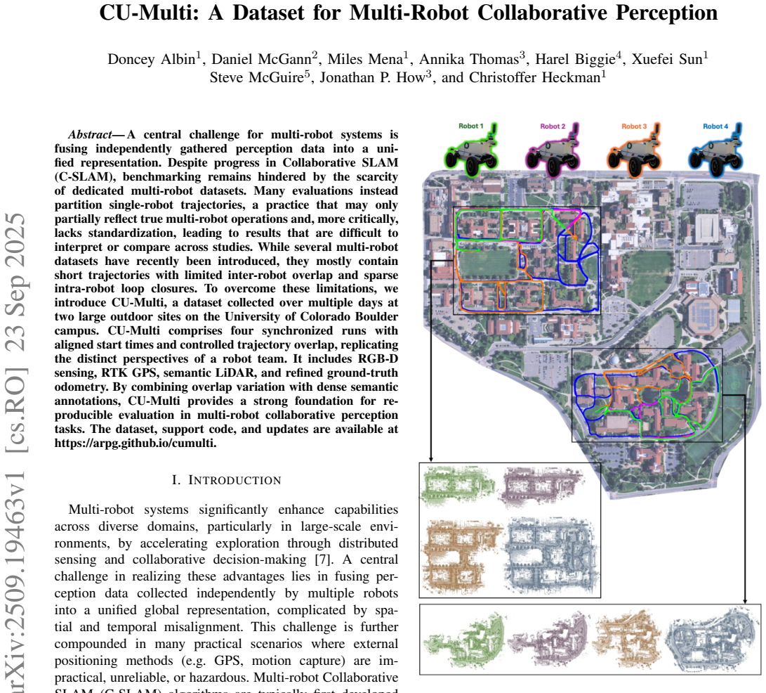
The central contribution is the dataset itself: four LiDAR trajectories per environment, totaling 16.7 km of traversed path, designed so that robot1 and robot2 share significant overlap, robot3 extends their union, and robot4 covers the whole area—expressed as T1≈T2, (T1∪T2)⊆T3, (T1∪T2∪T3)⊆T4. Ground truth is computed offline by optimizing a factor graph that fuses GPS from two receivers, LiDAR-inertial odometry from LIO-SAM and CT-ICP, IMU, digital-elevation-model priors, and a fixed start chock prior, yielding a pose at every LiDAR timestamp. The paper also provides an automated two-stage LiDAR semantic labeling pipeline (zero-shot CENet predictions refined with OpenStreetMap features) and
Load-bearing premise
The dataset's validity as a multi-robot benchmark assumes that replaying a single robot's runs with a 200-second time offset faithfully represents a team of independently operating robots, including their distinct viewpoints and communication scenarios.
Editorial extensions
If this is right
- C-SLAM algorithms can be evaluated under controlled overlap levels, from high redundancy (robot1/robot2) to sparse overlap (robot1/robot4), with ground truth for quantitative comparison.
- The dataset supports multi-session and multi-robot place recognition benchmarking, as demonstrated by ScanContext precision-recall curves.
- The trajectory clipper allows researchers to create custom playback overlap scenarios, including distance-based communication constraints, without recollecting data.
- Semantically labeled LiDAR makes the dataset usable for multi-robot semantic perception tasks such as semantic mapping and label transfer.
- The ground-truth poses, computed at LiDAR frequency, allow metric evaluation of ATE and RPE for distributed SLAM systems.
Reading between the lines
- Because the runs come from one physical platform replayed with a 200 s offset, the dataset cannot capture per-robot sensor bias, calibration drift, or the effects of simultaneous radio communication; real heterogeneous teams may exhibit different failure modes. A natural next step is a true multi-platform collection preserving the same overlap design.
- The controlled-overlap design could be used to systematically probe the robustness of inter-robot loop-closure verification methods, mapping accuracy vs. overlap fraction and measuring the time-to-first closure as a function of spatial redundancy.
- The dataset's ground-truth refinement methodology—factor-graph fusion of GPS, LiDAR odometry, IMU, and DEM priors—could be repurposed as a standalone tool for creating high-frequency global ground truth for any outdoor robot dataset.
- The semantic labels are produced automatically and may inherit CENet's class ontology and errors; downstream users should validate label quality in regions where OSM features are sparse or outdated.
Editorial analysis
A structured set of objections, weighed in public.
Referee Report
Summary. CU-Multi is introduced as a multi-robot collaborative perception dataset collected at two large outdoor sites on the CU Boulder campus. It consists of four runs per environment, eight trajectories total, with RGB-D, 64-beam LiDAR, RTK GPS, IMU, and refined ground-truth poses. The runs were collected with a single ground robot over separate sessions and are later replayed with a 200 s offset to simulate multi-robot operation. The paper describes a factor-graph ground-truth pipeline using GPS, a digital elevation model, LIO-SAM, and CT-ICP, an automated zero-shot LiDAR semantic labeling pipeline, and a trajectory clipper tool. Demonstrations include ScanContext place recognition precision-recall curves and DiSCo-SLAM ATE/RPE results.
Significance. The dataset addresses a real need: long, large outdoor trajectories with controlled overlap and LiDAR semantics for collaborative perception evaluation. The trajectory design with rendezvous-style endings and variable overlap is sensible, and the release of support code, converters, and a trajectory clipper is a practical contribution. If the stated claims are supported, the dataset would be a useful benchmark resource complementing existing multi-robot datasets. However, the central 'multi-robot' framing is currently overstated given that all data come from one platform replayed asynchronously, and key quality claims on semantics and ground truth lack quantitative validation. These issues are fixable but require substantive revision.
major comments (4)
- [Section III.A and IV.B] The dataset is collected with a single robotic platform over separate sessions (Section III.A), and the C-SLAM demonstration uses a 200 s playback offset (Section IV.B). The abstract's 'four synchronized runs' and the paper's 'multi-robot dataset' framing therefore rest on post-hoc replay of one platform rather than simultaneous operation of independent robots. This cannot capture inter-robot effects such as distinct sensor noise characteristics, simultaneous dynamic obstacles, or true communication constraints. This concern is especially relevant because the paper itself criticizes trajectory-splitting in Section II.B; replays of the same platform with an offset are closer to multi-session evaluation than to genuine multi-robot evaluation. The authors should either reframe CU-Multi as a multi-session dataset with a replay-based benchmark, or substantially qualify the multi-robot claims,
- [Section III.D] The semantic labels are generated by a zero-shot pipeline (CENet) with OSM-based refinement, but no validation against human labels or an independent benchmark is reported. The abstract and introduction refer to 'dense semantic annotations' and 'annotated LiDAR' as a key feature; without accuracy assessment, these labels cannot be regarded as ground-truth semantics. A subset validation with human labels or a quantitative comparison (e.g., IoU against SemanticKITTI or a manually labeled subset) is necessary to support the semantic annotation claim.
- [Section IV.B and Table II] Table II reports ATE and RPE averages only for runs that 'remained stable'; one of four env1 runs and two of five env2 runs diverged due to erroneous loop closures. This means 3 of 9 DiSCo-SLAM trials failed, and the table omits this failure information. Reporting only the successful averages overstates the method's performance and the dataset's usability for C-SLAM benchmarking. The authors should report per-run results, include the failure count, and discuss the causes of divergence. The current presentation does not support the Section IV.C conclusion that the dataset is 'the right substrate' for evaluation.
- [Section III.C] The ground-truth pose accuracy is never quantified. The factor-graph solution combines GPS, DEM, LIO-SAM, and CT-ICP, but no validation is given for the resulting poses (e.g., comparison to independent RTK in open areas, loop-closure residuals, or leave-one-out analysis). Since these poses are used for all benchmark metrics, readers need at least approximate accuracy bounds or an external validation to trust the ATE/RPE and PR evaluations.
minor comments (6)
- [Section III.C] There are typos: 'groundruth' instead of 'ground truth' appears twice in the text. Please proofread.
- [Throughout] Inconsistent spelling of 'DiSCo-SLAM' vs. 'DiSCO-SLAM'; pick one and use consistently.
- [Section III.E] Equation (1) uses T_i without explicitly defining the notation before the equation; it is clear from context but should be stated.
- [Figure 6] The environment names 'env1' and 'env2' are used in the text, but Figure 6 labels 'Main Campus' and 'Kittredge Loop'; clarify the correspondence.
- [Section III.D] The phrase 'at the heart of [6]' is awkward and likely means 'in the spirit of [6]'.
- [Section IV.C] 'time-to-first closure' is mentioned but not defined or reported; either define and present it or remove the mention.
Circularity Check
No significant circularity: dataset construction, ground truth, and benchmarks are self-contained; the single-platform replay is a representativeness caveat, not a circular derivation.
full rationale
CU-Multi is a data-collection paper rather than a derivation paper; there are no fitted parameters being relabeled as predictions. Ground-truth poses are produced by an independent factor-graph optimization over RTK GPS, DEM priors, LIO-SAM, CT-ICP, and IMU measurements (Section III.C), none of which are outputs of the evaluated ScanContext or DiSCo-SLAM baselines. The ScanContext precision-recall evaluation (Section IV.A) and DiSCo-SLAM ATE/RPE results (Section IV.B) are standard benchmark measurements with stated parameters and released code; no quantity is defined in terms of the benchmark output. The only potentially problematic element is the 'multi-robot' labeling of data collected with a single platform replayed with a 200 s offset (Sections III.A and IV.A), but this is an explicitly disclosed methodological proxy and a question of external validity, not a circular reduction of a derivation to its input. The self-citations to Kimera-Multi [2],[26] are merely comparative Table I entries and are not load-bearing for any claim. Therefore no circularity step meets the required evidentiary standard.
Assumptions & free parameters
assumptions (3)
- domain assumption CENet zero-shot predictions plus OSM-based filtering produce annotations accurate enough to be called semantic LiDAR or dense semantic annotations.
- domain assumption The factor-graph solution (RTK GPS, DEM priors, LIO-SAM, CT-ICP, IMU, chock priors) yields ground-truth poses accurate enough for benchmarking at each LiDAR timestamp.
- ad hoc to paper A single platform re-run on multiple sessions, with time offsets, is a valid proxy for a team of independent robots in C-SLAM evaluation.
Cite this review
Pith. "Pith review of CU-Multi: A Dataset for Multi-Robot Collaborative Perception." pith.science (2026). https://pith.science/paper/OLKNW43S
@misc{pith2026250919463,
  author       = {Pith},
  title        = {Pith review of: CU-Multi: A Dataset for Multi-Robot Collaborative Perception},
  year         = {2026},
  howpublished = {\url{https://pith.science/paper/OLKNW43S}},
  note         = {Machine review of arXiv:2509.19463}
}
read the original abstract
A central challenge for multi-robot systems is fusing independently gathered perception data into a unified representation. Despite progress in Collaborative SLAM (C-SLAM), benchmarking remains hindered by the scarcity of dedicated multi-robot datasets. Many evaluations instead partition single-robot trajectories, a practice that may only partially reflect true multi-robot operations and, more critically, lacks standardization, leading to results that are difficult to interpret or compare across studies. While several multi-robot datasets have recently been introduced, they mostly contain short trajectories with limited inter-robot overlap and sparse intra-robot loop closures. To overcome these limitations, we introduce CU-Multi, a dataset collected over multiple days at two large outdoor sites on the University of Colorado Boulder campus. CU-Multi comprises four synchronized runs with aligned start times and controlled trajectory overlap, replicating the distinct perspectives of a robot team. It includes RGB-D sensing, RTK GPS, semantic LiDAR, and refined ground-truth odometry. By combining overlap variation with dense semantic annotations, CU-Multi provides a strong foundation for reproducible evaluation in multi-robot collaborative perception tasks.
Figures


Figures from the paper (8 more)


Reference graph
Works this paper leans on
-
[1]
GRACO: A multimodal dataset for ground and aerial cooperative localization and mapping,
Y . Zhu, Y . Kong, Y . Jie, S. Xu, and H. Cheng, “GRACO: A multimodal dataset for ground and aerial cooperative localization and mapping,” IEEE Robotics and Automation Letters, vol. 8, no. 2, pp. 966–973, 2023
2023
-
[2]
Resilient and distributed multi-robot visual SLAM: Datasets, experiments, and lessons learned,
Y . Tian, Y . Chang, L. Quang, A. Schang, C. Nieto-Granda, J. P. How, and L. Carlone, “Resilient and distributed multi-robot visual SLAM: Datasets, experiments, and lessons learned,” 2023
2023
-
[3]
S3E: A Multi-Robot Multimodal Dataset for Collaborative SLAM,
D. Feng, Y . Qi, S. Zhong, Z. Chen, Q. Chen, H. Chen, J. Wu, and J. Ma, “S3E: A Multi-Robot Multimodal Dataset for Collaborative SLAM,”IEEE Robotics and Automation Letters, 2024
2024
-
[4]
J. Kim, H. Kim, S. Jeong, Y . Shin, and Y . Cho, “DiTer++: Diverse Terrain and Multi-modal Dataset for Multi-Robot SLAM in Multi- session Environments,”arXiv preprint arXiv:2412.05839, 2024
arXiv 2024
-
[5]
LAMP 2.0: A robust multi-robot SLAM system for operation in challenging large-scale underground environments,
Y . Chang, K. Ebadi, C. E. Denniston, M. F. Ginting, A. Rosinol, A. Reinke, M. Palieri, J. Shi, A. Chatterjee, B. Morrellet al., “LAMP 2.0: A robust multi-robot SLAM system for operation in challenging large-scale underground environments,”IEEE Robotics and Automation Letters, vol. 7, no. 4, pp. 9175–9182, 2022
2022
-
[6]
CoPeD- Advancing Multi-Robot Collaborative Perception: A Comprehensive Dataset in Real-World Environments,
Y . Zhou, L. Quang, C. Nieto-Granda, and G. Loianno, “CoPeD- Advancing Multi-Robot Collaborative Perception: A Comprehensive Dataset in Real-World Environments,”IEEE Robotics and Automation Letters, 2024
2024
-
[7]
Multi-robot multi-room exploration with geometric cue extraction and circular decomposition,
S. Kim, M. Corah, J. Keller, G. Best, and S. Scherer, “Multi-robot multi-room exploration with geometric cue extraction and circular decomposition,”IEEE Robotics and Automation Letters, vol. 9, no. 2, pp. 1190–1197, 2023
2023
-
[8]
DCL- SLAM: A distributed collaborative lidar SLAM framework for a robotic swarm,
S. Zhong, Y . Qi, Z. Chen, J. Wu, H. Chen, and M. Liu, “DCL- SLAM: A distributed collaborative lidar SLAM framework for a robotic swarm,”IEEE sensors journal, vol. 24, no. 4, pp. 4786–4797, 2023
2023
Show all 32 references
-
[9]
Swarm-slam: Sparse decentralized collaborative simultaneous localization and mapping framework for multi-robot systems,
P.-Y . Lajoie and G. Beltrame, “Swarm-slam: Sparse decentralized collaborative simultaneous localization and mapping framework for multi-robot systems,”IEEE Robotics and Automation Letters, vol. 9, no. 1, pp. 475–482, 2023
2023
-
[10]
Towards collabo- rative simultaneous localization and mapping: a survey of the current research landscape,
P.-Y . Lajoie, B. Ramtoula, F. Wu, and G. Beltrame, “Towards collabo- rative simultaneous localization and mapping: a survey of the current research landscape,”Field Robotics, vol. 2, pp. 971–1000, 2022
2022
-
[11]
Vision meets robotics: The kitti dataset,
A. Geiger, P. Lenz, C. Stiller, and R. Urtasun, “Vision meets robotics: The kitti dataset,”The International Journal of Robotics Research, vol. 32, no. 11, pp. 1231–1237, 2013
2013
-
[12]
Semantickitti: A dataset for semantic scene un- derstanding of lidar sequences,
J. Behley, M. Garbade, A. Milioto, J. Quenzel, S. Behnke, C. Stach- niss, and J. Gall, “Semantickitti: A dataset for semantic scene un- derstanding of lidar sequences,” inProceedings of the IEEE/CVF international conference on computer vision, 2019, pp. 9297–9307
2019
-
[13]
Kitti-360: A novel dataset and benchmarks for urban scene understanding in 2D and 3D,
Y . Liao, J. Xie, and A. Geiger, “Kitti-360: A novel dataset and benchmarks for urban scene understanding in 2D and 3D,”IEEE Transactions on Pattern Analysis and Machine Intelligence, vol. 45, no. 3, pp. 3292–3310, 2022
2022
-
[14]
Efficient decentralized visual place recognition using a distributed inverted index,
T. Cieslewski and D. Scaramuzza, “Efficient decentralized visual place recognition using a distributed inverted index,”IEEE Robotics and Automation Letters, vol. 2, no. 2, pp. 640–647, 2017
2017
-
[15]
Data-efficient decentralized visual SLAM,
T. Cieslewski, S. Choudhary, and D. Scaramuzza, “Data-efficient decentralized visual SLAM,” in2018 IEEE international conference on robotics and automation (ICRA). IEEE, 2018, pp. 2466–2473
2018
-
[16]
DOOR-SLAM: Distributed, online, and outlier resilient SLAM for robotic teams,
P.-Y . Lajoie, B. Ramtoula, Y . Chang, L. Carlone, and G. Beltrame, “DOOR-SLAM: Distributed, online, and outlier resilient SLAM for robotic teams,”IEEE Robotics and Automation Letters, vol. 5, no. 2, pp. 1656–1663, 2020
2020
-
[17]
DiSCo-SLAM: Dis- tributed scan context-enabled multi-robot lidar SLAM with two- stage global-local graph optimization,
Y . Huang, T. Shan, F. Chen, and B. Englot, “DiSCo-SLAM: Dis- tributed scan context-enabled multi-robot lidar SLAM with two- stage global-local graph optimization,”IEEE Robotics and Automation Letters, vol. 7, no. 2, pp. 1150–1157, 2021
2021
-
[18]
RDC- SLAM: A real-time distributed cooperative SLAM system based on 3D lidar,
Y . Xie, Y . Zhang, L. Chen, H. Cheng, W. Tu, D. Cao, and Q. Li, “RDC- SLAM: A real-time distributed cooperative SLAM system based on 3D lidar,”IEEE Transactions on Intelligent Transportation Systems, vol. 23, no. 9, pp. 14 721–14 730, 2021
2021
-
[19]
Wi- closure: Reliable and efficient search of inter-robot loop closures using wireless sensing,
W. Wang, A. Kemmeren, D. Son, J. Alonso-Mora, and S. Gil, “Wi- closure: Reliable and efficient search of inter-robot loop closures using wireless sensing,” in2023 IEEE International Conference on Robotics and Automation (ICRA). IEEE, 2023, pp. 2069–2075
2023
-
[20]
FRAME: a modular framework for au- tonomous map-merging: Advancements in the field,
N. Stathoulopoulos, B. Lindqvist, A. Koval, A.-A. Agha-Mohammadi, and G. Nikolakopoulos, “FRAME: a modular framework for au- tonomous map-merging: Advancements in the field,”IEEE Transac- tions on Field Robotics, 2024
2024
-
[21]
Slideslam: Sparse, lightweight, de- centralized metric-semantic SLAM for multi-robot navigation,
X. Liu, J. Lei, A. Prabhu, Y . Tao, I. Spasojevic, P. Chaudhari, N. Atanasov, and V . Kumar, “Slideslam: Sparse, lightweight, de- centralized metric-semantic SLAM for multi-robot navigation,”arXiv preprint arXiv:2406.17249, 2024
2024
-
[22]
Multi-robot object SLAM using distributed variational inference,
H. Cao, S. Shreedharan, and N. Atanasov, “Multi-robot object SLAM using distributed variational inference,”IEEE Robotics and Automa- tion Letters, 2024
2024
-
[23]
The UTIAS multi-robot cooperative localization and mapping dataset,
K. Y . Leung, Y . Halpern, T. D. Barfoot, and H. H. Liu, “The UTIAS multi-robot cooperative localization and mapping dataset,”The International Journal of Robotics Research, vol. 30, no. 8, pp. 969– 974, 2011
2011
-
[24]
Ford multi-av seasonal dataset,
S. Agarwal, A. V ora, G. Pandey, W. Williams, H. Kourous, and J. McBride, “Ford multi-av seasonal dataset,”The International Jour- nal of Robotics Research, vol. 39, no. 12, pp. 1367–1376, 2020
2020
-
[25]
AirMuseum: a heterogeneous multi-robot dataset for stereo-visual and inertial simultaneous local- ization and mapping,
R. Dubois, A. Eudes, and V . Fr ´emont, “AirMuseum: a heterogeneous multi-robot dataset for stereo-visual and inertial simultaneous local- ization and mapping,” in2020 IEEE International Conference on Multisensor Fusion and Integration for Intelligent Systems (MFI). IEEE, 2020...
2020
-
[26]
Kimera-multi: Robust, distributed, dense metric-semantic SLAM for multi-robot systems,
Y . Tian, Y . Chang, F. H. Arias, C. Nieto-Granda, J. P. How, and L. Carlone, “Kimera-multi: Robust, distributed, dense metric-semantic SLAM for multi-robot systems,”IEEE Transactions on Robotics, vol. 38, no. 4, 2022
2022
-
[27]
LIO-SAM: Tightly-coupled lidar inertial odometry via smoothing and mapping,
T. Shan, B. Englot, D. Meyers, W. Wang, C. Ratti, and R. Daniela, “LIO-SAM: Tightly-coupled lidar inertial odometry via smoothing and mapping,” inIEEE/RSJ International Conference on Intelligent Robots and Systems (IROS). IEEE, 2020, pp. 5135–5142
2020
-
[28]
CT- ICP: real-time elastic lidar odometry with loop closure,
P. Dellenbach, J.-E. Deschaud, B. Jacquet, and F. Goulette, “CT- ICP: real-time elastic lidar odometry with loop closure,” in2022 International Conference on Robotics and Automation (ICRA). IEEE, 2022, pp. 5580–5586
2022
-
[29]
USGS 1 meter 13 x47y443 CO DRCOG 2020 B20,
U.S. Geological Survey, “USGS 1 meter 13 x47y443 CO DRCOG 2020 B20,” 2022, www.sciencebase.gov/catalog/ item/620de541d34e6c7e83baa08a
2020
-
[30]
Factor graphs and GTSAM: A hands-on introduction,
F. Dellaert, “Factor graphs and GTSAM: A hands-on introduction,” Georgia Institute of Technology, Technical Report, 2012
2012
-
[31]
Cenet: Toward concise and efficient lidar semantic segmentation for autonomous driving,
H.-X. Cheng, X.-F. Han, and G.-Q. Xiao, “Cenet: Toward concise and efficient lidar semantic segmentation for autonomous driving,” in 2022 IEEE International Conference on Multimedia and Expo (ICME). IEEE, 2022, pp. 01–06
2022
-
[32]
Scan context: Egocentric spatial descriptor for place recognition within 3D point cloud map,
G. Kim and A. Kim, “Scan context: Egocentric spatial descriptor for place recognition within 3D point cloud map,” in2018 IEEE/RSJ International Conference on Intelligent Robots and Systems (IROS). IEEE, 2018, pp. 4802–4809
2018
Reviewed August 4, 2026 · model on record in the stance chip above.
Discussion (0). Continue with ORCID to comment.