AUSLUN: A Fixed-Hover UAV--USV System for GNSS-Denied Maritime Search and Navigation
Pith reviewed 2026-06-30 06:03 UTC · model grok-4.3
The pith
A fixed-hover UAV using visual-inertial odometry can anchor USV search and navigation to a stationary target without GNSS in coastal waters.
A machine-rendered reading of the paper's core claim, the machinery that carries it, and where it could break.
Core claim
The central claim is that a coastal UAV that hovers in place, estimates its pose through visual-inertial odometry, and uses a zoom pod for annular scanning can serve as a long-range sensing and navigation anchor for a USV by coupling polygon-aware search, modality-aware bearing-range localization, target-relative guidance, and visual-loss recovery, with the same gated recursive estimator handling both laser and datalink range data.
What carries the argument
The fixed-hover UAV with zoom pod that performs polygon-aware annular pod scanning, modality-aware bearing-range localization, and gated recursive estimation of range measurements.
If this is right
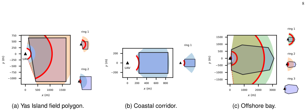
- Adaptive yaw bounds reduce both scan time and redundant coverage relative to matched fixed-sector scans.
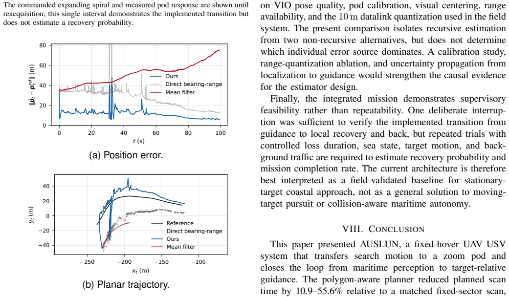
- The gated recursive estimator outperforms non-recursive baselines in localization accuracy on GPS-referenced field data.
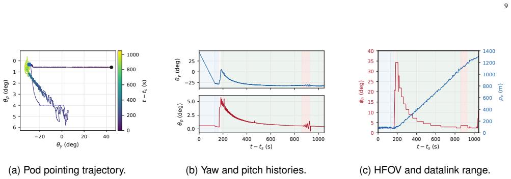
- The integrated pipeline completes the full search-to-navigation sequence, including recovery from deliberate visual loss.
- Fixed-hover UAV assistance has a measurable operating boundary for stationary-target approach in coastal GNSS-denied settings.
Where Pith is reading between the lines
- The same fixed-hover anchor principle could be tested with moving targets if the estimator is extended to predict target motion.
- Drift accumulation during longer hovers might be mitigated by periodic visual re-registration against known coastal features.
- Multiple such UAV anchors could be coordinated to enlarge the searchable area without increasing individual hover duration.
Load-bearing premise
Visual-inertial odometry on the UAV supplies sufficiently accurate and low-drift pose estimates while the platform maintains a fixed hover over the sea.
What would settle it
A maritime field test in which UAV visual-inertial odometry drift exceeds the tolerance needed for the USV to reach the localized target position.
Figures


read the original abstract
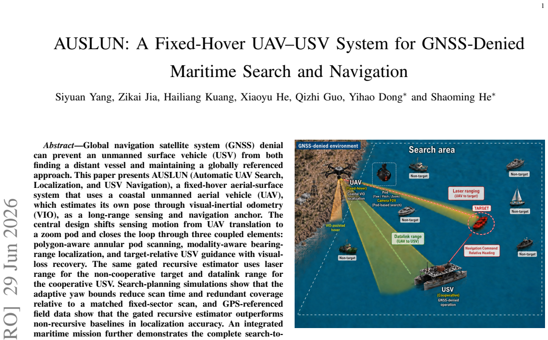
Global navigation satellite system (GNSS) denial can prevent an unmanned surface vehicle (USV) from both finding a distant vessel and maintaining a globally referenced approach. This paper presents AUSLUN (Automatic UAV Search, Localization, and USV Navigation), a fixed-hover aerial-surface system that uses a coastal unmanned aerial vehicle (UAV), which estimates its own pose through visual-inertial odometry (VIO), as a long-range sensing and navigation anchor. The central design shifts sensing motion from UAV translation to a zoom pod and closes the loop through three coupled elements: polygon-aware annular pod scanning, modality-aware bearing-range localization, and target-relative USV guidance with visual-loss recovery. The same gated recursive estimator uses laser range for the non-cooperative target and datalink range for the cooperative USV. Search-planning simulations show that the adaptive yaw bounds reduce scan time and redundant coverage relative to a matched fixed-sector scan, and GPS-referenced field data show that the gated recursive estimator outperforms non-recursive baselines in localization accuracy. An integrated maritime mission further demonstrates the complete search-to-navigation sequence, including a deliberately triggered visual-loss recovery. These results establish the feasibility and operating boundary of fixed-hover UAV assistance for stationary-target approach in coastal GNSS-denied environments. The source code and a video demonstration are publicly available at https://github.com/xirhxq/pod_search and https://youtu.be/S-5RkJs35JI.
Editorial analysis
A structured set of objections, weighed in public.
Referee Report
Summary. The paper presents AUSLUN, a fixed-hover UAV-USV system for GNSS-denied maritime search and navigation. A coastal UAV maintains fixed hover while using VIO for self-pose estimation and a zoom pod for polygon-aware annular scanning to detect and localize a stationary target. Localization employs a modality-aware gated recursive estimator that fuses laser range (non-cooperative target) or datalink range (cooperative USV) with bearing measurements. Target-relative USV guidance includes visual-loss recovery. Search-planning simulations show adaptive yaw bounds reduce scan time versus fixed-sector scans; GPS-referenced field tests show the estimator outperforms non-recursive baselines in accuracy; an integrated mission demonstrates the full sequence. Public code and video are provided. The results claim to establish feasibility and operating boundaries for fixed-hover UAV assistance in coastal GNSS-denied settings.
Significance. If the central claims hold, the work demonstrates a practical architecture for UAV-assisted USV navigation without direct GNSS by shifting sensing motion to a pod and closing the loop with coupled scanning, estimation, and guidance. The public release of source code and video demonstration is a clear strength, supporting reproducibility. This could enable new capabilities in maritime robotics for search, rescue, or autonomous approach in GNSS-denied coastal zones.
major comments (1)
- [Field experiments / results] § on field experiments / results: GPS-referenced data validates the gated recursive estimator's localization accuracy but supplies no VIO-specific error statistics, drift rates, or ablation studies under fixed-hover conditions over low-texture sea surfaces. This directly undermines the load-bearing assumption that VIO supplies sufficiently accurate, low-drift pose estimates to serve as the navigation anchor (see also abstract claim on VIO as long-range sensing anchor).
minor comments (2)
- [Abstract] Abstract: quantitative metrics (e.g., scan-time reduction factor, localization RMSE values) are stated only qualitatively; adding explicit numbers would improve clarity of the performance claims.
- [System design] Notation: ensure consistent definition of bearing and range variables when switching between laser and datalink modalities across the system description.
Simulated Author's Rebuttal
We thank the referee for the constructive feedback on the field experiments. The comment correctly identifies a gap in VIO-specific reporting, which we address below by agreeing to strengthen the manuscript with available data analysis.
read point-by-point responses
-
Referee: [Field experiments / results] § on field experiments / results: GPS-referenced data validates the gated recursive estimator's localization accuracy but supplies no VIO-specific error statistics, drift rates, or ablation studies under fixed-hover conditions over low-texture sea surfaces. This directly undermines the load-bearing assumption that VIO supplies sufficiently accurate, low-drift pose estimates to serve as the navigation anchor (see also abstract claim on VIO as long-range sensing anchor).
Authors: We agree the manuscript does not report explicit VIO error statistics, drift rates, or ablations under fixed-hover over low-texture sea. The GPS-referenced tests validate the end-to-end localization and guidance pipeline (which depends on VIO pose), and the integrated mission succeeded with visual-loss recovery, providing indirect evidence that VIO drift remained within operational bounds for the demonstrated ranges. However, this does not substitute for direct VIO metrics. We will revise the field-experiments section to include VIO-specific statistics and drift rates extracted from the existing GPS-referenced logs (where ground-truth UAV pose is available via GPS), plus a brief discussion of operating boundaries. If data permits, a limited ablation on VIO contribution will be added. This directly addresses the load-bearing assumption without requiring new experiments. revision: yes
Circularity Check
No circularity; claims rest on external simulations and field measurements
full rationale
The abstract and description present a system design whose performance claims are supported by search-planning simulations and GPS-referenced field data for the gated recursive estimator. No equations, parameters, or results are shown to be defined in terms of themselves or renamed as predictions. No self-citations appear as load-bearing justifications. The VIO assumption is stated as an input rather than derived from the paper's outputs, so the derivation chain does not reduce to its inputs by construction.
Axiom & Free-Parameter Ledger
axioms (1)
- domain assumption Visual-inertial odometry supplies sufficiently accurate and low-drift pose estimates for a fixed-hover UAV in coastal maritime conditions
Reference graph
Works this paper leans on
-
[1]
Dynamic guarding of marine assets through cluster control of automated surface vessel fleets,
P. Mahacek, C. A. Kitts, and I. A. Mas, “Dynamic guarding of marine assets through cluster control of automated surface vessel fleets,” IEEE/ASME Transactions on Mechatronics, vol. 17, no. 1, pp. 65–75, 2012
2012
-
[2]
Path-following with LiDAR- based obstacle avoidance of an unmanned surface vehicle in harbor conditions,
J. Villa, J. Aaltonen, and K. T. Koskinen, “Path-following with LiDAR- based obstacle avoidance of an unmanned surface vehicle in harbor conditions,”IEEE/ASME Transactions on Mechatronics, vol. 25, no. 4, pp. 1812–1820, 2020
2020
-
[3]
Trusted multisource fusion navigation for UA V under GNSS interference and spoofing attacks,
C. Meng, Q. Hu, S. S. Ge, and D. Li, “Trusted multisource fusion navigation for UA V under GNSS interference and spoofing attacks,” IEEE/ASME Transactions on Mechatronics, vol. 30, no. 6, pp. 4165– 4175, 2025
2025
-
[4]
LVI-SAM: Tightly-coupled LiDAR-visual-inertial odometry via smoothing and mapping,
T. Shan, B. Englot, C. Ratti, and D. Rus, “LVI-SAM: Tightly-coupled LiDAR-visual-inertial odometry via smoothing and mapping,” in2021 IEEE International Conference on Robotics and Automation (ICRA), 2021, pp. 5692–5698
2021
-
[5]
Visual inertial odometry swarm: An autonomous swarm of vision-based quadrotors,
A. Weinstein, A. Cho, and G. Loianno, “Visual inertial odometry swarm: An autonomous swarm of vision-based quadrotors,”IEEE Robotics and Automation Letters, vol. 3, no. 4, pp. 1801–1807, 2018
2018
-
[6]
Sensor-driven online coverage planning for autonomous underwater vehicles,
L. Paull, S. Saeedi, M. Seto, and H. Li, “Sensor-driven online coverage planning for autonomous underwater vehicles,”IEEE/ASME Transac- tions on Mechatronics, vol. 18, no. 6, pp. 1827–1838, 2013
2013
-
[7]
Active SLAM for mobile robots with area coverage and obstacle avoidance,
Y . Chen, S. Huang, and R. Fitch, “Active SLAM for mobile robots with area coverage and obstacle avoidance,”IEEE/ASME Transactions on Mechatronics, vol. 25, no. 3, pp. 1182–1192, 2020
2020
-
[8]
Input saturated visual servoing for unmanned aerial vehicles,
H. Xie and A. F. Lynch, “Input saturated visual servoing for unmanned aerial vehicles,”IEEE/ASME Transactions on Mechatronics, vol. 22, no. 2, pp. 952–960, 2017
2017
-
[9]
Toward visibility guaranteed visual servoing control of quadrotor UA Vs,
D. Zheng, H. Wang, J. Wang, X. Zhang, and W. Chen, “Toward visibility guaranteed visual servoing control of quadrotor UA Vs,”IEEE/ASME Transactions on Mechatronics, vol. 24, no. 3, pp. 1087–1095, 2019
2019
-
[10]
Robocentric model-based visual ser- voing for quadrotor flights,
Y . Li, G. Lu, D. He, and F. Zhang, “Robocentric model-based visual ser- voing for quadrotor flights,”IEEE/ASME Transactions on Mechatronics, vol. 28, no. 4, pp. 2155–2166, 2023
2023
-
[11]
Perception-aware image- based visual servoing of aggressive quadrotor UA Vs,
C. Qin, Q. Yu, H. S. H. Go, and H. H.-T. Liu, “Perception-aware image- based visual servoing of aggressive quadrotor UA Vs,”IEEE/ASME Transactions on Mechatronics, vol. 28, no. 4, pp. 2020–2028, 2023
2020
-
[12]
Mohamed Bin Zayed International Robotics Challenge 2023,
“Mohamed Bin Zayed International Robotics Challenge 2023,” 2023, accessed: Jun. 15, 2026. [Online]. Available: https://www.mbzirc.com
2023
-
[13]
A survey on coverage path planning for robotics,
E. Galceran and M. Carreras, “A survey on coverage path planning for robotics,”Robotics and Autonomous Systems, vol. 61, no. 12, pp. 1258– 1276, 2013
2013
-
[14]
2D visual area coverage and path planning coupled with camera footprints,
S. S. Mansouri, C. Kanellakis, G. Georgoulas, D. Kominiak, T. Gustafs- son, and G. Nikolakopoulos, “2D visual area coverage and path planning coupled with camera footprints,”Control Engineering Practice, vol. 75, pp. 1–16, 2018
2018
-
[15]
A simulation framework for zoom-aided coverage path planning with UA V-mounted PTZ cameras,
N. C. Rios, S. Mondal, and A. Tsourdos, “A simulation framework for zoom-aided coverage path planning with UA V-mounted PTZ cameras,” Sensors, vol. 25, no. 17, p. 5220, 2025
2025
-
[16]
Integrated guidance and gimbal control for coverage planning with visibility constraints,
S. Papaioannou, P. Kolios, T. Theocharides, C. G. Panayiotou, and M. M. Polycarpou, “Integrated guidance and gimbal control for coverage planning with visibility constraints,”IEEE Transactions on Aerospace and Electronic Systems, vol. 59, no. 2, pp. 1276–1291, 2023
2023
-
[17]
Coverage path planning for maritime search and rescue using reinforcement learning,
B. Ai, M. Jia, H. Xu, J. Xu, Z. Wen, B. Li, and D. Zhang, “Coverage path planning for maritime search and rescue using reinforcement learning,” Ocean Engineering, vol. 241, p. 110098, 2021
2021
-
[18]
A survey of maritime unmanned search system: Theory, applications and future directions,
J. Li, G. Zhang, C. Jiang, and W. Zhang, “A survey of maritime unmanned search system: Theory, applications and future directions,” Ocean Engineering, vol. 285, p. 115359, 2023
2023
-
[19]
Cooperative localization of marine targets by UA Vs,
S. M. Esmailifar and F. Saghafi, “Cooperative localization of marine targets by UA Vs,”Mechanical Systems and Signal Processing, vol. 87, pp. 23–42, 2017
2017
-
[20]
A VIO-based local- ization approach in GPS-denied environments for an unmanned surface vehicle,
X. Liu, Z. Hu, Z. Sun, J. Lu, W. Xie, and W. Zhang, “A VIO-based local- ization approach in GPS-denied environments for an unmanned surface vehicle,” in2023 International Conference on Advanced Robotics and Mechatronics (ICARM), 2023, pp. 912–917
2023
-
[21]
Coastal SLAM with marine radar for USV operation in GPS-restricted situations,
J. Han, Y . Cho, and J. Kim, “Coastal SLAM with marine radar for USV operation in GPS-restricted situations,”IEEE Journal of Oceanic Engineering, vol. 44, no. 2, pp. 300–309, 2019
2019
-
[22]
A LiDAR SLAM-assisted fusion positioning method for USVs,
W. Shen, Z. Yang, C. Yang, and X. Li, “A LiDAR SLAM-assisted fusion positioning method for USVs,”Sensors, vol. 23, no. 3, p. 1558, 2023
2023
-
[23]
Vision-based positioning system for auto-docking of unmanned surface vehicles (USVs),
Ø. V olden, A. Stahl, and T. I. Fossen, “Vision-based positioning system for auto-docking of unmanned surface vehicles (USVs),”International Journal of Intelligent Robotics and Applications, vol. 6, no. 1, pp. 86– 103, 2022
2022
-
[24]
Asymp- totically efficient estimator for range-based robot relative localization,
Y . Wang, M. Lin, X. Xie, Y . Gao, F. Deng, and T. L. Lam, “Asymp- totically efficient estimator for range-based robot relative localization,” IEEE/ASME Transactions on Mechatronics, vol. 28, no. 6, pp. 3525– 3536, 2023
2023
-
[25]
Coordinated trajectory-tracking control of a marine aerial-surface heterogeneous system,
N. Wang and C. K. Ahn, “Coordinated trajectory-tracking control of a marine aerial-surface heterogeneous system,”IEEE/ASME Transactions on Mechatronics, vol. 26, no. 6, pp. 3198–3210, 2021
2021
-
[26]
Visual pose estimation of rescue unmanned surface vehicle from unmanned aerial system,
J. Dufek and R. Murphy, “Visual pose estimation of rescue unmanned surface vehicle from unmanned aerial system,”Frontiers in Robotics and AI, vol. 6, p. 42, 2019
2019
-
[27]
Cooperative USV–UA V marine search and rescue with visual navigation and reinforcement learning- based control,
Y . Wang, W. Liu, J. Liu, and C. Sun, “Cooperative USV–UA V marine search and rescue with visual navigation and reinforcement learning- based control,”ISA Transactions, vol. 137, pp. 222–235, 2023
2023
-
[28]
A USV-UA V cooperative trajectory planning algorithm with hull dynamic constraints,
T. Huang, Z. Chen, W. Gao, Z. Xue, and Y . Liu, “A USV-UA V cooperative trajectory planning algorithm with hull dynamic constraints,” Sensors, vol. 23, no. 4, p. 1845, 2023
2023
-
[29]
Real-time multi-target localization from unmanned aerial vehicles,
X. Wang, J. Liu, and Q. Zhou, “Real-time multi-target localization from unmanned aerial vehicles,”Sensors, vol. 17, no. 1, p. 33, 2017
2017
-
[30]
Accurate and real-time 3-D tracking for the following robots by fusing vision and ultrasonar information,
M. Wang, Y . Liu, D. Su, Y . Liao, L. Shi, J. Xu, and J. Valls Miro, “Accurate and real-time 3-D tracking for the following robots by fusing vision and ultrasonar information,”IEEE/ASME Transactions on Mechatronics, vol. 23, no. 3, pp. 997–1006, 2018
2018
-
[31]
Onboard detection-tracking- localization,
D. Tang, Q. Fang, L. Shen, and T. Hu, “Onboard detection-tracking- localization,”IEEE/ASME Transactions on Mechatronics, vol. 25, no. 3, pp. 1555–1565, 2020
2020
-
[32]
Prioritized real-time UA V-based vessel detection for efficient maritime search,
L. S. Saoud, Z. Jia, S. Yang, M. U. Din, L. Seneviratne, S. He, and I. Hussain, “Prioritized real-time UA V-based vessel detection for efficient maritime search,”Journal of Field Robotics, vol. 43, no. 2, pp. 561–577, 2025
2025
-
[33]
Camera- based tracking of floating objects using fixed-wing UA Vs,
H. H. Helgesen, T. H. Bryne, E. F. Wilthil, and T. A. Johansen, “Camera- based tracking of floating objects using fixed-wing UA Vs,”Journal of Intelligent & Robotic Systems, vol. 102, no. 4, 2021
2021
-
[34]
CIBVS: Continuous image-based visual servoing against visual signal loss,
R. He, Y . Xuan, H. Cui, P. Li, and H. Chen, “CIBVS: Continuous image-based visual servoing against visual signal loss,”IEEE/ASME Transactions on Mechatronics, pp. 1–12, 2026, early Access
2026
-
[35]
Drone carrier: An integrated unmanned surface vehicle for autonomous inspection and intervention in GNSS-denied maritime environment,
Y . Dong, M. U. Din, F. Lagala, H. Kuang, J. Sun, S. Yang, I. Hussain, and S. He, “Drone carrier: An integrated unmanned surface vehicle for autonomous inspection and intervention in GNSS-denied maritime environment,”Journal of Ocean Engineering and Science, 2026
2026
discussion (0)
Sign in with ORCID, Apple, or X to comment. Anyone can read and Pith papers without signing in.