REVIEW 4 major objections 6 minor 18 references
Supervised and self-supervised land-cover segmentation & classification of the Biesbosch wetlands
T0 review · 4 major / 6 minor · reviewed 2026-08-07 · deepseek-v4-flash
Pith's one-line read Autoencoder pretraining raises high-resolution wetland land-cover accuracy from 60.35% to 88.23%, while barely changing medium-resolution results.
desk verdict The dataset and the medium-resolution pipeline are solid; the high-resolution pretraining gain is the weak load-bearing claim, and the stress-test hits it correctly. read the letter →
The pith
A machine-rendered reading of the paper's core claim, the machinery that carries it, and where it could break.
The reading
What carries the argument
The load-bearing object is a fully convolutional autoencoder whose encoder is architecturally identical to the U-Net encoder. After training the autoencoder to reconstruct histogram-equalized satellite patches, its encoder weights initialize the U-Net instead of using backbones pretrained on natural images. The U-Net then adds skip connections and a decoder for segmentation, inheriting features learned from unlabeled imagery of the same wetland domain.
What would settle it
Retrain the autoencoder using only the 1,027 high-resolution training tiles, then rerun the pretrained U-Net on the 136 test tiles; if accuracy drops toward the 60.35% scratch level, the reported gain came from pretraining on the test region rather than from self-supervised features. A simpler check is to compare the pretraining tile list against the test split for overlap.
Extended reading notes
Core claim
The central claim is that self-supervised pretraining with a fully convolutional autoencoder trained on satellite imagery improves land-cover segmentation most where labeled data is hardest to obtain. On medium-resolution Sentinel-2 data, a U-Net trained from scratch reaches 85.26% accuracy and pretraining adds only 0.16 percentage points. On high-resolution Pleiades NEO data, the same from-scratch model reaches 60.35% accuracy, while the autoencoder-pretrained model reaches 88.23%. The authors interpret this as evidence that pretraining on unlabeled remote-sensing imagery captures spectral and spatial structure that scratch training cannot learn from small high-resolution label sets.
Load-bearing premise
The conclusion that pretraining causes the accuracy jump assumes the autoencoder was trained only on the training tiles, because the paper does not state that the high-resolution test tiles were excluded from pretraining.
Editorial extensions
If this is right
- Self-supervised pretraining on unlabeled high-resolution imagery can substitute for most manual annotation: the pretrained model reaches 88.23% accuracy where scratch training reaches 60.35%.
- At medium resolution, pretraining offers little benefit, so a from-scratch U-Net trained on Dynamic World labels is already a practical baseline for 10 m wetland mapping.
- Manually annotated high-resolution labels can be downscaled to train medium-resolution models, but the resulting segmentations are visually coarser, so resolution choice should be guided by the spatial detail the monitoring task needs.
- The released Sentinel-2 wetland dataset with Dynamic World labels provides a common benchmark for training and testing wetland land-cover classifiers.
Reading between the lines
- Retraining the autoencoder on training tiles only would settle whether the 88.23% figure is a genuine transfer effect or an artifact of pretraining on the test region; until then the number is an upper bound.
- If the gain persists, the same unlabeled-pretraining recipe could be applied to other very-high-resolution sensors and to other label-scarce ecological mapping tasks such as floodplain vegetation or invasive-species surveys.
- The near-zero effect on Sentinel-2 suggests that with 10 m Dynamic World labels the limiting factor is label noise rather than feature learning, so adding more unlabeled medium-resolution imagery would not be expected to help much.
Editorial analysis
A structured set of objections, weighed in public.
Referee Report
Summary. The paper presents a U-Net-based land-cover segmentation framework for wetland areas, evaluated on the Biesbosch region in the Netherlands. The authors train a U-Net from scratch on medium-resolution Sentinel-2 imagery (with Dynamic World labels) across six Dutch wetlands, achieving 85.26% accuracy, and then compare this against a U-Net initialized with weights from an autoencoder pretrained on unlabeled imagery. They report that pretraining has minimal effect on the medium-resolution task (85.42%) but a large effect on very-high-resolution Pleiades NEO imagery, improving accuracy from 60.35% to 88.23%. They also propose a procedure for transferring manually annotated high-resolution labels to medium-resolution inputs and release a curated Sentinel-2 dataset.
Significance. If the high-resolution pretraining improvement is real, the result would be practically significant: it suggests that self-supervised pretraining on abundant unlabeled high-resolution imagery can substitute for scarce manual labels, which is a common bottleneck in remote sensing. The publicly released Sentinel-2 dataset with Dynamic World labels for six Dutch wetlands is a useful community resource, and the cross-resolution label transfer workflow is a pragmatic contribution. However, the paper's central quantitative claim is undermined by two weaknesses: the high-resolution experiment uses a random tile split within a single region without demonstrating that pretraining excluded test tiles, and the manual high-resolution labels are not validated against any independent reference. These issues, combined with single-run reporting and class-imbalance effects, currently limit the reliability of the headline accuracy figures. The paper itself acknowledges in Section 5 that label quality makes it difficult to distinguish meaningful results from artifacts, which tempers the significance.
major comments (4)
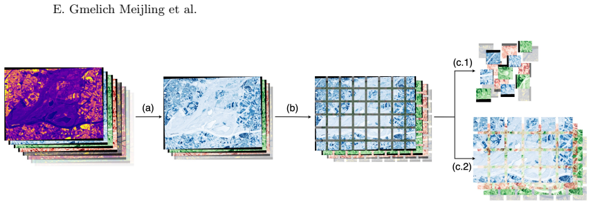
- [Section 3, Data Pre-processing] The high-resolution experiment randomly splits Biesbosch tiles into 1,027 training, 205 validation, and 136 test images, but the paper never states that the autoencoder used for pretraining was trained only on the training split. Since the autoencoder is described as trained on unlabeled RS data from the same area, the pretraining set may have included the exact tiles used for evaluation. If so, the 60.35% to 88.23% improvement in Table 3 is confounded by data leakage rather than attributable to self-supervised pretraining. This is load-bearing for the central claim, and the manuscript must explicitly describe the autoencoder's training split and confirm that no test tiles were seen during pretraining.
- [Section 3, High-resolution land cover labels] The manual labels created in Roboflow are used as ground truth for the high-resolution experiment, yet no inter-annotator agreement, independent validation, or quality assessment is reported. Without such validation, the accuracy numbers in Table 3 are not interpretable, especially because the manual labelling of vegetation classes at 0.3 m resolution is subjective. The paper's own Section 5 states that 'the absence of high-quality, detailed labels makes it difficult to distinguish meaningful quantitative results from potential hallucinations.' This admission directly weakens the credibility of the headline 88.23% figure, and the manuscript needs to provide evidence that the manual labels are reliable.
- [Section 4, Impact of pretraining on U-Net, Tables 2 and 3] All reported results come from a single run per configuration, with no standard deviations, confidence intervals, or statistical tests. Given the magnitude of the claimed pretraining effect on high-resolution data (28 percentage points), training stochasticity alone could produce substantial variation, particularly with small test sets and class-imbalanced labels. Reporting multiple seeds with mean and standard deviation, or at least a repeated evaluation, is necessary to support the quantitative comparison. Additionally, the Dice and IoU scores in Table 3 (0.4457 and 0.3919 for the pretrained model) are markedly lower than the accuracy, indicating strong class imbalance; class-wise precision and recall should be reported to clarify where the gains occur.
- [Section 4, Impact of Resolution, Table 4] The resolution comparison is not controlled: the medium-resolution results use Dynamic World labels, while the high-resolution results use the unvalidated manual labels, and the test regions differ (the Sentinel-2 test set is the Biesbosch region with a geographical split, whereas the Pleiades NEO test set is a random tile split within Biesbosch). Consequently, the claim that quantitative performance is 'comparable' between resolutions is not a meaningful comparison of resolution effects, since label quality and data partitioning differ. This experiment should either be redesigned to use the same label source and split protocol, or its conclusions should be limited to a qualitative visual assessment.
minor comments (6)
- [Introduction vs. Related work] The number of studies in the Jafarzadeh et al. review is given as 334 in the Introduction and as 344 in Related Work; please correct the inconsistency.
- [Section 2, Figures 2 and 3] The autoencoder bridge is described as having 512 channels (Figure 2), while the U-Net bridge is described as having 1024 channels (Figure 3). Please clarify whether the encoder architectures are identical, as claimed, or explain the difference.
- [Table 1] The 'Accuracy' column for autoencoder reconstruction is not defined. Since this is a reconstruction task, accuracy is an unusual metric; please specify how it is computed and whether it is pixel-wise or patch-wise.
- [Section 2, Autoencoder training] The hyperparameter selection for the autoencoder (learning rate, dropout) is attributed to the author's Master's thesis [7]; please provide more detail in the paper or a link to the thesis, as the details are not reproducible from the current text.
- [General] There are typographical and formatting issues, including 'It’s skip connections' (should be 'Its'), inconsistent spelling of 'Pleiades NEO' (e.g., 'Pl´ eiades Neo' vs. 'Pl´ eiades NEO'), and the use of 'Pl´ eiades Neo' in figure captions. Please proofread carefully.
- [Section 4, Autoencoder Reconstruction] The claim that the autoencoder 'reconstructs input images effectively' is difficult to reconcile with the low PSNR and SSIM values in Table 1 (e.g., PSNR 14.54, SSIM 0.4627 for Pleiades NEO). Please discuss what these numbers imply about reconstruction quality, or justify why they are considered acceptable.
Circularity Check
No circular derivation: the pretraining comparison is an empirical measurement, and no reported accuracy is equivalent to any fitted parameter or self-cited premise by construction.
full rationale
The paper reports an empirical comparison of U-Net training protocols (from-scratch vs autoencoder-initialized) on Sentinel-2 and Pléiades Neo data. No equation, fitted parameter, or theoretical claim is used to derive the headline accuracies (85.26%/85.42% and 60.35%/88.23%); these are measured test-set outcomes, so the central claim does not reduce to its inputs by definition. The only self-citation is to the first author's Master's thesis [7] for hyperparameter choices (learning rate 0.001, dropout 15%, cosine annealing); it is peripheral rather than load-bearing because both training regimes use identical settings and the pretraining benefit is measured empirically, not imported from [7]. The paper itself flags a serious validity limitation in Section 5: 'the absence of high-quality, detailed labels makes it difficult to distinguish meaningful quantitative results from potential hallucinations.' Likewise, the Pléiades Neo data preprocessing randomly splits Biesbosch tiles into train/validation/test but never states that the autoencoder was pretrained only on the training split; if the autoencoder saw the test-area tiles, the high-resolution pretraining gain would be confounded by data leakage. These are correctness and experimental-design concerns, not circularity: no result is definitionally equivalent to its inputs, and no load-bearing argument relies on a self-citation chain. Accordingly, the circularity score is 0.
Assumptions & free parameters
free parameters (6)
- Autoencoder learning rate =
0.001
- Dropout probability =
0.15
- Cloud cover threshold for Pleiades NEO =
30%
- Black pixel exclusion thresholds =
>10% for Sentinel-2, >30% for Pleiades NEO
- Patch sizes and batch sizes =
256x256/batch 8 for medium, 1024x1024/batch 4 for high
- Training epochs =
200 (medium AE), 9 (high AE), 300 (U-Net)
assumptions (5)
- domain assumption Dynamic World labels are accurate enough to train a medium-resolution segmentation model.
- domain assumption Manually annotated Pleiades NEO labels are reliable.
- domain assumption Models trained on other Dutch wetlands generalize to the Biesbosch test area.
- domain assumption The selected spectral bands are sufficient for wetland classification.
- standard math Backpropagation, convolutional architectures, and stochastic optimization behave as expected.
Cite this review
Pith. "Pith review of Supervised and self-supervised land-cover segmentation & classification of the Biesbosch wetlands." pith.science (2026). https://pith.science/paper/P4BY4Y6Q
@misc{pith2026250521269,
  author       = {Pith},
  title        = {Pith review of: Supervised and self-supervised land-cover segmentation & classification of the Biesbosch wetlands},
  year         = {2026},
  howpublished = {\url{https://pith.science/paper/P4BY4Y6Q}},
  note         = {Machine review of arXiv:2505.21269}
}
read the original abstract
Accurate wetland land-cover classification is essential for environmental monitoring, biodiversity assessment, and sustainable ecosystem management. However, the scarcity of annotated data, especially for high-resolution satellite imagery, poses a significant challenge for supervised learning approaches. To tackle this issue, this study presents a methodology for wetland land-cover segmentation and classification that adopts both supervised and self-supervised learning (SSL). We train a U-Net model from scratch on Sentinel-2 imagery across six wetland regions in the Netherlands, achieving a baseline model accuracy of 85.26%. Addressing the limited availability of labeled data, the results show that SSL pretraining with an autoencoder can improve accuracy, especially for the high-resolution imagery where it is more difficult to obtain labeled data, reaching an accuracy of 88.23%. Furthermore, we introduce a framework to scale manually annotated high-resolution labels to medium-resolution inputs. While the quantitative performance between resolutions is comparable, high-resolution imagery provides significantly sharper segmentation boundaries and finer spatial detail. As part of this work, we also contribute a curated Sentinel-2 dataset with Dynamic World labels, tailored for wetland classification tasks and made publicly available.
Figures


Figures from the paper (7 more)



Reference graph
Works this paper leans on
-
[1]
IEEE Transactions on Pattern Analysis and Machine Intelligence 47(4), 2245–2264 (2025)
Awais, M., Naseer, M., Khan, S., Anwer, R.M., Cholakkal, H., Shah, M., Yang, M.H., Khan, F.S.: Foundation models defining a new era in vision: A survey and outlook. IEEE Transactions on Pattern Analysis and Machine Intelligence 47(4), 2245–2264 (2025). https://doi.org/10.1109/TPAMI.2024. 3506283
-
[2]
Brown, C.F., Brumby, S.P., Guzder-Williams, B., Birch, T., Hyde, S.B., Mazzariello, J., Czerwinski, W., Pasquarella, V.J., Haertel, R., Ilyushchenko, S., Schwehr, K., Weisse, M., Stolle, F., Hanson, C., Guinan, O., Moore, R., Tait, A.M.: Dynamic World, Near real-time global 10 m land use land cover mapping. Scientific Data 9(1) (2022). https://doi.org/10....
-
[3]
In: IOP Conference Series: Earth and Environmental Science
Butko, I.M., Golubenko, O.I., Makoveichuk, O.M., Zaitsev, I.O., Kromkach, V.O.: Vegetation zone segmentation in multispectral imagery. In: IOP Conference Series: Earth and Environmental Science. vol. 1415. Institute of Physics (2024). https://doi.org/10.1088/1755-1315/1415/1/012068
-
[4]
Dahiya, R., Ojha, M.K., Saini, S., Ratna, S.: Satellite Image Segmentation Using U-Net. In: 2024 15th International Conference on Computing Communication and Networking Technologies, ICCCNT 2024. Institute of Electrical and Electronics Engineers Inc. (2024). https://doi.org/10.1109/ICCCNT61001. 2024.10726242
-
[5]
Advances in Neural Information Processing Systems 36 (2024)
Fuller, A., Millard, K., Green, J.: Croma: Remote sensing representations with contrastive radar-optical masked autoencoders. Advances in Neural Information Processing Systems 36 (2024)
work page 2024
-
[6]
Remote Sensing 7(8), 10938–10950 (2015)
Gallant, A.L.: The challenges of remote monitoring of wetlands. Remote Sensing 7(8), 10938–10950 (2015). https://doi.org/10.3390/rs70810938
-
[7]
Master’s thesis, Universiteit van Amsterdam (Feb 2025)
Gmelich Meijling, E.: AI-Driven Segmentation and Classification of Vegetation in the Biesbosch Flood- plain Using Remote Sensing Data. Master’s thesis, Universiteit van Amsterdam (Feb 2025)
work page 2025
-
[8]
In: Proceedings of the IEEE conference on computer vision and pattern recognition
He, K., Zhang, X., Ren, S., Sun, J.: Deep residual learning for image recognition. In: Proceedings of the IEEE conference on computer vision and pattern recognition. pp. 770–778 (2016). https://doi.org/ 10.1109/CVPR.2016.90
Show all 18 references
-
[9]
Remote Sensing 14(23) (2022)
Jafarzadeh, H., Mahdianpari, M., Gill, E.W., Brisco, B., Mohammadimanesh, F.: Remote Sensing and Machine Learning Tools to Support Wetland Monitoring: A Meta-Analysis of Three Decades of Research. Remote Sensing 14(23) (2022). https://doi.org/10.3390/rs14236104
2022 doi
-
[10]
Remote Sensing 15(16) (2023)
Janga, B., Asamani, G.P., Sun, Z., Cristea, N.: A Review of Practical AI for Remote Sensing in Earth Sciences. Remote Sensing 15(16) (2023). https://doi.org/10.3390/rs15164112
2023 doi
-
[11]
Remote Sensing 16(5) (2024)
Li, W., Hsu, C.Y., Wang, S., Yang, Y., Lee, H., Liljedahl, A., Witharana, C., Yang, Y., Rogers, B.M., Arundel, S.T., Jones, M.B., McHenry, K., Solis, P.: Segment anything model can not segment anything: Assessing ai foundation model’s generalizability in permafrost mapping. Re...
2024 doi
-
[12]
IEEE Geoscience and Remote Sensing Magazine (2025)
Lu, S., Guo, J., Zimmer-Dauphinee, J.R., Nieusma, J.M., Wang, X., Wernke, S.A., Huo, Y., et al.: Vision foundation models in remote sensing: A survey. IEEE Geoscience and Remote Sensing Magazine (2025). https://doi.org/10.1109/MGRS.2025.3541952
2025
-
[13]
GIScience and Remote Sensing 55(5), 623–658 (2018)
Mahdavi, S., Salehi, B., Granger, J., Amani, M., Brisco, B., Huang, W.: Remote sensing for wetland classification: a comprehensive review. GIScience and Remote Sensing 55(5), 623–658 (2018). https: //doi.org/10.1080/15481603.2017.1419602
2018
-
[14]
Science of the Total Environment 861 (2023)
Mainali, K., Evans, M., Saavedra, D., Mills, E., Madsen, B., Minnemeyer, S.: Convolutional neural network for high-resolution wetland mapping with open data: Variable selection and the challenges of a generalizable model. Science of the Total Environment 861 (2023). https://do...
2023
-
[15]
In: Medical image computing and computer-assisted intervention–MICCAI 2015: 18th interna- tional conference, Munich, Germany, October 5-9, 2015, proceedings, part III 18
Ronneberger, O., Fischer, P., Brox, T.: U-net: Convolutional networks for biomedical image segmen- tation. In: Medical image computing and computer-assisted intervention–MICCAI 2015: 18th interna- tional conference, Munich, Germany, October 5-9, 2015, proceedings, part III 18....
2015 doi
-
[16]
Journal of Environmental Management 286, 112160 (2021)
Salimi, S., Almuktar, S.A., Scholz, M.: Impact of climate change on wetland ecosystems: A critical review of experimental wetlands. Journal of Environmental Management 286, 112160 (2021)
2021
-
[17]
In: Chaud- huri, K., Salakhutdinov, R
Tan, M., Le, Q.: EfficientNet: Rethinking model scaling for convolutional neural networks. In: Chaud- huri, K., Salakhutdinov, R. (eds.) Proceedings of the 36th International Conference on Machine Learn- ing. Proceedings of Machine Learning Research, vol. 97, pp. 6105–6114. PM...
2019
-
[18]
Nature Sustainability 3(10), 853–862 (2020)
Zhu, Z., Vuik, V., Visser, P.J., Soens, T., van Wesenbeeck, B., van de Koppel, J., Jonkman, S.N., Tem- merman, S., Bouma, T.J.: Historic storms and the hidden value of coastal wetlands for nature-based flood defence. Nature Sustainability 3(10), 853–862 (2020). https://doi.org...
2020 doi
Reviewed August 7, 2026 · model on record in the stance chip above.
Discussion (0). Sign in to comment.