REVIEW 3 major objections 3 minor 14 references
Towards Genuine Coexistence: Per-Satellite Emission and Radiation Limits to Protect Radio Astronomy and Geodetic VLBI at 1-14 GHz from Satellite Constellations
T0 review · 3 major / 3 minor · reviewed 2026-08-16 · deepseek-v4-flash
Pith's one-line read Measured satellite emissions already breach radio astronomy protection thresholds across 1–14 GHz, and the second harmonic of one downlink already costs geodetic VLBI at least 59% of its data.
desk verdict Serious, measurement-grounded interference study that gives regulators usable per-satellite limits; the 59% VLBI data-loss figure is a lower bound that will shift with better harmonic characterization, but the overall result holds. read the letter →
The pith
A machine-rendered reading of the paper's core claim, the machinery that carries it, and where it could break.
The reading
What carries the argument
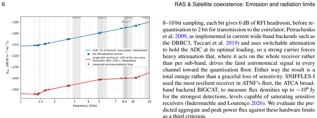
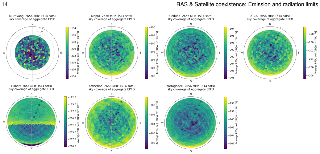
The carrying mechanism is a Monte-Carlo equivalent power flux density (EPFD) simulation that propagates the actual catalogued orbits of the present fleet, weights each satellite's measured emission or radiation by the receiving antenna gain toward it using a standard reference pattern, and compares the summed aggregate against the protection thresholds interpolated across 1–14 GHz. The per-satellite inputs come from a companion survey that measured flux-calibrated emission levels from about 4,600 tracked observations, separated into intended emissions, spurious emissions (harmonics and frequency-conversion products), and unintended electromagnetic radiation. An analytic scaling, verified by direct simulation of cloned fleets, extends the aggregate linearly with constellation size, and the analysis is inverted to express the protection requirement as a per-satellite field-strength limit in dB(µV/m) at 10 m in a 1 MHz bandwidth. A bandwidth correction is central: broadband harmonics fill the 32 MHz VGOS channel, while narrowband radiation is diluted and largely spares VLBI, so the bright downlink harmonics, not the platform noise, set the VLBI threat.
What would settle it
Track a large sample of Direct-to-device satellites with a receiver that does not compress, such as a 16-bit digitizer or an attenuated calibration path, to recover the true level and bandwidth of the 5240 MHz second harmonic over many passes; if the uncompressed level is more than about 12 dB below the apparent measured value, the paper's headline 59% VLBI data loss is an overestimate, and a direct measurement of the fraction of 2000 s VGOS scans whose aggregate exceeds the VLBI threshold would settle the matter.
Extended reading notes
Core claim
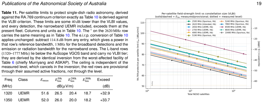
The paper's central claim is that the aggregate radio emission and radiation from low-Earth-orbit satellite constellations, measured directly at the telescopes rather than taken from filings, already exceeds the radio-astronomy protection criteria (RA.769) for single-dish observations across 1–14 GHz, and that the dominant threat to geodetic VLBI is the spurious second harmonic of the 2620 MHz Direct-to-device downlink at 5240 MHz. Using a Monte-Carlo equivalent power flux density model over the catalogued orbits of about 12,000 satellites and scaling to 100,000 and 300,000 satellites, the authors find 59% data loss for VGOS VLBI today at 5240 MHz, a lower bound because the measurement compresses the calibrating receiver, rising to 100% at 300,000; the 7860 MHz third harmonic rises from 7.3% to 68%. Inverting the same analysis gives a per-satellite emission ceiling of about 65–70 dB(µV/m) at 10 m in 1 MHz for geodetic VLBI at 300,000 satellites, and 18–46 dB(µV/m) for single-dish radio astronomy, with current spacecraft exceeding the single-dish ceilings by 20–74 dB at every calibrated detection. The authors argue this is a spacecraft-engineering problem with a known solution, radiated-emission masks of the type spacecraft already meet for launch-vehicle compatibility, and propose a per-satellite mask that tightens as constellations grow.
Load-bearing premise
The projections assume the future fleet looks like today's in composition, with satellites carrying the Direct-to-device downlink remaining about 5.4% of the total and each measured emission appearing in the same fraction of the fleet as observed; if the DTD share grows, the quoted limits tighten and 100% VLBI data loss arrives before 300,000 satellites.
Editorial extensions
If this is right
- Adopting the proposed per-satellite ceilings would require satellite operators to suppress spurious emissions and unintended radiation by tens of decibels, a level the paper argues is within existing aerospace electromagnetic-compatibility practice.
- If the fleet reaches 300,000 satellites with today's share of Direct-to-device payloads, VGOS geodetic VLBI loses 100% of its data at the 5240 MHz harmonic and 68% at 7860 MHz, degrading the reference frames and UT1–UTC products that underpin GNSS and timing services.
- High-sensitivity single-dish radio astronomy in several 1–14 GHz bands is already foreclosed today rather than merely degraded, because the measured emissions push the whole-sky aggregate above the protection criterion at the present fleet.
- A per-satellite limit that falls 10 dB per decade of fleet growth gives regulators a concrete, non-gameable target that shifts the compliance burden onto the largest constellations while letting small operators fly within a uniform mask.
Reading between the lines
- If the Direct-to-device share of future fleets grows beyond today's 5.4%, every numerical limit in the paper tightens further; the 300,000-satellite column would then understate the threat, and the VLBI-friendliest DTD band near 852–960 MHz conflicts directly with the 21 cm hydrogen-line observations that occupy the same low spectrum.
- The paper's bandwidth criterion suggests a cheap pre-launch certification test: measure not only the carrier power of each downlink but the bandwidth of every harmonic and clock product, since narrowband radiation is harmless to VLBI while broadband harmonics are not.
- The same inversion method, turning an aggregate protection threshold into a per-unit emission ceiling, could be applied to other passive users of the spectrum or to analogous aggregate problems such as reflected sunlight from very large constellations affecting optical astronomy.
Signed reviews
Editorial analysis
A structured set of objections, weighed in public.
Referee Report
Summary. This paper combines the SNIFFLES-I survey measurements of intended emissions, spurious emissions, and unintended electromagnetic radiation (UEMR) from NGSO constellations with a Monte-Carlo equivalent power flux density (EPFD) model to quantify interference to Australian radio astronomy facilities and to the AuScope geodetic VLBI (VGOS) array across 1–14 GHz. It then scales the present catalogued fleet to 100,000 and 300,000 satellites and inverts the ITU-R RA.769 protection criteria to derive per-satellite emission and radiation ceilings in dB(µV/m) at 10 m in a 1 MHz reference bandwidth. The central claims are that the single-dish continuum criterion is already exceeded at all measured bright detections, that the 5240 MHz second harmonic of the 2620 MHz Direct-to-device (DTD) downlink causes at least 59% VLBI data loss today and 100% at 300,000 satellites, that the corresponding per-satellite VLBI ceiling is 65–70 dB(µV/m) while current spacecraft exceed it by 20–74 dB, and that narrowband UEMR is diluted against the 32 MHz VGOS channel and does not breach the VLBI criterion. A separate, more speculative analysis treats proposed orbital data centres as a UEMR-dominated megaconstellation.
Significance. If the results hold, this paper provides the first directly measurement-anchored, quantitative bridge between operational NGSO constellation emissions and the per-satellite limits that standard-setting bodies could apply, which is timely and policy-relevant for the proposed WRC-31 agenda item on geodetic VLBI. The manuscript has clear strengths: the EPFD engine is validated against a dedicated 2098 s observing run (§4.5); the linear-in-N scaling is checked against direct Monte-Carlo simulations of genuinely up-scaled fleets (§6.1); and the per-satellite inversion in Eq. (7) is genuinely parameter-free with respect to the measured level, since the measured EIRP cancels. The full data grid and plot set are available, supporting reproducibility. The main risks are concentrated in the small-sample near-isotropy assumption for the DTD harmonics and in the frozen future-fleet composition, both of which the authors partially acknowledge but which affect the headline numerical limits.
major comments (3)
- [§4.3, Table 5, §7.1] The 5240 MHz DTD second harmonic is the principal VLBI threat, but its per-satellite input is a single compressed peak-selected lower bound (ATCA ≥ −76.1 dB(W/Hz); E_meas = 98.7 dB(µV/m)) that drove the calibrating back-end into compression in 21 of 36 passes. The paper uses this value as a constant, near-isotropic, unity-duty-cycle radiator for every DTD satellite, and the near-isotropy claim rests on only 19, 8, and 5 tracked passes for the second, third, and fourth harmonics, with no per-pass flux distribution or off-axis dependence shown. Because the aggregate, the 59% VLBI loss, N_breach ≈ 188, and the +32.0 dB exceedance in Table 10 all scale linearly with this single input, I ask for per-pass flux statistics, an explicit compression correction or bound, and a demonstration that the conclusions are unchanged if the harmonic is patchy in elevation or azimuth. The direction of the error from compression is conservative (true loss is higher), but the numerical limits and breach populations are not protected by that direction.
- [§4.2, Tables 10 and 11] The 300,000-satellite scenario fixes the DTD-capable share at 5.4% of the fleet and the measured active fraction at 0.869. The authors correctly state in §4.2 that this is the one direction in which the assumptions are anti-conservative, and they quote dB shifts for larger DTD shares in the text, but the headline per-satellite ceilings (65–70 dB(µV/m) for VLBI; 18–46 dB(µV/m) for single-dish) are tabulated without this dependence. Since these ceilings are the paper's central deliverable for standard-setting bodies, the tables should state the assumed DTD share and include at least a one-line sensitivity (for example, 50% and 100% DTD share) so that a regulator does not apply a ceiling that is too loose under a plausible future composition. I do not regard this as an internal inconsistency; it is an applicability gap in the presentation of the main numerical product.
- [§6.1, Figure 10, Table 8] The authors show that the rigid 10 log10(N/N0) shift underestimates the true VLBI data loss for the not-yet-saturated detections: the 7860 MHz third harmonic reaches a true 92% loss at 300,000 satellites against 71% from the linear estimate, and the corrected compound-resampling method reproduces direct simulations to within a few points. Table 8 and the main text nevertheless quote the linear-estimate value of 68% at 300,000. Given that the corrected method is already validated and described in the same section, the tabulated and narrative loss figures should either be the corrected values or be explicitly labelled as analytic lower bounds. This matters because 68% is one of the headline quantitative claims for the 300,000-satellite scenario and the paper already possesses the machinery to state the more accurate number.
minor comments (3)
- [§4.3] There is a typo in the sentence describing the beam alignment: 'closely aligned towawrds telescope boresight' should read 'closely aligned towards telescope boresight'.
- [Figure 14 caption] The caption text 'all expressed at 10 min a 1 MHz reference bandwidth' should read 'all expressed at 10 m in a 1 MHz reference bandwidth'; the current phrasing is confusing.
- [Table 5] The table uses red text to mark placeholder and floor-only entries, but this information will be lost in monochrome print; please add a symbol or footnote marker in addition to colour.
Circularity Check
No circular derivation: Eq. (7) cancels the measured level, and the central predictions rest on external measurements and independent validation; only a minor in-preparation self-citation appears.
full rationale
The paper's derivation chain is self-contained in the sense required for circularity analysis. Per-satellite emission inputs are taken from the SNIFFLES-I survey (Indermuehle and Lourenco 2026), which is an observational dataset rather than a result derived from the paper's conclusions; the same-group authorship is a self-citation but not a circular premise. The active fractions and per-line detection rates are measured inputs, not fitted to the data-loss targets. The aggregate EPFD is computed by Monte-Carlo propagation using the RA.1631 receiving pattern and compared against RA.769 thresholds; data loss is the fraction of realisations exceeding the threshold, so it is not an identity with any input. The per-satellite limits are derived by an explicit inversion, Eq. (7): EIRPlim = Slim - K - 10log10(N/N0), and the paper correctly notes that EIRPmeas cancels in the margin inversion. The limits therefore depend on the RA.769 threshold and aggregate geometry, not on the measured level, so the 'prediction' of per-satellite ceilings is not the measured input renamed. The linear extrapolation is validated against direct Monte-Carlo runs of cloned fleets, and the EPFD machinery is validated against a dedicated ATCA stare observation. The only notable self-citation of unpublished work is the in-preparation boresight-avoidance trial, which supports a suggested mitigation and is explicitly hedged ('likely rather than certain'); it is not load-bearing for the main data-loss or limit results. Stated limitations, such as compressed lower bounds on bright detections, frozen fleet composition, and unmeasured ODC UEMR, are data-quality or scenario uncertainties rather than circular steps. Overall, no prediction reduces by construction to its own input; the score of 2 reflects only the minor in-preparation self-citation and the strong reliance on the authors' own survey as observational input.
Assumptions & free parameters
free parameters (5)
- Per-detection radiating active fraction =
0.12 to 1.00 (e.g. DTD 0.87, GuoWang 0.25, OneWeb 1.00)
- Effective emission bandwidth for narrowband UEMR =
5 kHz default; 10 kHz for OneWeb 8599 MHz
- Future DTD share of fleet =
5.4% carried forward from today's 642 of 11,981 satellites
- ODC per-platform UEMR baseline =
v2-Mini floor around -119 dB(W/Hz) EIRP spectral density
- ODC shell packing separation =
50 km minimum neighbour separation
assumptions (7)
- domain assumption RA.769-2 protection thresholds are the correct yardstick, including interpolation to unallocated frequencies.
- domain assumption Emission and radiation from satellites is modelled as 0 dBi isotropic on the transmit side.
- domain assumption RA.1631 reference single-dish antenna pattern with aperture efficiency unity represents the receiving stations.
- domain assumption All detected emissions operate continuously with duty cycle unity.
- ad hoc to paper The orbital-data-centre fleet radiates UEMR similar to Starlink v2-Mini and has no significant radio payload.
- ad hoc to paper Future constellation composition preserves today's radiating fractions and orbital geometry.
- domain assumption SNIFFLES-I detection floor values bound uncalibrated L-band detections from below.
Cite this review
Pith. "Pith review of Towards Genuine Coexistence: Per-Satellite Emission and Radiation Limits to Protect Radio Astronomy and Geodetic VLBI at 1-14 GHz from Satellite Constellations." pith.science (2026). https://pith.science/paper/PFTGNNHW
@misc{pith2026260811659,
  author       = {Pith},
  title        = {Pith review of: Towards Genuine Coexistence: Per-Satellite Emission and Radiation Limits to Protect Radio Astronomy and Geodetic VLBI at 1-14 GHz from Satellite Constellations},
  year         = {2026},
  howpublished = {\url{https://pith.science/paper/PFTGNNHW}},
  note         = {Machine review of arXiv:2608.11659}
}
read the original abstract
Geodetic very long baseline interferometry (VLBI) is a vulnerable application of the radio astronomy service (RAS): it provides the fundamental link between the celestial and terrestrial reference frames, and is the only technique that uniquely determines UT1-UTC. The next-generation geodetic VLBI Global Observing System (VGOS) achieves millimetre accuracy by synthesising group delay across 3-14 GHz using 32x32 MHz channels, most of which lie outside RAS primary allocations. The SNIFFLES-I survey (Indermuehle et al 2026) measured intended emissions, unwanted emissions (spurious emissions, notably harmonics), and unintended electromagnetic radiation (UEMR) of NGSO systems from 1-26 GHz. On this basis we model the equivalent power flux density (EPFD) of current and future constellations and compare against protection criteria of ITU-R RA.769. The analysis extends to frequencies without radio astronomy allocations where SNIFFLES-I made detections. For geodetic VLBI, we run a Monte-Carlo EPFD model at the AuScope VGOS stations and scale the aggregate from the present catalogued fleet (~12000 satellites) to the hundreds of thousands on file with a validated method. Inverting the EPFD analysis against the interpolated RA.769 thresholds yields maximum tolerable per-satellite levels for spurious emissions and for UEMR, expressed as a field-strength limit in dB(uV/m) at 10 m for standard-setting bodies. We treat proposed orbital-data-centres in Sun-synchronous orbit as a distinctively UEMR-dominated case. We find that already today the single-dish protection criteria are exceeded in two primary RAS bands. For geodetic VLBI, the dominant threat is spurious emission from the 2620 MHz Direct-to-device (DTD) downlink, whose second harmonic at 5240 MHz already causes at least 59% data loss today. (Abstract modified for arxiv limits)
Figures


Figures from the paper (13 more)





Reference graph
Works this paper leans on
-
[1]
AIAA S-121A-2017: Electromagnetic compatibility require- ments for space equipment and systems
AIAA 2017,. AIAA S-121A-2017: Electromagnetic compatibility require- ments for space equipment and systems. Technical report, American Institute of Aeronautics and Astronautics. Reaffirmed
work page 2017
-
[5]
https://cept.org/files/1412/ECC(25)059 Annex1 Mandate%20to%20the% 20CEPT%20on%20D2D-IMT%20in%20EU-harmonised%20ECS% 20bands.pdf. European Commission 2026,. Commission proposes new authorisation for mobile satellite services for the EU’s resilience and competitiveness. Technical report, European Commission. Press release IP/26/1170. https: //ec.europa.eu/c...
work page 2026
-
[10]
https://storage. googleapis.com/rideshare-static/Rideshare Payload Users Guide.pdf; pay- load radiated-emission limits and protected-band notches (e.g. GPS notch at 1575.42 MHz). Tuccari, G., Alef, W., Dornbusch, S., Wunderlich, M., Roy, A., Rottmann, H., Wagner, J., Haas, R., & Johansson, K. DBBC3 the new wide-band backend for VLBI. InProceedings of the ...
work page 2019
-
[11]
SpaceX Gen2 direct-to-cellular system, attachment a: Technical information to supplement schedule s
SpaceX 2023,. SpaceX Gen2 direct-to-cellular system, attachment a: Technical information to supplement schedule s. FCC ICFS File No. SAT-MOD-20230207-00021. Peak e.i.r.p.+58 dBW; peak e.i.r.p. density −2.33 dB(W/Hz) per 1.4 MHz channel. SpaceX 2024,. Rideshare payload user’s guide. Version
work page 2023
-
[14]
https: //www.iso.org/standard/77484.html. ITU-R 2003,. Recommendation ITU-R RA.769-2: Protection criteria used for radio astronomical measurements. Technical report, International Telecommunication Union, Radiocommunication Sector, Geneva. ITU-R 2010,. Report ITU-R RA.2188: Power flux-density and e.i.r.p. lev- els potentially damaging to radio astronomy r...
work page 2003
-
[47]
Astropy Collaboration 2022, The astropy project: Sustaining and growing a community-oriented open-source project and the latest major release (v5.0) of the core package.The Astrophysical Journal, 935,
work page 2022
-
[67]
Niell, A., Barrett, J., Burns, A., Cappallo, R., Corey, B., Derome, M., Eckert, C., Elosegui, P., McWhirter, R., Poirier, M., Rajagopalan, G., Rogers, A., Ruszczyk, C., SooHoo, J., Titus, M., & Whitney, A. 2018, Demonstration of a broadband very long baseline interferometer system: A new instrument for high-precision space geodesy.Radio Science, 53(10), 1...
work page 2018
-
[140]
J., Stevenson, T., Cantor, R., Hilliard, L., Murphy, T
Turner, C. J., Stevenson, T., Cantor, R., Hilliard, L., Murphy, T. E., & Bulcha, B. 2023, Superconducting notch filter for rfi mitigation in ground-based radio telescope.IEEE Transactions on Applied Superconductivity, 33(3), 1–5. UN-GGCE 2024,. Hidden Risk. Technical report, United Nations Global Geodetic Centre of Excellence. UN-GGCE 2026,. State of geod...
work page 2023
Show all 14 references
-
[167]
Draft new resolution and agenda item for WRC-31: shar- ing and compatibility studies for geodetic VLBI (VGOS)
Australia/APT 2026,. Draft new resolution and agenda item for WRC-31: shar- ing and compatibility studies for geodetic VLBI (VGOS). Draft WRC-27 input contribution toward a WRC-31 agenda item. Australian Communications and Media Authority 2025,. Australian radiofrequency spect...
2026 arXiv
-
[272]
Winkel, B. 2021,. cysgp4: a wrapper around the SGP4 satellite propagation library. Astrophysics Source Code Library, ascl:2102.014. Winkel, B. & Jessner, A. 2018, Spectrum management and compatibility studies with Python.Advances in Radio Science, 16, 113–121. pycraf; arXiv:18...
2021 arXiv
-
[1170]
ECSS- E-ST-20-07C rev
European Cooperation for Space Standardization 2022,. ECSS- E-ST-20-07C rev. 2: Space engineering — electromagnetic compatibility. ECSS Standard. https://ecss.nl/standard/ ecss-e-st-20-07c-rev-2-electromagnetic-compatibility-3-january-2022/. Falle, A., Wright, E., Boley, A., &...
2022 arXiv
-
[2023]
Akgiray, A., Weinreb, S., Imbriale, W
https://doi.org/ 10.2514/4.105203.001. Akgiray, A., Weinreb, S., Imbriale, W. A., & Beaudoin, C. 2013, Circular quadruple-ridged flared horn achieving near-constant beamwidth over mul- tioctave bandwidth: Design and measurements.IEEE Transactions on Antennas and Propagation, 6...
2013 doi
-
[2024]
Articles, Appendices, Resolutions and Recommendations incorporating the decisions of WRC-23; international treaty
Technical report, International Telecommunication Union, Geneva. Articles, Appendices, Resolutions and Recommendations incorporating the decisions of WRC-23; international treaty. ITU-R 2024,c. Recommendation ITU-R SM.329-13: Unwanted emissions in the spurious domain. Technica...
2024
-
[2026]
People’s Republic of China 2013,
https://www.ofcom.org.uk/spectrum/space-and-satellites/ direct-to-device-licence-exemption-regulations-update. People’s Republic of China 2013,. GJB 151B-2013: Electromagnetic emission and susceptibility requirements and measurements for military equipment and subsystems. Chin...
2013
Reviewed August 16, 2026 · model on record in the stance chip above.
Discussion (0). Continue with ORCID to comment.