REVIEW 4 major objections 6 minor 12 references
Implicit 3D scene reconstruction using deep learning towards efficient collision understanding in autonomous driving
T0 review · 4 major / 6 minor · reviewed 2026-08-06 · deepseek-v4-flash
Pith's one-line read Sparse LiDAR scans can be turned into continuous signed-distance obstacle maps by a small neural net.
desk verdict Useful pilot ablation, but the load-bearing SDF labels are fabricated from LiDAR ray geometry and no collision experiment exists, so the main claim is unsupported. read the letter →
The pith
A machine-rendered reading of the paper's core claim, the machinery that carries it, and where it could break.
The reading
What carries the argument
The central object is the Signed Distance Function $S(p)$, the distance from a query point $p\in\mathbb{R}^3$ to the nearest obstacle surface, with negative sign inside the watertight boundary. A small fully connected network with a Fourier feature encoder maps spatial inputs to a predicted $(S(p), C(p))$ pair, where the zero level set $\{p:S(p)=0\}$ is taken as the obstacle shape and $C(p)$ is a confidence value computed by a formula borrowed from prior work that downweights large negative distances. The K-D tree accelerates the nearest-neighbour distance labelling needed to build training targets.
What would settle it
Reconstruct a NuScenes scene with this pipeline and compare the predicted zero-level surface $\{p:S(p)=0\}$ against a ground-truth watertight mesh or dense multi-sweep occupancy map of the same scene; if the synthetic negative points are not actually inside occupied space, the surface will be systematically offset and interior/exterior queries will disagree with true occupancy.
Extended reading notes
Core claim
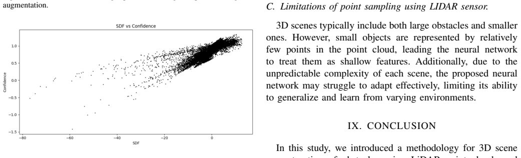
The central claim is that implicit 3D reconstruction through a learned SDF gives a continuous, storage-efficient map of obstacle surfaces, and that the zero set of the network defines the obstacle boundary more accurately than traditional polygonal representations. On NuScenes static scenes, a three-layer fully connected network with $\tanh$ activation, Huber loss, Adam, and Fourier feature encoding fits SDF labels, and the reported experiments show the Fourier encoder roughly halves the loss (from 0.4 to 0.18) and keeps invalid confidence predictions for interior points within $0$ to $-0.5$, compared with $0$ to $-3$ under uniform sampling. The paper presents this as the first learning-based SDF reconstruction aimed specifically at collision understanding in autonomous driving, and argues that boundary-level detail is precisely what dense, dynamic traffic requires.
Load-bearing premise
The load-bearing premise is that points generated beyond each LiDAR termination point really lie inside an obstacle, so their negative distances are valid ground truth; if they fall in free space, the learned field is artificial and every downstream collision-use claim collapses.
Editorial extensions
If this is right
- An accurate learned SDF lets a vehicle query the distance from any point to any obstacle surface directly, so proximity checks no longer depend on stored meshes or bounding-box approximations.
- The confidence output can flag unreliable interior distances, giving downstream planners a principled way to distrust predictions in occluded or far-away regions.
- Fourier feature encoding is the main accuracy lever in the reported tests, so future LiDAR-based SDF pipelines should include it.
- Shallower networks outperform deeper ones beyond roughly 18 layers, which keeps online reconstruction costs low.
- Gaussian negative sampling near the LiDAR termination point is preferable to uniform sampling because it reduces invalid confidence scores for negative distances.
Reading between the lines
- Editorial: the synthetic negative points beyond the LiDAR termination point assume that every obstacle is solid behind its visible surface; a direct test is to compare the learned field against dense multi-sweep occupancy or watertight CAD models of the same scenes.
- Editorial: the same SDF field could feed motion planning directly through its gradient as a repulsive potential, turning reconstruction fidelity into a quantitative safety margin.
- Editorial: extending the static field to dynamic obstacles would require conditioning the network on time or object identity, and the confidence output could then double as an occupancy-uncertainty measure for occluded regions.
Signed reviews
Editorial analysis
A structured set of objections, weighed in public.
Referee Report
Summary. The paper proposes a learning-based method for implicit 3D scene reconstruction of static obstacles from LiDAR point clouds, using a fully connected network with Fourier feature encoding to predict a signed distance function (SDF) and a per-point confidence. The authors evaluate three design choices: uniform versus Gaussian augmentation along LiDAR rays, model depth with and without skip connections, and the addition of a Fourier feature encoder. The only reported quantitative results are Huber losses on the authors' own training setup, and the paper also reports invalid confidence predictions for negative SDF values. The central claim is that the resulting boundary-level SDF representation would enhance collision detection in congested driving scenarios, but no collision-detection experiment or reconstruction metric against ground truth is provided.
Significance. If the claimed result held, a compact implicit SDF representation with boundary-level accuracy could be a useful alternative to bounding-box representations for proximity estimation in dense traffic. The work addresses a relevant problem and includes useful ablations of augmentation strategies, Fourier features, and model capacity. However, the paper's evidence is far from sufficient: the only numerical results are training losses on self-generated labels, there is no held-out evaluation, no reconstruction metric, no comparison with baselines, and no collision experiment. The paper also explicitly reports confidence values outside the allowed probability range. The direction is interesting, but the current manuscript does not support its central claims.
major comments (4)
- [Section VI-A] The negative SDF labels are fabricated by generating points beyond the LiDAR termination point and truncating them. A termination point is the first surface hit along a ray, so the region beyond it is not necessarily occupied; for thin or non-watertight objects, or through gaps, it can be free space. Since these negative samples are the only source of inside-object supervision, the learned zero-level set may not correspond to actual obstacle boundaries. The paper never validates the sign or magnitude of these labels against true occupancy (e.g., meshes, multi-sweep consistency, or manual labels), and the collision-detection claim depends directly on this assumption.
- [Section VII-A and Eq. (1)] The paper reports that for negative SDF values the model produces invalid confidence scores, including values from 0 to -3 for the uniform augmentation and 0 to -0.5 for the Gaussian augmentation. Equation (1) is described as producing a probability, but the reported outputs are not probabilities, and the range of the hyperparameter b is never specified. Without a meaningful and calibrated confidence output, the proposed confidence mechanism cannot support any collision-reasoning application.
- [Table I and Section VI-B] The only quantitative results are Huber losses computed on the authors' own training setup. There is no held-out validation or test set, no error bars, no comparison against ground-truth SDF values (e.g., Chamfer distance, F-score, voxel IoU), and no comparison with a baseline representation such as bounding boxes. The reported loss reductions (from 0.37 to 0.18) measure fit to self-generated labels, not reconstruction accuracy or collision-relevant performance.
- [Abstract and Section IX] The central claim that the method 'would significantly enhance collision detection performance' is not tested anywhere in the manuscript. No collision-detection, proximity-estimation, or planning experiment is reported, and no metric such as distance-to-obstacle error in dense traffic is computed. The claim is supported only by training-loss comparisons and must either be substantiated with appropriate experiments or removed.
minor comments (6)
- [Section IV] The sentence describing the network configuration is ambiguous: 'with tanh, Huber loss, Adam, 0.4 as activation function, loss function, optimizer, and learning rate' does not clearly map each term to its role, and a learning rate of 0.4 would be unusually high and should be justified.
- [Section IV] The phrase 'output two values, the sine distance along with a confidence value' contains a typo; it should read 'signed distance'.
- [Section V] The Directed Hausdorff distance threshold used for scene selection is not reported or justified, and the ground-plane threshold of -1.563 meters is presented without context.
- [Section III] The bullet list under 'Requirements when calculating confidence score' is difficult to parse, and the text preceding Eq. (1) does not clearly define d(p) and d_max in relation to each LiDAR ray.
- [Section VIII] There are two subsections titled 'Limitations of point sampling using LIDAR sensor' (B and C), which is confusing; the second should be retitled.
- [Abstract and throughout] The manuscript contains numerous grammatical errors and typos, such as 'build a the static Signed Distance Function (SDF) maps', 'the sign distance function represents any shape through parameters', and 'Object maps ... It depicts actual sceneries'. A careful proofreading pass is needed.
Circularity Check
The reconstructed obstacle boundary is anchored by construction to the LiDAR termination points via self-generated negative labels, and the collision-detection claim is extrapolated from loss on these self-constructed labels.
-
self definitional
[Section IV (Decision boundary) and Section VI-A (Data augmentation techniques)]
"Positive points were taken from the LiDAR origin to the object surface, while negative points were generated beyond the termination point. ... The Decision boundary of the neural network, where sign distance s(p) = 0 considered the 3D shape of the obstacle."
The sign labels are constructed so that the positive-to-negative transition lies exactly at the LiDAR termination point, i.e., the visible surface. The network is then trained to place its zero-level set at that transition. Therefore the output '3D shape' is, by construction, the input termination surface; no independent occupancy, back-surface, or mesh signal is used. The reported Huber losses (0.37 to 0.18) only quantify fit to this self-generated label set, so the boundary-level accuracy claim reduces to the augmentation procedure.
-
fitted input called prediction
[Abstract and Section VII-A / Table I]
"Our preliminary results demonstrate that this method would significantly enhance collision detection performance, particularly in congested and dynamic environments."
The only experimental evidence provided is training loss on the self-constructed SDF labels (Table I). No collision-avoidance experiment, occupancy metric, or geometric benchmark against real obstacle geometry is reported. The collision-detection 'prediction' is therefore supported solely by how well the network fits the authors' own fabricated negative samples, making the claimed downstream benefit an extrapolation from the fitted input rather than a measured result.
full rationale
The paper contains no load-bearing self-citation, but its central reconstruction claim is circular in a definitional sense. Section VI-A builds the training set by sampling positive points from the LiDAR origin to the surface and negative points beyond the termination point, so the sign change in the SDF labels is imposed exactly at the visible surface. The network's zero-level set, which Section IV declares to be the obstacle shape, is therefore trained to reproduce the input termination points. The reported loss improvements only show that the network can fit these self-authored labels, not that the resulting field matches real occupancy. The paper itself acknowledges that the LiDAR 'could only capture the visible surface of the object' and that the negative distances are not true inside-object distances, yet no independent validation against meshes, occupancy grids, or collision metrics is provided. The confidence model borrowed from [11] has an unspecified hyperparameter b and produces invalid negative confidence values in the paper's own results, further undermining the reliability signal, though this is an internal inconsistency rather than a circular step. Overall, the boundary-level reconstruction and the collision-detection benefit reduce to the authors' augmentation construction, warranting a score of 6.
Assumptions & free parameters
free parameters (6)
- confidence hyperparameter b =
not reported
- Fourier feature scale/frequency parameters =
not reported
- Hausdorff distance threshold for scene selection =
not reported
- ground-plane threshold =
-1.563 meters
- KD-tree leaf count =
50
- learning rate =
0.4
assumptions (4)
- domain assumption LiDAR returns lie exactly on obstacle surfaces
- ad hoc to paper Synthetic negative samples placed beyond the LiDAR ray termination represent the interior of obstacles
- domain assumption The scene is static and the ego pose is known exactly
- domain assumption The confidence equation from [11] applies unchanged to nuScenes LiDAR data
Cite this review
Pith. "Pith review of Implicit 3D scene reconstruction using deep learning towards efficient collision understanding in autonomous driving." pith.science (2026). https://pith.science/paper/PYGGKSZX
@misc{pith2026250615806,
  author       = {Pith},
  title        = {Pith review of: Implicit 3D scene reconstruction using deep learning towards efficient collision understanding in autonomous driving},
  year         = {2026},
  howpublished = {\url{https://pith.science/paper/PYGGKSZX}},
  note         = {Machine review of arXiv:2506.15806}
}
read the original abstract
In crowded urban environments where traffic is dense, current technologies struggle to oversee tight navigation, but surface-level understanding allows autonomous vehicles to safely assess proximity to surrounding obstacles. 3D or 2D scene mapping of the surrounding objects is an essential task in addressing the above problem. Despite its importance in dense vehicle traffic conditions, 3D scene reconstruction of object shapes with higher boundary level accuracy is not yet entirely considered in current literature. The sign distance function represents any shape through parameters that calculate the distance from any point in space to the closest obstacle surface, making it more efficient in terms of storage. In recent studies, researchers have started to formulate problems with Implicit 3D reconstruction methods in the autonomous driving domain, highlighting the possibility of using sign distance function to map obstacles effectively. This research addresses this gap by developing a learning-based 3D scene reconstruction methodology that leverages LiDAR data and a deep neural network to build a the static Signed Distance Function (SDF) maps. Unlike traditional polygonal representations, this approach has the potential to map 3D obstacle shapes with more boundary-level details. Our preliminary results demonstrate that this method would significantly enhance collision detection performance, particularly in congested and dynamic environments.
Figures


Figures from the paper (2 more)

Reference graph
Works this paper leans on
-
[9]
Y . Liu, K. Zhu, G. Wu, Y . Ren, B. Liu, Y . Liu, and J. Shan, “MV-DeepSDF: Implicit Modeling with Multi-Sweep Point Clouds for 3D Vehicle Reconstruction in Autonomous Driving,” Aug. 2023, arXiv:2309.16715 [cs]. [Online]. Available: http://arxiv.org/abs/2309.16715
work page Pith review arXiv 2023
-
[8]
Autolabeling 3D Objects with Differentiable Rendering of SDF Shape Priors
S. Zakharov, W. Kehl, A. Bhargava, and A. Gaidon, “Autolabeling 3D Objects with Differentiable Rendering of SDF Shape Priors,” Apr. 2020, arXiv:1911.11288 [cs]. [Online]. Available: http://arxiv.org/abs/1911.11288
work page Pith review arXiv 2020
-
[11]
Learning Deep SDF Maps Online for Robot Navigation and Exploration,
G. S. Camps, R. Dyro, M. Pavone, and M. Schwager, “Learning Deep SDF Maps Online for Robot Navigation and Exploration,” Aug. 2022, arXiv:2207.10782 [cs]. [Online]. Available: http://arxiv.org/abs/2207.10782
arXiv 2022
-
[1]
Map-Based Precision Vehicle Localization in Urban Environments,
J. Levinson, M. Montemerlo, and S. Thrun, “Map-Based Precision Vehicle Localization in Urban Environments,” inRobotics: Science and Systems III. Robotics: Science and Systems Foundation, Jun. 2007. [Online]. Available: http://www.roboticsproceedings.org/rss03/p16.pdf
work page 2007
-
[2]
3D Modeling on the Go: Interactive 3D Reconstruction of Large-Scale Scenes on Mobile Devices,
T. Schops, T. Sattler, C. Hane, and M. Pollefeys, “3D Modeling on the Go: Interactive 3D Reconstruction of Large-Scale Scenes on Mobile Devices,” in2015 International Conference on 3D Vision. Lyon, France: IEEE, Oct. 2015, pp. 291–299. [Online]. Available: http://ieeexplore.ieee.org/document/7335496/
-
[3]
Real-time monocular dense mapping on aerial robots using visual-inertial fusion,
Z. Yang, F. Gao, and S. Shen, “Real-time monocular dense mapping on aerial robots using visual-inertial fusion,” in2017 IEEE International Conference on Robotics and Automation (ICRA). Singapore, Singapore: IEEE, May 2017, pp. 4552–4559. [Online]. Available: http://ieeexplore.ieee.org/document/7989529/
-
[4]
Multi-View Stereo by Temporal Nonparametric Fusion
Y . Hou, J. Kannala, and A. Solin, “Multi-View Stereo by Temporal Nonparametric Fusion,” Aug. 2019, arXiv:1904.06397 [cs]. [Online]. Available: http://arxiv.org/abs/1904.06397
work page Pith review arXiv 2019
-
[5]
Neural RGB->D Sensing: Depth and Uncertainty from a Video Camera
C. Liu, J. Gu, K. Kim, S. Narasimhan, and J. Kautz, “Neural RGB->D Sensing: Depth and Uncertainty from a Video Camera,” Jan. 2019, arXiv:1901.02571 [cs]. [Online]. Available: http://arxiv.org/abs/1901.02571
work page Pith review arXiv 2019
Show all 12 references
-
[6]
NeuralRecon: Real-Time Coherent 3D Reconstruction from Monocular Video,
J. Sun, Y . Xie, L. Chen, X. Zhou, and H. Bao, “NeuralRecon: Real-Time Coherent 3D Reconstruction from Monocular Video,” Apr. 2021, arXiv:2104.00681 [cs]. [Online]. Available: http://arxiv.org/abs/2104.00681
2021 arXiv
-
[7]
SDF-2-SDF Registration for Real-Time 3D Reconstruction from RGB-D Data,
M. Slavcheva, W. Kehl, N. Navab, and S. Ilic, “SDF-2-SDF Registration for Real-Time 3D Reconstruction from RGB-D Data,”International Journal of Computer Vision, vol. 126, no. 6, pp. 615–636, Jun. 2018. [Online]. Available: http://link.springer.com/10.1007/s11263-017-1057- z
2018 doi
-
[10]
In-Vehicle Object-Level 3D Reconstruction of Traffic Scenes,
Q. Rao and S. Chakraborty, “In-Vehicle Object-Level 3D Reconstruction of Traffic Scenes,”IEEE Transactions on Intelligent Transportation Systems, vol. 22, no. 12, pp. 7747–7759, Dec. 2021. [Online]. Available: https://ieeexplore.ieee.org/document/9151364/
2021
-
[12]
nuScenes: A Multimodal Dataset for Autonomous Driving,
H. Caesar, V . Bankiti, A. H. Lang, S. V ora, V . E. Liong, Q. Xu, A. Krishnan, Y . Pan, G. Baldan, and O. Beijbom, “nuScenes: A Multimodal Dataset for Autonomous Driving,” in2020 IEEE/CVF Conference on Computer Vision and Pattern Recognition (CVPR). Seattle, W A, USA: IEEE, J...
2020
Reviewed August 6, 2026 · model on record in the stance chip above.
Discussion (0). Continue with ORCID to comment.