A Machine Learning Framework for Weighted Least Squares GNSS Positioning based on Activation Functions
Pith reviewed 2026-05-21 05:25 UTC · model grok-4.3
The pith
Machine learning converts GNSS signal quality scores into weights that cut urban positioning errors.
A machine-rendered reading of the paper's core claim, the machinery that carries it, and where it could break.
Core claim
The central claim is that incorporating machine learning predicted quality scores transformed by activation functions into the weighted least squares algorithm substantially reduces positioning errors in urban GNSS scenarios and demonstrates strong geographical transferability between similar urban areas.
What carries the argument
An ensemble learning model that predicts signal quality scores from indicators, combined with activation functions such as the sigmoid to map those scores into weights for the WLS solver.
If this is right
- The method yields lower positioning errors than standard WLS in both single-constellation and multi-constellation cases.
- Sigmoid activation functions produce the largest improvements among those tested.
- Performance remains high when the model trained on data from one urban region is applied to another.
- Different machine learning algorithms can be used within the framework with consistent benefits.
Where Pith is reading between the lines
- This weighting approach might extend to other positioning technologies like INS or visual odometry in challenging environments.
- Future work could test the framework in rural or indoor settings to see if the transferability holds.
- The activation function choice could be learned jointly with the model rather than selected separately.
Load-bearing premise
The assumption that signal quality indicators from real urban GNSS data can reliably predict which signals contribute most to positioning errors, allowing the activation functions to produce weights that genuinely improve the solution.
What would settle it
Collecting new urban GNSS data from a different city, training the model on one dataset, and checking whether the weighted least squares positioning error is lower than the unweighted version on the held-out data.
Figures


read the original abstract
Global Navigation Satellite Systems (GNSS) are widely used to provide position, velocity, and timing (PVT) information for various applications, including transportation, location-based communication services, and intelligent agriculture. In urban canyons, high-rise buildings and narrow streets can cause signal obstruction, non-line-of-sight (NLOS) reception, and multipath effects that introduce errors in GNSS pseudorange measurements. Although multi-constellations GNSS effectively increase the number of available satellites, the inclusion of degraded signals can lead to severe positioning errors. This study proposes a machine learning framework for the weighted least squares (WLS) algorithm incorporating activation functions to enhance positioning accuracy. Several signal quality indicators are employed as training features for ensemble learning algorithms to identify poor quality signals by providing quality scores. Then, activation functions are employed to transform the machine learning predicted scores to appropriate weights for WLS positioning. To evaluate the performance of our approach, experiments are conducted using real-world datasets from Hong Kong and Tokyo urban areas. Comparative analysis of activation functions reveals that sigmoid functions consistently yield the greatest improvements with different machine learning algorithms and GNSS constellation configurations. The proposed algorithm demonstrates substantial reductions in positioning errors for both single- and multiconstellation scenarios. Furthermore, our results indicate that the proposed algorithm exhibits strong geographical transferability. The proposed algorithm maintains comparable level of performance when trained on data from other regions with similar levels of urbanization.
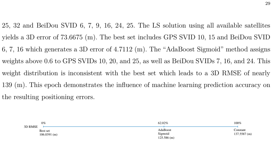
Editorial analysis
A structured set of objections, weighed in public.
Referee Report
Summary. The manuscript proposes a machine learning framework to enhance weighted least squares (WLS) GNSS positioning in urban environments. Ensemble models are trained on signal quality indicators (C/N0, elevation, pseudorange residuals) to output quality scores per satellite; these scores are mapped through activation functions (sigmoid performing best) to produce weights for the WLS solution. Real-world datasets from Hong Kong and Tokyo are used to demonstrate substantial positioning error reductions in single- and multi-constellation cases, plus geographical transferability when models trained on one city are applied to the other.
Significance. If the empirical gains prove robust, the approach could supply a practical, data-driven improvement to GNSS accuracy in dense urban settings by down-weighting degraded signals more effectively than conventional heuristics. The integration of activation functions for weight mapping and the reported cross-city transferability are potentially useful contributions for real-world deployment.
major comments (2)
- [Abstract and Evaluation] Abstract and results sections: the central claims of 'substantial reductions in positioning errors' and 'strong geographical transferability' are presented without quantitative error statistics, error bars, baseline definitions, or details on data exclusion/cross-validation. This information is load-bearing for assessing whether the reported improvements exceed standard elevation/SNR weighting.
- [Methodology and Results] Methodology and results: no direct diagnostics are reported on the correlation between ML-predicted quality scores and ground-truth pseudorange errors or residuals. Without such analysis it remains unclear whether the activation-mapped weights meaningfully reflect per-satellite error contributions rather than simply reweighting in a training-distribution-dependent manner.
minor comments (2)
- [Abstract] Abstract: 'comparative analysis of activation functions' is mentioned but the set of functions tested (beyond sigmoid) is not enumerated.
- [Throughout] Notation: ensure consistent terminology for 'quality scores' versus 'weights' across sections to prevent reader confusion.
Simulated Author's Rebuttal
We thank the referee for their thorough review and constructive feedback on our manuscript. We have addressed each of the major comments in detail below and made revisions to the manuscript to improve clarity and completeness.
read point-by-point responses
-
Referee: [Abstract and Evaluation] Abstract and results sections: the central claims of 'substantial reductions in positioning errors' and 'strong geographical transferability' are presented without quantitative error statistics, error bars, baseline definitions, or details on data exclusion/cross-validation. This information is load-bearing for assessing whether the reported improvements exceed standard elevation/SNR weighting.
Authors: We agree that the abstract would benefit from more specific quantitative details to support the claims. The results section already provides quantitative error statistics, including positioning RMSE values for various scenarios and comparisons against baseline weighting methods such as elevation-only and C/N0-based weighting. We have revised the abstract to include specific error reduction figures (e.g., average improvements observed) and added details on the cross-validation procedure and data exclusion criteria used in the experiments. Additionally, we have included error bars in the revised figures and text to indicate variability. These changes ensure the claims are better supported and allow direct comparison to standard methods. revision: yes
-
Referee: [Methodology and Results] Methodology and results: no direct diagnostics are reported on the correlation between ML-predicted quality scores and ground-truth pseudorange errors or residuals. Without such analysis it remains unclear whether the activation-mapped weights meaningfully reflect per-satellite error contributions rather than simply reweighting in a training-distribution-dependent manner.
Authors: This is a valid point. To address it, we have added a new analysis in the results section showing the correlation between the machine learning predicted quality scores and the ground-truth pseudorange residuals. This includes computed correlation coefficients and visualizations demonstrating that lower quality scores correspond to larger residuals, validating that the weights reflect per-satellite error contributions. The cross-city transferability results further support that the approach is not merely overfitting to the training distribution but generalizes to similar urban environments. revision: yes
Circularity Check
No significant circularity: empirical results rest on external GNSS datasets
full rationale
The paper trains ensemble models on real-world signal quality indicators (C/N0, elevation, residuals) from Hong Kong and Tokyo urban recordings to output quality scores, maps them through activation functions (sigmoid reported best) to WLS weights, and evaluates positioning error reductions plus cross-regional transferability directly against measured ground-truth errors in held-out or alternate-region data. No equations, fitted parameters, or self-citations reduce the reported accuracy gains or transferability to quantities defined inside the training loop itself; the central claims are falsifiable against independent positioning benchmarks outside the model's own outputs.
Axiom & Free-Parameter Ledger
free parameters (2)
- Ensemble learning hyperparameters
- Activation function parameters
axioms (1)
- domain assumption Signal quality indicators are informative predictors of pseudorange error severity in urban environments
Lean theorems connected to this paper
-
IndisputableMonolith/Cost/FunctionalEquation.leanwashburn_uniqueness_aczel unclear?
unclearRelation between the paper passage and the cited Recognition theorem.
activation functions are employed to transform the machine learning predicted scores to appropriate weights for WLS positioning... sigmoid(ˆp; a, b) = 1/(1+e^{-b(ˆp-a)})
-
IndisputableMonolith/Foundation/RealityFromDistinction.leanreality_from_one_distinction unclear?
unclearRelation between the paper passage and the cited Recognition theorem.
three ensemble learning techniques... random forest, AdaBoost and gradient boosting... to assess GNSS signal quality scores
What do these tags mean?
- matches
- The paper's claim is directly supported by a theorem in the formal canon.
- supports
- The theorem supports part of the paper's argument, but the paper may add assumptions or extra steps.
- extends
- The paper goes beyond the formal theorem; the theorem is a base layer rather than the whole result.
- uses
- The paper appears to rely on the theorem as machinery.
- contradicts
- The paper's claim conflicts with a theorem or certificate in the canon.
- unclear
- Pith found a possible connection, but the passage is too broad, indirect, or ambiguous to say the theorem truly supports the claim.
Reference graph
Works this paper leans on
-
[1]
Evolution of the global navi gation satellitesystem (gnss),
C. J. Hegarty and E. Chatre, “Evolution of the global navi gation satellitesystem (gnss),” Proceedings of the IEEE, vol. 96, no. 12, pp. 1902–1917, 2009
work page 1902
-
[2]
C. Fernandez-Prades, L. L. Presti, and E. Falletti, “Sat ellite radiolocalization from GPS to GNSS and beyond: Novel technologies and applications for civil mass market, ” Proceedings of the IEEE , vol. 99, no. 11, pp. 1882– 1904, 2011
work page 1904
-
[3]
GNSS user technology: State-of-the-art and fut ure trends,
D. Egea-Roca, M. Arizabaleta-Diez, T. Pany, F. Antreich , J. A. Lopez-Salcedo, M. Paonni, and G. Seco- Granados, “GNSS user technology: State-of-the-art and fut ure trends,” IEEE Access, vol. 10, pp. 39 939–39 968, 2022
work page 2022
-
[4]
GNSS smartphones position ing: Advances, challenges, opportunities, and future perspectives,
F. Zangenehnejad and Y. Gao, “GNSS smartphones position ing: Advances, challenges, opportunities, and future perspectives,” Satellite navigation , vol. 2, no. 1, p. 24, 2021
work page 2021
-
[5]
Improving precision gnss positioning and navigation accuracy on smartphones using machine learning ,
A. Siemuri, K. Selvan, H. Kuusniemi, P. V¨ alisuo, and M. S . Elmusrati, “Improving precision gnss positioning and navigation accuracy on smartphones using machine learning ,” in Proceedings of the 34th International Technical Meeting of the Satellite Division of The Institute of Naviga tion (ION GNSS+ 2021) , 2021, pp. 3081–3093
work page 2021
-
[6]
A survey on coopera tive positioning using GNSS measurements,
R. Jin, G. Zhang, L.-T. Hsu, and Y. Hu, “A survey on coopera tive positioning using GNSS measurements,” IEEE Transactions on Intelligent Vehicles , vol. 9, no. 11, pp. 7402–7429, 2024
work page 2024
-
[7]
Research on GNSS INS & GNSS/INS in tegrated navigation method for autonomous vehicles: A survey,
Y. He, J. Li, and J. Liu, “Research on GNSS INS & GNSS/INS in tegrated navigation method for autonomous vehicles: A survey,” IEEE Access, vol. 11, pp. 79 033–79 055, 2023
work page 2023
-
[8]
Real-time performance- focused localization techniques for autonomous vehicle: A review,
Y. Lu, H. Ma, E. Smart, and H. Yu, “Real-time performance- focused localization techniques for autonomous vehicle: A review,” IEEE Transactions on Intelligent Transportation Systems, vol. 23, no. 7, pp. 6082–6100, 2021. 34
work page 2021
-
[9]
O. K. Isik, I. Petrunin, G. Inalhan, A. Tsourdos, R. V. Mor eno, and R. Grech, “A Machine Learning Based GNSS Performance Prediction for Urban Air Mobility Using En vironment Recognition,” in 2021 IEEE/AIAA 40th Digital Avionics Systems Conference , Oct. 2021, pp. 1–5
work page 2021
-
[10]
Analysis and modeling GPS NLOS effect in high ly urbanized area,
L.-T. Hsu, “Analysis and modeling GPS NLOS effect in high ly urbanized area,” GPS Solutions , vol. 22, no. 1, p. 7, Nov. 2017. [Online]. A vailable: https://doi.org/10. 1007/s10291-017-0667-9
work page 2017
-
[11]
P. D. Groves and Z. Jiang, “Height Aiding, C/N0 Weightin g and Consistency Checking for GNSS NLOS and Multipath Mitigation in Urban Areas,” The Journal of Navigation , vol. 66, no. 5, pp. 653–669, Sep. 2013
work page 2013
-
[12]
P. J. Teunissen and O. Montenbruck, Eds., Springer Handbook of Global Navigation Satellite Systems . Cham: Springer International Publishing, 2017, pp. 3-23, 433-43 4, 444-503, 639-660
work page 2017
-
[13]
I nfluence of Satellite Geometry and Differential Correction on GPS Location Accuracy,
C. Dussault, R. Courtois, J.-P. Ouellet, and J. Huot, “I nfluence of Satellite Geometry and Differential Correction on GPS Location Accuracy,” Wildlife Society Bulletin (1973-2006) , vol. 29, no. 1, pp. 171–179, 2001
work page 1973
-
[14]
GNSS NLOS Signal Classification Ba sed on Machine Learning and Pseudorange Residual Check,
T. Ozeki and N. Kubo, “GNSS NLOS Signal Classification Ba sed on Machine Learning and Pseudorange Residual Check,” Frontiers in Robotics and AI , vol. 9, May 2022, art. no. 868608
work page 2022
-
[15]
LOS/NLOS Classification Using Scenario- Dependent Unsupervised Machine Learning,
A. Kirmaz, D. S. Michalopoulos, I. Balan, and W. Gerstac ker, “LOS/NLOS Classification Using Scenario- Dependent Unsupervised Machine Learning,” in 2021 IEEE 32nd Annual International Symposium on Personal, Indoor and Mobile Radio Communications (PIMRC) , Sep. 2021, pp. 1134–1140
work page 2021
-
[16]
NLOS Multipath Classification o f GNSS Signal Correlation Output Using Machine Learning,
T. Suzuki and Y. Amano, “NLOS Multipath Classification o f GNSS Signal Correlation Output Using Machine Learning,” Sensors, vol. 21, no. 7, Jan. 2021, art. no. 2503
work page 2021
-
[17]
L. Li, M. Elhajj, Y. Feng, and W. Y. Ochieng, “Machine lea rning based GNSS signal classification and weighting scheme design in the built environment: a comparative exper iment,” Satellite Navigation , vol. 4, no. 1, May 2023, art. no. 12
work page 2023
-
[18]
Robust design of a machine learning-based GNSS NLOS detector with multi-frequency features,
O. Garc ´ ıa Crespillo, J. C. Ruiz-Sicilia, A. Kliman, an d J. Marais, “Robust design of a machine learning-based GNSS NLOS detector with multi-frequency features,” Frontiers in Robotics and AI , vol. 10, Jul. 2023, art. no. 1171255
work page 2023
-
[19]
S. Ali, T. Abuhmed, S. El-Sappagh, K. Muhammad, J. M. Alo nso-Moral, R. Confalonieri, R. Guidotti, J. Del Ser, N. D ´ ıaz-Rodr ´ ıguez, and F. Herrera, “Explainable Artifici al Intelligence (XAI): What we know and what is left to attain Trustworthy Artificial Intelligence,” Information Fusion, vol. 99, Nov. 2023, art. no. 101805
work page 2023
-
[20]
L. Li, Z. Xu, Z. Jia, L. Lai, and Y. Shen, “An efficient GNSS N LOS signal identification and processing method using random forest and factor analysis with visual labels, ” GPS Solutions , vol. 28, no. 2, p. 77, Feb. 2024
work page 2024
-
[21]
Machin e learning based LOS/NLOS classifier and robust estimator for GNSS shadow matching,
H. Xu, A. Angrisano, S. Gaglione, and L.-T. Hsu, “Machin e learning based LOS/NLOS classifier and robust estimator for GNSS shadow matching,” Satellite Navigation , vol. 1, no. 1, May 2020, art. no. 15
work page 2020
-
[22]
ML-based LOS/NLOS/multipath signal classifiers for GNSS in simulated multipath environment,
S. R. S. J. Koiloth, D. S. Achanta, and P. R. Koppireddi, “ ML-based LOS/NLOS/multipath signal classifiers for GNSS in simulated multipath environment,” Aerospace Systems, vol. 7, no. 2, pp. 237–250, Jun. 2024
work page 2024
-
[23]
A. Tabatabaei, M. R. Mosavi, A. Khavari, and H. S. Shahho seini, “Reliable Urban Canyon Navigation Solution in GPS and GLONASS Integrated Receiver Using Improved Fuzzy Weighted Least-Square Method,” Wireless Personal Communications, vol. 94, no. 4, pp. 3181–3196, Jun. 2017
work page 2017
-
[24]
H.-F. Ng, G. Zhang, K.-Y. Yang, S.-X. Yang, and L.-T. Hsu , “Improved weighting scheme using consumer-level GNSS L5/E5a/B2a pseudorange measurements in the urban area ,” Advances in Space Research, vol. 66, no. 7, pp. 1647–1658, Oct. 2020
work page 2020
-
[25]
M. A. Akram, P. Liu, Y. Wang, and J. Qian, “GNSS Positioni ng Accuracy Enhancement Based on Robust Statistical MM Estimation Theory for Ground Vehicles in Cha llenging Environments,” Applied Sciences, vol. 8, no. 6, p. 876, Jun. 2018, number: 6 Publisher: Multidiscipli nary Digital Publishing Institute. 35
work page 2018
-
[26]
Doppler-Aided GNSS Positi on Estimation With Weighted Least Squares,
L. Li, J. Zhong, and M. Zhao, “Doppler-Aided GNSS Positi on Estimation With Weighted Least Squares,” IEEE Transactions on Vehicular Technology, vol. 60, no. 8, pp. 3615–3624, Oct. 2011
work page 2011
-
[27]
A Combined Elevation Angle and C /N0 Weighting Method for GNSS PPP on Xiaomi MI8 Smartphones,
Y. Li, C. Cai, and Z. Xu, “A Combined Elevation Angle and C /N0 Weighting Method for GNSS PPP on Xiaomi MI8 Smartphones,” Sensors, vol. 22, no. 7, p. 2804, Apr. 2022
work page 2022
-
[28]
The Improvement of Positioning Accurac y with Weighted Least Square Based on SNR,
J. Li and M. Wu, “The Improvement of Positioning Accurac y with Weighted Least Square Based on SNR,” in 2009 5th International Conference on Wireless Communicati ons, Networking and Mobile Computing , Sep. 2009, pp. 1–4, iSSN: 2161-9654
work page 2009
-
[29]
Z. Lyu and Y. Gao, “An SVM Based Weight Scheme for Improvi ng Kinematic GNSS Positioning Accuracy with Low-Cost GNSS Receiver in Urban Environments,” Sensors, vol. 20, no. 24, p. 7265, Dec. 2020
work page 2020
-
[30]
Machine learning based multi-co nstellation satellite selection algorithm in urban area,
P.-H. Lee and H. Leib, “Machine learning based multi-co nstellation satellite selection algorithm in urban area,” in AIAA/DATC IEEE 44th Digital Avionics Systems Conference (D ASC), 2025, pp. 1–10
work page 2025
-
[31]
Machine Learning Techniques for Multi-GNS S Positioning,
P.-H. Lee, “Machine Learning Techniques for Multi-GNS S Positioning,” Master’s thesis, McGill University, Montreal, Quebec, Canada, October 2025
work page 2025
-
[32]
P. D. Groves, Principles of GNSS, Inertial, and Multisensor Integrated N avigation Systems , 2nd ed. Boston: Artech House, Jan. 2013, pp. 349-436
work page 2013
-
[33]
Z. Zhang, B. Li, Y. Shen, Y. Gao, and M. Wang, “Site-Speci fic Unmodeled Error Mitigation for GNSS Positioning in Urban Environments Using a Real-Time Adaptive Weighting Model,” Remote Sensing , vol. 10, no. 7, Jul. 2018, art. no. 1157
work page 2018
-
[34]
A Modified Satellite Sel ection Algorithm Based on Satellite Contribution for GDOP in GNSS,
G. Li, C. Xu, P. Zhang, and C. Hu, “A Modified Satellite Sel ection Algorithm Based on Satellite Contribution for GDOP in GNSS,” in Advances in Mechanical and Electronic Engineering , D. Jin and S. Lin, Eds. Berlin, Heidelberg: Springer, 2012, pp. 415–421
work page 2012
-
[35]
R. Yarlagadda, I. Ali, N. Al-Dhahir, and J. Hershey, “GP S GDOP metric,” IEE Proc. - Radar, Sonar and Navig. , vol. 147, no. 5, pp. 259–264, Oct. 2000
work page 2000
-
[36]
Identifying a low -frequency oscillation in Galileo IOV pseudorange rates,
D. Borio, C. Gioia, and N. Mitchison, “Identifying a low -frequency oscillation in Galileo IOV pseudorange rates,” GPS Solutions , vol. 20, no. 3, pp. 363–372, Jul. 2016
work page 2016
-
[37]
GNSS multipath detection using a machine le arning approach,
L.-T. Hsu, “GNSS multipath detection using a machine le arning approach,” in 2017 IEEE 20th International Conference on Intelligent Transportation Systems , Oct. 2017, pp. 1–6
work page 2017
-
[38]
I. Goodfellow, Y. Bengio, and A. Courville, Deep Learning. Cambridge, Mass: The MIT Press, 2016, pp. 1-28
work page 2016
-
[39]
A. Kumar and M. Jain, Ensemble Learning for AI Developers: Learn Bagging, Stacki ng, and Boosting Methods with Use Cases . Berkeley, CA: Apress Publishers, 2020, pp. 11-29, 49-60
work page 2020
-
[40]
Bonaccorso, Mastering Machine Learning Algorithms - Second Edition , 2nd ed
G. Bonaccorso, Mastering Machine Learning Algorithms - Second Edition , 2nd ed. Birmingham: Packt Publishing, Jan. 2020
work page 2020
-
[41]
Alpaydin, Introduction to Machine Learning, fourth edition , 4th ed
E. Alpaydin, Introduction to Machine Learning, fourth edition , 4th ed. Cambridge, Massachusetts London: The MIT Press, Mar. 2020, pp. 173-180, 351-372
work page 2020
-
[42]
Zhou, Machine Learning, 1st ed
Z.-H. Zhou, Machine Learning, 1st ed. Singapore: Springer, Aug. 2022, pp. 79-102, 181-21 0
work page 2022
-
[43]
Chapman & Hall/CRC, May 2012, pp
——, Ensemble Methods: Foundations and Algorithms , 1st ed. Chapman & Hall/CRC, May 2012, pp. 23-46
work page 2012
-
[44]
A Decision-Theoretic Gen eralization of On-Line Learning and an Application to Boosting,
Y. Freund and R. E. Schapire, “A Decision-Theoretic Gen eralization of On-Line Learning and an Application to Boosting,” Journal of Computer and System Sciences , vol. 55, no. 1, pp. 119–139, Aug. 1997
work page 1997
-
[45]
Greedy function approximation: A grad ient boosting machine
J. H. Friedman, “Greedy function approximation: A grad ient boosting machine. ” The Annals of Statistics, vol. 29, no. 5, pp. 1189–1232, Oct. 2001
work page 2001
-
[46]
On the information 36 bottleneck theory of deep learning,
A. M. Saxe, Y. Bansal, J. Dapello, M. Advani, A. Kolchins ky, B. D. Tracey, and D. D. Cox, “On the information 36 bottleneck theory of deep learning,” Journal of Statistical Mechanics: Theory and Experiment , vol. 2019, no. 12, p. 124020, Dec. 2019
work page 2019
-
[47]
Activatio n functions in deep learning: A comprehensive survey and benchmark,
S. R. Dubey, S. K. Singh, and B. B. Chaudhuri, “Activatio n functions in deep learning: A comprehensive survey and benchmark,” Neurocomputing, vol. 503, pp. 92–108, Sep. 2022
work page 2022
-
[48]
ACTIV ATION FUNCT IONS IN NEURAL NETWORKS,
S. Sharma, S. Sharma, and A. Athaiya, “ACTIV ATION FUNCT IONS IN NEURAL NETWORKS,” Interna- tional Journal of Engineering Applied Sciences and Technol ogy, vol. 04, no. 12, pp. 310–316, May 2020
work page 2020
-
[49]
L.-T. Hsu, F. Huang, H.-F. Ng, G. Zhang, Y. Zhong, X. Bai, and W. Wen, “Hong Kong UrbanNav: An Open- Source Multisensory Dataset for Benchmarking Urban Naviga tion Algorithms,” NA VIGATION: Journal of the Institute of Navigation , vol. 70, no. 4, Dec. 2023
work page 2023
-
[50]
Canadian Spatial Referenc e System Precise Point Positioning (CSRS-PPP)
Natural Resources Canada, “Canadian Spatial Referenc e System Precise Point Positioning (CSRS-PPP). ” [Online]. A vailable: https://webapp.csrs-scrs.nrcan-rncan.gc.ca/geod/tools-outils/ppp.php
discussion (0)
Sign in with ORCID, Apple, or X to comment. Anyone can read and Pith papers without signing in.