REVIEW 4 major objections 5 minor 29 references
Multi-Point Proximity Encoding For Vector-Mode Geospatial Machine Learning
T0 review · 4 major / 5 minor · reviewed 2026-08-07 · deepseek-v4-flash
Pith's one-line read This paper claims that Multi-Point Proximity encoding—scaled distances from a shape to fixed reference points—represents points, lines, and polygons for machine learning and beats rasterization in every test.
desk verdict A clean, honest extension of GPS2Vec to arbitrary vector geometries, with a plausible empirical win over a weak raster baseline; the paper deserves review but the broad 'beats rasterization' claim needs a stronger baseline and released artifacts. read the letter →
The pith
A machine-rendered reading of the paper's core claim, the machinery that carries it, and where it could break.
The reading
What carries the argument
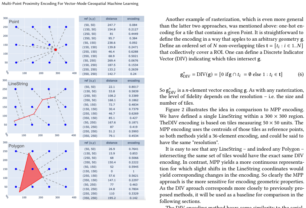
The load-bearing object is the MPP formula itself, $\mathrm{MPP}(g) = [\exp(-\mathrm{dist}(g, r_i)/s)]$, where $\mathrm{dist}(g, r_i)$ is the minimum Euclidean distance from reference point $r_i$ to any point of the geometry and $s$ is a scaling factor. The negative exponential kernel maps distances into $(0,1]$ and makes nearby reference points dominate the representation. Because the distance is taken to the geometry as a set, the same formula handles points, lines, polygons, and their multi-part collections without modification; because the kernel is a continuous monotone function of distance, small shape perturbations change the encoding smoothly, unlike the discrete jumps of tile-membership vectors.
What would settle it
Train a convolutional network on the DIV (raster) encodings at matched or higher resolution and compare ROC AUC and $R^2$ against the two-layer MLP on MPP; if the CNN reaches or exceeds MPP's scores, the paper's central claim fails. A second check is to construct two different geometries that produce identical MPP vectors at a coarse grid and show a pairwise relationship the encoding cannot separate.
Extended reading notes
Core claim
The central discovery is that the kernel used for point-location encoding works unchanged for arbitrary geometries if distance is redefined as minimum distance from the geometry to each reference point. The resulting encoding, $\mathrm{MPP}(g) = [\exp(-\mathrm{dist}(g, r_i)/s) : r_i \in \mathbf{r}]$, lies in $(0,1]$, is continuous with respect to infinitesimal shape changes, and is invariant to vertex ordering and redundant vertices. From an MPP vector one can invert each element to recover an exclusion-zone distance, so the encoding is a lower-resolution snapshot of the shape rather than a one-hot membership pattern. In the paper's experiments, two-layer MLPs trained on MPP vectors recover geometric properties and pairwise spatial relationships with higher $R^2$ and ROC AUC than the same models trained on rasterization-style indicator vectors, and MPP retains its advantage as resolution coarsens.
Load-bearing premise
The comparison rests on the assumption that the same two-layer MLP decoder and equal grid counts are fair ways to compare MPP with rasterization; if a stronger raster-based model or a different resolution-matching rule would flip the ranking, the claim that MPP is clearly more capable collapses.
Editorial extensions
If this is right
- A single encoder can feed points, lines, and polygons into the same neural-network, clustering, or regression pipeline, so models no longer need separate handling per geometry type.
- Because MPP stays informative at coarser reference-point spacings, applications can use shorter vectors, reducing storage and computation with less loss than rasterization suffers.
- The continuity of MPP means gradient-based models can be trained end-to-end on encoded coordinates: small changes in geometry produce small changes in the encoding, so backpropagation through the encoder is well-behaved.
- Pairwise spatial predicates such as point-in-polygon and intersection are recoverable from concatenated MPP encodings with ROC AUC above 0.95 in nearly all tested cases, suggesting the encoding preserves enough relational geometry for many analysis tasks.
Reading between the lines
- Beyond the paper: the same formula could sit in front of a triplet-loss or contrastive embedding model, giving a continuous differentiable spatial context for self-supervised geospatial representation learning.
- Beyond the paper: replacing the rectangular reference grid with a global hexagonal grid would turn MPP into a candidate worldwide shape encoder, with thresholding of small values keeping the vectors sparse.
- Beyond the paper: a direct stress test would match MPP and raster encodings by information content rather than by equal vector length, and would give the raster model a convolutional decoder; the paper's fixed two-layer MLP may understate what rasterization can do.
Editorial analysis
A structured set of objections, weighed in public.
Referee Report
Summary. The paper introduces Multi-Point Proximity (MPP) encoding, which represents any vector geometry (Point, LineString, Polygon) as a vector of negative-exponential scaled minimum distances to a fixed grid of reference points. It defines a baseline, Discrete Indicator Vector (DIV), that marks which raster cells intersect the geometry. The authors argue that MPP is shape-centric and continuous, demonstrate clustering of encoded shapes, and evaluate both encodings by training a two-layer MLP to predict single-shape properties (length, area, orientation, sinuosity, CHAR) and pairwise spatial relations, reporting R^2 and ROC AUC respectively. The central claim is that MPP outperforms the rasterization-based DIV in all tested cases.
Significance. The idea of reusing GPS2Vec-style kernel encoding for arbitrary geometries is a natural and potentially useful contribution; it yields a fixed-size, continuous, shape-centric vector that is directly usable by standard ML models. The evaluation framework, based on regression/classification from encodings to known geometric properties, is a reasonable way to compare representations. If the claimed universal superiority over rasterization is established, MPP would be a simple general-purpose alternative to raster-based encodings. However, the current evidence is not yet load-bearing: the baseline is a single binary rasterization scheme, no uncertainty quantification is reported, and the key plots are not inspectable in the manuscript text. These gaps prevent a journal-level endorsement of the broad claim.
major comments (4)
- [Section 2.2 and Section 4] The paper's main claim, that MPP encoding is 'clearly more capable' than an approach based on rasterization, is supported only by comparison against DIV (Eq. 6), a binary occupancy indicator. DIV discards continuous distance information, so the experiments largely demonstrate that a real-valued distance encoding beats a one-bit occupancy encoding under the same MLP decoder. A continuous-distance raster, or a convolutional decoder that exploits grid structure, is a natural raster-based baseline and is absent. Please add such baselines, or narrow the claim to 'better than one-hot DIV under a fixed MLP decoder.'
- [Section 3.3.1, Figure 7 and Section 3.3.2, Figure 8] No numeric results, error bars, confidence intervals, or repeated trials are reported. The R^2 and ROC AUC curves are the sole evidence for the central claim, and without uncertainty estimates or a table of values, the reader cannot assess whether MPP's advantage is significant or stable. Please report point estimates from multiple random seeds, plus standard deviations, for each resolution and metric.
- [Section 2.2, Figure 2 and Table 1] The resolution-matching rule (equal number of reference points and cells) is not an information-fair comparison. A single MPP element is a real value in (0,1], while a single DIV element is a bit; equal vector lengths do not imply equal information content. This may inflate MPP's apparent advantage. Please discuss or control for information content (e.g., total bits/bytes, or a DIV baseline with per-cell continuous distance values).
- [Section 2.1, Eq. (5) and Section 3.3.1] The scaling factor s is a free parameter set equal to the reference-point spacing and never varied. Since the kernel width determines how much the encoding depends on distant reference points, the reported MPP results could be sensitive to this choice. Please provide a sensitivity analysis for s or a principled selection rule (e.g., cross-validation), especially at coarser resolutions where the ratio of s to relevant distances changes.
minor comments (5)
- [Section 3.1] The inversion formula should read d_i = -s ln g_i; the current typesetting '-ln g_i / s' is ambiguous and likely missing a factor of s.
- [Throughout] There are numerous typographical errors: 'raser-mode' should be 'raster-mode', 'endode' should be 'encode', 'repectively' should be 'respectively', 'Mulltipolygon' should be 'MultiPolygon', and 'continutity' should be 'continuity'.
- [Section 2.3] The sentence 'these shapes occupy overlap one another within the reference frame' is ungrammatical and should be rephrased.
- [Section 3.3.1] The phrase 'To prove that an encoding captures some geometric property' is stronger than what the experiments establish; the experiments show that a trained model can predict the property from the encoding, which is evidence of capturability, not a proof.
- [Figures 7 and 8] The actual plots for Figures 7 and 8 are not visible in the manuscript text provided; please ensure the compiled PDF contains legible plots with axis labels, legends, and numeric values where feasible.
Circularity Check
No significant circularity: MPP is an externally defined encoding and all empirical claims are tested on held-out data.
full rationale
The paper's central claim is that Multi-Point Proximity encoding outperforms a rasterization-based DIV baseline. This is an empirical comparison, not a derivation from the encoding's own definition. The MPP encoding is defined externally in Eq. 5 as an exponential function of distance to reference points, adapted from the cited GPS2Vec method; it is not defined in terms of the geometric properties or pairwise relationships used as prediction targets. The evaluation trains fixed two-layer MLPs on disjoint training/validation/test splits, with ground-truth properties computed directly from vector geometries rather than from the encodings. The scaling factor s is set equal to the reference-point spacing as a stated modeling choice, not fitted to the test outcomes. The continuity and shape-centricity arguments follow analytically from Eqs. 4-6 and are not circular. There are no self-citations by the author that carry load-bearing weight; all cited prior work is external. The DIV baseline is limited to binary occupancy indicators, and one could question whether the comparison generalizes to all rasterization-based methods, but that is a concern about experimental scope and fairness, not circularity. No step in the paper reduces by construction to its own inputs, and no fitted parameter is renamed as a prediction.
Assumptions & free parameters
free parameters (1)
- scaling factor s =
equal to reference point spacing (e.g., 100 in examples)
assumptions (3)
- domain assumption Minimum distance from a shape to a reference point, as defined in Eq. 4, is a sufficient geometric primitive for encoding arbitrary shapes.
- ad hoc to paper A neural network's test performance on predicting known properties is a valid proxy for the information content of an encoding.
- domain assumption The randomly transformed OSM geometries from the northeastern US are representative of general vector geospatial data.
Cite this review
Pith. "Pith review of Multi-Point Proximity Encoding For Vector-Mode Geospatial Machine Learning." pith.science (2026). https://pith.science/paper/WQTRKTWU
@misc{pith2026250605016,
  author       = {Pith},
  title        = {Pith review of: Multi-Point Proximity Encoding For Vector-Mode Geospatial Machine Learning},
  year         = {2026},
  howpublished = {\url{https://pith.science/paper/WQTRKTWU}},
  note         = {Machine review of arXiv:2506.05016}
}
read the original abstract
Vector-mode geospatial data -- points, lines, and polygons -- must be encoded into an appropriate form in order to be used with traditional machine learning and artificial intelligence models. Encoding methods attempt to represent a given shape as a vector that captures its essential geometric properties. This paper presents an encoding method based on scaled distances from a shape to a set of reference points within a region of interest. The method, MultiPoint Proximity (MPP) encoding, can be applied to any type of shape, enabling the parameterization of machine learning models with encoded representations of vector-mode geospatial features. We show that MPP encoding possesses the desirable properties of shape-centricity and continuity, can be used to differentiate spatial objects based on their geometric features, and can capture pairwise spatial relationships with high precision. In all cases, MPP encoding is shown to perform better than an alternative method based on rasterization.
Figures


Figures from the paper (5 more)


Reference graph
Works this paper leans on
- [1]
-
[2]
Qi Charles, Hao Su, Mo Kaichun, and Leonidas J
R. Qi Charles, Hao Su, Mo Kaichun, and Leonidas J. Guibas. 2017. PointNet: Deep Learning on Point Sets for 3D Classification and Segmentation. In 2017 IEEE Conference on Computer Vision and Pattern Recognition (CVPR) . IEEE, New York, NY, USA, 77–85. doi:10.1109/CVPR.2017.16
-
[3]
Longfei Cui, Xinyu Niu, Haizhong Qian, Xiao Wang, and Junkui Xu. 2025. A Transformer-Based Approach for Efficient Geometric Feature Extraction from Vector Shape Data. Applied Sciences 15, 5 (2025). doi:10.3390/app15052383
-
[4]
Anil B. Gavade and Priyanka A. Gavade. 2025. Explainable AI in Transforming Land Use Land Cover Classification. Springer Nature Switzerland, Cham, 343–356. doi:10.1007/978-3-031-75968-0_18
-
[5]
Elad Hoffer and Nir Ailon. 2015. Deep Metric Learning Using Triplet Network. In Similarity-Based Pattern Recognition, Aasa Feragen, Marcello Pelillo, and Marco Loog (Eds.). Springer International Publishing, Cham, 84–92
work page 2015
-
[6]
Neal Jean, Sherrie Wang, Anshul Samar, George Azzari, David Lobell, and Stefano Ermon. 2019. Tile2Vec: Unsupervised Representation Learning for Spatially Distributed Data. Proceedings of the AAAI Conference on Artificial Intelligence 33, 01 (Jul. 2019), 3967–3974. doi:10.1609/aaai.v33i01.33013967
-
[7]
Ioannis Kotaridis and Maria Lazaridou. 2021. Remote sensing image segmentation advances: A meta-analysis. ISPRS Journal of Photogrammetry and Remote Sensing 173 (2021), 309–322. doi:10.1016/j.isprsjprs.2021.01.020
-
[8]
Alex Krizhevsky, Ilya Sutskever, and Geoffrey E. Hinton. 2017. ImageNet classi- fication with deep convolutional neural networks. Commun. ACM 60, 6 (May 2017), 84–90. doi:10.1145/3065386 Multi-Point Proximity Encoding For Vector-Mode Geospatial Machine Learning Figure 8: Estimation of pairwise geometric relationships from MPP and DIV encodings
doi:10.1145/3065386 2017
Show all 29 references
-
[9]
Lei Ma, Manchun Li, Xiaoxue Ma, Liang Cheng, Peijun Du, and Yongxue Liu
-
[10]
Gengchen Mai, Krzysztof Janowicz, Ling Cai, Rui Zhu, Blake Regalia, Bo Yan, Meilin Shi, and Ni Lao. 2020. SE-KGE: A location-aware Knowledge Graph Embedding model for Geographic Question Answering and Spatial Seman- tic Lifting. Transactions in GIS 24, 3 (2020), 623–655. doi:1...
2020 doi
-
[11]
Gengchen Mai, Krzysztof Janowicz, Yingjie Hu, Song Gao, Bo Yan, Rui Zhu, Ling Cai, and Ni Lao. 2021. A Review of Location Encoding for GeoAI: Methods and Applications. International Journal of Geographical Information Science abs/2111.04006 (2021), 32 pages. arXiv:2111.04006 h...
2021 arXiv
-
[12]
Gengchen Mai, Krzysztof Janowicz, Bo Yan, Rui Zhu, Ling Cai, and Ni Lao. 2020. Multi-Scale Representation Learning for Spatial Feature Distributions using Grid Cells. arXiv:2003.00824 https://arxiv.org/abs/2003.00824
2020 arXiv
-
[13]
Gengchen Mai, Yiqun Xie, Xiaowei Jia, Ni Lao, Jinmeng Rao, Qing Zhu, Zeping Liu, Yao-Yi Chiang, and Junfeng Jiao. 2025. Towards the next generation of Geospatial Artificial Intelligence. International Journal of Applied Earth Observa- tion and Geoinformation 136 (2025), 104368...
2025
-
[14]
Gengchen Mai, Xiaobai Yao, Yiqun Xie, Jinmeng Rao, Hao Li, Qing Zhu, Ziyuan Li, and Ni Lao. 2024. SRL: Towards a General-Purpose Framework for Spatial Representation Learning. InProceedings of the 32nd ACM International Conference on Advances in Geographic Information Systems ...
2024
-
[15]
Terence Darlington Mushore, John Odindi, Timothy Dube, Trylee Nyasha Ma- tongera, and Onisimo Mutanga. 2017. Remote sensing applications in mon- itoring urban growth impacts on in-and-out door thermal conditions: A re- view. Remote Sensing Applications: Society and Environment...
2017 doi
-
[16]
Sentiance NV. n.d.. Loc2Vec: Learning location embeddings with triplet-loss networks. https://www.sentiance.com/2018/05/03/venue-mapping/
2018
-
[17]
Open Geospatial Consortium. 2011. OpenGIS® Implementation Standard for Geographic information – Simple feature access – Part 1: Common architecture . Technical Report OGC 06-103r4. Open Geospatial Consortium. http://www. opengeospatial.org/standards/sfa Annex B specifies the W...
2011
-
[18]
Open Geospatial Consortium. 2011. OpenGIS® Implementation Standard for Geographic Information – Simple Feature Access – Part 1: Common Architecture . Technical Report OGC 06-103r4. Open Geospatial Consortium. http://www. opengeospatial.org/standards/sfa
2011
-
[19]
Joseph Redmon, Santosh Divvala, Ross Girshick, and Ali Farhadi. 2016. You Only Look Once: Unified, Real-Time Object Detection. arXiv:1506.02640 [cs.CV] https://arxiv.org/abs/1506.02640
2016 arXiv
-
[20]
Kevin Sahr. 2011. Hexagonal discrete global grid systems for geospatial com- puting. Archives of Photogrammetry, Cartography and Remote Sensing 22 (01 2011)
2011
-
[21]
Kevin Tang, Manohar Paluri, Li Fei-Fei, Rob Fergus, and Lubomir Bourdev. 2015. Improving Image Classification with Location Context . In2015 IEEE International Conference on Computer Vision (ICCV) . IEEE Computer Society, Los Alamitos, CA, USA, 1008–1016. doi:10.1109/ICCV.2015.121
2015 doi
-
[22]
W. R. Tobler. 1970. A Computer Movie Simulating Urban Growth in the Detroit Region. Economic Geography 46, sup1 (1970), 234–240. doi:10.2307/143141
1970 doi
-
[23]
Gomez, Łukasz Kaiser, and Illia Polosukhin
Ashish Vaswani, Noam Shazeer, Niki Parmar, Jakob Uszkoreit, Llion Jones, Aidan N. Gomez, Łukasz Kaiser, and Illia Polosukhin. 2017. Attention is all you need. In Proceedings of the 31st International Conference on Neural Information Processing Systems (Long Beach, California, ...
2017
-
[24]
Zhecheng Wang, Haoyuan Li, and Ram Rajagopal. 2020. Urban2Vec: Incorpo- rating Street View Imagery and POIs for Multi-Modal Urban Neighborhood Embedding. arXiv:2001.11101 [cs.LG] https://arxiv.org/abs/2001.11101
2020 arXiv
-
[25]
Szymon Woźniak and Piotr Szymański. 2021. hex2vec: Context-Aware Embed- ding H3 Hexagons with OpenStreetMap Tags. In Proceedings of the 4th ACM SIGSPATIAL International Workshop on AI for Geographic Knowledge Discovery (SIGSPATIAL ’21). ACM, New York City, NY, USA, 61–71. doi:...
2021 doi
-
[26]
Yanyu Xu, Zhixin Piao, and Shenghua Gao. 2018. Encoding Crowd Interaction with Deep Neural Network for Pedestrian Trajectory Prediction. In2018 IEEE/CVF Conference on Computer Vision and Pattern Recognition . IEEE, Salt Lake City, UT, USA, 5275–5284. doi:10.1109/CVPR.2018.00553
2018
-
[27]
Yifang Yin, Zhenguang Liu, Ying Zhang, Sheng Wang, Rajiv Ratn Shah, and Roger Zimmermann. 2019. GPS2Vec: Towards Generating Worldwide GPS Em- beddings. In Proceedings of the 27th ACM SIGSPATIAL International Conference on Advances in Geographic Information Systems (Chicago, IL...
2019
-
[28]
Xiangrong Zhang, Tianyang Zhang, Guanchun Wang, Peng Zhu, Xu Tang, Xiup- ing Jia, and Licheng Jiao. 2023. Remote Sensing Object Detection Meets Deep Learning: A Meta-review of Challenges and Advances. arXiv:2309.06751 [cs.CV] https://arxiv.org/abs/2309.06751
2023 arXiv
-
[2017]
ISPRS Journal of Photogrammetry and Remote Sensing 130 (2017), 277–293
A review of supervised object-based land-cover image classification. ISPRS Journal of Photogrammetry and Remote Sensing 130 (2017), 277–293. doi:10.1016/ j.isprsjprs.2017.06.001
2017
Reviewed August 7, 2026 · model on record in the stance chip above.
Discussion (0). Sign in to comment.