REVIEW 3 major objections 5 minor 27 references
Environment Modeling Based on Generic Infrastructure Sensor Interfaces Using a Centralized Labeled-Multi-Bernoulli Filter
T0 review · 3 major / 5 minor · reviewed 2026-08-14 · deepseek-v4-flash
Pith's one-line read This paper claims that a centralized multi-object filter can infer unmeasured vehicle extents from sparse position measurements, as long as distributed sensors observe different corners of the same object.
desk verdict Sensible extension of LMB to partial feature measurements with a clear reference-point model, but the headline extent-inference claim is under-supported: one jittery run, no extent-error statistics, and a greedy vertex selection that can lock onto the wrong corner. read the letter →
The pith
A machine-rendered reading of the paper's core claim, the machinery that carries it, and where it could break.
The reading
What carries the argument
The load-bearing mechanism is the state-dependent measurement matrix $h(x)$, which maps the object's center state to the measured vertex reference point via the offset matrix $\Delta(x)$ built from the trigonometric function $f(\zeta)$ encoding which corner is seen. Because $h(x)$ depends on orientation and extent, the Unscented Kalman Filter is used to handle the nonlinearity. A companion rule selects, among the three closest corners given the sensor's viewing angle, the one with the smallest Mahalanobis distance between predicted and actual measurement, so the filter does not require the sensor to explicitly transmit the reference point.
What would settle it
A controlled test with several sensors observing a rectangular vehicle from the same side—so that all measurements refer to the same corner or two adjacent corners—should show the filter's width and length estimates never converging beyond their birth defaults, even with many observations. If the estimates nevertheless converge to the true extent, the paper's explanation of the mechanism would be wrong.
Extended reading notes
Core claim
On the paper's own terms, the discovery is that an object's extent does not have to be measured directly: it is already encoded implicitly in the positions of different reference points on the object's boundary. If sensors report which corner of a rectangular vehicle their position measurement refers to (front-left, front-right, back-left, or back-right), then two or more sensors viewing different corners fix the width and length through simple geometry. The filter estimates the most likely corner for each measurement using the sensor's viewing angle and Mahalanobis distance, and feeds that into the LMB update with a state-dependent measurement matrix. The result is that tracks are always complete even when every individual measurement is incomplete.
Load-bearing premise
The entire extent-inference benefit depends on the assumption that each position measurement can be assigned to one of the four corners of a rectangular object, and that different sensors see different corners of the same object.
Editorial extensions
If this is right
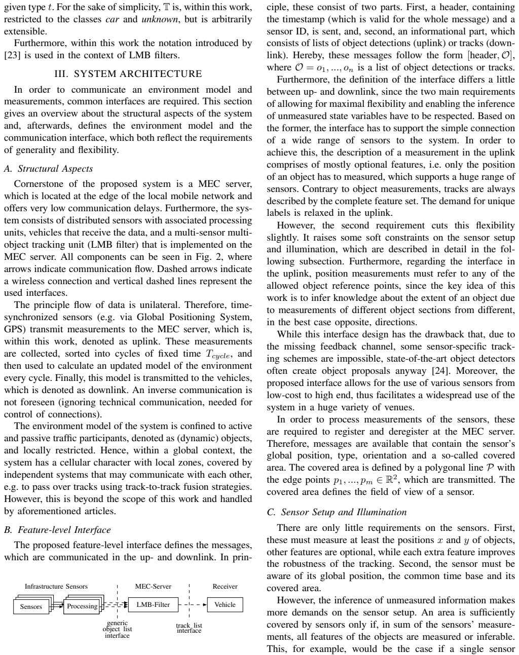
- Infrastructure sensors that only report positions—for example simple lidars or monocular cameras with coarse detection—can be connected through the generic interface and still contribute complete, extent-bearing tracks to the central server.
- Track birth still requires at least one sensor with a full feature vector or a confident class estimate, so a network of position-only sensors alone cannot start tracks; the system design must keep at least one richer sensor per covered area.
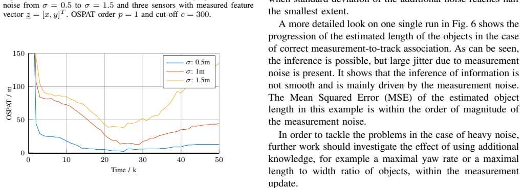
- The simulation results show that position-only measurements are sufficient for reliable tracking at low noise, and that adding explicit width or length measurements stabilizes the estimate against strong noise.
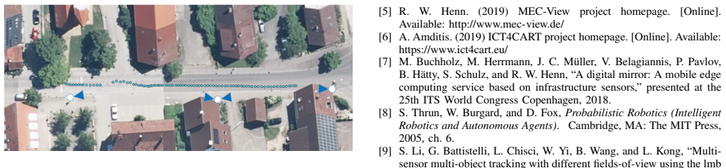
- The real-world demonstration indicates the interface supports heterogeneous sensors with complementary accuracy—cameras precise laterally, lidars longitudinally—yielding a continuous track across multiple fields of view.
Reading between the lines
- The same reference-point geometry could infer shape parameters beyond a rectangle, such as vehicle height, if the object model added a third dimension and sensors reported top and bottom reference points.
- The reliance on corner association suggests a testable extension: quantify how extent estimation degrades as the angular separation between sensors shrinks; near-parallel viewing directions should make width or length gradually unobservable.
- A practical scalability inference is that the generic interface could let existing single-purpose intersection cameras be retrofitted into the system with only a software update that labels which corner of a bounding box the measurement refers to.
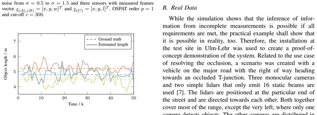
- If the filter's reference-point selection is wrong under heavy noise, the paper's shoulder-shaped OSPAT curve and the jitter in inferred length show that extent errors can persist; an explicit prior on plausible vehicle dimensions would likely reduce this jitter.
Signed reviews
Editorial analysis
A structured set of objections, weighed in public.
Referee Report
Summary. The paper proposes a generic feature-level interface for infrastructure sensors and a centralized Labeled Multi-Bernoulli (LMB) filter that fuses measurements from multiple distributed sensors. Sensors are only required to report a position measurement associated with one of four rectangular reference points (vertices), and optionally other features; the filter then infers unmeasured quantities, especially object extent, by exploiting that different sensors see different vertices. The interface and filter are described in Sections III and IV, including a state-dependent measurement model and a heuristic for selecting the reference point. The approach is evaluated in a simulated T-junction with three vehicles and three sensors across two measurement scenarios and three noise levels, using OSPAT position error, plus a single-run extent plot (Fig. 6). A real-world proof of concept at a T-junction is also presented. The paper concludes that the inference works but degrades with noise.
Significance. The paper addresses a relevant problem with a clean idea: a centralized LMB filter with a generic feature-level interface can in principle infer object extent from position measurements that refer to different vertices of a rectangular object observed from different directions. The simulation setup is non-circular: ground truth is independent, and no parameters are fitted to force the inference. The real-world demonstration is a useful proof of concept. However, the paper's central quantitative claim is currently under-supported: extent error is not evaluated statistically, the reference-point selection heuristic is known to fail in the presence of noise, and the birth model in the simulation is unspecified. If the missing evaluation confirms the inference, this would be a valuable contribution to infrastructure-based perception.
major comments (3)
- [IV (reference-point selection) and V.A] The filter selects the object reference point ζ by a greedy rule: among the three closest corners from the viewing angle it takes the one with the smallest Mahalanobis distance between predicted and actual measurement. This is a hard, data-dependent decision; the likelihood in Eq. (4) treats the selected ζ as known rather than marginalizing over ζ. The paper itself states in Section V.A that 'wrong reference point estimation' occurs and leads to wrong extent estimates. Because extent inference is the paper's central claim, the manuscript must either modify the update to account for ζ uncertainty (e.g., sum over reference-point hypotheses) or provide quantitative evidence on the frequency of incorrect ζ selection and its impact on extent error. As written, the central claim is not supported under exactly the noisy conditions where the heuristic fails.
- [V.A, Figs. 4-6] The Monte Carlo evaluation reports only OSPAT position error (Figs. 4 and 5), not extent error, even though the inference of extent is the headline contribution. Fig. 6 is a single run with large jitter, and the only quantitative statement is that the MSE of the estimated length is 'within the order of magnitude of the measurement noise,' which is not a precise demonstration. The sentence that inference 'meets its limits' when σ reaches half the smallest extent is not accompanied by supporting data. Please add Monte Carlo extent-error statistics (e.g., RMSE for width and length across all 100 runs, for both scenarios and all σ values) and, ideally, a comparison against a variant that knows the true ζ or that measures the extent directly. Without these, the evaluation does not substantiate the extent-inference claim.
- [III.C and V.A] Section III.C states that object birth requires a sensor that measures the full feature vector or a sensor that measures the type with high certainty. In the simulation, however, all sensors measure only position (scenario 1) or position plus one extent (scenario 2); no sensor measures a full feature vector or an explicit type. The paper does not describe how tracks are born in the LMB filter, yet the OSPAT curves show an initial track-birth phase. This appears to violate the interface's own birth rule, and the mismatch must be resolved, for example by specifying the birth model and any default type values used.
minor comments (5)
- [V.A] The figure references are broken: 'Fig. ??' appears twice in Section V.A for the ground-truth trajectories and sensor positions; please update these references.
- [IV, Eq. (5)] The linear-interpolation expression for the detection probability is ambiguous due to missing parentheses; please rewrite it so that the value at d(x) = -r and d(x) = r is clear.
- [V.A, Fig. 6 caption] The caption writes 'R = [1, 0.5, 0.5]^T', but R is a covariance matrix, not a vector; it should be written as a diagonal matrix.
- [V.A] The sentence 'Its elements fulfill σ = σx = 2σy = 2σw/l' is confusing; please state explicitly which of σx, σy, and σw/l is the largest and define the notation unambiguously.
- [Abstract and Introduction] There are minor typos, including 'infering' in the abstract, which should be 'inferring'.
Circularity Check
No significant circularity: the extent-inference claim follows from the stated measurement geometry and is evaluated against independent simulation ground truth.
full rationale
The paper's central derivation is self-contained and does not reduce to its own inputs. The measurement model in Eqs. (9)-(12) defines the mapping from the center-state (position, orientation, width, length) to a vertex reference point via a state-dependent matrix h(x); when two distributed sensors report positions referred to different vertices, the difference between the measurements carries geometric information about the extent. That is a genuine inversion of the stated measurement equation, not a definitional equivalence: the extent is not an input to the model, it is the quantity that the likelihood makes observable. The reference point zeta is not assumed known; it is selected by a Mahalanobis-distance heuristic among the three closest corners, and the paper explicitly concedes that noisy measurements can cause wrong reference-point estimates and that inference meets its limits when noise reaches half the smallest extent. This admission is evidence against circularity, because the claimed result is falsifiable within the paper's own framework. The evaluation uses independently simulated ground truth with 100 Monte Carlo trials per configuration and reports OSPAT position error; the single-run length estimate in Fig. 6 is presented with its jitter and MSE, not as a fitted reproduction of the ground truth. Self-references such as the MEC-View and ICT4CART project descriptions and the authors' related work [7] provide context and test-site information, but they are not load-bearing derivation inputs. No parameter is fitted to a subset of data and then renamed a prediction, and no uniqueness theorem or ansatz is imported from the authors' prior work to force the chosen model. Therefore the derivation chain is not circular.
Assumptions & free parameters
free parameters (6)
- Detection probability lambda_D =
0.95 in simulation
- Clutter rate lambda_C =
0.1 per scan
- Relaxation parameter r =
Not specified numerically
- Measurement noise covariance R =
sigma values 0.5, 1.0, 1.5 m
- Observable subset bounds for clutter =
Not specified
- OSPAT cut-off c=300 and order p=1 =
p=1, c=300
assumptions (7)
- domain assumption Flat world assumption and rectangular object model
- domain assumption Sensor self-calibration and registration
- domain assumption Track birth capability requirement
- domain assumption State-dependent detection probability model
- domain assumption Uniform Poisson clutter model
- ad hoc to paper Reference point measurement model
- ad hoc to paper Reference point selection rule
Cite this review
Pith. "Pith review of Environment Modeling Based on Generic Infrastructure Sensor Interfaces Using a Centralized Labeled-Multi-Bernoulli Filter." pith.science (2026). https://pith.science/paper/XAHS2YMO
@misc{pith2026190801980,
  author       = {Pith},
  title        = {Pith review of: Environment Modeling Based on Generic Infrastructure Sensor Interfaces Using a Centralized Labeled-Multi-Bernoulli Filter},
  year         = {2026},
  howpublished = {\url{https://pith.science/paper/XAHS2YMO}},
  note         = {Machine review of arXiv:1908.01980}
}
read the original abstract
Urban intersections put high demands on fully automated vehicles, in particular, if occlusion occurs. In order to resolve such and support vehicles in unclear situations, a popular approach is the utilization of additional information from infrastructure-based sensing systems. However, a widespread use of such systems is circumvented by their complexity and thus, high costs. Within this paper, a generic interface is proposed, which enables a huge variety of sensors to be connected. The sensors are only required to measure very few features of the objects, if multiple distributed sensors with different viewing directions are available. Furthermore, a Labeled Multi-Bernoulli (LMB) filter is presented, which can not only handle such measurements, but also infers missing object information about the objects' extents. The approach is evaluated on simulations and demonstrated on a real-world infrastructure setup.
Figures


Figures from the paper (4 more)

Reference graph
Works this paper leans on
-
[1]
Cooperative multi sensor network for traffic safety applications at intersections,
M. Goldhammer, E. Strigel, D. Meissner, U. Brunsmann, K. Doll, and K. Dietmayer, “Cooperative multi sensor network for traffic safety applications at intersections,” in 15th International IEEE Conference on Intelligent Transportation Systems , 2012, pp. 1178–1183
work page 2012
-
[2]
A. Festag, L. Le, and M. Goleva, “Field operational tests for co- operative systems: A tussle between research, standardization and deployment,” in Proceedings of the Annual International Conference on Mobile Computing and Networking , 2011, pp. 73–78
work page 2011
-
[3]
H. St ¨ubing, M. Bechler, D. Heussner, T. May, I. Radusch, H. Rechner, and P. V ogel, “simtd: a car-to-x system architecture for field opera- tional tests [topics in automotive networking],” IEEE Communications Magazine, vol. 48, no. 5, pp. 148–154, 2010
work page 2010
-
[4]
Multi-access edge computing (MEC); framework and refer- ence architecture,
ETSI, “Multi-access edge computing (MEC); framework and refer- ence architecture,” European Telecommunications Standards Institute (ETSI), Sophia Antipolis Cedex, France, Group Specification (GS) MEC 002, 2019
work page 2019
-
[5]
R. W. Henn. (2019) MEC-View project homepage. [Online]. Available: http://www.mec-view.de/
work page 2019
-
[6]
A. Amditis. (2019) ICT4CART project homepage. [Online]. Available: https://www.ict4cart.eu/
work page 2019
-
[7]
A digital mirror: A mobile edge computing service based on infrastructure sensors,
M. Buchholz, M. Herrmann, J. C. M ¨uller, V . Belagiannis, P. Pavlov, B. H¨atty, S. Schulz, and R. W. Henn, “A digital mirror: A mobile edge computing service based on infrastructure sensors,” presented at the 25th ITS World Congress Copenhagen, 2018
work page 2018
- [8]
Show all 27 references
-
[9]
Multi- sensor multi-object tracking with different fields-of-view using the lmb filter,
S. Li, G. Battistelli, L. Chisci, W. Yi, B. Wang, and L. Kong, “Multi- sensor multi-object tracking with different fields-of-view using the lmb filter,” in 21st International Conference on Information Fusion , 2018, pp. 1201–1208
2018
-
[10]
Robust fusion for multisensor multiobject tracking,
C. Fantacci, B. V o, B. V o, G. Battistelli, and L. Chisci, “Robust fusion for multisensor multiobject tracking,” IEEE Signal Processing Letters , vol. 25, no. 5, pp. 640–644, 2018
2018
-
[11]
Distributed fusion with multi-bernoulli filter based on generalized covariance intersection,
B. Wang, W. Yi, R. Hoseinnezhad, S. Li, L. Kong, and X. Yang, “Distributed fusion with multi-bernoulli filter based on generalized covariance intersection,” IEEE Transactions on Signal Processing , vol. 65, no. 1, pp. 242–255, 2017
2017
-
[12]
Centralized multiple-view infor- mation fusion for multi-object tracking using labeled multi-bernoulli filters,
A. K. Gostar, T. Rathnayake, A. Bab-Hadiashar, G. Battistelli, L. Chisci, and R. Hoseinnezhad, “Centralized multiple-view infor- mation fusion for multi-object tracking using labeled multi-bernoulli filters,” in 2018 International Conference on Control, Automation and Informati...
2018
-
[13]
Vehicle tracking using extended object methods: An approach for fusing radar and laser,
A. Scheel, S. Reuter, and K. Dietmayer, “Vehicle tracking using extended object methods: An approach for fusing radar and laser,” in 2017 IEEE International Conference on Robotics and Automation , 2017, pp. 231–238
2017
-
[14]
An information theoretic justification for covariance intersection and its generalization,
M. B. Hurley, “An information theoretic justification for covariance intersection and its generalization,” in Proceedings of the 5th Interna- tional Conference on Information Fusion. , vol. 1, 2002, pp. 505–511
2002
-
[15]
An information-theoretic approach to distributed state estimation,
G. Battistelli, “An information-theoretic approach to distributed state estimation,” 2011, pp. 12 477–12 482
2011
-
[16]
On generalized covariance intersection for distributed PHD filtering and a simple but better alternative,
T. Li, J. M. Corchado, and S. Sun, “On generalized covariance intersection for distributed PHD filtering and a simple but better alternative,” in 20th International Conference on Information Fusion , 2017, pp. 1–8
2017
-
[17]
Generic centralized multi sensor data fusion based on probabilistic sensor and environment models for driver assistance systems,
M. Munz, M. Mahlisch, and K. Dietmayer, “Generic centralized multi sensor data fusion based on probabilistic sensor and environment models for driver assistance systems,” IEEE Intelligent Transportation Systems Magazine , vol. 2, no. 1, pp. 6–17, 2010
2010
-
[18]
Bar-Shalom, P
Y . Bar-Shalom, P. K. Willet, and X. Tian,Tracking and Data Fusion. A Handbook of Algorithms , ser. Yakoov Bar-Shalom Publishing. Storrs, CT: YBS Publishing, 2011
2011
-
[19]
R. P. Mahler, Statistical Multisource-Multitarget Information Fusion . Norwood, MA, USA: Artech House, Inc., 2007
2007
-
[20]
An algorithm for tracking multiple targets,
D. Reid, “An algorithm for tracking multiple targets,” IEEE Transac- tions on Automatic Control , vol. 24, no. 6, pp. 843–854, 1979
1979
-
[21]
Phd filters of higher order in target number,
R. Mahler, “Phd filters of higher order in target number,” IEEE Transactions on Aerospace and Electronic Systems , vol. 43, no. 4, pp. 1523–1543, 2007
2007
-
[22]
The labeled multi- bernoulli filter,
S. Reuter, B. V o, B. V o, and K. Dietmayer, “The labeled multi- bernoulli filter,” IEEE Transactions on Signal Processing , vol. 62, no. 12, pp. 3246–3260, 2014
2014
-
[23]
Labeled random finite sets and multi-object conjugate priors,
B. V o and B. V o, “Labeled random finite sets and multi-object conjugate priors,” IEEE Transactions on Signal Processing , vol. 61, no. 13, pp. 3460–3475, 2013
2013
-
[25]
On the generalized distance in statistics,
P. C. Mahalanobis, “On the generalized distance in statistics,” Pro- ceedings of the National Institute of Sciences (Calcutta) , vol. 2, pp. 49–55, 1936
1936
-
[26]
New extension of the kalman filter to nonlinear systems,
S. J. Julier and J. K. Uhlmann, “New extension of the kalman filter to nonlinear systems,” in Proceedings SPIE 3068, Signal Processing, Sensor Fusion, and Target Recognition VI , 1997
1997
-
[27]
A metric for performance evaluation of multi-target tracking algorithms,
B. Ristic, B. V o, D. Clark, and B. V o, “A metric for performance evaluation of multi-target tracking algorithms,” IEEE Transactions on Signal Processing, vol. 59, no. 7, pp. 3452–3457, 2011
2011
-
[2019]
Available: http://arxiv.org/abs/1902.07830
[Online]. Available: http://arxiv.org/abs/1902.07830
1902 arXiv
Reviewed August 14, 2026 · model on record in the stance chip above.
Discussion (0). Continue with ORCID to comment.