REVIEW 4 major objections 4 minor 26 references
Riverine Coverage with an Autonomous Surface Vehicle over Known Environments
T0 review · 4 major / 4 minor · reviewed 2026-08-14 · deepseek-v4-flash
Pith's one-line read Autonomous river-survey boats can achieve complete coverage with shore-parallel or shore-perpendicular passes, and a bank-to-bank zigzag beats the fixed-angle method now used by human surveyors.
desk verdict A real field robot and a new zigzag heuristic, but the paper's completeness guarantee is undercut by its own Table I and the pseudocode has a bug. read the letter →
The pith
A machine-rendered reading of the paper's core claim, the machinery that carries it, and where it could break.
The reading
What carries the argument
The load-bearing mechanism is the directional contour representation of the river, an ordered list of shore points that lets the planner reason about width and downriver direction. That representation drives three geometric routines: L-Cover's width-based clustering and parallel-pass generation, Z-Cover's equal-triangle area selection, and T-Cover's shore-perpendicular decomposition. The machinery converts coverage into a spacing problem: with a constant pass spacing and a fixed sensor footprint, covering every width-homogeneous cluster with the correct number of passes leaves no area uncovered.
What would settle it
Run L-Cover or T-Cover over a reach with a known deep channel and shallow bar, georeference the actual sonar returns, and compare the measured uncovered riverbed with the prediction made using a footprint width from average depth; any gap wider than the assumed swath refutes the completeness claim.
Extended reading notes
Core claim
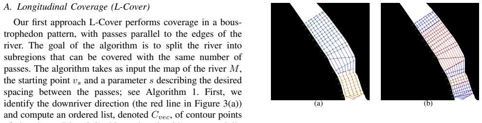
On the paper's own terms, riverine coverage is a geometric partitioning problem. L-Cover divides the river into clusters whose widths are close enough that a constant number of shore-parallel passes, spaced by a parameter s, covers each cluster completely; the number of passes adapts to the width. T-Cover instead lays passes perpendicular to the shores, applying the boustrophedon idea along the river's curvature. Z-Cover chooses each next shore-contact point so that consecutive triangles formed with the previous two path points have nearly equal areas, which spreads samples evenly across the river rather than overshooting one bank. The reported simulation numbers are 92.65% covered area for L-Cover, 91.42% for T-Cover, 31.05% for Z-Cover, and 29.39% for the fixed-angle heuristic; in the field, an L-Cover trajectory covered roughly twice the area of a manual survey in about the same operating time.
Load-bearing premise
The completeness guarantee depends on the sensor footprint being a fixed width computed from the average river depth; if depth, sensor tilt, or turning motion changes the footprint, the planner can leave gaps that its coverage percentages do not predict.
Editorial extensions
If this is right
- L-Cover is the preferred complete-coverage pattern for side-scan sonar surveys because it couples high covered area (92.65% in simulation) with a short return path (8.9%).
- T-Cover reaches similar completeness (91.42%) but with more turns and a longer return trip, so it fits missions where the riverbed must be sampled across the width within a short time window.
- Z-Cover is a partial-coverage method: it samples about a third of the river in one pass, with slightly better and more even coverage than the fixed-angle heuristic while avoiding severe overshoot.
- The choice of planner affects map quality, not just path length: bathymetric maps built from L-Cover data showed lower uncertainty than those from Z- or T-Cover in the field trials.
- More than 35 km of executed trajectories show the planned paths are trackable by GPS waypoint navigation on real water, so the geometric guarantees survive practical deployment.
Reading between the lines
- A natural next step, not taken in the paper, is to replace the constant-footprint assumption with a depth-dependent sonar model and let pass spacing adapt locally; the completeness guarantee would then extend to rivers with strong bathymetric relief.
- The equal-triangle rule in Z-Cover could be made flow-aware by weighting triangle areas with expected current drift, which would likely reduce the overshoot observed in fast-moving reaches.
- The same width-clustering idea transfers to other corridor environments, such as narrow aerial canyons or underwater channels, where ordinary lawn-mower decompositions pay a high penalty in turns.
Signed reviews
Editorial analysis
A structured set of objections, weighed in public.
Referee Report
Summary. The paper addresses autonomous coverage path planning for riverine surveying with an autonomous surface vehicle (ASV). Three deterministic planners are proposed: L-Cover, which runs longitudinal passes parallel to the shores and adapts the number of passes to the river width; Z-Cover, a zigzag partial-coverage strategy intended for single-pass surveys; and T-Cover, a transverse lawn-mowing strategy. The authors claim that L-Cover and T-Cover provide complete coverage for a fixed sensor footprint, and they report simulation results on real river maps as well as field deployments on the Congaree River, stating that the approach improves accuracy and efficiency over manual surveying.
Significance. If the central claims are supported, the work is a useful practical contribution to an application domain where autonomous riverine surveying is still uncommon. The paper gives explicit algorithmic descriptions, compares against a fixed-angle manual surveying baseline, and includes real field deployments with bathymetric and side-scan sonar data, which is commendable. The main significance, however, rests on the completeness guarantee for L-Cover and T-Cover, and on the quantitative superiority over human performance. These claims are not adequately supported by the paper's own data: the reported coverage percentages are well below 100%, the reported field distances do not match the abstract's 35 km figure, and the 'accuracy' improvement lacks quantitative evidence. The practical value of the methods is plausible, but the paper as written does not substantiate its headline claims.
major comments (4)
- [§I and §IV-A, Table I] The completeness claim is in direct tension with the paper's own simulation results. The Introduction states that L-Cover and T-Cover ensure that 'for a fixed sensor footprint no area remains uncovered,' but Table I reports Area Covered of 92.65% for L-Cover and 91.42% for T-Cover. Since §IV-A defines coverage by giving the travel path a width proportional to the spacing parameter s, a gap-free planner should cover close to 100% of the region of interest under the assumed swath model. The authors should either provide a formal proof or a precise set of conditions under which the completeness guarantee holds, or reconcile the metric with the reported percentages. Without this, the paper's strongest theoretical claim is unsupported.
- [Abstract and §IV-B, Table II] The abstract and introduction state that the field deployments produced 'more than 35km of coverage trajectories,' but Table II lists Total Distance values of 5.2 km (Z-Cover), 10 km (T-Cover), and 13.02 km (L-Cover), which sum to 28.22 km. Even the Coverage Distance column sums to only 21.32 km. If additional deployments were performed beyond those listed in Table II, they must be reported; if not, the 35 km figure appears to be an arithmetic inconsistency. This discrepancy undermines confidence in the quantitative reporting and should be fixed.
- [§IV-B and §III-C] The fixed-footprint assumption is load-bearing for the completeness claim but is neither derived nor tested. The paper states that 'the footprint of the bathymetric sensor ... is constant and can be calculated based on the average depth of the area/river.' However, L-Cover and T-Cover generate paths in curved, width-varying rivers: in T-Cover, transverse passes spaced by distance s along one bank or centerline can be separated by more than s near the outer bank of a bend, leaving wedge-shaped uncovered regions, and in L-Cover the cluster-merging step in Algorithm 1 (Lines 13-15) can produce similar gaps. The paper provides no geometric argument ruling out such gaps. At minimum, the authors should state the exact conditions under which the guarantee holds and quantify gap size empirically for the simulated and field environments.
- [§IV-B, Figure 5, and Abstract] The claimed 'increases in accuracy and efficiency compared to human performance' are not quantitatively supported. Table II provides times and distances, but the accuracy comparison is qualitative; Figure 5 shows depth and uncertainty maps, but no numerical RMSE, coverage error, or statistical comparison against manual surveys is reported. The paper should either add quantitative accuracy metrics (e.g., RMSE values from the GP maps, or comparison of bathymetric estimates) or explicitly limit the claim to efficiency and qualitative map quality.
minor comments (4)
- [Algorithm 2] The pseudocode for Z-Cover is ambiguous: the unconditional 'break' after the triangle-area check appears to exit the for loop after the first candidate, making the retry logic in Lines 13-15 unreachable. Please revise the indentation and control flow to match the intended search over d candidate lines.
- [Throughout] There are several typographical errors, including 'a a lawn-mowing pattern' in Section III-C, 'Figure Figure 2' in Section III-A, and 'parameters describing' in Section III-A. A careful proofreading pass is recommended.
- [Table II] The table lists algorithms in the order Z-Cover, T-Cover, L-Cover, while the text in Section IV-B discusses them in a different order. Please align the order for readability.
- [§III-B] The Z-Cover method is described as producing triangles with approximately equal areas, but the relation between equal triangle areas and 'the ratio of the covered areas across the river' is not explained. A short derivation or diagram reference would help the reader understand the geometric motivation.
Circularity Check
No significant circularity: the coverage metric is a geometric evaluation tied to the planner's spacing parameter, but the central comparisons are external or between independently generated patterns, and no self-citation chain is load-bearing.
full rationale
The paper's coverage experiments use the assumption 'For all algorithms we assume that the travel path π has a width proportional to the spacing value s' (Sec. IV-A), and L-Cover/T-Cover indeed generate passes with spacing s. This makes the Covered Area metric a self-referential geometric measure: it reports how well the path maintains its own spacing. However, that is an evaluation convention, not a prediction derived from the algorithms, and Table I reports 92.65% and 91.42% rather than 100%, so the metric does not simply return the input parameter. The central comparisons are external: Z-Cover is benchmarked against a fixed-angle manual-survey heuristic, and L-Cover versus T-Cover is a within-paper comparison of two different patterns. The paper's completeness claim ('ensuring that for a fixed sensor footprint no area remains uncovered') is asserted without proof and is in tension with the reported coverage percentages, but this is an unproven guarantee or correctness risk, not a circular reduction: the claim does not follow from the equations by construction, and it is not justified by a self-citation. Citations to the authors' prior work ([4], [23], [25], [26]) support hardware, current modeling, and multi-robot extensions; none is load-bearing for the coverage algorithms' correctness. No fitted parameter is renamed as a prediction, and no uniqueness theorem is imported. The derivation chain is therefore self-contained, with the caveat that the completeness guarantee is not established.
Assumptions & free parameters
free parameters (5)
- Spacing parameter s
- Contour step size Δw
- Angle increment α
- Number of candidate lines d
- Area tolerance Δϵ
assumptions (4)
- domain assumption A known occupancy grid map of the river is available and accurate.
- domain assumption The sensor footprint is constant and equal to the spacing parameter s.
- domain assumption The ASV can follow waypoint paths well enough that planned paths approximate executed paths.
- ad hoc to paper The river width does not change significantly between contour samples within one cluster.
Cite this review
Pith. "Pith review of Riverine Coverage with an Autonomous Surface Vehicle over Known Environments." pith.science (2026). https://pith.science/paper/YCTMAWPB
@misc{pith2026190802827,
  author       = {Pith},
  title        = {Pith review of: Riverine Coverage with an Autonomous Surface Vehicle over Known Environments},
  year         = {2026},
  howpublished = {\url{https://pith.science/paper/YCTMAWPB}},
  note         = {Machine review of arXiv:1908.02827}
}
read the original abstract
Environmental monitoring and surveying operations on rivers currently are performed primarily with manually-operated boats. In this domain, autonomous coverage of areas is of vital importance, for improving both the quality and the efficiency of coverage. This paper leverages human expertise in river exploration and data collection strategies to automate and optimize these processes using autonomous surface vehicles(ASVs). In particular, three deterministic algorithms for both partial and complete coverage of a river segment are proposed,providing varying path length, coverage density, and turning patterns. These strategies resulted in increases in accuracy and efficiency compared to human performance.The proposed methods were extensively tested in simulation using maps of real rivers of different shapes and sizes. In addition, to verify their performance in real world operations, the algorithms were deployed successfully on several parts of the Congaree River in South Carolina, USA, resulting in total of more than 35km of coverage trajectories in the field.
Figures


Figures from the paper (5 more)


Reference graph
Works this paper leans on
-
[1]
Morse Decompositions for Coverage Tasks,
E. U. Acar, H. Choset, A. A. Rizzi, P. N. Atkar, and D. Hull, “Morse Decompositions for Coverage Tasks,” Int. J. Robot. Res. , 2002
work page 2002
-
[2]
Sensor-based Coverage of Unknown Environments: Incremental Construction of Morse Decompositions,
E. U. Acar and H. Choset, “Sensor-based Coverage of Unknown Environments: Incremental Construction of Morse Decompositions,” Int. J. Robot. Res. , 2002
work page 2002
-
[3]
Heraclitus of Ephesus, As quoted by Plato in Cratylus . 402a, 535 BC – 475 BC. (a) (b) (c) (d) (e) (f) Fig. 5. The depth map (in meters) of covered region and uncertainty map of selected method for that region expressed by RMSE (a), (d) L-Cover, (b),(e) Z-Cover, (c),(f) T-Cover (a) (b) (c) (d) (e) (f) (g) (h) Fig. 6. Riverine Coverage on Congaree River, S...
-
[4]
An autonomous surface vehicle for long term operations,
J. Moulton, N. Karapetyan, S. Bukhsbaum, C. McKinney, S. Malebary, G. Sophocleous, A. Q. Li, and I. Rekleitis, “An autonomous surface vehicle for long term operations,” in MTS/IEEE OCEANS , 2018
work page 2018
-
[5]
Autonomous bathymetry for risk assessment with ROAZ robotic surface vehicle,
H. Ferreira, C. Almeida, A. Martins, J. Almeida, N. Dias, A. Dias, and E. Silva, “Autonomous bathymetry for risk assessment with ROAZ robotic surface vehicle,” in MTS/IEEE Oceans-Europe, 2009
work page 2009
-
[6]
F. D. Snyder, D. D. Morris, P. H. Haley, R. T. Collins, and A. M. Okerholm, “Autonomous river navigation,” in Mobile robots XVII . International Society for Optics and Photonics, 2004
work page 2004
-
[7]
S. Jain, S. Nuske, A. Chambers, L. Yoder, H. Cover, L. Chamberlain, S. Scherer, and S. Singh, “Autonomous river exploration,” inField and Service Robotics . Springer, 2015
work page 2015
-
[8]
Y . Zhang, J. G. Bellingham, J. P. Ryan, B. Kieft, and M. J. Stanway, “Two-dimensional mapping and tracking of a coastal upwelling front by an autonomous underwater vehicle,” in MTS/IEEE Oceans , 2013
work page 2013
Show all 26 references
-
[9]
Robots going round the benda comparative study of estimators for anticipating river meanders,
K. Qin and D. A. Shell, “Robots going round the benda comparative study of estimators for anticipating river meanders,” in Proc. ICRA , 2017. (a) (b) (c) (d) Fig. 7. Backscatter image of riverbed, Congaree River. Top row shows the bathymetric map compiled from the Ping DSP dat...
2017
-
[10]
A survey on coverage path planning for robotics,
E. Galceran and M. Carreras, “A survey on coverage path planning for robotics,” Robotics and Autonomous systems , 2013
2013
-
[11]
Deployment of drifters in a piecewise- constant flow environment,
A. Kwok and S. Mart ´ınez, “Deployment of drifters in a piecewise- constant flow environment,” in Proc. CDC, 2010
2010
-
[12]
A coverage algorithm for drifters in a river environment,
——, “A coverage algorithm for drifters in a river environment,” in Proc. ACC, 2010
2010
-
[13]
Energy constrained multi-robot sensor-based coverage path planning using capacitated arc routing approach,
A. Sipahioglu, G. Kirlik, O. Parlaktuna, and A. Yazici, “Energy constrained multi-robot sensor-based coverage path planning using capacitated arc routing approach,” RAS, 2010
2010
-
[14]
Efficient terrain driven coral coverage using Gaussian Processes for mosaic synthesis,
S. Manjanna, N. Kakodkar, M. Meghjani, and G. Dudek, “Efficient terrain driven coral coverage using Gaussian Processes for mosaic synthesis,” in Computer and Robot Vision (CRV) , 2016
2016
-
[15]
Semi- boustrophedon coverage with a dubins vehicle,
J. Lewis, W. Edwards, K. Benson, I. Rekleitis, and J. O’Kane, “Semi- boustrophedon coverage with a dubins vehicle,” in Proc. IROS, 2017
2017
-
[16]
Sampling-based Motion Plan- ning for Robotic Information Gathering,
G. A. Hollinger and G. S. Sukhatme, “Sampling-based Motion Plan- ning for Robotic Information Gathering,” in RSS, 2013
2013
-
[17]
Efficient informative sensing using multiple robots,
A. Singh, A. Krause, C. Guestrin, and W. J. Kaiser, “Efficient informative sensing using multiple robots,” JAIR, 2009
2009
-
[18]
Heterogeneous Multirobot System for Exploration and Strategic Water Sampling,
S. Manjanna, A. Quattrini Li, R. N. Smith, I. Rekleitis, and G. Dudek, “Heterogeneous Multirobot System for Exploration and Strategic Water Sampling,” in Proc. ICRA, 2018
2018
-
[19]
Massively multi-robot simulation in stage,
R. Vaughan, “Massively multi-robot simulation in stage,” Swarm intelligence, 2008
2008
-
[20]
ROS: an open-source Robot Operating System,
M. Quigley, K. Conley, B. P. Gerkey, J. Faust, T. Foote, J. Leibs, R. Wheeler, and A. Y . Ng, “ROS: an open-source Robot Operating System,” in ICRA Workshop on Open Source Software , 2009
2009
-
[21]
Efficient complete coverage of a known arbitrary environment with applications to aerial opera- tions,
A. Xu, C. Viriyasuthee, and I. Rekleitis, “Efficient complete coverage of a known arbitrary environment with applications to aerial opera- tions,” Auton. Robot. , 2014
2014
-
[22]
Rasmussen and C
C. Rasmussen and C. Williams, Gaussian Processes for Machine Learning. MIT Press, 2006
2006
-
[23]
External force field modeling for autonomous surface vehicles,
J. Moulton, N. Karapetyan, A. Q. Li, and I. Rekleitis, “External force field modeling for autonomous surface vehicles,” arXiv preprint arXiv:1809.02958, 2018
2018 arXiv
-
[24]
Ping DSP Inc
“Ping DSP Inc.” http://www.pingdsp.com/3DSS-DX-450, [Accessed: 2018-05-11]
2018
-
[25]
Efficient multi-robot coverage of a known environment,
N. Karapetyan, K. Benson, C. McKinney, P. Taslakian, and I. Rekleitis, “Efficient multi-robot coverage of a known environment,” in Proc. IROS, 2017
2017
-
[26]
Multi-robot dubins coverage with autonomous surface vehicles,
N. Karapetyan, J. Moulton, J. S. Lewis, A. Quattrini Li, J. M. O’Kane, and I. M. Rekleitis, “Multi-robot dubins coverage with autonomous surface vehicles,” in Proc. ICRA, 2018
2018
Reviewed August 14, 2026 · model on record in the stance chip above.
Discussion (0). Continue with ORCID to comment.