REVIEW 3 major objections 6 minor 123 references
UAVScenes: A Multi-Modal Dataset for UAVs
T0 review · 3 major / 6 minor · reviewed 2026-08-06 · deepseek-v4-flash
Pith's one-line read UAVScenes provides the first UAV dataset with frame-wise semantic labels for both camera images and LiDAR point clouds together with 6-DoF poses, spanning over 120,000 frames across towns, valleys, airports, and islands.
desk verdict Useful multi-modal UAV dataset that currently lacks the one quantitative validation—pose accuracy—that its core claims depend on. read the letter →
The pith
A machine-rendered reading of the paper's core claim, the machinery that carries it, and where it could break.
The reading
What carries the argument
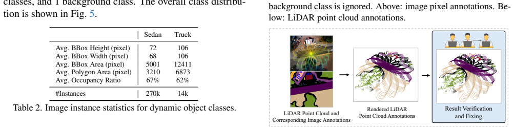
The central mechanism is the annotation pipeline that turns raw SLAM data into multi-modal ground truth. Its key steps are: (1) DJI Terra SfM reconstructs one 3D map per split of one to three same-day sequences, yielding 6-DoF poses and geometry while accepting GNSS coordinates as initialization; (2) annotators label 16 static classes directly on the 3D maps, which are then rendered onto camera views to produce temporally consistent 2D semantic masks; (3) two dynamic classes (sedan, truck) are labeled instance-wise in 2D and fused with the rendered masks; (4) using the hardware-calibrated camera-LiDAR extrinsics, the image labels are projected into each Livox-Avia LiDAR frame to produce frame-wise 3D annotations. This pipeline is what makes the resulting 120k annotated frame pairs and eight reconstructed maps usable across six perception tasks.
What would settle it
Take one of the eight splits and compute a reference trajectory with post-processed RTK-GNSS/INS; if the per-frame position error of the Terra poses is on the order of several meters, the 6-DoF localization and NVS benchmarks would no longer be measuring what they claim.
Extended reading notes
Core claim
UAVScenes starts from the MARS-LVIG SLAM dataset, which provides hardware-synchronized camera and Livox-Avia LiDAR data but only 4-DoF RTK poses and no semantics. The paper's central discovery is the construction of a dataset that simultaneously provides 6-DoF poses, reconstructed 3D maps, and frame-wise semantic labels for both images and LiDAR point clouds—a combination no existing UAV dataset offers. The authors achieve this by splitting the sequences into eight consistent groups, reconstructing each group with DJI Terra structure-from-motion to get 6-DoF poses and geometry, manually labeling 16 static scene classes on the reconstructed 3D maps, rendering those labels onto camera frames to get image masks, adding manual instance labels for sedans and trucks, and projecting the image labels onto the LiDAR point clouds using the sensor calibration. They then benchmark six perception tasks with state-of-the-art methods, establishing baseline results on the new dataset.
Load-bearing premise
The DJI Terra 6-DoF poses are treated as ground truth without being checked against an independent, quantitative pose reference.
Editorial extensions
If this is right
- Image and LiDAR semantic segmentation can be benchmarked on the same real UAV scenes, with baseline results indicating Transformer-based image models (DeiT3) outperform ConvNets and the 'pool' class is a hard case for LiDAR segmentation.
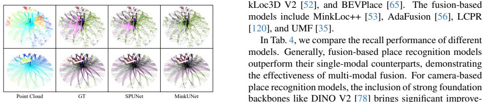
- Fusion-based place recognition methods outperformed camera-only and LiDAR-only baselines on this dataset, supporting the value of multi-modal fusion for aerial place retrieval.
- Zero-shot monocular depth models perform poorly on UAV perspectives (best AbsRel 0.472), pointing to a clear gap for future depth estimation methods.
- 3D Gaussian Splatting methods (3DGS, Pixel-GS) clearly outperform the NeRF-based Instant-NGP on large-scale aerial scenes, giving a baseline for NVS research in this setting.
- The dataset provides over 120k frames with multiple traversals across diverse environments, enabling robustness studies across lighting and speed variations.
Reading between the lines
- Because the Terra-derived 6-DoF poses were validated only by qualitative image-overlay alignment, the localization and NVS numbers in the paper should be treated as method-comparison results rather than absolute pose-accuracy measurements.
- The benchmark uses only the Livox-Avia LiDAR; excluding the encrypted DJI-L1 point clouds ties all 3D tasks to a single sensor's scan pattern, so the LiDAR segmentation and place-recognition results may not transfer to other LiDAR hardware.
- The dataset's evening sequences and repeated traversals could support long-term place recognition and illumination-robustness studies, which the paper lists as data features but does not benchmark explicitly.
- The pipeline of labeling 3D maps and rendering labels into frames could be adapted to add semantic annotations to other raw SLAM datasets at lower manual cost, a transfer the paper does not claim.
Editorial analysis
A structured set of objections, weighed in public.
Referee Report
Summary. UAVScenes is a multi-modal dataset paper built on the MARS-LVIG platform. It contributes 120k frame-wise semantic annotations for Hikvision images and Livox-Avia LiDAR point clouds (19 classes), 6-DoF poses and 3D maps reconstructed with DJI Terra, and benchmark evaluations of six perception tasks: image and LiDAR semantic segmentation, place recognition, novel view synthesis, 6-DoF visual localization, and depth estimation. The authors argue that no existing UAV dataset simultaneously provides 6-DoF poses and frame-wise annotations for both camera and LiDAR on real scenes, and they release code and train/test splits. The central quantitative claims are the accuracy of the Terra poses and the quality of the rendered/projected semantic labels.
Significance. The resource, if validated, would be a valuable addition to the UAV perception ecosystem. Its strengths are substantial: 120k annotated real frames, multiple environments with repeated traversals, open release of annotations and baseline code, and a broad set of benchmark tasks using recent state-of-the-art methods. The paper is careful in documenting reconstruction choices and recognizes limitations (e.g., the sparse pool class in the LiDAR segmentation benchmark). I do not see a derivational circularity in the benchmark methodology. The main risk is the unvalidated single-chain use of DJI Terra: the dataset's unique selling point is precisely the joint availability of pose, image labels, and LiDAR labels, and all three are generated from the same reconstruction. A quantitative pose check against MARS-LVIG's RTK data or an independent SfM/LiDAR-SLAM trajectory would materially raise confidence in every downstream number.
major comments (3)
- [Section 3.1, Figures 2 and 3] The paper's central 'accurate 6-DoF poses' claim is supported only by rendered-versus-real overlays. No pose-error statistics against an independent reference are reported, yet the Terra poses are used as ground truth for the localization benchmark in Section 4.5, as supervision for NVS in Section 4.4, as the geometry for rendering all static semantic masks in Section 3.2.1, and as the projection chain for obtaining LiDAR labels in Section 3.3. Any systematic bias in the Terra reconstruction therefore propagates into the semantic labels, LiDAR labels, localization numbers, and NVS numbers. This is more serious than the absence of inter-annotator agreement, because even perfect manual verification cannot fix masks whose underlying pose and 3D geometry are biased. Please add a quantitative validation: compare the Terra translational trajectory against the RTK/GNSS positions already available in MARS-LVIG, report per-split drift or loop-closure consistency on repeated traversals, or compare Terra poses with a LiDAR-inertial SLAM estimate on segments where it succeeds. Until such numbers are provided, the dataset's headline claim should be treated as conditional.
- [Sections 3.2.1, 3.2.2, and 3.3] Annotation quality assurance is described only as 'manual check' and 'thorough consistency checks,' with no inter-annotator agreement, no number of corrected frames, and no independent verification of the 3D map labels. Since the 2D masks are rendered from the Terra-reconstructed 3D map and the LiDAR masks are obtained by projecting those 2D masks through the same pose and calibration chain, the reported label quality is inseparable from the unvalidated reconstruction. Please report a measurable quality protocol, such as Intersection-over-Union between rendered masks and a manually annotated held-out subset, or inter-annotator agreement statistics, and state how dynamic objects are excluded from the static rendering step.
- [Section 4.6, Table 7, and Eq. (S7)] The reported δ1 value for Depth Anything V2 (ViT-b) is 1.670, but Eq. (S7) defines δ1 as an average of indicator functions and hence it cannot exceed 1. This indicates either a unit error (values expressed as percentages while other rows are fractions) or a bug in the evaluation code, and it undermines the depth-estimation benchmark as a quantitative comparison. Please recompute the table, state the units for δ1 explicitly, and specify how invalid pixels (e.g., points beyond LiDAR range or on dynamic objects) are masked before computing AbsRel, SqRel, and δ1.
minor comments (6)
- [Throughout] Spacing artifacts such as 'UA Vs', 'UA VScenes', and 'MARS-LVIG'/'Mars-LVIG' appear in the title, abstract, and body; please standardize these names.
- [Section 2.1 and Table 1] The dataset is named MUM-FRL in the text but MUN-FRL in Table 1 and in reference [88]; please use one consistent name.
- [Section 4.6] The in-text citations for depth models are inconsistent: the text says 'Depth Anything [9]' but reference [9] is ZoeDepth, while [109] and [110] are the Depth Anything papers; please correct all citation keys.
- [Supplementary S6.2] The GNSS interpolation step is described only briefly; please document the interpolation method, the coordinate-frame conventions, and whether the interpolated GNSS is used as hard constraints or only as initialization in Terra, since this affects the interpretation of any pose validation.
- [Tables 3 and 7] Please state explicitly whether mIoU and δ1 values are fractions or percentages; the δ1 column in Table 7 currently mixes conventions (e.g., 0, 0.010, and 1.670).
- [Section 1 and dataset URL] The paper should state the license and terms of use for the derived dataset relative to MARS-LVIG, especially because the base dataset is contributed by overlapping authors and the reconstruction uses the closed-source DJI Terra.
Circularity Check
No derivational circularity: the new annotations and benchmark numbers are measurements built from external sensor data and independent baselines; the missing Terra pose validation is a correctness risk, not a circular step.
full rationale
UAVScenes does not derive any of its headline quantities from the quantities it claims to predict. The 6-DoF poses are produced by DJI Terra SfM from MARS-LVIG imagery and GNSS coordinates (Section 3.1); the frame-wise semantic masks are produced by manual annotation of the reconstructed 3D maps, rendering onto camera views, and manual correction (Sections 3.2.1-3.2.2); LiDAR labels are produced by projecting image annotations using the hardware calibration (Section 3.3). The benchmark numbers in Tables 3-7 are evaluations of independent open-source models against these labels and poses, not fitted parameters renamed as predictions. The authors' own RobustLoc and the MARS-LVIG base dataset involve author overlap, but neither is used to justify the target claim by definition: MARS-LVIG supplies raw sensor data and calibration from prior work, while RobustLoc is one of many baselines whose inclusion does not force any benchmark outcome. The absence of an independent quantitative check of the DJI Terra poses, with only qualitative overlays in Figures 2 and 3, is a genuine correctness and robustness concern, but it is not circularity: no equation or construction makes the pose error vanish by definition. The dataset is self-contained as a new measurement artifact, so the circularity score is 0.
Assumptions & free parameters
assumptions (3)
- domain assumption MARS-LVIG camera-LiDAR calibration and hardware synchronization are correct.
- domain assumption The DJI Terra SfM reconstructions provide accurate 6-DoF poses.
- domain assumption Manual annotations and X-AnyLabeling tracking with human verification yield correct semantic labels.
Cite this review
Pith. "Pith review of UAVScenes: A Multi-Modal Dataset for UAVs." pith.science (2026). https://pith.science/paper/YXQJY3YF
@misc{pith2026250722412,
  author       = {Pith},
  title        = {Pith review of: UAVScenes: A Multi-Modal Dataset for UAVs},
  year         = {2026},
  howpublished = {\url{https://pith.science/paper/YXQJY3YF}},
  note         = {Machine review of arXiv:2507.22412}
}
read the original abstract
Multi-modal perception is essential for unmanned aerial vehicle (UAV) operations, as it enables a comprehensive understanding of the UAVs' surrounding environment. However, most existing multi-modal UAV datasets are primarily biased toward localization and 3D reconstruction tasks, or only support map-level semantic segmentation due to the lack of frame-wise annotations for both camera images and LiDAR point clouds. This limitation prevents them from being used for high-level scene understanding tasks. To address this gap and advance multi-modal UAV perception, we introduce UAVScenes, a large-scale dataset designed to benchmark various tasks across both 2D and 3D modalities. Our benchmark dataset is built upon the well-calibrated multi-modal UAV dataset MARS-LVIG, originally developed only for simultaneous localization and mapping (SLAM). We enhance this dataset by providing manually labeled semantic annotations for both frame-wise images and LiDAR point clouds, along with accurate 6-degree-of-freedom (6-DoF) poses. These additions enable a wide range of UAV perception tasks, including segmentation, depth estimation, 6-DoF localization, place recognition, and novel view synthesis (NVS). Our dataset is available at https://github.com/sijieaaa/UAVScenes
Figures


Figures from the paper (7 more)





Reference graph
Works this paper leans on
-
[1]
https : / / github
Semantic drone dataset. https : / / github . com / ayushdabra / drone - images - semantic - segmentation. 2, 3
-
[2]
3d map- ping with a drone equipped with a depth camera in indoor environment
Stanislav Alexovi ˇc, Milan Lacko, and J ´an Baˇc´ık. 3d map- ping with a drone equipped with a depth camera in indoor environment. Acta Electrotechnica et Informatica , 23(1): 18–24, 2023. 2
2023
-
[3]
MixVPR: Feature mixing for visual place recognition
Amar Ali-Bey, Brahim Chaib-Draa, and Philippe Giguere. MixVPR: Feature mixing for visual place recognition. In Proceedings of the IEEE/CVF Winter Conference on Appli- cations of Computer Vision, pages 2998–3007, 2023. 6, 7, 15
2023
-
[4]
GSV-Cities: Toward appropriate supervised visual place recognition
Amar Alibey, Brahim Chaibdraa, and Philippe Giguere. GSV-Cities: Toward appropriate supervised visual place recognition. Neurocomputing, 513:194–203, 2022. 6, 7
2022
-
[5]
NetVLAD: CNN architecture for weakly supervised place recognition
Relja Arandjelovic, Petr Gronat, Akihiko Torii, Tomas Pa- jdla, and Josef Sivic. NetVLAD: CNN architecture for weakly supervised place recognition. In Proceedings of the IEEE/CVF Conference on Computer Vision and Pattern Recognition, pages 5297–5307, 2016. 6
2016
-
[6]
Joint 2d-3d-semantic data for indoor scene understanding
Iro Armeni, Sasha Sax, Amir R Zamir, and Silvio Savarese. Joint 2d-3d-semantic data for indoor scene understanding. arXiv preprint arXiv:1702.01105, 2017. 4
arXiv 2017
-
[7]
Se- mantickitti: A dataset for semantic scene understanding of lidar sequences
Jens Behley, Martin Garbade, Andres Milioto, Jan Quen- zel, Sven Behnke, Cyrill Stachniss, and Jurgen Gall. Se- mantickitti: A dataset for semantic scene understanding of lidar sequences. In Proceedings of the IEEE/CVF inter- national conference on computer vision, pages 9297–9307,
-
[8]
Uav-based delivery systems: a systematic review, current trends, and research challenges
Francesco Betti Sorbelli. Uav-based delivery systems: a systematic review, current trends, and research challenges. Journal on Autonomous Transportation Systems, 1(3):1–40,
Show all 123 references
-
[9]
Zoedepth: Zero-shot trans- fer by combining relative and metric depth
Shariq Farooq Bhat, Reiner Birkl, Diana Wofk, Peter Wonka, and Matthias M ¨uller. Zoedepth: Zero-shot trans- fer by combining relative and metric depth. arXiv preprint arXiv:2302.12288, 2023. 8, 16
2023 arXiv
-
[10]
Accelerated coordinate encoding: Learning to relocalize in minutes using rgb and poses
Eric Brachmann, Tommaso Cavallari, and Victor Adrian Prisacariu. Accelerated coordinate encoding: Learning to relocalize in minutes using rgb and poses. In CVPR, 2023. 7, 8, 16
2023
-
[11]
The euroc micro aerial vehicle datasets
Michael Burri, Janosch Nikolic, Pascal Gohl, Thomas Schneider, Joern Rehder, Sammy Omari, Markus W Achte- lik, and Roland Siegwart. The euroc micro aerial vehicle datasets. The International Journal of Robotics Research , 35(10):1157–1163, 2016. 2
2016
-
[12]
nuScenes: A mul- timodal dataset for autonomous driving
Holger Caesar, Varun Bankiti, Alex H Lang, Sourabh V ora, Venice Erin Liong, Qiang Xu, Anush Krishnan, Yu Pan, Giancarlo Baldan, and Oscar Beijbom. nuScenes: A mul- timodal dataset for autonomous driving. In Proceedings of the IEEE/CVF conference on Computer Vision and Pattern...
2020
-
[13]
BEV-LIO(LC): Bev image assisted lidar- inertial odometry with loop closure
Haoxin Cai, Shenghai Yuan, Xinyi Li, Junfeng Guo, and Jianqi Liu. BEV-LIO(LC): Bev image assisted lidar- inertial odometry with loop closure. In Proceedings of the IEEE/RSJ International Conference on Intelligent Robots and Systems (IROS). IEEE, 2025. 3
2025
-
[14]
Vdd: Varied drone dataset for semantic segmentation
Wenxiao Cai, Ke Jin, Jinyan Hou, Cong Guo, Letian Wu, and Wankou Yang. Vdd: Varied drone dataset for semantic segmentation. arXiv preprint arXiv:2305.13608, 2023. 2, 3
2023 arXiv
-
[15]
Direct: A differential dynamic programming based frame- work for trajectory generation
Kun Cao, Muqing Cao, Shenghai Yuan, and Lihua Xie. Direct: A differential dynamic programming based frame- work for trajectory generation. IEEE Robotics and Automa- tion Letters, 7(2):2439–2446, 2022. 1
2022
-
[16]
Online trajectory correction and tracking for facade inspec- tion using autonomous uav
Muqing Cao, Yang Lyu, Shenghai Yuan, and Lihua Xie. Online trajectory correction and tracking for facade inspec- tion using autonomous uav. In 2020 IEEE 16th Interna- tional Conference on Control & Automation (ICCA), pages 1149–1154. IEEE, 2020. 1
2020
-
[17]
Path planning for multiple tethered robots using topological braids
Muqing Cao, Kun Cao, Shenghai Yuan, Kangcheng Liu, Yan Loi Wong, and Lihua Xie. Path planning for multiple tethered robots using topological braids. In Proceedings of Robotics: Science and Systems, 2023. 1
2023
-
[18]
Neptune: nonentangling trajectory planning for multiple tethered unmanned vehicles
Muqing Cao, Kun Cao, Shenghai Yuan, Thien-Minh Nguyen, and Lihua Xie. Neptune: nonentangling trajectory planning for multiple tethered unmanned vehicles. IEEE Transactions on Robotics, 39(4):2786–2804, 2023. 1
2023
-
[19]
Stpls3d: A large-scale synthetic and real aerial photogrammetry 3d point cloud dataset
Meida Chen, Qingyong Hu, Zifan Yu, Hugues Thomas, An- drew Feng, Yu Hou, Kyle McCullough, Fengbo Ren, and Lucio Soibelman. Stpls3d: A large-scale synthetic and real aerial photogrammetry 3d point cloud dataset. arXiv preprint arXiv:2203.09065, 2022. 3
2022
-
[20]
Gaus- sianpro: 3d gaussian splatting with progressive propaga- tion
Kai Cheng, Xiaoxiao Long, Kaizhi Yang, Yao Yao, Wei Yin, Yuexin Ma, Wenping Wang, and Xuejin Chen. Gaus- sianpro: 3d gaussian splatting with progressive propaga- tion. In ICML, 2024. 6, 8, 16
2024
-
[21]
4d spatio-temporal convnets: Minkowski convolutional neural networks
Christopher Choy, JunYoung Gwak, and Silvio Savarese. 4d spatio-temporal convnets: Minkowski convolutional neural networks. In Proceedings of the IEEE Conference on Computer Vision and Pattern Recognition, pages 3075– 3084, 2019. 6, 7
2019
-
[22]
Alto: A large-scale dataset for uav visual place recognition and localization
Ivan Cisneros, Peng Yin, Ji Zhang, Howie Choset, and Sebastian Scherer. Alto: A large-scale dataset for uav visual place recognition and localization. arXiv preprint arXiv:2207.12317, 2022. 2, 3
2022 arXiv
-
[23]
SpConv: Spatially sparse convolu- tion library
SpConv Contributors. SpConv: Spatially sparse convolu- tion library. https://github.com/traveller59/ spconv, 2022. 6, 7
2022
-
[24]
Scannet: Richly-annotated 3d reconstructions of indoor scenes
Angela Dai, Angel X Chang, Manolis Savva, Maciej Hal- ber, Thomas Funkhouser, and Matthias Nießner. Scannet: Richly-annotated 3d reconstructions of indoor scenes. In Proceedings of the IEEE conference on computer vision and pattern recognition, pages 5828–5839, 2017. 4
2017
-
[25]
Compact 3d gaussian splatting for dense visual slam
Tianchen Deng, Yaohui Chen, Leyan Zhang, Jianfei Yang, Shenghai Yuan, Jiuming Liu, Danwei Wang, Hesheng Wang, and Weidong Chen. Compact 3d gaussian splatting for dense visual slam. arXiv preprint arXiv:2403.11247 ,
-
[26]
Incremental joint learning of depth, pose and implicit scene representation on monocular camera in large-scale scenes
Tianchen Deng, Nailin Wang, Chongdi Wang, Shenghai Yuan, Jingchuan Wang, Danwei Wang, and Weidong Chen. Incremental joint learning of depth, pose and implicit scene representation on monocular camera in large-scale scenes. arXiv preprint arXiv:2404.06050, 2024. 2
2024
-
[27]
Firestereo: Forest infrared stereo dataset for uas depth perception in visually degraded environments
Devansh Dhrafani, Yifei Liu, Andrew Jong, Ukcheol Shin, Yao He, Tyler Harp, Yaoyu Hu, Jean Oh, and Sebastian Scherer. Firestereo: Forest infrared stereo dataset for uas depth perception in visually degraded environments. arXiv preprint arXiv:2409.07715, 2024. 2, 3, 4
2024 arXiv
-
[28]
An image is worth 16x16 words: Transformers for image recognition at scale
Alexey Dosovitskiy. An image is worth 16x16 words: Transformers for image recognition at scale. arXiv preprint arXiv:2010.11929, 2020. 6, 7
2010 arXiv
-
[29]
CARLA: An open urban driving simulator
Alexey Dosovitskiy, German Ros, Felipe Codevilla, Anto- nio Lopez, and Vladlen Koltun. CARLA: An open urban driving simulator. In Proceedings of the 1st Annual Confer- ence on Robot Learning, pages 1–16, 2017. 2
2017
-
[30]
The unmanned aerial vehicle benchmark: Ob- ject detection and tracking
Dawei Du, Yuankai Qi, Hongyang Yu, Yifan Yang, Kai- wen Duan, Guorong Li, Weigang Zhang, Qingming Huang, and Qi Tian. The unmanned aerial vehicle benchmark: Ob- ject detection and tracking. In Proceedings of the Euro- pean conference on computer vision (ECCV) , pages 370– 386,...
2018
-
[31]
Develop- ment control and navigation of octocopter
Meng Joo Er, Shenghai Yuan, and Ning Wang. Develop- ment control and navigation of octocopter. In 2013 10th IEEE International Conference on Control and Automation (ICCA), pages 1639–1643. IEEE, 2013. 2
2013
-
[32]
Hazydet: Open-source bench- mark for drone-view object detection with depth-cues in hazy scenes
Changfeng Feng, Zhenyuan Chen, Renke Kou, Guangwei Gao, Chunping Wang, Xiang Li, Xiangbo Shu, Yimian Dai, Qiang Fu, and Jian Yang. Hazydet: Open-source bench- mark for drone-view object detection with depth-cues in hazy scenes. arXiv preprint arXiv:2409.19833 , 2024. 2, 3
2024 arXiv
-
[33]
Mid-air: A multi-modal dataset for extremely low altitude drone flights
Michael Fonder and Marc Van Droogenbroeck. Mid-air: A multi-modal dataset for extremely low altitude drone flights. In Proceedings of the IEEE/CVF conference on computer vision and pattern recognition workshops, pages 0–0, 2019. 2, 3
2019
-
[34]
Ge- owizard: Unleashing the diffusion priors for 3d geometry estimation from a single image
Xiao Fu, Wei Yin, Mu Hu, Kaixuan Wang, Yuexin Ma, Ping Tan, Shaojie Shen, Dahua Lin, and Xiaoxiao Long. Ge- owizard: Unleashing the diffusion priors for 3d geometry estimation from a single image. In European Conference on Computer Vision, pages 241–258. Springer, 2025. 8, 16
2025
-
[35]
Unifying lo- cal and global multimodal features for place recognition in aliased and low-texture environments
Alberto Garc ´ıa-Hern´andez, Riccardo Giubilato, Klaus H Strobl, Javier Civera, and Rudolph Triebel. Unifying lo- cal and global multimodal features for place recognition in aliased and low-texture environments. arXiv preprint arXiv:2403.13395, 2024. 6, 7, 16
2024 arXiv
-
[36]
Vision meets robotics: The KITTI dataset
Andreas Geiger, Philip Lenz, Christoph Stiller, and Raquel Urtasun. Vision meets robotics: The KITTI dataset. The International Journal of Robotics Research , 32(11):1231– 1237, 2013. 3
2013
-
[37]
Cl ´ement Godard, Oisin Mac Aodha, Michael Firman, and Gabriel J. Brostow. Digging into self-supervised monocular depth prediction. 2019. 8, 16
2019
-
[38]
Deep residual learning for image recognition
Kaiming He, Xiangyu Zhang, Shaoqing Ren, and Jian Sun. Deep residual learning for image recognition. In Proceed- ings of the IEEE/CVF Conference on Computer Vision and Pattern Recognition, pages 770–778, 2016. 6, 7
2016
-
[39]
Drone-based object counting by spatially regularized re- gional proposal network
Meng-Ru Hsieh, Yen-Liang Lin, and Winston H Hsu. Drone-based object counting by spatially regularized re- gional proposal network. In Proceedings of the IEEE inter- national conference on computer vision, pages 4145–4153,
-
[40]
Metric3d v2: A versatile monocular geomet- ric foundation model for zero-shot metric depth and surface normal estimation
Mu Hu, Wei Yin, Chi Zhang, Zhipeng Cai, Xiaoxiao Long, Hao Chen, Kaixuan Wang, Gang Yu, Chunhua Shen, and Shaojie Shen. Metric3d v2: A versatile monocular geomet- ric foundation model for zero-shot metric depth and surface normal estimation. arXiv preprint arXiv:2404.15506, 2024. 8
2024 arXiv
-
[41]
Optimal transport ag- gregation for visual place recognition
Sergio Izquierdo and Javier Civera. Optimal transport ag- gregation for visual place recognition. In Proceedings of the IEEE/CVF Conference on Computer Vision and Pattern Recognition, pages 17658–17668, 2024. 6, 7, 15
2024
-
[42]
Rellis-3d dataset: Data, benchmarks and analy- sis
Peng Jiang, Philip Osteen, Maggie Wigness, and Srikanth Saripalli. Rellis-3d dataset: Data, benchmarks and analy- sis. In 2021 IEEE international conference on robotics and automation (ICRA), pages 1110–1116. IEEE, 2021. 4
2021
-
[43]
Go: The great outdoors multimodal dataset
Peng Jiang, Kasi Viswanath, Akhil Nagariya, George Chustz, Maggie Wigness, Philip Osteen, Timothy Over- bye, Christian Ellis, Long Quang, and Srikanth Saripalli. Go: The great outdoors multimodal dataset. arXiv preprint arXiv:2501.19274, 2025. 4
2025 arXiv
-
[44]
6g non-terrestrial networks enabled low-altitude economy: Opportunities and challenges
Yihang Jiang, Xiaoyang Li, Guangxu Zhu, Hang Li, Jing Deng, Kaifeng Han, Chao Shen, Qingjiang Shi, and Rui Zhang. 6g non-terrestrial networks enabled low-altitude economy: Opportunities and challenges. arXiv preprint arXiv:2311.09047, 2023. 1
2023 arXiv
-
[45]
Re- purposing diffusion-based image generators for monocular depth estimation
Bingxin Ke, Anton Obukhov, Shengyu Huang, Nando Met- zger, Rodrigo Caye Daudt, and Konrad Schindler. Re- purposing diffusion-based image generators for monocular depth estimation. In Proceedings of the IEEE/CVF Confer- ence on Computer Vision and Pattern Recognition , pages 94...
2024
-
[46]
Anyloc: Towards universal vi- sual place recognition
Nikhil Keetha, Avneesh Mishra, Jay Karhade, Kr- ishna Murthy Jatavallabhula, Sebastian Scherer, Madhava Krishna, and Sourav Garg. Anyloc: Towards universal vi- sual place recognition. IEEE Robotics and Automation Let- ters, 2023. 6, 7, 15
2023
-
[47]
PoseNet: A convolutional network for real-time 6-DoF camera relocalization
Alex Kendall, Matthew Grimes, and Roberto Cipolla. PoseNet: A convolutional network for real-time 6-DoF camera relocalization. In Proceedings of the IEEE/CVF In- ternational Conference on Computer Vision , pages 2938– 2946, 2015. 7, 8
2015
-
[48]
3D Gaussian Splatting for Real-Time Radiance Field Rendering
Bernhard Kerbl, Georgios Kopanas, Thomas Leimk ¨uhler, and George Drettakis. 3D Gaussian Splatting for Real-Time Radiance Field Rendering. ACM Trans. Graph., 42(4):1– 14, 2023. 6, 8, 16
2023
-
[49]
Adam: A method for stochastic optimization
Diederik P Kingma and Jimmy Ba. Adam: A method for stochastic optimization. arXiv preprint arXiv:1412.6980 ,
-
[50]
The hessigheim 3d (h3d) benchmark on se- mantic segmentation of high-resolution 3d point clouds and textured meshes from uav lidar and multi-view-stereo
Michael K ¨olle, Dominik Laupheimer, Stefan Schmohl, Norbert Haala, Franz Rottensteiner, Jan Dirk Wegner, and Hugo Ledoux. The hessigheim 3d (h3d) benchmark on se- mantic segmentation of high-resolution 3d point clouds and textured meshes from uav lidar and multi-view-stereo. ...
2021
-
[51]
Minkloc3D: Point cloud based large- scale place recognition
Jacek Komorowski. Minkloc3D: Point cloud based large- scale place recognition. In Proceedings of the IEEE/CVF Winter Conference on Applications of Computer Vision , pages 1790–1799, 2021. 6, 7, 15
2021
-
[52]
Improving point cloud based place recognition with ranking-based loss and large batch train- ing
Jacek Komorowski. Improving point cloud based place recognition with ranking-based loss and large batch train- ing. In Proceedings of the International Conference on Pat- tern Recognition, pages 3699–3705, 2022. 6, 7, 15
2022
-
[53]
MinkLoc++: LiDAR and monocular image fu- sion for place recognition
Jacek Komorowski, Monika Wysocza ´nska, and Tomasz Trzcinski. MinkLoc++: LiDAR and monocular image fu- sion for place recognition. In Proceedings of the Interna- tional Joint Conference on Neural Networks , pages 1–8,
-
[54]
Leveraging effi- cientnet and contrastive learning for accurate global-scale location estimation
Giorgos Kordopatis-Zilos, Panagiotis Galopoulos, Symeon Papadopoulos, and Ioannis Kompatsiaris. Leveraging effi- cientnet and contrastive learning for accurate global-scale location estimation. In Proceedings of the 2021 Interna- tional Conference on Multimedia Retrieval, page...
2021
-
[55]
Deep- learning-based aerial image classification for emergency re- sponse applications using unmanned aerial vehicles
Christos Kyrkou and Theocharis Theocharides. Deep- learning-based aerial image classification for emergency re- sponse applications using unmanned aerial vehicles. In CVPR workshops, pages 517–525, 2019. 1
2019
-
[56]
AdaFu- sion: Visual-LiDAR fusion with adaptive weights for place recognition
Haowen Lai, Peng Yin, and Sebastian Scherer. AdaFu- sion: Visual-LiDAR fusion with adaptive weights for place recognition. IEEE Robotics and Automation Letters , 7(4): 12038–12045, 2022. 6, 7, 15
2022
-
[57]
Mars-lvig dataset: A multi-sensor aerial robots slam dataset for lidar-visual-inertial-gnss fu- sion
Haotian Li, Yuying Zou, Nan Chen, Jiarong Lin, Xiyuan Liu, Wei Xu, Chunran Zheng, Rundong Li, Dongjiao He, Fanze Kong, et al. Mars-lvig dataset: A multi-sensor aerial robots slam dataset for lidar-visual-inertial-gnss fu- sion. The International Journal of Robotics Research, p...
2024
-
[58]
Drone-aided delivery methods, chal- lenge, and the future: A methodological review
Xueping Li, Jose Tupayachi, Aliza Sharmin, and Madelaine Martinez Ferguson. Drone-aided delivery methods, chal- lenge, and the future: A methodological review. Drones, 7 (3):191, 2023. 2
2023
-
[59]
Airswarm: Enabling cost-effective multi-uav research with cots drones
Xiaowei Li, Kuan Xu, Fen Liu, Ruofei Bai, Shenghai Yuan, and Lihua Xie. Airswarm: Enabling cost-effective multi-uav research with cots drones. In Proceedings of the IEEE/RSJ International Conference on Intelligent Robots and Systems (IROS). IEEE, 2025. 3
2025
-
[60]
KITTI-360: A novel dataset and benchmarks for urban scene understand- ing in 2D and 3D
Yiyi Liao, Jun Xie, and Andreas Geiger. KITTI-360: A novel dataset and benchmarks for urban scene understand- ing in 2D and 3D. IEEE Transactions on Pattern Analysis and Machine Intelligence, 45(3):3292–3310, 2022. 3
2022
-
[61]
R 3 live: A robust, real-time, rgb-colored, lidar-inertial-visual tightly-coupled state esti- mation and mapping package
Jiarong Lin and Fu Zhang. R 3 live: A robust, real-time, rgb-colored, lidar-inertial-visual tightly-coupled state esti- mation and mapping package. In 2022 International Con- ference on Robotics and Automation (ICRA), pages 10672– 10678. IEEE, 2022. 4
2022
-
[62]
Capturing, reconstructing, and simulat- ing: the urbanscene3d dataset
Liqiang Lin, Yilin Liu, Yue Hu, Xingguang Yan, Ke Xie, and Hui Huang. Capturing, reconstructing, and simulat- ing: the urbanscene3d dataset. In European Conference on Computer Vision, pages 93–109. Springer, 2022. 2, 3
2022
-
[63]
A ConvNet for the 2020s
Zhuang Liu, Hanzi Mao, Chao-Yuan Wu, Christoph Fe- ichtenhofer, Trevor Darrell, and Saining Xie. A ConvNet for the 2020s. In Proceedings of the IEEE/CVF conference on computer vision and pattern recognition, pages 11976– 11986, 2022. 6, 7
2022
-
[64]
Qlio: Quantized lidar- inertial odometry
Boyang Lou, Shenghai Yuan, Jianfei Yang, Wenju Su, Yingjian Zhang, and Enwen Hu. Qlio: Quantized lidar- inertial odometry. In Proceedings of the IEEE/RSJ In- ternational Conference on Intelligent Robots and Systems (IROS). IEEE, 2025. 3
2025
-
[65]
BEV- Place: Learning LiDAR-based place recognition using bird’s eye view images
Lun Luo, Shuhang Zheng, Yixuan Li, Yongzhi Fan, Beinan Yu, Si-Yuan Cao, Junwei Li, and Hui-Liang Shen. BEV- Place: Learning LiDAR-based place recognition using bird’s eye view images. In Proceedings of the IEEE/CVF International Conference on Computer Vision, pages 8700– 8709,...
2023
-
[66]
Uavid: A semantic segmentation dataset for uav imagery
Ye Lyu, George V osselman, Gui-Song Xia, Alper Yilmaz, and Michael Ying Yang. Uavid: A semantic segmentation dataset for uav imagery. ISPRS journal of photogrammetry and remote sensing, 165:108–119, 2020. 2, 3
2020
-
[67]
Structure priors aided visual-inertial navigation in building inspec- tion tasks with auxiliary line features
Yang Lyu, Shenghai Yuan, and Lihua Xie. Structure priors aided visual-inertial navigation in building inspec- tion tasks with auxiliary line features. IEEE Transactions on Aerospace and Electronic Systems , 58(4):3037–3048,
-
[68]
Vision-based plane estimation and following for building inspection with autonomous uav
Yang Lyu, Muqing Cao, Shenghai Yuan, and Lihua Xie. Vision-based plane estimation and following for building inspection with autonomous uav. IEEE Transactions on Systems, Man, and Cybernetics: Systems, 2023. 1
2023
-
[69]
Nerf: Representing scenes as neural radiance fields for view syn- thesis
Ben Mildenhall, Pratul P Srinivasan, Matthew Tancik, Jonathan T Barron, Ravi Ramamoorthi, and Ren Ng. Nerf: Representing scenes as neural radiance fields for view syn- thesis. Communications of the ACM, 65(1):99–106, 2021. 6
2021
-
[70]
Review on applica- tion of drone systems in precision agriculture
UM Rao Mogili and BBVL Deepak. Review on applica- tion of drone systems in precision agriculture. Procedia computer science, 133:502–509, 2018. 1
2018
-
[71]
To- wards the unmanned aerial vehicles (uavs): A comprehen- sive review
Syed Agha Hassnain Mohsan, Muhammad Asghar Khan, Fazal Noor, Insaf Ullah, and Mohammed H Alsharif. To- wards the unmanned aerial vehicles (uavs): A comprehen- sive review. Drones, 6(6):147, 2022. 1
2022
-
[72]
Instant neural graphics primitives with a multiresolution hash encoding
Thomas M ¨uller, Alex Evans, Christoph Schied, and Alexander Keller. Instant neural graphics primitives with a multiresolution hash encoding. ACM Trans. Graph., 41 (4):102:1–102:15, 2022. 6, 8, 16
2022
-
[73]
Focustune: Tuning visual localization through focus-guided sampling
Son Tung Nguyen, Alejandro Fontan, Michael Milford, and Tobias Fischer. Focustune: Tuning visual localization through focus-guided sampling. In WACV, pages 3594– 3603, 2024. 7, 8, 16
2024
-
[74]
Viral-fusion: A visual-inertial-ranging-lidar sensor fusion approach
Thien-Minh Nguyen, Muqing Cao, Shenghai Yuan, Yang Lyu, Thien Hoang Nguyen, and Lihua Xie. Viral-fusion: A visual-inertial-ranging-lidar sensor fusion approach. IEEE Transactions on Robotics, 38(2):958–977, 2021. 2
2021
-
[75]
Ntu viral: A visual- inertial-ranging-lidar dataset, from an aerial vehicle view- point
Thien-Minh Nguyen, Shenghai Yuan, Muqing Cao, Yang Lyu, Thien H Nguyen, and Lihua Xie. Ntu viral: A visual- inertial-ranging-lidar dataset, from an aerial vehicle view- point. The International Journal of Robotics Research , 41 (3):270–280, 2022. 2, 3
2022
-
[76]
Ensem- ble knowledge transfer for semantic segmentation
Ishan Nigam, Chen Huang, and Deva Ramanan. Ensem- ble knowledge transfer for semantic segmentation. In 2018 IEEE Winter Conference on Applications of Computer Vi- sion (WACV), pages 1499–1508. IEEE, 2018. 2, 3
2018
-
[77]
Envodat: A large-scale multisen- sory dataset for robotic spatial awareness and semantic reasoning in heterogeneous environments
Linus Nwankwo, Bjoern Ellensohn, Vedant Dave, Peter Hofer, Jan Forstner, Marlene Villneuve, Robert Galler, and Elmar Rueckert. Envodat: A large-scale multisen- sory dataset for robotic spatial awareness and semantic reasoning in heterogeneous environments. arXiv preprint arXiv...
-
[78]
DINOv2: Learning robust visual features without supervi- sion
Maxime Oquab, Timoth ´ee Darcet, Th ´eo Moutakanni, Huy V o, Marc Szafraniec, Vasil Khalidov, Pierre Fernandez, Daniel Haziza, Francisco Massa, Alaaeldin El-Nouby, et al. DINOv2: Learning robust visual features without supervi- sion. arXiv preprint arXiv:2304.07193, 2023. 6, 7
2023 arXiv
-
[79]
K-radar: 4d radar object detection for autonomous driving in various weather conditions
Dong-Hee Paek, Seung-Hyun Kong, and Kevin Tirta Wi- jaya. K-radar: 4d radar object detection for autonomous driving in various weather conditions. Advances in Neural Information Processing Systems, 35:3819–3829, 2022. 3
2022
-
[80]
Fine- tuning CNN image retrieval with no human annotation
Filip Radenovi ´c, Giorgos Tolias, and Ondˇrej Chum. Fine- tuning CNN image retrieval with no human annotation. IEEE Transactions on Pattern Analysis and Machine Intel- ligence, 41(7):1655–1668, 2018. 6, 7
2018
-
[81]
Floodnet: A high resolution aerial imagery dataset for post flood scene understanding
Maryam Rahnemoonfar, Tashnim Chowdhury, Argho Sarkar, Debvrat Varshney, Masoud Yari, and Robin Rober- son Murphy. Floodnet: A high resolution aerial imagery dataset for post flood scene understanding. IEEE Access, 9: 89644–89654, 2021. 2, 3
2021
-
[82]
Syndrone-multi-modal uav dataset for ur- ban scenarios
Giulia Rizzoli, Francesco Barbato, Matteo Caligiuri, and Pietro Zanuttigh. Syndrone-multi-modal uav dataset for ur- ban scenarios. In Proceedings of the IEEE/CVF Interna- tional Conference on Computer Vision , pages 2210–2220,
-
[83]
Pixelwise view selection for unstructured multi-view stereo
Johannes Lutz Sch ¨onberger, Enliang Zheng, Marc Polle- feys, and Jan-Michael Frahm. Pixelwise view selection for unstructured multi-view stereo. In European Conference on Computer Vision (ECCV), 2016. 4
2016
-
[84]
Un- manned aerial vehicles (uavs): A survey on civil applica- tions and key research challenges
Hazim Shakhatreh, Ahmad H Sawalmeh, Ala Al-Fuqaha, Zuochao Dou, Eyad Almaita, Issa Khalil, Noor Shamsiah Othman, Abdallah Khreishah, and Mohsen Guizani. Un- manned aerial vehicles (uavs): A survey on civil applica- tions and key research challenges. Ieee Access, 7:48572– 48634...
2019
-
[85]
Indoor segmentation and support inference from rgbd images
Nathan Silberman, Derek Hoiem, Pushmeet Kohli, and Rob Fergus. Indoor segmentation and support inference from rgbd images. In Computer Vision–ECCV 2012: 12th Euro- pean Conference on Computer Vision, Florence, Italy, Oc- tober 7-13, 2012, Proceedings, Part V 12 , pages 746–760...
2012
-
[86]
Scalability in perception for autonomous driving: Waymo open dataset
Pei Sun, Henrik Kretzschmar, Xerxes Dotiwalla, Aure- lien Chouard, Vijaysai Patnaik, Paul Tsui, James Guo, Yin Zhou, Yuning Chai, Benjamin Caine, et al. Scalability in perception for autonomous driving: Waymo open dataset. In Proceedings of the IEEE/CVF conference on computer ...
2020
-
[87]
Drone-based rgb-infrared cross-modality vehicle detection via uncertainty-aware learning
Yiming Sun, Bing Cao, Pengfei Zhu, and Qinghua Hu. Drone-based rgb-infrared cross-modality vehicle detection via uncertainty-aware learning. IEEE Transactions on Cir- cuits and Systems for Video Technology, 32(10):6700–6713,
-
[88]
Mun-frl: A visual-inertial-lidar dataset for aerial au- tonomous navigation and mapping
Ravindu G Thalagala, Oscar De Silva, Awantha Jayasiri, Arthur Gubbels, George KI Mann, and Raymond G Go- sine. Mun-frl: A visual-inertial-lidar dataset for aerial au- tonomous navigation and mapping. The International Jour- nal of Robotics Research, page 02783649241238358, 202...
2024
-
[89]
Deit iii: Revenge of the vit
Hugo Touvron, Matthieu Cord, and Herv ´e J´egou. Deit iii: Revenge of the vit. In European conference on computer vision, pages 516–533. Springer, 2022. 6, 7
2022
-
[90]
Wildscenes: A benchmark for 2d and 3d semantic segmentation in large-scale natural environments
Kavisha Vidanapathirana, Joshua Knights, Stephen Hausler, Mark Cox, Milad Ramezani, Jason Jooste, Ethan Griffiths, Shaheer Mohamed, Sridha Sridharan, Clinton Fookes, et al. Wildscenes: A benchmark for 2d and 3d semantic segmentation in large-scale natural environments. The Int...
2024
-
[91]
AtLoc: Atten- tion guided camera localization
Bing Wang, Changhao Chen, Chris Xiaoxuan Lu, Peijun Zhao, Niki Trigoni, and Andrew Markham. AtLoc: Atten- tion guided camera localization. InProceedings of the AAAI Conference on Artificial Intelligence, pages 10393–10401,
-
[92]
Uav environmental perception and au- tonomous obstacle avoidance: A deep learning and depth camera combined solution
Dashuai Wang, Wei Li, Xiaoguang Liu, Nan Li, and Chunlong Zhang. Uav environmental perception and au- tonomous obstacle avoidance: A deep learning and depth camera combined solution. Computers and Electronics in Agriculture, 175:105523, 2020. 2
2020
-
[93]
Glace: Global lo- cal accelerated coordinate encoding
Fangjinhua Wang, Xudong Jiang, Silvano Galliani, Christoph V ogel, and Marc Pollefeys. Glace: Global lo- cal accelerated coordinate encoding. In CVPR, 2024. 7, 8, 16
2024
-
[94]
Heteroge- neous stereo: A human vision inspired method for general robotics sensing
Han Wang, Shenghai Yuan, and Keyu Wu. Heteroge- neous stereo: A human vision inspired method for general robotics sensing. In TENCON 2017-2017 IEEE region 10 conference, pages 793–798. IEEE, 2017. 3
2017
-
[95]
Dc-gaussian: Improving 3d gaussian splatting for reflective dash cam videos
Linhan Wang, Kai Cheng, Shuo Lei, Shengkun Wang, Wei Yin, Chenyang Lei, Xiaoxiao Long, and Chang-Tien Lu. Dc-gaussian: Improving 3d gaussian splatting for reflective dash cam videos. In NeurIPS 2024, 2024. 6, 8, 16
2024
-
[96]
RobustLoc: Robust camera pose regression in challenging driving envi- ronments
Sijie Wang, Qiyu Kang, Rui She, Wee Peng Tay, Andreas Hartmannsgruber, and Diego Navarro Navarro. RobustLoc: Robust camera pose regression in challenging driving envi- ronments. In Proceedings of the AAAI Conference on Arti- ficial Intelligence, pages 6209–6216, 2023. 7, 8, 16
2023
-
[97]
Embodiedscan: A holistic multi- modal 3d perception suite towards embodied ai
Tai Wang, Xiaohan Mao, Chenming Zhu, Runsen Xu, Ruiyuan Lyu, Peisen Li, Xiao Chen, Wenwei Zhang, Kai Chen, Tianfan Xue, et al. Embodiedscan: A holistic multi- modal 3d perception suite towards embodied ai. In Pro- ceedings of the IEEE/CVF Conference on Computer Vision and Patt...
2024
-
[98]
Tartanair: A dataset to push the limits of visual slam
Wenshan Wang, Delong Zhu, Xiangwei Wang, Yaoyu Hu, Yuheng Qiu, Chen Wang, Yafei Hu, Ashish Kapoor, and Sebastian Scherer. Tartanair: A dataset to push the limits of visual slam. In 2020 IEEE/RSJ International Conference on Intelligent Robots and Systems (IROS) , pages 4909–491...
2020
-
[99]
Con- vnext v2: Co-designing and scaling convnets with masked autoencoders
Sanghyun Woo, Shoubhik Debnath, Ronghang Hu, Xinlei Chen, Zhuang Liu, In So Kweon, and Saining Xie. Con- vnext v2: Co-designing and scaling convnets with masked autoencoders. In Proceedings of the IEEE/CVF Conference on Computer Vision and Pattern Recognition, pages 16133– 161...
2023
-
[100]
Uavd4l: A large-scale dataset for uav 6-dof localization
Rouwan Wu, Xiaoya Cheng, Juelin Zhu, Yuxiang Liu, Maojun Zhang, and Shen Yan. Uavd4l: A large-scale dataset for uav 6-dof localization. In 2024 International Conference on 3D Vision (3DV), pages 1574–1583. IEEE,
2024
-
[101]
Point transformer v2: Grouped vector atten- tion and partition-based pooling
Xiaoyang Wu, Yixing Lao, Li Jiang, Xihui Liu, and Heng- shuang Zhao. Point transformer v2: Grouped vector atten- tion and partition-based pooling. Advances in Neural In- formation Processing Systems, 35:33330–33342, 2022. 6, 7
2022
-
[102]
Unified perceptual parsing for scene understand- ing
Tete Xiao, Yingcheng Liu, Bolei Zhou, Yuning Jiang, and Jian Sun. Unified perceptual parsing for scene understand- ing. In Proceedings of the European conference on com- puter vision (ECCV), pages 418–434, 2018. 6
2018
-
[103]
Gauu-scene: A scene reconstruction benchmark on large scale 3d recon- struction dataset using gaussian splatting
Butian Xiong, Zhuo Li, and Zhen Li. Gauu-scene: A scene reconstruction benchmark on large scale 3d recon- struction dataset using gaussian splatting. arXiv preprint arXiv:2401.14032, 2024. 2, 3
2024 arXiv
-
[104]
Gauu-scene v2: Assessing the reliability of image-based metrics with expansive lidar image dataset using 3dgs and nerf
Butian Xiong, Nanjun Zheng, Junhua Liu, and Zhen Li. Gauu-scene v2: Assessing the reliability of image-based metrics with expansive lidar image dataset using 3dgs and nerf. CoRR, 2024. 2, 3, 4
2024
-
[105]
Uav-visloc: A large- scale dataset for uav visual localization
Wenjia Xu, Yaxuan Yao, Jiaqi Cao, Zhiwei Wei, Chunbo Liu, Jiuniu Wang, and Mugen Peng. Uav-visloc: A large- scale dataset for uav visual localization. arXiv preprint arXiv:2405.11936, 2024. 2, 3
2024 arXiv
-
[106]
A cost- effective cooperative exploration and inspection strategy for heterogeneous aerial system
Xinhang Xu, Muqing Cao, Shenghai Yuan, Thien Hoang Nguyen, Thien-Minh Nguyen, and Lihua Xie. A cost- effective cooperative exploration and inspection strategy for heterogeneous aerial system. In Proceedings of the 2024 International Conference on Control, Automation, and Sys- ...
2024
-
[107]
A real-time dynamic obstacle tracking and mapping system for uav navigation and collision avoidance with an rgb-d camera
Zhefan Xu, Xiaoyang Zhan, Baihan Chen, Yumeng Xiu, Chenhao Yang, and Kenji Shimada. A real-time dynamic obstacle tracking and mapping system for uav navigation and collision avoidance with an rgb-d camera. In 2023 IEEE International Conference on Robotics and Automa- tion (ICR...
2023
-
[108]
Crossloc: Scalable aerial localization as- sisted by multimodal synthetic data
Qi Yan, Jianhao Zheng, Simon Reding, Shanci Li, and Ior- dan Doytchinov. Crossloc: Scalable aerial localization as- sisted by multimodal synthetic data. In Proceedings of the IEEE/CVF Conference on Computer Vision and Pattern Recognition, pages 17358–17368, 2022. 2, 3
2022
-
[109]
Depth anything: Un- leashing the power of large-scale unlabeled data
Lihe Yang, Bingyi Kang, Zilong Huang, Xiaogang Xu, Ji- ashi Feng, and Hengshuang Zhao. Depth anything: Un- leashing the power of large-scale unlabeled data. In Pro- ceedings of the IEEE/CVF Conference on Computer Vision and Pattern Recognition, pages 10371–10381, 2024. 8, 16
2024
-
[110]
Depth any- thing v2
Lihe Yang, Bingyi Kang, Zilong Huang, Zhen Zhao, Xiao- gang Xu, Jiashi Feng, and Hengshuang Zhao. Depth any- thing v2. arXiv preprint arXiv:2406.09414, 2024. 8, 16
2024 arXiv
-
[111]
Overcoming catastrophic forgetting for semantic segmentation via incre- mental learning
Yizhuo Yang, Shenghai Yuan, and Lihua Xie. Overcoming catastrophic forgetting for semantic segmentation via incre- mental learning. In 2022 17th International Conference on Control, Automation, Robotics and Vision (ICARCV), pages 299–304. IEEE, 2022. 2
2022
-
[112]
Scannet++: A high-fidelity dataset of 3d indoor scenes
Chandan Yeshwanth, Yueh-Cheng Liu, Matthias Nießner, and Angela Dai. Scannet++: A high-fidelity dataset of 3d indoor scenes. In Proceedings of the IEEE/CVF Interna- tional Conference on Computer Vision, pages 12–22, 2023. 4
2023
-
[113]
Outram: One-shot global localization via triangulated scene graph and global outlier pruning
Pengyu Yin, Haozhi Cao, Thien-Minh Nguyen, Shenghai Yuan, Shuyang Zhang, Kangcheng Liu, and Lihua Xie. Outram: One-shot global localization via triangulated scene graph and global outlier pruning. In 2024 IEEE Inter- national Conference on Robotics and Automation (ICRA) , page...
2024
-
[114]
Met- ric3d: Towards zero-shot metric 3d prediction from a sin- gle image
Wei Yin, Chi Zhang, Hao Chen, Zhipeng Cai, Gang Yu, Kaixuan Wang, Xiaozhi Chen, and Chunhua Shen. Met- ric3d: Towards zero-shot metric 3d prediction from a sin- gle image. In Proceedings of the IEEE/CVF International Conference on Computer Vision , pages 9043–9053, 2023. 8, 16
2023
-
[115]
Mambaout: Do we really need mamba for vision? arXiv preprint arXiv:2405.07992,
Weihao Yu and Xinchao Wang. Mambaout: Do we really need mamba for vision? arXiv preprint arXiv:2405.07992,
-
[116]
Autonomous object level segmentation
Shenghai Yuan and Han Wang. Autonomous object level segmentation. In 2014 13th International Conference on Control Automation Robotics & Vision (ICARCV) , pages 33–37. IEEE, 2014. 3
2014
-
[117]
Pixel-gs: Density control with pixel-aware gradient for 3d gaussian splatting
Zheng Zhang, Wenbo Hu, Yixing Lao, Tong He, and Heng- shuang Zhao. Pixel-gs: Density control with pixel-aware gradient for 3d gaussian splatting. In ECCV, 2024. 6, 8, 16
2024
-
[118]
Fast-livo: Fast and tightly- coupled sparse-direct lidar-inertial-visual odometry
Chunran Zheng, Qingyan Zhu, Wei Xu, Xiyuan Liu, Qizhi Guo, and Fu Zhang. Fast-livo: Fast and tightly- coupled sparse-direct lidar-inertial-visual odometry. In 2022 IEEE/RSJ international conference on intelligent robots and systems (IROS), pages 4003–4009. IEEE, 2022. 4
2022
-
[119]
University- 1652: A multi-view multi-source benchmark for drone- based geo-localization
Zhedong Zheng, Yunchao Wei, and Yi Yang. University- 1652: A multi-view multi-source benchmark for drone- based geo-localization. In Proceedings of the 28th ACM international conference on Multimedia, pages 1395–1403,
-
[120]
LCPR: A multi-scale attention-based LiDAR-camera fu- sion network for place recognition
Zijie Zhou, Jingyi Xu, Guangming Xiong, and Junyi Ma. LCPR: A multi-scale attention-based LiDAR-camera fu- sion network for place recognition. IEEE Robotics and Au- tomation Letters, 2024. 6, 7, 16
2024
-
[121]
Vision meets drones: A challenge
Pengfei Zhu, Longyin Wen, Xiao Bian, Haibin Ling, and Qinghua Hu. Vision meets drones: A challenge. arXiv preprint arXiv:1804.07437, 2018. 2, 3
2018 arXiv
-
[122]
Sues-200: A multi-height multi- scene cross-view image benchmark across drone and satel- lite
Runzhe Zhu, Ling Yin, Mingze Yang, Fei Wu, Yuncheng Yang, and Wenbo Hu. Sues-200: A multi-height multi- scene cross-view image benchmark across drone and satel- lite. IEEE Transactions on Circuits and Systems for Video Technology, 33(9):4825–4839, 2023. 2, 3
2023
-
[123]
Graco: A multimodal dataset for ground and aerial cooperative localization and mapping
Yilin Zhu, Yang Kong, Yingrui Jie, Shiyou Xu, and Hui Cheng. Graco: A multimodal dataset for ground and aerial cooperative localization and mapping. IEEE Robotics and Automation Letters, 8(2):966–973, 2023. 2, 3, 4 S6. Dataset Details In this section, we provide more details a...
2023
Reviewed August 6, 2026 · model on record in the stance chip above.
Discussion (0). Sign in to comment.