EO-VGGT: Orbital Ray-Conditioned 3D Foundation Models for Satellite Multi-View Reconstruction
Pith reviewed 2026-07-02 15:16 UTC · model grok-4.3
The pith
Explicit orbital ray parameterization adapts frozen 3D foundation models for satellite multi-view reconstruction.
A machine-rendered reading of the paper's core claim, the machinery that carries it, and where it could break.
Core claim
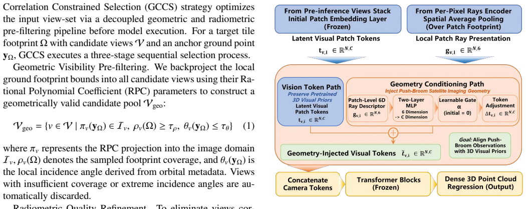
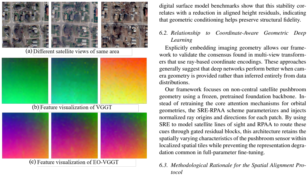
EO-VGGT adapts a frozen perspective-driven 3D foundation model to orbital observations via explicit physical geometry embedding: the Geometry-Correlation Constrained Selection prunes sub-optimal observations by balancing geometric diversity and radiometric consistency, the Sensor-Ray Encoder parameterizes pixel-level pushbroom lines of sight from the Rational Function Model into high-dimensional space-geometric tokens, and the Ray-Pointing-Aware Adapter uses gated residual blocks to integrate these tokens into the transformer backbone.
What carries the argument
The Sensor-Ray Encoder (SRE), which parameterizes pixel-level pushbroom lines of sight derived from the Rational Function Model into high-dimensional space-geometric tokens to reconcile central projection assumptions with orbital kinematics.
If this is right
- Feed-forward 3D reconstruction from satellite multi-view optical imagery becomes feasible without full model retraining.
- Input sequences are optimized by pruning views that fail to balance geometric diversity and radiometric consistency.
- Pre-trained perspective models can be reused for orbital data once ray tokens are injected through a lightweight adapter.
- High-quality Digital Surface Model generation is supported directly from Earth Observation constellation imagery.
Where Pith is reading between the lines
- The same ray-token approach could extend to other non-central-projection sensors such as SAR or line-scan systems.
- View-selection criteria balancing geometry and radiometry may scale to processing very large satellite image collections efficiently.
- Conditioning on explicit rays may reduce systematic artifacts in reconstructed surfaces compared with purely learned implicit methods.
Load-bearing premise
The Rational Function Model can be directly parameterized into high-dimensional tokens without introducing unmanageable errors that prevent reconciliation between central projection and orbital pushbroom geometry.
What would settle it
Reconstruction accuracy measured on held-out satellite multi-view datasets with the Sensor-Ray Encoder ablated versus the full model, checking whether error metrics rise sharply when the ray parameterization is removed.
Figures

read the original abstract
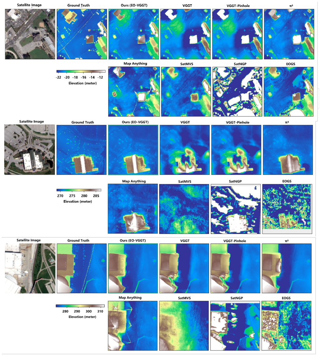
In the era of satellite constellations, multi-view optical satellite imagery is pivotal for Earth Observation (EO) and high-quality Digital Surface Model (DSM) reconstruction. Although feed-forward 3D foundation models have transformed computer vision, their deployment in satellite remote sensing is inherently constrained by the structural discrepancy between implicit perspective assumptions and explicit orbital pushbroom geometry. This geometric incongruity is further compounded by pronounced view-set heterogeneity. We present EO-VGGT, a framework that adapts a frozen perspective-driven model to orbital observations via explicit physical geometry embedding.First, the Geometry-Correlation Constrained Selection (GCCS) strategy prunes sub-optimal observations by balancing geometric diversity and radiometric consistency to optimize the input sequence. Second, a Sensor-Ray Encoder (SRE) parameterizes pixel-level pushbroom lines of sight derived from the Rational Function Model (RFM) into high-dimensional space-geometric tokens, reconciling the mathematical discrepancy between central projection and orbital kinematics. Third, a lightweight Ray-Pointing-Aware Adapter (RPAA) employs gated residual blocks to integrate these tokens directly into the frozen transformer backbone. Our findings underscore that integrating explicit physical geometry with optimized view selection is essential for robust feed-forward satellite 3D reconstruction.
Editorial analysis
A structured set of objections, weighed in public.
Referee Report
Summary. The manuscript introduces EO-VGGT, a framework adapting a frozen perspective-driven 3D foundation model to satellite pushbroom imagery for multi-view reconstruction. It proposes three components: Geometry-Correlation Constrained Selection (GCCS) to prune views by balancing geometric diversity and radiometric consistency; Sensor-Ray Encoder (SRE) to parameterize pixel-level pushbroom lines of sight from the Rational Function Model (RFM) into high-dimensional space-geometric tokens; and Ray-Pointing-Aware Adapter (RPAA) using gated residual blocks to inject these tokens into the transformer backbone. The central claim is that integrating explicit physical geometry with optimized view selection is essential for robust feed-forward satellite 3D reconstruction.
Significance. If the adaptation succeeds without destroying learned priors, the work could enable direct transfer of terrestrial 3D foundation models to orbital data, addressing a key barrier in Earth observation. The explicit RFM-based ray tokenization offers a concrete mechanism for injecting orbital kinematics, which is a strength if accompanied by reproducible code or parameter-free derivations. However, the absence of any reported metrics, ablations, datasets, or error analysis in the manuscript prevents assessment of whether the approach delivers measurable gains over existing satellite DSM methods.
major comments (3)
- [Abstract] Abstract: the manuscript states conclusions about robustness and the 'essential' status of geometry integration but supplies no quantitative results, ablation studies, error metrics, or validation details. This is load-bearing because the central claim cannot be evaluated without evidence that SRE and RPAA achieve the claimed reconciliation.
- [Abstract] Abstract (SRE description): the Sensor-Ray Encoder is said to 'parameterize pixel-level pushbroom lines of sight derived from the Rational Function Model (RFM) into high-dimensional space-geometric tokens,' yet no functional form, ray-direction deviation bounds, reprojection residual analysis, or sensitivity to RPC coefficient noise is provided. This step is load-bearing for the claim that explicit orbital geometry can be injected into a frozen perspective backbone without unmanageable approximation error.
- [Abstract] Abstract (overall validation): no experiments, datasets (e.g., specific satellite constellations or DSM benchmarks), or comparisons to prior satellite 3D methods are referenced, leaving the assertion that the integration is 'essential' unsupported by any falsifiable prediction or empirical test.
minor comments (1)
- [Abstract] Acronyms (GCCS, SRE, RPAA, RFM, DSM, EO) are introduced without expansion on first use in the abstract; this should be corrected for readability.
Simulated Author's Rebuttal
We thank the referee for the careful reading and constructive comments focused on the abstract. We agree that the abstract as currently written is too high-level and does not sufficiently preview the empirical support for the central claims. We will revise the abstract to incorporate concise references to quantitative results, ablation outcomes, datasets, and validation details from the full manuscript while preserving its brevity.
read point-by-point responses
-
Referee: [Abstract] Abstract: the manuscript states conclusions about robustness and the 'essential' status of geometry integration but supplies no quantitative results, ablation studies, error metrics, or validation details. This is load-bearing because the central claim cannot be evaluated without evidence that SRE and RPAA achieve the claimed reconciliation.
Authors: We accept the observation. The abstract summarizes the framework but omits the supporting numbers. In the revised version we will add a sentence referencing the key metrics (e.g., DSM RMSE reductions on benchmark satellite datasets), the ablation results demonstrating the contribution of GCCS, SRE, and RPAA, and the validation protocol, thereby making the claim of essential geometry integration directly traceable to evidence. revision: yes
-
Referee: [Abstract] Abstract (SRE description): the Sensor-Ray Encoder is said to 'parameterize pixel-level pushbroom lines of sight derived from the Rational Function Model (RFM) into high-dimensional space-geometric tokens,' yet no functional form, ray-direction deviation bounds, reprojection residual analysis, or sensitivity to RPC coefficient noise is provided. This step is load-bearing for the claim that explicit orbital geometry can be injected into a frozen perspective backbone without unmanageable approximation error.
Authors: The functional form of the SRE (RFM-derived ray parameterization into tokens) and the associated error analysis appear in Section 3.2 and the supplementary material. To address the concern directly in the abstract, we will append a short clause noting that the ray tokens are derived from the standard RFM with bounded reprojection residuals and that sensitivity to RPC noise was quantified in the experiments. This keeps the abstract concise while signaling the supporting analysis. revision: yes
-
Referee: [Abstract] Abstract (overall validation): no experiments, datasets (e.g., specific satellite constellations or DSM benchmarks), or comparisons to prior satellite 3D methods are referenced, leaving the assertion that the integration is 'essential' unsupported by any falsifiable prediction or empirical test.
Authors: We agree that the abstract should reference the experimental setting. The revised abstract will name the satellite datasets and constellations used, the DSM benchmarks, and the comparison baselines (both traditional satellite DSM pipelines and adapted terrestrial models). This will make the empirical grounding of the 'essential' claim explicit without expanding the abstract beyond acceptable length. revision: yes
Circularity Check
No circularity: framework components presented as independent adaptations
full rationale
The paper describes EO-VGGT as a new framework introducing GCCS for view selection, SRE for parameterizing RFM-derived rays into tokens, and RPAA for integrating them into a frozen backbone. No equations, fitted parameters, or self-citations appear in the provided text that would reduce any claimed result to an input by construction. The central claims rest on the proposed architectural choices rather than tautological re-derivations or load-bearing self-references, making the derivation self-contained against external benchmarks.
Axiom & Free-Parameter Ledger
Reference graph
Works this paper leans on
-
[1]
and Brown, Myron , booktitle=
Bosch, Marc and Foster, Kevin and Christie, Gordon and Wang, Sean and Hager, Gregory D. and Brown, Myron , booktitle=. Semantic Stereo for Incidental Satellite Images , year=
-
[2]
Rational Polynomial Camera Model Warping for Deep Learning Based Satellite Multi-View Stereo Matching , year=
Gao, Jian and Liu, Jin and Ji, Shunping , booktitle=. Rational Polynomial Camera Model Warping for Deep Learning Based Satellite Multi-View Stereo Matching , year=
-
[3]
Leveraging Vision Reconstruction Pipelines for Satellite Imagery , year=
Zhang, Kai and Snavely, Noah and Sun, Jin , booktitle=. Leveraging Vision Reconstruction Pipelines for Satellite Imagery , year=
-
[4]
Gaussian Splatting for Efficient Satellite Image Photogrammetry , year=
Aira, Luca Savant and Facciolo, Gabriele and Ehret, Thibaud , booktitle=. Gaussian Splatting for Efficient Satellite Image Photogrammetry , year=
-
[5]
d'Angelo, Pablo and Rossi, Cristian and Minet, Christian and Eineder, Michael and Flory, Michael and Niemeyer, Irmgard , year =
-
[6]
Operational Generation of High-Resolution Digital Surface Models from Commercial Tri-Stereo Satellite Data , isbn =
Carl, Sebastian and Bärisch, Samuel and Lang, Florian and d'Angelo, Pablo and Arefi, Hossein and Reinartz, Peter , year =. Operational Generation of High-Resolution Digital Surface Models from Commercial Tri-Stereo Satellite Data , isbn =
-
[7]
SAT-NGP : Unleashing Neural Graphics Primitives for Fast Relightable Transient-Free 3D Reconstruction From Satellite Imagery , year=
Billouard, Camille and Derksen, Dawa and Sarrazin, Emmanuelle and Vallet, Bruno , booktitle=. SAT-NGP : Unleashing Neural Graphics Primitives for Fast Relightable Transient-Free 3D Reconstruction From Satellite Imagery , year=
-
[8]
and Landgraf, S
Wu, X. and Landgraf, S. and Ulrich, M. and Qin, R. , title =. Geo-spatial Information Science , year =
-
[9]
Double Propagation Stereo Matching for Urban 3-D Reconstruction From Satellite Imagery , year=
Zhao, Li and Liu, Yongmei and Men, Chaoguang and Men, Yubo , journal=. Double Propagation Stereo Matching for Urban 3-D Reconstruction From Satellite Imagery , year=
-
[10]
Corinne Stucker and Konrad Schindler , keywords =. ResDepth: A deep residual prior for 3D reconstruction from high-resolution satellite images , journal =. 2022 , issn =. doi:https://doi.org/10.1016/j.isprsjprs.2021.11.009 , url =
-
[11]
and Wang, T
Sun, H. and Wang, T. and Cheng, Q. and Huang, J. , title =. ISPRS Journal of Photogrammetry and Remote Sensing , volume =
-
[12]
and Li, S
He, S. and Li, S. and Jiang, S. and Jiang, W. , title =. ISPRS Journal of Photogrammetry and Remote Sensing , volume =
-
[13]
and Men, Y
Zhao, L. and Men, Y. and Zhu, Y. and Wang, H. and Men, C. , title =. IEEE Transactions on Geoscience and Remote Sensing , volume =
-
[14]
and Chen, H
Yang, S. and Chen, H. and He, F. and Chen, W. and Chen, T. and He, J. , title =. IEEE Journal of Selected Topics in Applied Earth Observations and Remote Sensing , volume =
-
[15]
MVSR3D: An End-to-End Framework for Semantic 3-D Reconstruction Using Multiview Satellite Imagery , year=
Huang, Xuejun and Liu, Xinyi and Wan, Yi and Zheng, Zhi and Zhang, Bin and Wang, Yameng and Guo, Haoyu and Zhang, Yongjun , journal=. MVSR3D: An End-to-End Framework for Semantic 3-D Reconstruction Using Multiview Satellite Imagery , year=
-
[16]
and Yan, Y
Zhang, C. and Yan, Y. and Zhao, C. and Su, N. and Zhou, W. , title =. IEEE Transactions on Geoscience and Remote Sensing , volume =
-
[17]
European Journal of Remote Sensing , volume =
Thomas Krauß and Pablo D’Angelo and Lorenz Wendt , title =. European Journal of Remote Sensing , volume =. 2019 , publisher =. doi:10.1080/22797254.2018.1551069 , URL =
-
[18]
A critical analysis of satellite stereo pairs for digital surface model generation and a matching quality prediction model , journal =. 2019 , issn =. doi:https://doi.org/10.1016/j.isprsjprs.2019.06.005 , url =
-
[19]
DUSt3R: Geometric 3D Vision Made Easy , year=
Wang, Shuzhe and Leroy, Vincent and Cabon, Yohann and Chidlovskii, Boris and Revaud, Jerome , booktitle=. DUSt3R: Geometric 3D Vision Made Easy , year=
-
[20]
VGGT: Visual Geometry Grounded Transformer , year=
Wang, Jianyuan and Chen, Minghao and Karaev, Nikita and Vedaldi, Andrea and Rupprecht, Christian and Novotny, David , booktitle=. VGGT: Visual Geometry Grounded Transformer , year=
-
[21]
Yifan Wang and Jianjun Zhou and Haoyi Zhu and Wenzheng Chang and Yang Zhou and Zizun Li and Junyi Chen and Jiangmiao Pang and Chunhua Shen and Tong He , booktitle=. \. 2026 , url=
2026
-
[22]
uller and Johannes Sch\
Nikhil Keetha and Norman M\"uller and Johannes Sch\"onberger and Lorenzo Porzi and Yuchen Zhang and Tobias Fischer and Arno Knapitsch and Duncan Zauss and Ethan Weber and Nelson Antunes and Jonathon Luiten and Manuel Lopez-Antequera and Samuel Rota Bul\`o and Christian Richardt and Deva Ramanan and Sebastian Scherer and Peter Kontschieder , booktitle =. 2...
2026
-
[23]
Li, K. and others , title =. arXiv preprint , year =. 2601.15275 , archivePrefix =
-
[24]
Segre, L. and Hirschorn, O. and Avidan, S. , title =. arXiv preprint , year =. 2512.15708 , archivePrefix =
-
[25]
Sat-DN: Implicit Surface Reconstruction From Multiview Satellite Images With Depth and Normal Supervision , year=
Liu, Tianle and Zhao, Shuangming and Jiang, Wanshou and Guo, Bingxuan , journal=. Sat-DN: Implicit Surface Reconstruction From Multiview Satellite Images With Depth and Normal Supervision , year=
-
[26]
and D'Angelo, P
Krauss, T. and D'Angelo, P. and Wendt, L. , title =. ISPRS Annals of the Photogrammetry, Remote Sensing and Spatial Information Sciences , volume =. 2014 , note =
2014
-
[27]
ISPRS Journal of Photogrammetry and Remote Sensing , volume=
3D change detection--approaches and applications , author=. ISPRS Journal of Photogrammetry and Remote Sensing , volume=. 2016 , publisher=
2016
-
[28]
SemiCDNet: A Semisupervised Convolutional Neural Network for Change Detection in High Resolution Remote-Sensing Images , volume =
Peng, Daifeng and Bruzzone, Lorenzo and Guan, Haiyan and Ding, Haiyong and Huang, Xu , year =. SemiCDNet: A Semisupervised Convolutional Neural Network for Change Detection in High Resolution Remote-Sensing Images , volume =. IEEE Transactions on Geoscience and Remote Sensing , doi =
-
[29]
Geo-spatial Information Science , volume =
Xinyi Wu and Steven Landgraf and Markus Ulrich and Rongjun Qin , title =. Geo-spatial Information Science , volume =. 2025 , publisher =. doi:10.1080/10095020.2025.2597491 , URL =
-
[30]
Proceedings of the IEEE/CVF International Conference on Computer Vision (ICCV) , month =
Qian, Ming and Xiong, Jincheng and Xia, Gui-Song and Xue, Nan , title =. Proceedings of the IEEE/CVF International Conference on Computer Vision (ICCV) , month =. 2023 , pages =
2023
-
[31]
Seeing through Satellite Images at Street Views , year=
Qian, Ming and Tan, Bin and Wang, Qiuyu and Zheng, Xianwei and Xiong, Hanjiang and Xia, Gui-Song and Shen, Yujun and Xue, Nan , journal=. Seeing through Satellite Images at Street Views , year=
-
[32]
Remote Sensing , VOLUME =
Huang, Xu and Wan, Xue and Peng, Daifeng , TITLE =. Remote Sensing , VOLUME =. 2020 , NUMBER =
2020
-
[33]
Remote Sensing , VOLUME =
Gong, Danchao and Huang, Xu and Zhang, Jidan and Yao, Yongxiang and Han, Yilong , TITLE =. Remote Sensing , VOLUME =. 2022 , NUMBER =
2022
-
[34]
Ting Han and Chenxi Du and Yijia Xie and Xinyan Xian and Xinchang Zhang and Bisheng Yang and Yiping Chen , keywords =. A 3D perspective for understanding the mechanisms of urban heat island and urban morphology using multi-modal geospatial data and interpretable machine learning , journal =. 2025 , issn =. doi:https://doi.org/10.1016/j.buildenv.2025.11318...
-
[35]
Progressive Learning-Based Jitter Distortion Correction for Remote Sensing Images of Time Delay and Integration Camera , year=
Zhu, Ying and Wang, Hao and Wang, Mi and Pan, Jun and Hong, Hanyu and Ma, Lei and Wang, Lei , journal=. Progressive Learning-Based Jitter Distortion Correction for Remote Sensing Images of Time Delay and Integration Camera , year=
-
[36]
GLS–MIFT: A modality invariant feature transform with global-to-local searching , journal =
Zhongli Fan and Yingdong Pi and Mi Wang and Yifei Kang and Kai Tan , keywords =. GLS–MIFT: A modality invariant feature transform with global-to-local searching , journal =. 2024 , issn =. doi:https://doi.org/10.1016/j.inffus.2024.102252 , url =
-
[37]
A Robust Oriented Filter-Based Matching Method for Multisource, Multitemporal Remote Sensing Images , year=
Fan, Zhongli and Wang, Mi and Pi, Yingdong and Liu, Yuxuan and Jiang, Huiwei , journal=. A Robust Oriented Filter-Based Matching Method for Multisource, Multitemporal Remote Sensing Images , year=
-
[38]
MAMHESet: A Multiangle Monocular Height Estimation Dataset From Luojia3-01 Video Satellite , year=
Wang, Xinsheng and Pi, Yingdong and Wang, Mi and Zhao, Yan and Cheng, Xu and Zhou, Tiyou and Zhao, Jianping , journal=. MAMHESet: A Multiangle Monocular Height Estimation Dataset From Luojia3-01 Video Satellite , year=
-
[39]
A Multiscale Framework With Unsupervised Learning for Remote Sensing Image Registration , year=
Ye, Yuanxin and Tang, Tengfeng and Zhu, Bai and Yang, Chao and Li, Bo and Hao, Siyuan , journal=. A Multiscale Framework With Unsupervised Learning for Remote Sensing Image Registration , year=
-
[40]
Proceedings of the IEEE/CVF Conference on Computer Vision and Pattern Recognition (CVPR) , month =
Li, Weijia and Yang, Haote and Hu, Zhenghao and Zheng, Juepeng and Xia, Gui-Song and He, Conghui , title =. Proceedings of the IEEE/CVF Conference on Computer Vision and Pattern Recognition (CVPR) , month =. 2024 , pages =
2024
-
[41]
Large-Scale Planar Block Adjustment of GaoFen1 WFV Images Covering Most of Mainland China , year=
Pi, Yingdong and Yang, Bo and Li, Xin and Wang, Mi and Cheng, Yufeng , journal=. Large-Scale Planar Block Adjustment of GaoFen1 WFV Images Covering Most of Mainland China , year=
-
[42]
Relative Geometric Refinement of Patch Images Without Use of Ground Control Points for the Geostationary Optical Satellite GaoFen4 , year=
Yang, Bo and Pi, Yingdong and Li, Xin and Wang, Mi , journal=. Relative Geometric Refinement of Patch Images Without Use of Ground Control Points for the Geostationary Optical Satellite GaoFen4 , year=
-
[43]
HSROSS: A Benchmark for Feature Matching Algorithms of High-Resolution Optical Satellites in Challenging Scenarios , year=
Luo, Qiyan and Zhang, Jidan and Wang, Mi and Fan, Zhongli , journal=. HSROSS: A Benchmark for Feature Matching Algorithms of High-Resolution Optical Satellites in Challenging Scenarios , year=
-
[44]
Comparative Analysis of Advanced Feature Matching Algorithms in Challenging High Spatial Resolution Optical Satellite Stereo Scenarios , year=
Luo, Qiyan and Zhang, Jidan and Xie, Yuzhen and Huang, Xu and Han, Ting , booktitle=. Comparative Analysis of Advanced Feature Matching Algorithms in Challenging High Spatial Resolution Optical Satellite Stereo Scenarios , year=
-
[45]
SEGPR: Semantic-Enhanced Geopositioning Refinement of Satellite Geographic Products by Combining Multitemporal Coarse-Accuracy Geographic Base Maps , year=
Luo, Qiyan and Zhang, Jidan and Huang, Xu and Zhu, Liangchen and Xie, Yuzhen and Hu, Tongxi , journal=. SEGPR: Semantic-Enhanced Geopositioning Refinement of Satellite Geographic Products by Combining Multitemporal Coarse-Accuracy Geographic Base Maps , year=
-
[46]
Proceedings of the AAAI Conference on Artificial Intelligence , volume=
SkySplat: Generalizable 3D Gaussian splatting from multi-temporal sparse satellite images , author=. Proceedings of the AAAI Conference on Artificial Intelligence , volume=
-
[47]
2026 , eprint=
Geometric Consistency Protocol for Foundation Model Features in Multi-View Satellite Imagery , author=. 2026 , eprint=
2026
-
[48]
Luojia 3-01 Satellite—Real-Time Intelligent Service System for Remote Sensing Science Experiment Satellite , year=
Wang, Mi and Wu, Qianyu and Xiao, Jing and Li, Deren and Yang, Fang , journal=. Luojia 3-01 Satellite—Real-Time Intelligent Service System for Remote Sensing Science Experiment Satellite , year=
-
[49]
Geo-spatial Information Science , volume =
Li,Deren and Wang, Mi and Dong, Zhipeng and Shen, Xin and Shi, Lite , title =. Geo-spatial Information Science , volume =. 2017 , publisher =
2017
discussion (0)
Sign in with ORCID, Apple, or X to comment. Anyone can read and Pith papers without signing in.