REVIEW 4 major objections 5 minor 31 references
Deep Learning based Wearable Assistive System for Visually Impaired People
T0 review · 4 major / 5 minor · reviewed 2026-08-14 · deepseek-v4-flash
Pith's one-line read A deep-learning wearable system for visually impaired people predicts walkable directions from RGBD video plus semantic segmentation maps and reports up to 99.6% accuracy with zero collisions in a hallway study.
desk verdict A useful assistive system with real user-study evidence, but the high classification accuracies reflect a camera-orientation labeling heuristic rather than proven collision-free safety. read the letter →
The pith
A machine-rendered reading of the paper's core claim, the machinery that carries it, and where it could break.
The reading
What carries the argument
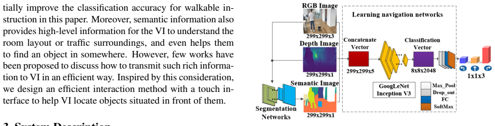
The mechanism that carries the argument is a five-channel input tensor formed by stacking the RGB frame, the depth frame, and the semantic segmentation map (three RGB channels plus depth and one segmentation channel). A convolutional network is trained end-to-end on these stacked inputs to output three probabilities, and the largest probability selects the walking instruction. The semantic segmentation part is what does the extra work: it labels floors, walls, people, and low objects like curbs, so the navigation network can react to hazards that depth alone cannot resolve, such as glass walls and missing depth values.
What would settle it
Run the trained system in a corridor with obstacles on both sides and a clear path straight ahead; if the network outputs a turn command or the user collides despite the clear straight path, the claimed collision-free behavior fails.
Extended reading notes
Core claim
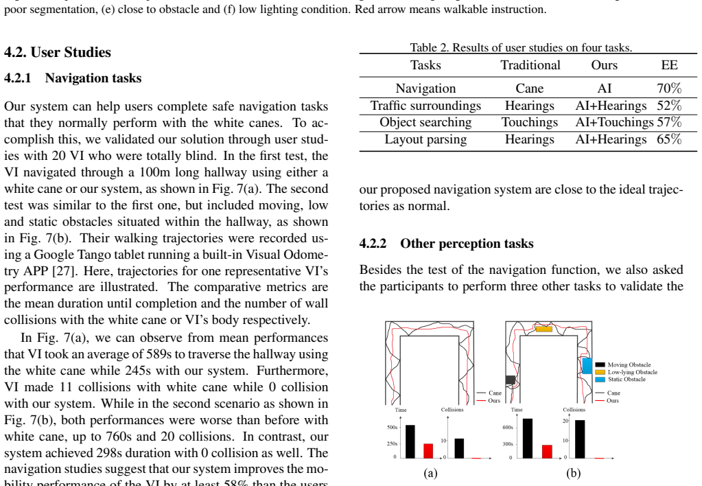
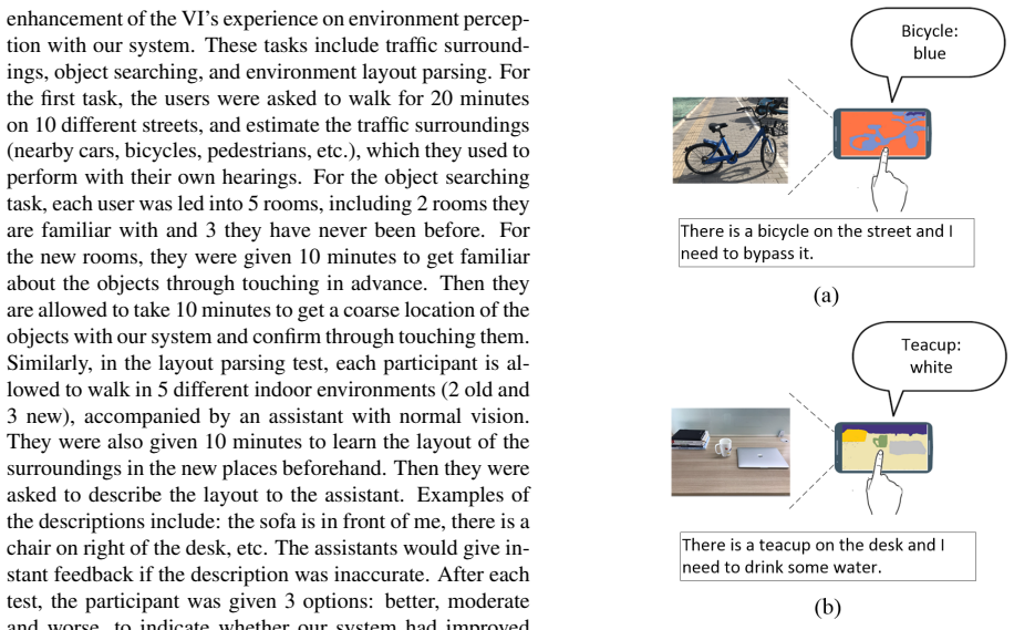
The central claim is that adding a semantic segmentation map to RGBD input lets an end-to-end convolutional network predict a safe walking instruction — turn left, go straight, or turn right — even when depth information is degraded or when the obstacle is too low for traditional depth-based detectors to see. Trained on images captured by a sighted pilot walking without collisions, the network achieves the reported accuracies across indoor and outdoor day/night conditions, poor-depth frames, and low-obstacle frames. In user studies with 20 blind participants, the system produced zero wall or body collisions while the white cane produced 11 and 20 collisions in two hallway scenarios, with completion times roughly 58% faster. The paper also claims that the same semantic map, presented on a touchscreen with distance-dependent audio volume, helps users perceive room layout and locate objects.
Load-bearing premise
The system assumes that the correct walking direction can be read from which side an obstacle appears on in the camera image.
Editorial extensions
If this is right
- If the result transfers beyond the collected datasets, semantic segmentation becomes a workable substitute for reliable depth in wearable obstacle avoidance.
- Blind users can complete structured indoor routes faster and with fewer collisions than with a white cane alone.
- A single semantic map can serve both navigation and scene understanding, letting users query objects and distances by touch.
- The reported inference speeds (about 25 fps for segmentation and 10 ms per navigation decision) are fast enough for real-time audio feedback while walking.
Reading between the lines
- The classification accuracies probably overstate true navigation safety, because the labels are generated by the rule that an object on one side means turn the other way; that rule is ambiguous when obstacles are on both sides or when going straight between them is the only safe action.
- The zero-collision user study is a single 100-meter hallway and should not be read as evidence for stairs, crowds, street crossings, or outdoor uneven terrain.
- A natural next step the paper does not explore is replacing the three fixed commands with continuous steering or speed control, which would let the network express more nuanced paths.
Signed reviews
Editorial analysis
A structured set of objections, weighed in public.
Referee Report
Summary. The paper proposes a wearable assistive system for visually impaired users built from an RGBD camera, an earphone, and a smartphone. The core technical contribution is a deep convolutional network (based on GoogLeNet) that takes RGB, depth, and semantic-segmentation images as a five-channel input and outputs three steering instructions: turn left, go straight, and turn right. The semantic segmentation is produced by a retrained FuseNet, and the navigation network is trained on self-collected indoor and outdoor datasets that include day/night conditions, poor-depth frames, and low-lying obstacles. The system also provides a touch-based interaction for object and layout information. The authors report classification accuracies of 97.9-99.6% across six test scenarios (Table 1), compare against three baselines, and present user studies with 20 totally blind participants, including a hallway navigation test with zero collisions and faster traversal than with a white cane. The paper claims that the system provides safe and collision-free navigation feedback, especially for low-lying obstacles.
Significance. If the central claim were established, the system would be a valuable contribution to wearable assistive technology: combining RGBD input with semantic segmentation to handle low-lying obstacles and poor depth is a plausible and practically relevant idea, and the user study with 20 totally blind participants is a genuine strength. The self-collected datasets covering day/night, low obstacles, and poor depth are also useful resources for the community. The paper demonstrates real-time inference and integrates the perception with a touch-based interface, which is a meaningful system-level contribution. However, the significance is currently bounded by the evaluation design: the high classification accuracies are measured against a labeling heuristic rather than against verified safe navigation, and the user study is limited to a single relatively simple hallway setting.
major comments (4)
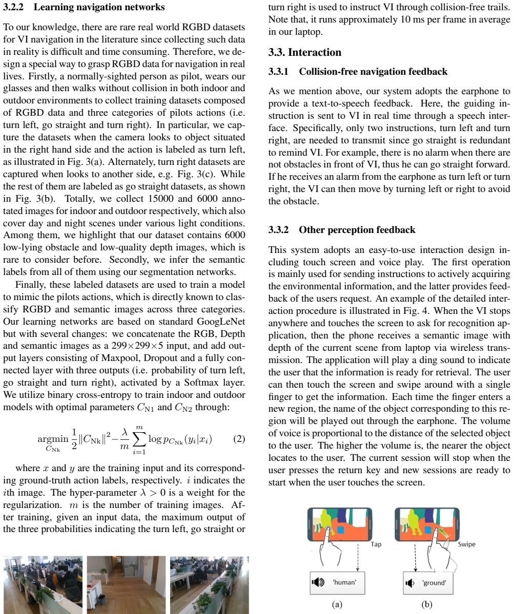
- [Section 3.2.2, Eq. (2), Table 1] The navigation labels are generated by the pilot's camera-orientation rule: 'we capture the datasets when the camera looks to object situated in the right hand side and the action is labeled as turn left,' and symmetrically for turn right, with all other frames labeled go straight. The network in Eq. (2) is trained and evaluated on labels produced by this same rule. Consequently, the 97.9-99.6% accuracies in Table 1 demonstrate that the network can reproduce the pilot's laterality heuristic, not that the resulting instruction is collision-free. The rule is not a safe-navigation ground truth in cases such as obstacles on both sides, a safe straight path through a narrow gap, or an obstacle that has already been passed, and the paper does not show that such cases are included in the splits. To support the central claim, the training and test labels should be generated from a verified safety criterion (for example, labels derived from planned collision-free trajectories or from independent human judgments of walkable direction), and the evaluation should explicitly include ambiguous scenarios.
- [Section 4.2.1, Figure 7, Table 2] The user study is the main independent evidence for the safety claim, but it is limited to one 100-m hallway with turns and, in the second condition, some obstacles. The paper reports mean completion times and collision counts (589 s vs. 245 s and 11 vs. 0 collisions in the first condition) without confidence intervals, per-participant variance, or statistical significance tests. It does not state whether the order of conditions was counterbalanced, how participants were trained on the system, or whether the assistant walked with the participants in the system condition. The single representative trajectory in Figure 7 is not sufficient to assess trajectory quality. This evaluation is supportive but does not establish that the system is collision-free in general, especially in the ambiguous situations where the labeling heuristic of Section 3.2.2 fails.
- [Section 4.1.2, Table 1] The comparison with baselines is not sufficiently specified. RGB-C is taken from a UAV forest-navigation work [6], Depth-T is the traditional method of [3], and RGBD-C is an ablation variant, but the paper does not state whether the external baselines were retrained on the authors' datasets, how hyperparameters were selected, or how the traditional method was adapted to the new sensor and environments. Since the central quantitative claim is that RGBDS outperforms all baselines, the lack of a described, fair training/adaptation protocol for the baselines, combined with the absence of error bars and the number of test frames per scenario, weakens the comparison.
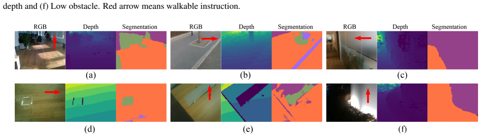
- [Section 3.2.1, Section 4.1.3, Figure 6] The semantic segmentation network is essential to the claimed advantage for low-lying obstacles and poor depth, but its accuracy is never evaluated on the self-collected data. The paper states that the segmentation results compensate for missing depth (Section 4.1.2) and that poor segmentation leads to wrong instructions (Section 4.1.3 and Figure 6(d)), yet no segmentation metrics (e.g., IoU, pixel accuracy) or per-class results are reported. Without this evaluation, it is not possible to attribute the navigation gains to the semantic map rather than to some other property of the five-channel input, or to assess how often segmentation errors will cause unsafe instructions in practice.
minor comments (5)
- [Table 1] The table would benefit from reporting the number of test frames per scenario, class-wise accuracies, and standard deviations or confidence intervals, since the six reported numbers are point estimates without any measure of variability.
- [Section 3.2.1] There are several typos and inconsistencies in dataset names: 'Scannet' and 'Cityspace' should be 'ScanNet' and 'Cityscapes', and the sentence 'we infer the semantic labels from all of them using our segmentation networks' (Section 3.2.2) should clarify that these are automatic predictions, not ground-truth labels.
- [Section 4.2.2, Table 2] The 'EE' percentages in Table 2 are reported without the number of responses or the distribution of 'better', 'moderate', and 'worse' answers, so it is unclear how much weight to give to these subjective results.
- [Section 4.1.3, Section 5] The paper's own limitations (wrong instructions near walls, in low light, and when segmentation is poor, and the future plan to add sonar or bump sensors 'to confirm safety in some extreme case') should be reflected in the abstract and conclusion, where the system is currently described as providing 'collision-free' instructions.
- [Figure 7] The navigation trajectories are shown for 'one representative VI's performance'; clarifying whether the reported 589 s/245 s and collision counts are means over all 20 participants, and adding per-participant plots or variance information, would make the user study more interpretable.
Circularity Check
High classification accuracy is measured against the authors' own 'camera looks at object on one side' labeling rule, not against an independent collision-free safety criterion; a limited hallway user study provides partial independent support.
-
fitted input called prediction
[Section 3.2.2 (Learning navigation networks); evaluation in Section 4.1.1 and Table 1]
"we capture the datasets when the camera looks to object situated in the right hand side and the action is labeled as turn left, as illustrated in Fig. 3(a). Alternately, turn right datasets are captured when looks to another side, e.g. Fig. 3(c). While the rest of them are labeled as go straight datasets, as shown in Fig. 3(b). ... Finally, these labeled datasets are used to train a model to mimic the pilots actions, which is directly known to classify RGBD and semantic images across three categories."
The ground-truth action labels are generated by a laterality rule: any frame in which the pilot's camera points to an object on the right is labeled 'turn left', the symmetric case is labeled 'turn right', and everything else is 'go straight'. The network is trained to reproduce these labels and then scored on held-out images collected under the same capture rule. High ACA therefore measures how well the network predicts the authors' own camera-orientation labeling heuristic, not whether the resulting instruction is collision-free; the rule is wrong in cases such as obstacles on both sides, a safe straight path through a narrow gap, or an obstacle already passed.
full rationale
The main quantitative claim is partially circular: the classification target is defined by the authors' capture rule, so the high test accuracy is a measure of consistency with that rule rather than an independent measure of collision-free safety. However, this is not a case of self-citation load-bearing or imported uniqueness: the segmentation network is an external architecture (FuseNet [14]) trained on external datasets (ScanNet, Cityscapes) plus the authors' own fine-tuning frames, and no load-bearing argument relies on the authors' prior papers. The user study (20 totally blind participants, zero collisions, faster traversal than white cane in a 100m hallway) is an independent behavioral check and prevents the safety claim from being entirely definitional, although it is limited to one simple hallway and does not cover the ambiguous cases where the labeling heuristic fails. The paper also acknowledges wrong instructions near walls, in low light, and with poor segmentation, and defers additional confirmation sensors to future work. Overall, the circularity is real but partial: the accuracy numbers are self-consistent with the label rule, while the user study provides independent, if narrow, support.
Assumptions & free parameters
assumptions (4)
- ad hoc to paper The pilot's camera-orientation rule produces valid ground-truth labels for safe navigation.
- domain assumption The semantic segmentation network (FuseNet) provides reliable semantic maps in deployment.
- domain assumption The self-collected test datasets are representative of real-world VI walking conditions and visually different from training.
- domain assumption The Inuitive M3.2 RGBD camera provides accurate depth in indoor and outdoor conditions.
Cite this review
Pith. "Pith review of Deep Learning based Wearable Assistive System for Visually Impaired People." pith.science (2026). https://pith.science/paper/DNNO4YRR
@misc{pith2026190803364,
  author       = {Pith},
  title        = {Pith review of: Deep Learning based Wearable Assistive System for Visually Impaired People},
  year         = {2026},
  howpublished = {\url{https://pith.science/paper/DNNO4YRR}},
  note         = {Machine review of arXiv:1908.03364}
}
read the original abstract
In this paper, we propose a deep learning based assistive system to improve the environment perception experience of visually impaired (VI). The system is composed of a wearable terminal equipped with an RGBD camera and an earphone, a powerful processor mainly for deep learning inferences and a smart phone for touch-based interaction. A data-driven learning approach is proposed to predict safe and reliable walkable instructions using RGBD data and the established semantic map. This map is also used to help VI understand their 3D surrounding objects and layout through well-designed touchscreen interactions. The quantitative and qualitative experimental results show that our learning based obstacle avoidance approach achieves excellent results in both indoor and outdoor datasets with low-lying obstacles. Meanwhile, user studies have also been carried out in various scenarios and showed the improvement of VI's environment perception experience with our system.
Figures

Figures from the paper (4 more)

Reference graph
Works this paper leans on
-
[6]
L. Chen, W. Wang, and J. Zhu. Learning transferable uav for forest visual perception. In Proceedings of the 27th In- ternational Joint Conference on Artificial Intelligence, pages 4883–4889. AAAI Press, 2018
work page 2018
-
[3]
J. Bai, S. Lian, Z. Liu, K. Wang, and D. Liu. Smart guiding glasses for visually impaired people in indoor environment. IEEE Transactions on Consumer Electronics , 63(3):258– 266, 2017
work page 2017
-
[1]
M. S. Aman, M. A. Mahmud, H. Jiang, A. Abdelgawad, and K. Yelamarthi. A sensor fusion methodology for obstacle avoidance robot. In 2016 IEEE International Conference on Electro Information Technology (EIT), pages 0458–0463. IEEE, 2016
work page 2016
-
[2]
Badrinarayanan, A
V . Badrinarayanan, A. Kendall, and R. Cipolla. Segnet: A deep convolutional encoder-decoder architecture for image segmentation. IEEE transactions on pattern analysis and machine intelligence, 39(12):2481–2495, 2017
2017
-
[4]
J. Bai, Z. Liu, Y . Lin, Y . Li, S. Lian, and D. Liu. Wearable travel aid for environment perception and navigation of visu- ally impaired people. Electronics, 8(6):697, 2019
work page 2019
- [5]
-
[7]
L.-C. Chen, G. Papandreou, I. Kokkinos, K. Murphy, and A. L. Yuille. Deeplab: Semantic image segmentation with deep convolutional nets, atrous convolution, and fully con- nected crfs. IEEE transactions on pattern analysis and ma- chine intelligence, 40(4):834–848, 2018
2018
-
[8]
Cordts, M
M. Cordts, M. Omran, S. Ramos, T. Rehfeld, M. Enzweiler, R. Benenson, U. Franke, S. Roth, and B. Schiele. The cityscapes dataset for semantic urban scene understanding. In Proceedings of the IEEE conference on computer vision and pattern recognition, pages 3213–3223, 2016
2016
Show all 31 references
-
[9]
A. Dai, A. X. Chang, M. Savva, M. Halber, T. Funkhouser, and M. Nießner. Scannet: Richly-annotated 3d reconstruc- tions of indoor scenes. In Proceedings of the IEEE Con- ference on Computer Vision and Pattern Recognition, pages 5828–5839, 2017
2017
-
[10]
Elmannai and K
W. Elmannai and K. Elleithy. Sensor-based assistive devices for visually-impaired people: current status, challenges, and future directions. Sensors, 17(3):565, 2017
2017
-
[11]
Flores, P
C. Flores, P. Merdrignac, R. de Charette, F. Navas, V . Milan´es, and F. Nashashibi. A cooperative car- following/emergency braking system with prediction-based pedestrian avoidance capabilities. IEEE Transactions on In- telligent Transportation Systems, (99):1–10, 2018
2018
-
[12]
J. A. Garcia-Macias, A. G. Ramos, R. Hasimoto-Beltran, and S. E. P. Hernandez. Uasisi: a modular and adaptable wear- able system to assist the visually impaired. Procedia Com- puter Science, 151:425–430, 2019
2019
-
[13]
L. Han, Y . Lin, G. Du, and S. Lian. Deepvio: Self-supervised deep learning of monocular visual inertial odometry using 3d geometric constraints. arXiv preprint arXiv:1906.11435, 2019
1906 arXiv
-
[14]
Hazirbas, L
C. Hazirbas, L. Ma, C. Domokos, and D. Cremers. Fusenet: Incorporating depth into semantic segmentation via fusion- based cnn architecture. In Asian conference on computer vision, pages 213–228. Springer, 2016
2016
-
[15]
A. S. Huang, A. Bachrach, P. Henry, M. Krainin, D. Mat- urana, D. Fox, and N. Roy. Visual odometry and mapping for autonomous flight using an rgb-d camera. In Robotics Research, pages 235–252. Springer, 2017
2017
-
[16]
Inuitive, http://www.inuitive-tech.com/product/m- 3-2-s-p/, 2017
Inuitive. Inuitive, http://www.inuitive-tech.com/product/m- 3-2-s-p/, 2017
2017
-
[17]
Jiang, L
J. Jiang, L. Zheng, F. Luo, and Z. Zhang. Rednet: Residual encoder-decoder network for indoor rgb-d semantic segmen- tation. arXiv preprint arXiv:1806.01054, 2018
2018 arXiv
-
[18]
M. Leo, A. Furnari, G. G. Medioni, M. Trivedi, and G. M. Farinella. Deep learning for assistive computer vision. In Proceedings of the European Conference on Computer Vi- sion (ECCV), pages 0–0, 2018
2018
-
[19]
M. Leo, G. Medioni, M. Trivedi, T. Kanade, and G. M. Farinella. Computer vision for assistive technologies. Com- puter Vision and Image Understanding, 154:1–15, 2017
2017
-
[20]
Y . Lin, Z. Liu, J. Huang, C. Wang, G. Du, J. Bai, S. Lian, and B. Huang. Deep global-relative networks for end-to- end 6-dof visual localization and odometry. arXiv preprint arXiv:1812.07869, 2018
2018 arXiv
-
[21]
Loquercio, A
A. Loquercio, A. I. Maqueda, C. R. del Blanco, and D. Scara- muzza. Dronet: Learning to fly by driving. IEEE Robotics and Automation Letters, 3(2):1088–1095, 2018
2018
-
[22]
Orcam - see for yourself, https://www.orcam.com/zh/myeye2/, 2017
OrCam. Orcam - see for yourself, https://www.orcam.com/zh/myeye2/, 2017
2017
-
[23]
Ortis, G
A. Ortis, G. M. Farinella, V . DAmico, L. Addesso, G. Torrisi, and S. Battiato. Organizing egocentric videos of daily living activities. Pattern Recognition, 72:207–218, 2017
2017
-
[24]
Reyes and R
R. Reyes and R. Murrieta-Cid. An approach integrating plan- ning and image-based visual servo control for road following and moving obstacles avoidance. International Journal of Control, pages 1–15, 2019
2019
-
[25]
D. Sato, U. Oh, K. Naito, H. Takagi, K. Kitani, and C. Asakawa. Navcog3: An evaluation of a smartphone-based blind indoor navigation assistant with semantic features in a large-scale environment. In Proceedings of the 19th Inter- national ACM SIGACCESS Conference on Computers ...
2017
-
[26]
Smolyanskiy, A
N. Smolyanskiy, A. Kamenev, J. Smith, and S. Birchfield. Toward low-flying autonomous mav trail navigation using deep neural networks for environmental awareness. In 2017 IEEE/RSJ International Conference on Intelligent Robots and Systems (IROS), pages 4241–4247. IEEE, 2017
2017
-
[27]
Google tango, https://en.wikipedia.org/wiki/tango (platform), 2016
Tango. Google tango, https://en.wikipedia.org/wiki/tango (platform), 2016
2016
-
[28]
R. Tapu, B. Mocanu, and T. Zaharia. Wearable assistive de- vices for visually impaired: A state of the art survey. Pattern Recognition Letters, 2018
2018
-
[29]
H.-C. Wang, R. K. Katzschmann, S. Teng, B. Araki, L. Gi- arr´e, and D. Rus. Enabling independent navigation for visu- ally impaired people through a wearable vision-based feed- back system. In 2017 IEEE international conference on robotics and automation (ICRA) , pages 6533–65...
2017
-
[30]
K. Wang, Y . Lin, L. Wang, L. Han, M. Hua, X. Wang, S. Lian, and B. Huang. A unified framework for mutual improvement of slam and semantic segmentation. arXiv preprint arXiv:1812.10016, 2018
2018 arXiv
-
[31]
K. Yang, K. Wang, S. Lin, J. Bai, L. M. Bergasa, and R. Ar- royo. Long-range traversability awareness and low-lying ob- stacle negotiation with realsense for the visually impaired. In Proceedings of the 2018 International Conference on Infor- mation Science and System, pages 1...
2018
Reviewed August 14, 2026 · model on record in the stance chip above.
Discussion (0). Continue with ORCID to comment.