REVIEW 6 minor 195 references
Linking Points With Labels in 3D: A Review of Point Cloud Semantic Segmentation
T0 review · 0 major / 6 minor · reviewed 2026-08-14 · deepseek-v4-flash
Pith's one-line read This survey organizes point cloud semantic segmentation into a single taxonomy spanning sensors, algorithms, and benchmarks.
desk verdict A competent, honestly scoped survey of point cloud semantic segmentation that earns its place as a field map despite a thin quantitative comparison. read the letter →
The pith
A machine-rendered reading of the paper's core claim, the machinery that carries it, and where it could break.
The reading
What carries the argument
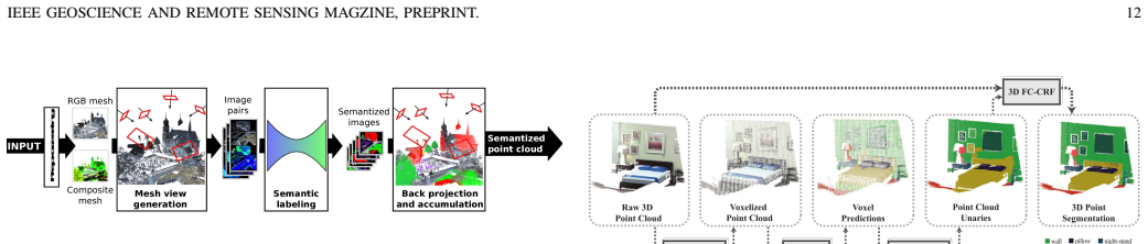
The organizing device is the taxonomy itself: point clouds are first classified by how they are acquired (image-derived, LiDAR, RGB-D, InSAR/TomoSAR), then segmentation methods are split into unsupervised PCS and supervised PCSS, and deep-learning PCSS is further split by the representation fed into the network: multiview 2D projections, voxels, or raw points. The workhorse pipeline for classical supervised PCSS is the four-stage procedure described by Weinmann et al. [95] - neighborhood selection, feature extraction, feature selection, and classification - and for deep learning the baseline is PointNet's symmetric-function architecture, which fuses per-point and global features. The review uses this machinery to position each cited method and to derive the open-issue discussion.
What would settle it
Checking the survey against a systematic search would settle it: if a literature search with explicit inclusion criteria surfaced a substantial body of pre-2019 PCSS work that fits none of the paper's categories, or a mainstream benchmark missing from its dataset list, the completeness claim would fail.
Extended reading notes
Core claim
The paper's central claim is that PCSS can be organized by a clear taxonomy, and that the main axes are data acquisition, segmentation technique, and the representation ingested by a neural network. On the data side it distinguishes image-derived, LiDAR, RGB-D, and synthetic aperture radar point clouds; on the algorithmic side it separates unsupervised PCS (edge-based, region growing, model fitting, clustering) from supervised PCSS (classical machine learning with contextual models, and deep learning in multiview, voxel, and point-based forms). It further claims that deep learning has displaced handcrafted-feature methods on public benchmarks, but that no standard public network exists and results are hard to compare across incompatible datasets. The authors conclude that the open problems center on benchmark diversity, multi-source and SAR data, noise robustness, interpretability, and evaluation metrics that reflect per-class accuracy for remote sensing.
Load-bearing premise
The review's usefulness depends on the completeness and representativeness of its chosen references, since it presents a narrative taxonomy rather than a systematic literature search with inclusion criteria.
Editorial extensions
If this is right
- A reader can use the taxonomy to translate a paper's contribution into its place in the field: any deep-learning PCSS method must choose among multiview, voxel, or point-based representations, and that choice determines its main strengths and failure modes.
- Because results are reported on incompatible datasets, the review implies that benchmark performance cannot be read across papers as a single ranking; method selection must be dataset- and application-specific.
- The survey suggests that remote sensing applications need per-class evaluation, multi-source fusion, and noise-tolerant algorithms, not just overall accuracy on dense full-3D scans.
- The open-issue section implies that the near-term research agenda is to expand annotated data to more object types and sensor modalities, especially image-derived and SAR point clouds.
- The review's treatment of SAR point clouds predicts that InSAR/TomoSAR data will become a more common substrate for PCSS as global satellite stacks become accessible.
Reading between the lines
- I infer the taxonomy can absorb later developments such as transformer- and attention-based point cloud networks within the point-based category, since it is defined by data representation, not by the specific operator.
- A testable extension suggested but not run by the paper: take one representative method per taxonomy cell and evaluate it on all four acquisition types to quantify the cross-sensor generalization gap the authors describe.
- The paper's emphasis on limited benchmark diversity points to synthetic point cloud generation and domain adaptation as natural next steps, though the review does not discuss them.
- The authors' conclusion about no standard public network implies that the field would benefit from a common evaluation harness with fixed train/test splits across all major datasets; this is my inference, not their proposal.
Signed reviews
Editorial analysis
A structured set of objections, weighed in public.
Referee Report
Summary. This manuscript is a narrative review of point cloud semantic segmentation (PCSS). It surveys point cloud acquisition techniques (image-derived, LiDAR, RGB-D, InSAR), describes existing benchmark datasets, reviews traditional point cloud segmentation methods (edge-based, region growing, model fitting, clustering, oversegmentation) and supervised PCSS methods (regular machine learning and deep learning), and closes with a discussion of open issues. The paper proposes no new algorithms and reports no experiments; its contribution is a structured, referenced map of the field as of 2019.
Significance. If taken as a qualitative survey, the paper succeeds in providing a useful and internally consistent taxonomy. Its mathematical descriptions of the Hough transform, RANSAC, and PointNet are accurate, and the inclusion of TomoSAR point clouds as a data source is a distinctive perspective that most computer vision surveys lack. The authors explicitly disclose the review's limitations (non-exhaustive dataset list, qualitative comparison, limited data sources) in Sections II-D and V, which appropriately scopes the claims. The paper makes no falsifiable predictions and includes no reproducible code, but for a magazine review this is expected. The reference list is broad and representative of the field through 2019.
minor comments (6)
- [Abstract] The abstract states that techniques are 'reviewed and compared', but Section IV-B gives a narrative description of deep learning methods without a quantitative comparison table; consider adding a short summary table with reported performance on a common benchmark (e.g., Semantic3D or S3DIS) or softening the wording to 'described and qualitatively compared'.
- [II-D] The benchmark dataset list is explicitly non-exhaustive, yet it omits recently influential LiDAR benchmarks such as SemanticKITTI (2019) and Toronto3D (2020); adding them would improve the 'up-to-date' claim for the journal version.
- [II-D-5] In the ScanNet description, the sentence 'ScanNet is a collection of labeled voxels rather than points or objects' is imprecise; ScanNet provides annotations on mesh vertices and also publishes voxelized labels, so it is more accurate to say the dataset offers vertex-level labels that can be voxelized.
- [II-C (Table II)] Table II contains several typographical errors (e.g., 'Oversegnentation' in the caption) and is very dense; consider fixing typos and expanding the abbreviations legend for readability.
- [Global] There are numerous typos and spacing artifacts throughout the text (e.g., 'resolutioan', 'Futhermore', 'benckmark', 'variabil1ity', 'unorderd', 'V oxel'), which should be corrected in the final version.
- [III-C-1] Equations (1) and (2) are correct, but the text could clarify that \rho in Eq. (1) is the perpendicular distance from the origin to the line (normal form) to avoid confusion with a generic 'distance'.
Circularity Check
No significant circularity: the review organizes external results and makes no derived predictions.
full rationale
This is a narrative review with no fitted parameters, no predictive model, and no formal derivation chain. Its central claim is to provide an up-to-date structured map of point cloud semantic segmentation (PCSS) as of 2019, and its taxonomies (PCS: edge/region/model/clustering; PCSS: regular ML vs. deep learning split into multiview/voxel/point-based, plus hybrid presegmentation) are organizational summaries of cited external works rather than conclusions derived from the authors' own definitions. The mathematical descriptions that do appear (Hough parameterization, RANSAC optimization, PointNet symmetric aggregation) are standard textbook-level statements and do not function as predictions of any new result. The authors cite several of their own TomoSAR papers ([45]-[49]) when characterizing SAR-derived point clouds, but this is normal self-citation in a review context and is not load-bearing: the survey's organization and open-issues discussion would be unchanged if those citations were replaced by independent TomoSAR references. The paper also explicitly discloses its own limitations (qualitative comparison rather than quantitative benchmarking, nonexhaustive dataset list, limited data sources for benchmarks in Sections II-D and V-C), which further indicates that no hidden circular derivation is being asserted. No step in the paper reduces by construction to an input, no fitted value is relabeled as a prediction, and no self-citation chain forces the survey's conclusions. The score is therefore 0.
Assumptions & free parameters
assumptions (3)
- domain assumption Point clouds are unordered and unstructured, so standard 2D convolutions cannot be directly applied.
- domain assumption Segmentation methods can be partitioned into edge-based, region growing, model fitting, and clustering families.
- domain assumption The selected benchmark datasets are representative of the state of PCSS.
Cite this review
Pith. "Pith review of Linking Points With Labels in 3D: A Review of Point Cloud Semantic Segmentation." pith.science (2026). https://pith.science/paper/2WB5CHUK
@misc{pith2026190808854,
  author       = {Pith},
  title        = {Pith review of: Linking Points With Labels in 3D: A Review of Point Cloud Semantic Segmentation},
  year         = {2026},
  howpublished = {\url{https://pith.science/paper/2WB5CHUK}},
  note         = {Machine review of arXiv:1908.08854}
}
read the original abstract
3D Point Cloud Semantic Segmentation (PCSS) is attracting increasing interest, due to its applicability in remote sensing, computer vision and robotics, and due to the new possibilities offered by deep learning techniques. In order to provide a needed up-to-date review of recent developments in PCSS, this article summarizes existing studies on this topic. Firstly, we outline the acquisition and evolution of the 3D point cloud from the perspective of remote sensing and computer vision, as well as the published benchmarks for PCSS studies. Then, traditional and advanced techniques used for Point Cloud Segmentation (PCS) and PCSS are reviewed and compared. Finally, important issues and open questions in PCSS studies are discussed.
Figures


Figures from the paper (3 more)


Reference graph
Works this paper leans on
-
[1]
Pointnet: Deep learning on point sets for 3d classification and segmentation,
C. R. Qi, H. Su, K. Mo, and L. J. Guibas, “Pointnet: Deep learning on point sets for 3d classification and segmentation,” in Proceedings of the IEEE Conference on Computer Vision and Pattern Recognition , pp. 652–660, 2017
2017
-
[2]
Large-scale point cloud semantic segmentation with superpoint graphs,
L. Landrieu and M. Simonovsky, “Large-scale point cloud semantic segmentation with superpoint graphs,” in Proceedings of the IEEE Conference on Computer Vision and Pattern Recognition , pp. 4558– 4567, 2018
2018
-
[3]
Dynamic graph cnn for learning on point clouds,
Y . Wang, Y . Sun, Z. Liu, S. E. Sarma, M. M. Bronstein, and J. M. Solomon, “Dynamic graph cnn for learning on point clouds,” arXiv preprint arXiv:1801.07829, 2018. IEEE GEOSCIENCE AND REMOTE SENSING MAGZINE, PREPRINT. 16
arXiv 2018
-
[4]
Svm-based classification of segmented airborne lidar point clouds in urban areas,
J. Zhang, X. Lin, and X. Ning, “Svm-based classification of segmented airborne lidar point clouds in urban areas,” Remote Sensing , vol. 5, no. 8, pp. 3749–3775, 2013
2013
-
[5]
Contextual classification of point cloud data by exploiting individual 3d neigbourhoods,
M. Weinmann, A. Schmidt, C. Mallet, S. Hinz, F. Rottensteiner, and B. Jutzi, “Contextual classification of point cloud data by exploiting individual 3d neigbourhoods,” ISPRS Annals of the Photogrammetry, Remote Sensing and Spatial Information Sciences II-3 (2015), Nr. W4 , vol. 2, no. W4, pp. 271–278, 2015
2015
-
[6]
A multiscale and hierarchical feature extraction method for terrestrial laser scanning point cloud classifica- tion,
Z. Wang, L. Zhang, T. Fang, P. T. Mathiopoulos, X. Tong, H. Qu, Z. Xiao, F. Li, and D. Chen, “A multiscale and hierarchical feature extraction method for terrestrial laser scanning point cloud classifica- tion,” IEEE Transactions on Geoscience and Remote Sensing , vol. 53, no. 5, pp. 2409–2425, 2015
2015
-
[7]
Semantic labeling of 3d point clouds for indoor scenes,
H. S. Koppula, A. Anand, T. Joachims, and A. Saxena, “Semantic labeling of 3d point clouds for indoor scenes,” in Advances in neural information processing systems , pp. 244–252, 2011
2011
-
[8]
Simplified markov random fields for efficient semantic labeling of 3d point clouds,
Y . Lu and C. Rasmussen, “Simplified markov random fields for efficient semantic labeling of 3d point clouds,” in 2012 IEEE/RSJ International Conference on Intelligent Robots and Systems , pp. 2690–2697, IEEE, 2012
2012
Show all 195 references
-
[9]
Unstructured point cloud semantic labeling using deep segmentation networks.,
A. Boulch, B. Le Saux, and N. Audebert, “Unstructured point cloud semantic labeling using deep segmentation networks.,” in 3DOR, 2017
2017
-
[10]
Automatic reconstruction of as-built building information models from laser- scanned point clouds: A review of related techniques,
P. Tang, D. Huber, B. Akinci, R. Lipman, and A. Lytle, “Automatic reconstruction of as-built building information models from laser- scanned point clouds: A review of related techniques,” Automation in construction, vol. 19, no. 7, pp. 829–843, 2010
2010
-
[11]
Building information mod- eling (bim) for existing buildingsliterature review and future needs,
R. V olk, J. Stengel, and F. Schultmann, “Building information mod- eling (bim) for existing buildingsliterature review and future needs,” Automation in construction , vol. 38, pp. 109–127, 2014
2014
-
[12]
Lidar remote sensing of forest structure,
K. Lim, P. Treitz, M. Wulder, B. St-Onge, and M. Flood, “Lidar remote sensing of forest structure,” Progress in physical geography , vol. 27, no. 1, pp. 88–106, 2003
2003
-
[13]
Development of a uav-lidar system with application to forest inventory,
L. Wallace, A. Lucieer, C. Watson, and D. Turner, “Development of a uav-lidar system with application to forest inventory,” Remote Sensing, vol. 4, no. 6, pp. 1519–1543, 2012
2012
-
[14]
To- wards 3d point cloud based object maps for household environments,
R. B. Rusu, Z. C. Marton, N. Blodow, M. Dolha, and M. Beetz, “To- wards 3d point cloud based object maps for household environments,” Robotics and Autonomous Systems, vol. 56, no. 11, pp. 927–941, 2008
2008
-
[15]
Multi-view 3d object detection network for autonomous driving,
X. Chen, H. Ma, J. Wan, B. Li, and T. Xia, “Multi-view 3d object detection network for autonomous driving,” in Proceedings of the IEEE Conference on Computer Vision and Pattern Recognition , pp. 1907– 1915, 2017
1907
-
[16]
3d point cloud segmentation: A survey,
A. Nguyen and B. Le, “3d point cloud segmentation: A survey,” in 2013 6th IEEE conference on robotics, automation and mechatronics (RAM), pp. 225–230, IEEE, 2013
2013
-
[17]
A review of point clouds seg- mentation and classification algorithms,
E. Grilli, F. Menna, and F. Remondino, “A review of point clouds seg- mentation and classification algorithms,” in The International Archives of Photogrammetry, Remote Sensing and Spatial Information Sciences , vol. 42, p. 339, 2017
2017
-
[18]
A comparison between photogrammetry and laser scanning,
E. P. Baltsavias, “A comparison between photogrammetry and laser scanning,” ISPRS Journal of photogrammetry and Remote Sensing , vol. 54, no. 2-3, pp. 83–94, 1999
1999
-
[19]
structure-from-motionphotogrammetry: A low-cost, ef- fective tool for geoscience applications,
M. J. Westoby, J. Brasington, N. F. Glasser, M. J. Hambrey, and J. Reynolds, “structure-from-motionphotogrammetry: A low-cost, ef- fective tool for geoscience applications,” Geomorphology, vol. 179, pp. 300–314, 2012
2012
-
[20]
Introduction to modern photogrammetry,
E. M. Mikhail, J. S. Bethel, and J. C. McGlone, “Introduction to modern photogrammetry,” New York, 2001
2001
-
[21]
Accurate and efficient stereo processing by semi- global matching and mutual information,
H. Hirschm ¨uller, “Accurate and efficient stereo processing by semi- global matching and mutual information,” in Proceedings of the IEEE Conference on Computer Vision and Pattern Recognition, pp. 807–814, 2005
2005
-
[22]
Stereo processing by semiglobal matching and mu- tual information,
H. Hirschm ¨uller, “Stereo processing by semiglobal matching and mu- tual information,” IEEE Transactions on pattern analysis and machine intelligence, vol. 30, no. 2, pp. 328–341, 2008
2008
-
[23]
Evaluation of cost functions for stereo matching,
H. Hirschm ¨uller and D. Scharstein, “Evaluation of cost functions for stereo matching,” in 2007 IEEE Conference on Computer Vision and Pattern Recognition, pp. 1–8, IEEE, 2007
2007
-
[24]
Accurate, dense, and robust multiview stereopsis,
Y . Furukawa and J. Ponce, “Accurate, dense, and robust multiview stereopsis,” IEEE transactions on pattern analysis and machine intel- ligence, vol. 32, no. 8, pp. 1362–1376, 2010
2010
-
[25]
Uav for 3d mapping applications: a review,
F. Nex and F. Remondino, “Uav for 3d mapping applications: a review,” Applied geomatics, vol. 6, no. 1, pp. 1–15, 2014
2014
-
[26]
Photo tourism: exploring photo collections in 3d,
N. Snavely, S. M. Seitz, and R. Szeliski, “Photo tourism: exploring photo collections in 3d,” in ACM transactions on graphics (TOG) , vol. 25, pp. 835–846, ACM, 2006
2006
-
[27]
Modeling the world from internet photo collections,
N. Snavely, S. M. Seitz, and R. Szeliski, “Modeling the world from internet photo collections,” International journal of computer vision , vol. 80, no. 2, pp. 189–210, 2008
2008
-
[28]
Sun3d: A database of big spaces reconstructed using sfm and object labels,
J. Xiao, A. Owens, and A. Torralba, “Sun3d: A database of big spaces reconstructed using sfm and object labels,” in Proceedings of the IEEE International Conference on Computer Vision , pp. 1625–1632, 2013
2013
-
[29]
Shan and C
J. Shan and C. K. Toth, Topographic laser ranging and scanning: principles and processing . CRC press, 2018
2018
-
[30]
3d change detection–approaches and applications,
R. Qin, J. Tian, and P. Reinartz, “3d change detection–approaches and applications,” ISPRS Journal of Photogrammetry and Remote Sensing , vol. 122, pp. 41–56, 2016
2016
-
[31]
Isprs test project on urban classification and 3d building reconstruction,
F. Rottensteiner, G. Sohn, M. Gerke, and J. D. Wegner, “Isprs test project on urban classification and 3d building reconstruction,” Com- mission III-Photogrammetric Computer Vision and Image Analysis, Working Group III/4-3D Scene Analysis , pp. 1–17, 2013
2013
-
[32]
Assessing forest structural and physiological information content of multi-spectral lidar waveforms by radiative transfer modelling,
F. Morsdorf, C. Nichol, T. Malthus, and I. H. Woodhouse, “Assessing forest structural and physiological information content of multi-spectral lidar waveforms by radiative transfer modelling,” Remote Sensing of Environment, vol. 113, no. 10, pp. 2152–2163, 2009
2009
-
[33]
Recovery of forest canopy parameters by inversion of multispectral lidar data,
A. Wallace, C. Nichol, and I. Woodhouse, “Recovery of forest canopy parameters by inversion of multispectral lidar data,” Remote Sensing , vol. 4, no. 2, pp. 509–531, 2012
2012
-
[34]
Semantic3d. net: a new large-scale point cloud classifi- cation benchmark,
T. Hackel, N. Savinov, L. Ladicky, J. Wegner, K. Schindler, and M. Pollefeys, “Semantic3d. net: a new large-scale point cloud classifi- cation benchmark,” ISPRS Annals of Photogrammetry, Remote Sensing and Spatial Information Sciences , pp. 91–98, 2017
2017
-
[35]
Terramobilita/iqmulus urban point cloud classification benchmark,
M. Br ´edif, B. Vallet, A. Serna, B. Marcotegui, and N. Paparoditis, “Terramobilita/iqmulus urban point cloud classification benchmark,” in Workshop on Processing Large Geospatial Data , 2014
2014
-
[36]
Paris-lille-3d: A large and high-quality ground-truth urban point cloud dataset for automatic segmentation and classification,
X. Roynard, J.-E. Deschaud, and F. Goulette, “Paris-lille-3d: A large and high-quality ground-truth urban point cloud dataset for automatic segmentation and classification,” The International Journal of Robotics Research, vol. 37, no. 6, pp. 545–557, 2018
2018
-
[37]
Uav lidar and hyperspectral fusion for forest monitoring in the southwestern usa,
T. Sankey, J. Donager, J. McVay, and J. B. Sankey, “Uav lidar and hyperspectral fusion for forest monitoring in the southwestern usa,” Remote Sensing of Environment , vol. 195, pp. 30–43, 2017
2017
-
[38]
An automated rectification method for unmanned aerial vehicle lidar point cloud data based on laser intensity,
X. Zhang, R. Gao, Q. Sun, and J. Cheng, “An automated rectification method for unmanned aerial vehicle lidar point cloud data based on laser intensity,” Remote Sensing, vol. 11, no. 7, p. 811, 2019
2019
-
[39]
3d forest mapping using a low-cost uav laser scanning system: Investigation and comparison,
J. Li, B. Yang, Y . Cong, L. Cao, X. Fu, and Z. Dong, “3d forest mapping using a low-cost uav laser scanning system: Investigation and comparison,” Remote Sensing, vol. 11, no. 6, p. 717, 2019
2019
-
[40]
Enhanced computer vision with microsoft kinect sensor: A review,
J. Han, L. Shao, D. Xu, and J. Shotton, “Enhanced computer vision with microsoft kinect sensor: A review,” IEEE transactions on cybernetics , vol. 43, no. 5, pp. 1318–1334, 2013
2013
-
[41]
A passive rgbd sensor for accurate and real-time depth sensing self-contained into an fpga,
S. Mattoccia and M. Poggi, “A passive rgbd sensor for accurate and real-time depth sensing self-contained into an fpga,” in Proceedings of the 9th International Conference on Distributed Smart Cameras , pp. 146–151, ACM, 2015
2015
-
[42]
First experiences with kinect v2 sensor for close range 3d modelling,
E. Lachat, H. Macher, M. Mittet, T. Landes, and P. Grussenmeyer, “First experiences with kinect v2 sensor for close range 3d modelling,” in The International Archives of Photogrammetry, Remote Sensing and Spatial Information Sciences , vol. 40, p. 93, 2015
2015
-
[43]
Scannet: Richly-annotated 3d reconstructions of indoor scenes,
A. Dai, A. X. Chang, M. Savva, M. Halber, T. Funkhouser, and M. Nießner, “Scannet: Richly-annotated 3d reconstructions of indoor scenes,” in Proceedings of the IEEE Conference on Computer Vision and Pattern Recognition, pp. 5828–5839, 2017
2017
-
[44]
3d semantic parsing of large-scale indoor spaces,
I. Armeni, O. Sener, A. R. Zamir, H. Jiang, I. Brilakis, M. Fischer, and S. Savarese, “3d semantic parsing of large-scale indoor spaces,” in Proceedings of the IEEE Conference on Computer Vision and Pattern Recognition, pp. 1534–1543, 2016
2016
-
[45]
Facade structure recon- struction using spaceborne tomosar point clouds,
M. Shahzad, X. X. Zhu, and R. Bamler, “Facade structure recon- struction using spaceborne tomosar point clouds,” in 2012 IEEE International Geoscience and Remote Sensing Symposium , pp. 467– 470, IEEE, 2012
2012
-
[46]
Facade reconstruction using multiview spaceborne tomosar point clouds,
X. X. Zhu and M. Shahzad, “Facade reconstruction using multiview spaceborne tomosar point clouds,” IEEE Transactions on Geoscience and Remote Sensing , vol. 52, no. 6, pp. 3541–3552, 2014
2014
-
[47]
Robust reconstruction of building facades for large areas using spaceborne tomosar point clouds,
M. Shahzad and X. X. Zhu, “Robust reconstruction of building facades for large areas using spaceborne tomosar point clouds,” IEEE Transac- tions on Geoscience and Remote Sensing , vol. 53, no. 2, pp. 752–769, 2015
2015
-
[48]
Segmentation and crown parameter extraction of individual trees in an airborne tomosar point cloud,
M. Shahzad, M. Schmitt, and X. X. Zhu, “Segmentation and crown parameter extraction of individual trees in an airborne tomosar point cloud,” in International Archives of Photogrammetry, Remote Sensing and Spatial Information Sciences , vol. 40, pp. 205–209, 2015. IEEE GEOSCIEN...
2015
-
[49]
Reconstruction of individual trees from multi-aspect tomosar data,
M. Schmitt, M. Shahzad, and X. X. Zhu, “Reconstruction of individual trees from multi-aspect tomosar data,” Remote Sensing of Environment, vol. 165, pp. 175–185, 2015
2015
-
[50]
Interferometric potential of high resolution spaceborne sar,
R. Bamler, M. Eineder, N. Adam, X. X. Zhu, and S. Gern- hardt, “Interferometric potential of high resolution spaceborne sar,” Photogrammetrie-Fernerkundung-Geoinformation, vol. 2009, no. 5, pp. 407–419, 2009
2009
-
[51]
Very high resolution spaceborne sar tomography in urban environment,
X. X. Zhu and R. Bamler, “Very high resolution spaceborne sar tomography in urban environment,” IEEE Transactions on Geoscience and Remote Sensing , vol. 48, no. 12, pp. 4296–4308, 2010
2010
-
[52]
Potential of very high resolution sar for persistent scatterer interferometry in urban areas,
S. Gernhardt, N. Adam, M. Eineder, and R. Bamler, “Potential of very high resolution sar for persistent scatterer interferometry in urban areas,” Annals of GIS , vol. 16, no. 2, pp. 103–111, 2010
2010
-
[53]
Geo- metrical fusion of multitrack ps point clouds,
S. Gernhardt, X. Cong, M. Eineder, S. Hinz, and R. Bamler, “Geo- metrical fusion of multitrack ps point clouds,” IEEE Geoscience and Remote Sensing Letters , vol. 9, no. 1, pp. 38–42, 2012
2012
-
[54]
Super-resolution power and robustness of compressive sensing for spectral estimation with application to spaceborne tomographic sar,
X. X. Zhu and R. Bamler, “Super-resolution power and robustness of compressive sensing for spectral estimation with application to spaceborne tomographic sar,” IEEE Transactions on Geoscience and Remote Sensing, vol. 50, no. 1, pp. 247–258, 2012
2012
-
[55]
Geocoding error correction for insar point clouds,
S. Montazeri, F. Rodr ´ıguez Gonz´alez, and X. X. Zhu, “Geocoding error correction for insar point clouds,” Remote Sensing , vol. 10, no. 10, p. 1523, 2018
2018
-
[56]
A new method for building extrac- tion in urban areas from high-resolution lidar data,
F. Rottensteiner and C. Briese, “A new method for building extrac- tion in urban areas from high-resolution lidar data,” in International Archives of Photogrammetry Remote Sensing and Spatial Information Sciences, vol. 34, pp. 295–301, 2002
2002
-
[57]
Demonstration of super-resolution for tomographic sar imaging in urban environment,
X. X. Zhu and R. Bamler, “Demonstration of super-resolution for tomographic sar imaging in urban environment,” IEEE Transactions on Geoscience and Remote Sensing , vol. 50, no. 8, pp. 3150–3157, 2012
2012
-
[58]
From tomosar point clouds to objects: Facade reconstruction,
X. X. Zhu, M. Shahzad, and R. Bamler, “From tomosar point clouds to objects: Facade reconstruction,” in 2012 Tyrrhenian Workshop on Advances in Radar and Remote Sensing (TyWRRS), pp. 106–113, IEEE, 2012
2012
-
[59]
Let’s do the time warp: Multicomponent nonlinear motion estimation in differential sar tomography,
X. X. Zhu and R. Bamler, “Let’s do the time warp: Multicomponent nonlinear motion estimation in differential sar tomography,” IEEE Geoscience and Remote Sensing Letters , vol. 8, no. 4, pp. 735–739, 2011
2011
-
[60]
Ghost persistent scatterers related to multiple signal reflections,
S. Auer, S. Gernhardt, and R. Bamler, “Ghost persistent scatterers related to multiple signal reflections,” IEEE Geoscience and Remote Sensing Letters, vol. 8, no. 5, pp. 919–923, 2011
2011
-
[61]
Nonlocal compressive sensing- based sar tomography,
Y . Shi, X. X. Zhu, and R. Bamler, “Nonlocal compressive sensing- based sar tomography,” IEEE Transactions on Geoscience and Remote Sensing, vol. 57, no. 5, pp. 3015–3024, 2019
2019
-
[62]
Automatic feature-based geometric fusion of multiview tomosar point clouds in urban area,
Y . Wang and X. X. Zhu, “Automatic feature-based geometric fusion of multiview tomosar point clouds in urban area,” IEEE Journal of Selected Topics in Applied Earth Observations and Remote Sensing , vol. 8, no. 3, pp. 953–965, 2014
2014
-
[63]
Data fusion and remote sensing: An ever-growing relationship,
M. Schmitt and X. X. Zhu, “Data fusion and remote sensing: An ever-growing relationship,” IEEE Geoscience and Remote Sensing Magazine, vol. 4, no. 4, pp. 6–23, 2016
2016
-
[64]
Fusing meter- resolution 4-d insar point clouds and optical images for semantic urban infrastructure monitoring,
Y . Wang, X. X. Zhu, B. Zeisl, and M. Pollefeys, “Fusing meter- resolution 4-d insar point clouds and optical images for semantic urban infrastructure monitoring,” IEEE Transactions on Geoscience and Remote Sensing , vol. 55, no. 1, pp. 14–26, 2017
2017
-
[65]
H- ransac: A hybrid point cloud segmentation combining 2d and 3d data.,
A. Adam, E. Chatzilari, S. Nikolopoulos, and I. Kompatsiaris, “H- ransac: A hybrid point cloud segmentation combining 2d and 3d data.,” ISPRS Annals of Photogrammetry, Remote Sensing & Spatial Information Sciences, vol. 4, no. 2, 2018
2018
-
[66]
Segmen- tation of building from dense 3d point-clouds,
J. Bauer, K. Karner, K. Schindler, A. Klaus, and C. Zach, “Segmen- tation of building from dense 3d point-clouds,” in Proceedings of the ISPRS. Workshop Laser scanning Enschede , pp. 12–14, 2005
2005
-
[67]
Snapnet: 3d point cloud semantic labeling with 2d deep segmentation networks,
A. Boulch, J. Guerry, B. Le Saux, and N. Audebert, “Snapnet: 3d point cloud semantic labeling with 2d deep segmentation networks,” Computers & Graphics , vol. 71, pp. 189–198, 2018
2018
-
[68]
Splatnet: Sparse lattice networks for point cloud processing,
H. Su, V . Jampani, D. Sun, S. Maji, E. Kalogerakis, M.-H. Yang, and J. Kautz, “Splatnet: Sparse lattice networks for point cloud processing,” in Proceedings of the IEEE Conference on Computer Vision and Pattern Recognition, pp. 2530–2539, 2018
2018
-
[69]
Octnet: Learning deep 3d representations at high resolutions,
G. Riegler, A. Osman Ulusoy, and A. Geiger, “Octnet: Learning deep 3d representations at high resolutions,” in Proceedings of the IEEE Conference on Computer Vision and Pattern Recognition , pp. 3577– 3586, 2017
2017
-
[70]
4d spatio-temporal convnets: Minkowski convolutional neural networks,
C. Choy, J. Gwak, and S. Savarese, “4d spatio-temporal convnets: Minkowski convolutional neural networks,” inProceedings of the IEEE Conference on Computer Vision and Pattern Recognition , pp. 3075– 3084, 2019
2019
-
[71]
Real-time detection of planar regions in unorganized point clouds,
F. A. Limberger and M. M. Oliveira, “Real-time detection of planar regions in unorganized point clouds,” Pattern Recognition , vol. 48, no. 6, pp. 2043–2053, 2015
2015
-
[72]
Investigation on the weighted ransac approaches for building roof plane segmentation from lidar point clouds,
B. Xu, W. Jiang, J. Shan, J. Zhang, and L. Li, “Investigation on the weighted ransac approaches for building roof plane segmentation from lidar point clouds,” Remote Sensing, vol. 8, no. 1, p. 5, 2015
2015
-
[73]
A methodology for automated segmentation and reconstruction of urban 3-d buildings from als point clouds,
D. Chen, L. Zhang, P. T. Mathiopoulos, and X. Huang, “A methodology for automated segmentation and reconstruction of urban 3-d buildings from als point clouds,” IEEE Journal of Selected Topics in Applied Earth Observations and Remote Sensing , vol. 7, no. 10, pp. 4199– 4217, 2014
2014
-
[74]
Hough-transform and extended ransac algorithms for automatic detection of 3d building roof planes from lidar data,
F. Tarsha-Kurdi, T. Landes, and P. Grussenmeyer, “Hough-transform and extended ransac algorithms for automatic detection of 3d building roof planes from lidar data,” in ISPRS Workshop on Laser Scanning 2007 and SilviLaser 2007 , vol. 36, pp. 407–412, 2007
2007
-
[75]
Segmentation of tin-structured surface models,
B. Gorte, “Segmentation of tin-structured surface models,” in Inter- national Archives of Photogrammetry Remote Sensing and Spatial Information Sciences, vol. 34, pp. 465–469, 2002
2002
-
[76]
Clustering based planar roof extraction from lidar data,
A. Sampath and J. Shan, “Clustering based planar roof extraction from lidar data,” in American Society for Photogrammetry and Remote Sensing Annual Conference, Reno, Nevada, May , pp. 1–6, 2006
2006
-
[77]
Segmentation and reconstruction of polyhe- dral building roofs from aerial lidar point clouds,
A. Sampath and J. Shan, “Segmentation and reconstruction of polyhe- dral building roofs from aerial lidar point clouds,” IEEE Transactions on geoscience and remote sensing, vol. 48, no. 3, pp. 1554–1567, 2010
2010
-
[78]
Min-cut based segmentation of airborne lidar point clouds,
S. Ural and J. Shan, “Min-cut based segmentation of airborne lidar point clouds,” inInternational Archives of the Photogrammetry, Remote Sensing and Spatial Information Sciences , pp. 167–172, 2012
2012
-
[79]
A global optimization approach to roof segmentation from airborne lidar point clouds,
J. Yan, J. Shan, and W. Jiang, “A global optimization approach to roof segmentation from airborne lidar point clouds,” ISPRS journal of photogrammetry and remote sensing , vol. 94, pp. 183–193, 2014
2014
-
[80]
Non-parametric segmentation of als point clouds using mean shift,
T. Melzer, “Non-parametric segmentation of als point clouds using mean shift,” Journal of Applied Geodesy Jag , vol. 1, no. 3, pp. 159– 170, 2007
2007
-
[81]
Object extraction based on 3d- segmentation of lidar data by combining mean shift with normalized cuts: Two examples from urban areas,
W. Yao, S. Hinz, and U. Stilla, “Object extraction based on 3d- segmentation of lidar data by combining mean shift with normalized cuts: Two examples from urban areas,” in 2009 Joint Urban Remote Sensing Event, pp. 1–6, IEEE, 2009
2009
-
[82]
Aerial lidar data classification using adaboost,
S. K. Lodha, D. M. Fitzpatrick, and D. P. Helmbold, “Aerial lidar data classification using adaboost,” in Sixth International Conference on 3- D Digital Imaging and Modeling (3DIM 2007) , pp. 435–442, IEEE, 2007
2007
-
[83]
Classifying urban landscape in aerial lidar using 3d shape analysis,
M. Carlberg, P. Gao, G. Chen, and A. Zakhor, “Classifying urban landscape in aerial lidar using 3d shape analysis,” in 2009 16th IEEE International Conference on Image Processing (ICIP) , pp. 1701–1704, IEEE, 2009
2009
-
[84]
Airborne lidar feature selection for urban classification using random forests,
N. Chehata, L. Guo, and C. Mallet, “Airborne lidar feature selection for urban classification using random forests,” in International Archives of Photogrammetry, Remote Sensing and Spatial Information Sciences , vol. 38, pp. 207–212, 2009
2009
-
[85]
Nonassociative markov networks for 3d point cloud classification,
R. Shapovalov, E. Velizhev, and O. Barinova, “Nonassociative markov networks for 3d point cloud classification,” in International Archives of the Photogrammetry, Remote Sensing and Spatial Information Sciences, vol. 38, pp. 103–108, 2010
2010
-
[86]
Conditional random fields for lidar point cloud classification in complex urban areas,
J. Niemeyer, F. Rottensteiner, and U. Soergel, “Conditional random fields for lidar point cloud classification in complex urban areas,” in ISPRS annals of the photogrammetry, remote sensing and spatial information sciences, vol. 3, pp. 263–268, 2012
2012
-
[87]
Contextual classification of lidar data and building object detection in urban areas,
J. Niemeyer, F. Rottensteiner, and U. Soergel, “Contextual classification of lidar data and building object detection in urban areas,” ISPRS journal of photogrammetry and remote sensing , vol. 87, pp. 152–165, 2014
2014
-
[88]
Contextual segment- based classification of airborne laser scanner data,
G. V osselman, M. Coenen, and F. Rottensteiner, “Contextual segment- based classification of airborne laser scanner data,” ISPRS journal of photogrammetry and remote sensing , vol. 128, pp. 354–371, 2017
2017
-
[89]
3-d scene analysis via sequenced predictions over points and regions,
X. Xiong, D. Munoz, J. A. Bagnell, and M. Hebert, “3-d scene analysis via sequenced predictions over points and regions,” in 2011 IEEE International Conference on Robotics and Automation, pp. 2609–2616, IEEE, 2011
2011
-
[90]
Non- associative higher-order markov networks for point cloud classifica- tion,
M. Najafi, S. T. Namin, M. Salzmann, and L. Petersson, “Non- associative higher-order markov networks for point cloud classifica- tion,” in European Conference on Computer Vision , pp. 500–515, Springer, 2014
2014
-
[91]
Morsdorf, E
F. Morsdorf, E. Meier, B. K ¨otz, K. I. Itten, M. Dobbertin, and B. Allg ¨ower, “Lidar-based geometric reconstruction of boreal type for- IEEE GEOSCIENCE AND REMOTE SENSING MAGZINE, PREPRINT. 18 est stands at single tree level for forest and wildland fire management,” Remote Se...
2004
-
[92]
3d segmentation of forest structure using a mean-shift based algorithm,
A. Ferraz, F. Bretar, S. Jacquemoud, G. Gonc ¸alves, and L. Pereira, “3d segmentation of forest structure using a mean-shift based algorithm,” in 2010 IEEE International Conference on Image Processing , pp. 1413– 1416, IEEE, 2010
2010
-
[93]
Octree- based region growing for point cloud segmentation,
A.-V . V o, L. Truong-Hong, D. F. Laefer, and M. Bertolotto, “Octree- based region growing for point cloud segmentation,” ISPRS Journal of Photogrammetry and Remote Sensing , vol. 104, pp. 88–100, 2015
2015
-
[94]
Robust segmentation in laser scanning 3d point cloud data,
A. Nurunnabi, D. Belton, and G. West, “Robust segmentation in laser scanning 3d point cloud data,” in 2012 International Conference on Digital Image Computing Techniques and Applications (DICTA), pp. 1– 8, IEEE, 2012
2012
-
[95]
Semantic point cloud interpretation based on optimal neighborhoods, relevant features and efficient classifiers,
M. Weinmann, B. Jutzi, S. Hinz, and C. Mallet, “Semantic point cloud interpretation based on optimal neighborhoods, relevant features and efficient classifiers,” ISPRS Journal of Photogrammetry and Remote Sensing, vol. 105, pp. 286–304, 2015
2015
-
[96]
Contex- tual classification with functional max-margin markov networks,
D. Munoz, J. A. Bagnell, N. Vandapel, and M. Hebert, “Contex- tual classification with functional max-margin markov networks,” in 2009 IEEE Conference on Computer Vision and Pattern Recognition , pp. 975–982, IEEE, 2009
2009
-
[97]
A structured regularization framework for spatially smoothing semantic labelings of 3d point clouds,
L. Landrieu, H. Raguet, B. Vallet, C. Mallet, and M. Weinmann, “A structured regularization framework for spatially smoothing semantic labelings of 3d point clouds,” ISPRS Journal of Photogrammetry and Remote Sensing, vol. 132, pp. 102–118, 2017
2017
-
[98]
Segcloud: Semantic segmentation of 3d point clouds,
L. Tchapmi, C. Choy, I. Armeni, J. Gwak, and S. Savarese, “Segcloud: Semantic segmentation of 3d point clouds,” in 2017 International Conference on 3D Vision (3DV) , pp. 537–547, IEEE, 2017
2017
-
[99]
3d recurrent neural networks with context fusion for point cloud semantic segmentation,
X. Ye, J. Li, H. Huang, L. Du, and X. Zhang, “3d recurrent neural networks with context fusion for point cloud semantic segmentation,” in Proceedings of the European Conference on Computer Vision (ECCV) , pp. 403–417, 2018
2018
-
[100]
Point cloud oversegmentation with graph-structured deep metric learning,
L. Landrieu and M. Boussaha, “Point cloud oversegmentation with graph-structured deep metric learning,” in Proceedings of the IEEE Conference on Computer Vision and Pattern Recognition , pp. 7440– 7449, 2019
2019
-
[101]
Three- dimensional point cloud plane segmentation in both structured and un- structured environments,
J. Xiao, J. Zhang, B. Adler, H. Zhang, and J. Zhang, “Three- dimensional point cloud plane segmentation in both structured and un- structured environments,” Robotics and Autonomous Systems , vol. 61, no. 12, pp. 1641–1652, 2013
2013
-
[102]
An improved ransac for 3d point cloud plane segmentation based on normal distribution transformation cells,
L. Li, F. Yang, H. Zhu, D. Li, Y . Li, and L. Tang, “An improved ransac for 3d point cloud plane segmentation based on normal distribution transformation cells,” Remote Sensing, vol. 9, no. 5, p. 433, 2017
2017
-
[103]
Automatic segmentation of building facades using terrestrial laser data,
H. Boulaassal, T. Landes, P. Grussenmeyer, and F. Tarsha-Kurdi, “Automatic segmentation of building facades using terrestrial laser data,” inISPRS Workshop on Laser Scanning 2007 and SilviLaser 2007, pp. 65–70, 2007
2007
-
[104]
An efficient global energy op- timization approach for robust 3d plane segmentation of point clouds,
Z. Dong, B. Yang, P. Hu, and S. Scherer, “An efficient global energy op- timization approach for robust 3d plane segmentation of point clouds,” ISPRS Journal of Photogrammetry and Remote Sensing , vol. 137, pp. 112–133, 2018
2018
-
[105]
Unsupervised robust planar segmenta- tion of terrestrial laser scanner point clouds based on fuzzy clustering methods,
J. M. Biosca and J. L. Lerma, “Unsupervised robust planar segmenta- tion of terrestrial laser scanner point clouds based on fuzzy clustering methods,” ISPRS Journal of Photogrammetry and Remote Sensing , vol. 63, no. 1, pp. 84–98, 2008
2008
-
[106]
Segmentation of architecture shape information from 3d point cloud,
X. Ning, X. Zhang, Y . Wang, and M. Jaeger, “Segmentation of architecture shape information from 3d point cloud,” in Proceedings of the 8th International Conference on Virtual Reality Continuum and its Applications in Industry , pp. 127–132, ACM, 2009
2009
-
[107]
Segmentation of 3d outdoor scenes using hierarchical clustering structure and perceptual grouping laws,
Y . Xu, S. Tuttas, and U. Stilla, “Segmentation of 3d outdoor scenes using hierarchical clustering structure and perceptual grouping laws,” in 2016 9th IAPR Workshop on Pattern Recogniton in Remote Sensing (PRRS), pp. 1–6, IEEE, 2016
2016
-
[108]
V oxel-and graph-based point cloud segmentation of 3d scenes using perceptual grouping laws,
Y . Xu, L. Hoegner, S. Tuttas, and U. Stilla, “V oxel-and graph-based point cloud segmentation of 3d scenes using perceptual grouping laws,” in ISPRS Annals of Photogrammetry, Remote Sensing & Spatial Information Sciences, vol. 4, 2017
2017
-
[109]
Unsupervised segmentation of point clouds from buildings using hierarchical clus- tering based on gestalt principles,
Y . Xu, W. Yao, S. Tuttas, L. Hoegner, and U. Stilla, “Unsupervised segmentation of point clouds from buildings using hierarchical clus- tering based on gestalt principles,” IEEE Journal of Selected Topics in Applied Earth Observations and Remote Sensing , no. 99, pp. 1–17, 2018
2018
-
[110]
3d terrestrial lidar classifications with super- voxels and multi-scale conditional random fields,
E. H. Lim and D. Suter, “3d terrestrial lidar classifications with super- voxels and multi-scale conditional random fields,” Computer-Aided Design, vol. 41, no. 10, pp. 701–710, 2009
2009
-
[111]
A three-step approach for tls point cloud classification,
Z. Li, L. Zhang, X. Tong, B. Du, Y . Wang, L. Zhang, Z. Zhang, H. Liu, J. Mei, X. Xing, et al. , “A three-step approach for tls point cloud classification,” IEEE Transactions on Geoscience and Remote Sensing , vol. 54, no. 9, pp. 5412–5424, 2016
2016
-
[112]
Graph attention convolution for point cloud semantic segmentation,
L. Wang, Y . Huang, Y . Hou, S. Zhang, and J. Shan, “Graph attention convolution for point cloud semantic segmentation,” in Proceedings of the IEEE Conference on Computer Vision and Pattern Recognition , pp. 10296–10305, 2019
2019
-
[113]
Scale selection for classification of point-sampled 3d surfaces,
J.-F. Lalonde, R. Unnikrishnan, N. Vandapel, and M. Hebert, “Scale selection for classification of point-sampled 3d surfaces,” in Fifth Inter- national Conference on 3-D Digital Imaging and Modeling (3DIM’05), pp. 285–292, IEEE, 2005
2005
-
[114]
The 3d hough transform for plane detection in point clouds: A review and a new accumulator design,
D. Borrmann, J. Elseberg, K. Lingemann, and A. N ¨uchter, “The 3d hough transform for plane detection in point clouds: A review and a new accumulator design,” 3D Research, vol. 2, no. 2, p. 3, 2011
2011
-
[115]
Continuous plane detection in point-cloud data based on 3d hough transform,
R. Hulik, M. Spanel, P. Smrz, and Z. Materna, “Continuous plane detection in point-cloud data based on 3d hough transform,” Journal of visual communication and image representation, vol. 25, no. 1, pp. 86– 97, 2014
2014
-
[116]
Accuracy and resolution of kinect depth data for indoor mapping applications,
K. Khoshelham and S. O. Elberink, “Accuracy and resolution of kinect depth data for indoor mapping applications,” Sensors, vol. 12, no. 2, pp. 1437–1454, 2012
2012
-
[117]
Spatial inference machines,
R. Shapovalov, D. Vetrov, and P. Kohli, “Spatial inference machines,” in Proceedings of the IEEE conference on computer vision and pattern recognition, pp. 2985–2992, 2013
2013
-
[118]
Recurrent slice networks for 3d segmentation of point clouds,
Q. Huang, W. Wang, and U. Neumann, “Recurrent slice networks for 3d segmentation of point clouds,” in Proceedings of the IEEE Conference on Computer Vision and Pattern Recognition , pp. 2626–2635, 2018
2018
-
[119]
Pointcnn: Con- volution on x-transformed points,
Y . Li, R. Bu, M. Sun, W. Wu, X. Di, and B. Chen, “Pointcnn: Con- volution on x-transformed points,” in Advances in Neural Information Processing Systems, pp. 828–838, 2018
2018
-
[120]
Pointnet++: Deep hierarchical feature learning on point sets in a metric space,
C. R. Qi, L. Yi, H. Su, and L. J. Guibas, “Pointnet++: Deep hierarchical feature learning on point sets in a metric space,” in Advances in Neural Information Processing Systems , pp. 5099–5108, 2017
2017
-
[121]
Pointsift: A sift-like network mod- ule for 3d point cloud semantic segmentation,
M. Jiang, Y . Wu, and C. Lu, “Pointsift: A sift-like network mod- ule for 3d point cloud semantic segmentation,” arXiv preprint arXiv:1807.00652, 2018
2018 arXiv
-
[122]
Pointconv: Deep convolutional networks on 3d point clouds,
W. Wu, Z. Qi, and L. Fuxin, “Pointconv: Deep convolutional networks on 3d point clouds,” in Proceedings of the IEEE Conference on Computer Vision and Pattern Recognition , pp. 9621–9630, 2019
2019
-
[123]
Associatively seg- menting instances and semantics in point clouds,
X. Wang, S. Liu, X. Shen, C. Shen, and J. Jia, “Associatively seg- menting instances and semantics in point clouds,” in Proceedings of the IEEE Conference on Computer Vision and Pattern Recognition , pp. 4096–4105, 2019
2019
-
[124]
Jsis3d: Joint semantic-instance segmentation of 3d point clouds with multi- task pointwise networks and multi-value conditional random fields,
Q.-H. Pham, T. Nguyen, B.-S. Hua, G. Roig, and S.-K. Yeung, “Jsis3d: Joint semantic-instance segmentation of 3d point clouds with multi- task pointwise networks and multi-value conditional random fields,” in Proceedings of the IEEE Conference on Computer Vision and Pattern Reco...
2019
-
[125]
A-cnn: Annularly convolutional neural networks on point clouds,
A. Komarichev, Z. Zhong, and J. Hua, “A-cnn: Annularly convolutional neural networks on point clouds,” in Proceedings of the IEEE Confer- ence on Computer Vision and Pattern Recognition , pp. 7421–7430, 2019
2019
-
[126]
Pointweb: Enhancing local neighborhood features for point cloud processing,
H. Zhao, L. Jiang, C.-W. Fu, and J. Jia, “Pointweb: Enhancing local neighborhood features for point cloud processing,” in Proceedings of the IEEE Conference on Computer Vision and Pattern Recognition , pp. 5565–5573, 2019
2019
-
[127]
Sgpn: Similarity group proposal network for 3d point cloud instance segmentation,
W. Wang, R. Yu, Q. Huang, and U. Neumann, “Sgpn: Similarity group proposal network for 3d point cloud instance segmentation,” in Proceedings of the IEEE Conference on Computer Vision and Pattern Recognition, pp. 2569–2578, 2018
2018
-
[128]
Gspn: Generative shape proposal network for 3d instance segmentation in point cloud,
L. Yi, W. Zhao, H. Wang, M. Sung, and L. J. Guibas, “Gspn: Generative shape proposal network for 3d instance segmentation in point cloud,” in Proceedings of the IEEE Conference on Computer Vision and Pattern Recognition, pp. 3947–3956, 2019
2019
-
[129]
Efficient hough transform for automatic detection of cylinders in point clouds,
T. Rabbani and F. Van Den Heuvel, “Efficient hough transform for automatic detection of cylinders in point clouds,” in International Archives of the Photogrammetry, Remote Sensing and Spatial Infor- mation Sciences, vol. 3, pp. 60–65, 2005
2005
-
[130]
Extraction of cylinders and estimation of their parameters from point clouds,
T.-T. Tran, V .-T. Cao, and D. Laurendeau, “Extraction of cylinders and estimation of their parameters from point clouds,” Computers & Graphics, vol. 46, pp. 345–357, 2015
2015
-
[131]
Acquiring qualified samples for ransac using geometrical constraints,
V .-H. Le, H. Vu, T. T. Nguyen, T.-L. Le, and T.-H. Tran, “Acquiring qualified samples for ransac using geometrical constraints,” Pattern Recognition Letters, vol. 102, pp. 58–66, 2018
2018
-
[132]
Learning where to classify in multi-view semantic segmentation,
H. Riemenschneider, A. B ´odis-Szomor´u, J. Weissenberg, and L. Van Gool, “Learning where to classify in multi-view semantic segmentation,” in European Conference on Computer Vision, pp. 516– 532, Springer, 2014. IEEE GEOSCIENCE AND REMOTE SENSING MAGZINE, PREPRINT. 19
2014
-
[133]
Unsupervised feature learning for classification of outdoor 3d scans,
M. De Deuge, A. Quadros, C. Hung, and B. Douillard, “Unsupervised feature learning for classification of outdoor 3d scans,” in Australasian Conference on Robitics and Automation , vol. 2, 2013
2013
-
[134]
Paris-rue- madame database: a 3d mobile laser scanner dataset for benchmarking urban detection, segmentation and classification methods,
A. Serna, B. Marcotegui, F. Goulette, and J.-E. Deschaud, “Paris-rue- madame database: a 3d mobile laser scanner dataset for benchmarking urban detection, segmentation and classification methods,” in 4th Inter- national Conference on Pattern Recognition, Applications and Method...
2014
-
[135]
Vision meets robotics: The kitti dataset,
A. Geiger, P. Lenz, C. Stiller, and R. Urtasun, “Vision meets robotics: The kitti dataset,” The International Journal of Robotics Research , vol. 32, no. 11, pp. 1231–1237, 2013
2013
-
[136]
Indoor segmentation and support inference from rgbd images,
N. Silberman, D. Hoiem, P. Kohli, and R. Fergus, “Indoor segmentation and support inference from rgbd images,” in European Conference on Computer Vision, pp. 746–760, Springer, 2012
2012
-
[137]
Joint 2d-3d-semantic data for indoor scene understanding,
I. Armeni, S. Sax, A. R. Zamir, and S. Savarese, “Joint 2d-3d-semantic data for indoor scene understanding,”arXiv preprint arXiv:1702.01105, 2017
2017 arXiv
-
[138]
Segmentation of point clouds using smoothness constraint,
T. Rabbani, F. Van Den Heuvel, and G. V osselmann, “Segmentation of point clouds using smoothness constraint,” in International archives of photogrammetry, remote sensing and spatial information sciences , vol. 36, pp. 248–253, 2006
2006
-
[139]
Range data processing: Representation of surfaces by edges,
B. Bhanu, S. Lee, C.-C. Ho, and T. Henderson, “Range data processing: Representation of surfaces by edges,” in Proceedings of the Eighth International Conference on Pattern Recognition , pp. 236–238, IEEE Computer Society Press, 1986
1986
-
[140]
Fast range image segmentation using high-level segmentation primitives,
X. Y . Jiang, U. Meier, and H. Bunke, “Fast range image segmentation using high-level segmentation primitives,” in Proceedings Third IEEE Workshop on Applications of Computer Vision, pp. 83–88, IEEE, 1996
1996
-
[141]
Fast range image segmentation by an edge detection strategy,
A. D. Sappa and M. Devy, “Fast range image segmentation by an edge detection strategy,” in Proceedings Third International Conference on 3-D Digital Imaging and Modeling , pp. 292–299, IEEE, 2001
2001
-
[142]
Parallel edge-region-based segmen- tation algorithm targeted at reconfigurable multiring network,
M. A. Wani and H. R. Arabnia, “Parallel edge-region-based segmen- tation algorithm targeted at reconfigurable multiring network,” The Journal of Supercomputing , vol. 25, no. 1, pp. 43–62, 2003
2003
-
[143]
Point cloud segmentation and denoising via constrained nonlinear least squares normal estimates,
E. Castillo, J. Liang, and H. Zhao, “Point cloud segmentation and denoising via constrained nonlinear least squares normal estimates,” in Innovations for Shape Analysis , pp. 283–299, Springer, 2013
2013
-
[144]
Segmentation through variable-order surface fitting,
P. J. Besl and R. C. Jain, “Segmentation through variable-order surface fitting,” IEEE Transactions on Pattern Analysis and Machine Intelli- gence, vol. 10, no. 2, pp. 167–192, 1988
1988
-
[145]
Segmentation of laser altimeter data for building reconstruction: different procedures and comparison,
R. Geibel and U. Stilla, “Segmentation of laser altimeter data for building reconstruction: different procedures and comparison,” in In- ternational Archives of Photogrammetry and Remote Sensing , vol. 33, pp. 326–334, 2000
2000
-
[146]
Segmentation based robust interpolation- a new approach to laser data filtering,
D. T ´ov´ari and N. Pfeifer, “Segmentation based robust interpolation- a new approach to laser data filtering,” in International Archives of Photogrammetry, Remote Sensing and Spatial Information Sciences , vol. 36, pp. 79–84, 2005
2005
-
[147]
A fast and accurate plane detection algorithm for large noisy point clouds using filtered normals and voxel growing,
J.-E. Deschaud and F. Goulette, “A fast and accurate plane detection algorithm for large noisy point clouds using filtered normals and voxel growing,” in 3DPVT, 2010
2010
-
[148]
Method and means for recognizing complex patterns,
P. V . Hough, “Method and means for recognizing complex patterns,”
-
[149]
A new curve detection method: randomized hough transform (rht),
L. Xu, E. Oja, and P. Kultanen, “A new curve detection method: randomized hough transform (rht),” Pattern recognition letters, vol. 11, no. 5, pp. 331–338, 1990
1990
-
[150]
Use of the hough transformation to detect lines and curves in pictures,
R. O. Duda and P. E. Hart, “Use of the hough transformation to detect lines and curves in pictures,” Communications of the ACM , vol. 15, no. 1, pp. 11–15, 1972
1972
-
[151]
A survey of simple geometric primitives detection methods for captured 3d data,
A. Kaiser, J. A. Ybanez Zepeda, and T. Boubekeur, “A survey of simple geometric primitives detection methods for captured 3d data,” in Computer Graphics Forum , vol. 38, pp. 167–196, Wiley Online Library, 2019
2019
-
[152]
A probabilistic hough transform,
N. Kiryati, Y . Eldar, and A. M. Bruckstein, “A probabilistic hough transform,” Pattern recognition, vol. 24, no. 4, pp. 303–316, 1991
1991
-
[153]
Adaptive termination of voting in the probabilistic circular hough transform,
A. Yla-Jaaski and N. Kiryati, “Adaptive termination of voting in the probabilistic circular hough transform,” IEEE Transactions on Pattern Analysis and Machine Intelligence , vol. 16, no. 9, pp. 911–915, 1994
1994
-
[154]
Progressive probabilistic hough transform for line detection,
C. Galamhos, J. Matas, and J. Kittler, “Progressive probabilistic hough transform for line detection,” in Proceedings. 1999 IEEE computer society conference on computer vision and pattern recognition , vol. 1, pp. 554–560, IEEE, 1999
1999
-
[155]
Real-time line detection through an improved hough transform voting scheme,
L. A. Fernandes and M. M. Oliveira, “Real-time line detection through an improved hough transform voting scheme,” Pattern recognition , vol. 41, no. 1, pp. 299–314, 2008
2008
-
[156]
Recognising structure in laser scanner point clouds,
G. V osselman, B. G. Gorte, G. Sithole, and T. Rabbani, “Recognising structure in laser scanner point clouds,” in International archives of photogrammetry, remote sensing and spatial information sciences , vol. 46, pp. 33–38, 2004
2004
-
[157]
3d hough transform for sphere recognition on point clouds,
M. Camurri, R. Vezzani, and R. Cucchiara, “3d hough transform for sphere recognition on point clouds,” Machine vision and applications , vol. 25, no. 7, pp. 1877–1891, 2014
2014
-
[158]
Random sample consensus: a paradigm for model fitting with applications to image analysis and automated cartography,
M. A. Fischler and R. C. Bolles, “Random sample consensus: a paradigm for model fitting with applications to image analysis and automated cartography,” Communications of the ACM , vol. 24, no. 6, pp. 381–395, 1981
1981
-
[159]
Performance evaluation of ransac family,
S. Choi, T. Kim, and W. Yu, “Performance evaluation of ransac family,” in Proceedings of the British Machine Vision Conference , 2009
2009
-
[160]
A comparative analysis of ransac techniques leading to adaptive real-time random sample consensus,
R. Raguram, J.-M. Frahm, and M. Pollefeys, “A comparative analysis of ransac techniques leading to adaptive real-time random sample consensus,” in European Conference on Computer Vision , pp. 500– 513, Springer, 2008
2008
-
[161]
Usac: a universal framework for random sample consensus,
R. Raguram, O. Chum, M. Pollefeys, J. Matas, and J.-M. Frahm, “Usac: a universal framework for random sample consensus,” IEEE transactions on pattern analysis and machine intelligence , vol. 35, no. 8, pp. 2022–2038, 2013
2022
-
[162]
Efficient ransac for point-cloud shape detection,
R. Schnabel, R. Wahl, and R. Klein, “Efficient ransac for point-cloud shape detection,” in Computer graphics forum , vol. 26, pp. 214–226, Wiley Online Library, 2007
2007
-
[163]
The normal distributions transform: A new approach to laser scan matching,
P. Biber and W. Straßer, “The normal distributions transform: A new approach to laser scan matching,” in Proceedings 2003 IEEE/RSJ International Conference on Intelligent Robots and Systems (IROS 2003)(Cat. No. 03CH37453) , vol. 3, pp. 2743–2748, IEEE, 2003
2003
-
[164]
Evsac: accelerating hypotheses generation by modeling matching scores with extreme value theory,
V . Fragoso, P. Sen, S. Rodriguez, and M. Turk, “Evsac: accelerating hypotheses generation by modeling matching scores with extreme value theory,” in Proceedings of the IEEE International Conference on Computer Vision , pp. 2472–2479, 2013
2013
-
[165]
Graph-cut ransac,
D. Barath and J. Matas, “Graph-cut ransac,” in Proceedings of the IEEE Conference on Computer Vision and Pattern Recognition , pp. 6733– 6741, 2018
2018
-
[166]
Surface clustering from airborne laser scanning data,
S. Filin, “Surface clustering from airborne laser scanning data,” in International Archives of Photogrammetry Remote Sensing and Spatial Information Sciences, vol. 34, pp. 119–124, 2002
2002
-
[167]
Min-cut based segmentation of point clouds,
A. Golovinskiy and T. Funkhouser, “Min-cut based segmentation of point clouds,” in IEEE 12th International Conference on Computer Vision Workshops, ICCV Workshops, pp. 39–46, IEEE, 2009
2009
-
[168]
Mean shift analysis and applications,
D. Comaniciu and P. Meer, “Mean shift analysis and applications,” in Proceedings of the Seventh IEEE International Conference on Computer Vision, vol. 2, pp. 1197–1203, IEEE, 1999
1999
-
[169]
Mean shift: A robust approach toward feature space analysis,
D. Comaniciu and P. Meer, “Mean shift: A robust approach toward feature space analysis,” IEEE Transactions on Pattern Analysis & Machine Intelligence, no. 5, pp. 603–619, 2002
2002
-
[170]
Mean shift, mode seeking, and clustering,
Y . Cheng, “Mean shift, mode seeking, and clustering,” IEEE trans- actions on pattern analysis and machine intelligence , vol. 17, no. 8, pp. 790–799, 1995
1995
-
[171]
Graph cuts and efficient nd image segmentation,
Y . Boykov and G. Funka-Lea, “Graph cuts and efficient nd image segmentation,” International journal of computer vision , vol. 70, no. 2, pp. 109–131, 2006
2006
-
[172]
Fast approxi- mate energy minimization with label costs,
A. Delong, A. Osokin, H. N. Isack, and Y . Boykov, “Fast approxi- mate energy minimization with label costs,” International journal of computer vision, vol. 96, no. 1, pp. 1–27, 2012
2012
-
[173]
V oxel cloud connectivity segmentation-supervoxels for point clouds,
J. Papon, A. Abramov, M. Schoeler, and F. Worgotter, “V oxel cloud connectivity segmentation-supervoxels for point clouds,” in Proceed- ings of the IEEE conference on computer vision and pattern recogni- tion, pp. 2027–2034, 2013
2027
-
[174]
Boundary-enhanced supervoxel segmenta- tion for sparse outdoor lidar data,
S. Song, H. Lee, and S. Jo, “Boundary-enhanced supervoxel segmenta- tion for sparse outdoor lidar data,” Electronics Letters, vol. 50, no. 25, pp. 1917–1919, 2014
1917
-
[175]
Toward better boundary preserved supervoxel segmentation for 3d point clouds,
Y . Lin, C. Wang, D. Zhai, W. Li, and J. Li, “Toward better boundary preserved supervoxel segmentation for 3d point clouds,” ISPRS journal of photogrammetry and remote sensing , vol. 143, pp. 39–47, 2018
2018
-
[176]
Object partitioning using local convexity,
S. Christoph Stein, M. Schoeler, J. Papon, and F. Worgotter, “Object partitioning using local convexity,” in Proceedings of the IEEE Con- ference on Computer Vision and Pattern Recognition , pp. 304–311, 2014
2014
-
[177]
Hierarchical extraction of urban objects from mobile laser scanning data,
B. Yang, Z. Dong, G. Zhao, and W. Dai, “Hierarchical extraction of urban objects from mobile laser scanning data,” ISPRS Journal of Photogrammetry and Remote Sensing , vol. 99, pp. 45–57, 2015
2015
-
[178]
Classification of airborne laser scanning data in wadden sea areas using conditional random fields,
A. Schmidt, F. Rottensteiner, and U. S ¨orgel, “Classification of airborne laser scanning data in wadden sea areas using conditional random fields,” in International Archives of the Photogrammetry, Remote Sensing and Spatial Information Sciences , vol. 39, pp. 161–166, 2012. IEE...
2012
-
[179]
Deep learning in remote sensing: A comprehensive review and list of resources,
X. X. Zhu, D. Tuia, L. Mou, G.-S. Xia, L. Zhang, F. Xu, and F. Fraundorfer, “Deep learning in remote sensing: A comprehensive review and list of resources,” IEEE Geoscience and Remote Sensing Magazine, vol. 5, no. 4, pp. 8–36, 2017
2017
-
[180]
Very deep convolutional networks for large-scale image recognition,
K. Simonyan and A. Zisserman, “Very deep convolutional networks for large-scale image recognition,” arXiv preprint arXiv:1409.1556 , 2014
2014 arXiv
-
[181]
Deep residual learning for image recognition,
K. He, X. Zhang, S. Ren, and J. Sun, “Deep residual learning for image recognition,” inProceedings of the IEEE conference on computer vision and pattern recognition , pp. 770–778, 2016
2016
-
[182]
Fast r-cnn,
R. Girshick, “Fast r-cnn,” in Proceedings of the IEEE international conference on computer vision , pp. 1440–1448, 2015
2015
-
[183]
Faster r-cnn: Towards real- time object detection with region proposal networks,
S. Ren, K. He, R. Girshick, and J. Sun, “Faster r-cnn: Towards real- time object detection with region proposal networks,” in Advances in neural information processing systems , pp. 91–99, 2015
2015
-
[184]
Fully convolutional networks for semantic segmentation,
J. Long, E. Shelhamer, and T. Darrell, “Fully convolutional networks for semantic segmentation,” in Proceedings of the IEEE conference on computer vision and pattern recognition , pp. 3431–3440, 2015
2015
-
[185]
Deeplab: Semantic image segmentation with deep convolutional nets, atrous convolution, and fully connected crfs,
L.-C. Chen, G. Papandreou, I. Kokkinos, K. Murphy, and A. L. Yuille, “Deeplab: Semantic image segmentation with deep convolutional nets, atrous convolution, and fully connected crfs,” IEEE transactions on pattern analysis and machine intelligence , vol. 40, no. 4, pp. 834–848, 2018
2018
-
[186]
Multi-view convolutional neural networks for 3d shape recognition,
H. Su, S. Maji, E. Kalogerakis, and E. Learned-Miller, “Multi-view convolutional neural networks for 3d shape recognition,” in Proceed- ings of the IEEE international conference on computer vision, pp. 945– 953, 2015
2015
-
[187]
V oxnet: A 3d convolutional neural network for real-time object recognition,
D. Maturana and S. Scherer, “V oxnet: A 3d convolutional neural network for real-time object recognition,” in IEEE/RSJ International Conference on Intelligent Robots and Systems (IROS) , pp. 922–928, 2015
2015
-
[188]
O-cnn: Octree-based convolutional neural networks for 3d shape analysis,
P.-S. Wang, Y . Liu, Y .-X. Guo, C.-Y . Sun, and X. Tong, “O-cnn: Octree-based convolutional neural networks for 3d shape analysis,” ACM Transactions on Graphics (TOG) , vol. 36, no. 4, p. 72, 2017
2017
-
[189]
Vv-net: V oxel vae net with group convolutions for point cloud segmentation,
H.-Y . Meng, L. Gao, Y . Lai, and D. Manocha, “Vv-net: V oxel vae net with group convolutions for point cloud segmentation,” arXiv preprint arXiv:1811.04337, 2018
2018 arXiv
-
[190]
Exploring spatial context for 3d semantic segmentation of point clouds,
F. Engelmann, T. Kontogianni, A. Hermans, and B. Leibe, “Exploring spatial context for 3d semantic segmentation of point clouds,” in Proceedings of the IEEE International Conference on Computer Vision, pp. 716–724, 2017
2017
-
[191]
Rgcnn: Regularized graph cnn for point cloud segmentation,
G. Te, W. Hu, A. Zheng, and Z. Guo, “Rgcnn: Regularized graph cnn for point cloud segmentation,” in ACM Multimedia Conference on Multimedia Conference, pp. 746–754, ACM, 2018
2018
-
[192]
Shapenet: An information-rich 3d model repository,
A. X. Chang, T. Funkhouser, L. Guibas, P. Hanrahan, Q. Huang, Z. Li, S. Savarese, M. Savva, S. Song, H. Su, et al. , “Shapenet: An information-rich 3d model repository,” arXiv preprint arXiv:1512.03012, 2015
2015 arXiv
-
[193]
Graph neural networks: A review of methods and applications,
J. Zhou, G. Cui, Z. Zhang, C. Yang, Z. Liu, and M. Sun, “Graph neural networks: A review of methods and applications,”arXiv preprint arXiv:1812.08434, 2018
2018 arXiv
-
[194]
A comprehensive survey on graph neural networks,
Z. Wu, S. Pan, F. Chen, G. Long, C. Zhang, and P. S. Yu, “A comprehensive survey on graph neural networks,” arXiv preprint arXiv:1901.00596, 2019
1901 arXiv
-
[195]
Supervised fitting of geometric primitives to 3d point clouds,
L. Li, M. Sung, A. Dubrovina, L. Yi, and L. J. Guibas, “Supervised fitting of geometric primitives to 3d point clouds,” in Proceedings of the IEEE Conference on Computer Vision and Pattern Recognition , pp. 2652–2660, 2019. Yuxing Xie (yuxing.xie@dlr.de) received the B.Eng. deg...
2019
Reviewed August 14, 2026 · model on record in the stance chip above.
Discussion (0). Continue with ORCID to comment.