REVIEW 3 major objections 4 minor 44 references
DeepMedcast: A Deep Learning Method for Generating Intermediate Weather Forecasts among Multiple NWP Models
T0 review · 3 major / 4 minor · reviewed 2026-08-12 · deepseek-v4-flash
Pith's one-line read A deep learning method generates 'intermediate forecasts' between two or more NWP models, placing storm centers, fronts, and shear lines at the arithmetic mean of the input models' positions while keeping the fields physically coherent.
desk verdict A genuinely new training trick for interpolating between NWP forecasts, but the central structural claim is supported by cases, not measurements; worth reviewing with requests for stronger verification. read the letter →
The pith
A machine-rendered reading of the paper's core claim, the machinery that carries it, and where it could break.
The reading
What carries the argument
The central mechanism is the training scheme: a U-Net (a convolutional encoder–decoder with skip connections) takes two fields of one NWP model at forecast lead times $t-\Delta t$ and $t+\Delta t$ as two input channels and is trained to output the field at the intermediate lead time $t$, using MSE loss and Adam; the two input channels are swapped during training to encourage symmetric predictions. This taught the network to interpolate features in time, and at inference the same network receives two different NWP outputs at the same valid time, effectively treating the two models as the two 'time' inputs. Recursion—taking intermediates of pairs of outputs—extends the method to 4, 8, or 16 models, and the outputs are qualitatively unchanged under input order and pairing order.
What would settle it
A controlled test would decide it: take two forecasts from the same model at the same valid time, spatially shift one by a known distance (say 200–1000 km), and apply DeepMedcast; if the output feature does not sit at the midpoint or becomes distorted for any shift within the range used in the paper's cases, the claim that the network truly interpolates between models is false. Alternatively, a large-sample comparison of DeepMedcast RMSE against observations for cases where the two input models disagree by more than 500 km would show whether the method's accuracy advantage holds when the intermediate position is far from both inputs.
Extended reading notes
Core claim
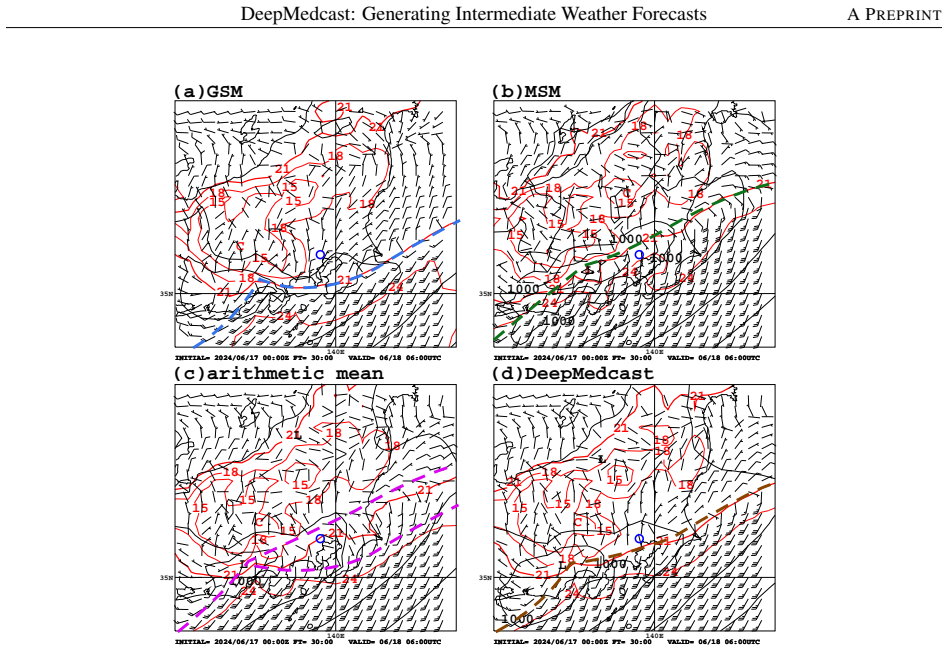
The paper claims that a U-Net trained on the time interpolation of one operational model (GSM) transfers to the spatial interpolation between different models (GSM, MSM, IFS, GraphCast, Pangu-Weather) at the same forecast time. An intermediate forecast is pragmatically defined as a field where meteorologically significant features—typhoon and extratropical cyclone centers, fronts, shear lines—lie at the arithmetic mean of the corresponding features in the input predictions, and that is more accurate against observations than the inputs. DeepMedcast achieves this by learning to place the continuous field at the midpoint without averaging the field values, thus avoiding the splitting and weakening seen with arithmetic means. The claim is supported by four case studies and by a one-year RMSE verification against AMeDAS surface wind observations, where DeepMedcast beat both GSM and MSM at all lead times.
Load-bearing premise
The load-bearing premise is that the mapping learned from temporally neighboring forecasts of one NWP model generalizes to same-time forecasts from different NWP models with different resolutions, physics, and biases, so the network interpolates between their features without retraining.
Editorial extensions
If this is right
- Forecasters can derive a single, interpretable pressure and wind field consistent with consensus tropical-cyclone track forecasts, reducing manual adjustment and standardizing warning workflows.
- The same trained network handles other operational and AI-driven models—MSM, IFS, GraphCast, Pangu-Weather—and model upgrades, without retraining or bias correction, lowering maintenance cost.
- Recursive application combines any power-of-two number of models (2, 4, 8, …), with outputs robust to the order of pairing.
- Verification against AMeDAS surface winds shows lower RMSE for wind speed and direction than the input GSM and MSM forecasts at all lead times from 3 to 39 hours.
- The method does not represent model spread or uncertainty, so practitioners should present the original model outputs and their spread alongside the intermediate forecast.
Reading between the lines
- This suggests a general recipe for feature-preserving interpolation between any two gridded fields—ocean models, air-quality fields, or medical images—whenever averaging blurs or splits sharp structures.
- A synthetic displacement test—shifting one field by a known distance and checking whether the output feature stays at the midpoint for increasing shifts—could map the method's effective range, which the paper only samples up to roughly 1000 km.
- The observed slight underestimate of typhoon maximum wind speed hints that an intensity or weighting condition added to the network could enable weighted (e.g., 1:2) intermediates and handle an odd number of models.
Editorial analysis
A structured set of objections, weighed in public.
Referee Report
Summary. The paper proposes DeepMedcast, a U-Net trained to map two forecast lead times (t-Δt, t+Δt) of a single NWP model (GSM) to the same model's forecast at t, and then applied at inference to simultaneous forecasts from two different NWP models to produce an 'intermediate forecast'. The paper claims that, unlike arithmetic averaging, DeepMedcast places meteorologically significant features (TC centers, fronts, shear lines) approximately at the arithmetic mean of the input models' feature positions without splitting or excessive smoothing, and that its surface wind forecasts have lower RMSE than either input model. Evidence consists of four visual case studies and a one-year AMeDAS verification of surface wind speed and direction.
Significance. If established, the claims would make DeepMedcast a practical and inexpensive post-processing tool for operational forecasting, with the notable strength that a single model trained on one NWP could be applied across multiple models without retraining. The paper is clearly structured, gives a complete description of the architecture and data, uses an independent one-year verification period, and provides data availability statements. The main weakness is that the distinctive structural claims rest on a handful of hand-picked cases, while the quantitative verification does not measure the claimed property.
major comments (3)
- [Sections 3.1-3.4] The central claim that DeepMedcast places features at the arithmetic-mean position without splitting or distortion is supported only by four hand-picked visual comparisons. No quantitative metric is reported for feature alignment (e.g., distance between DeepMedcast's TC center and the arithmetic mean of the input models' centers) or structural integrity (e.g., number of distinct SLP minima or frontal shear zones). Because the training target in Section 2.1 is the temporal midpoint of the same model, the 'intermediate' property is partly taught for same-model temporal interpolation; whether it transfers to cross-model spatial interpolation is exactly the claim that needs quantitative verification. I request a systematic evaluation with such metrics over all available cases or a season, not only the four displayed ones.
- [Section 3.5, Eq. (2)] The RMSE verification does not include the arithmetic-mean baseline and cannot detect the structural artifacts the method is designed to avoid. A smooth field can lower RMSE while splitting TC centers or fronts; conversely, a structurally correct field can have slightly higher RMSE. Also, the one-year RMSE curves are presented without confidence intervals or significance tests. I recommend adding the arithmetic-mean RMSE and a targeted structural metric (or at least an objective center-position error) to the verification.
- [Section 4.2] The maintainability claim that DeepMedcast can be applied to various NWP models without updating the DNN because it is not designed to correct NWP model biases is an assertion rather than a demonstrated result. The network is trained exclusively on GSM and may have learned GSM-specific vortex scales, smoothness, and normalization statistics; the inference inputs in Section 3 include models with different resolutions, physics, and biases. The same generalization concern applies to forecast lead time: training uses t = 9-14 h (Section 2.2), while the case studies apply the network at FT = 30, 51, 75, and 108 h. I ask for either a systematic cross-model and cross-lead-time evaluation or a tempered statement of this claim as a hypothesis.
minor comments (4)
- [Keywords] The keyword 'Intemediate' is misspelled; it should be 'Intermediate'.
- [References and Eq. (2)] Vannitsem et al. and Roberts et al. are cited as 'el al.' instead of 'et al.', and Eq. (2) contains 'T nad N' instead of 'T and N'.
- [Figure 9 caption] The caption spells the typhoon as 'KHANUM' while the text uses 'KHANUN'; the spelling should be made consistent.
- [Figures 6 and 10] The order-invariance discussion is purely qualitative; reporting the spread of the predicted center positions across the three orders would make the robustness claim easier to assess.
Circularity Check
The headline mean-position property is partly the network's training objective; the cross-model transfer that would make it non-circular is asserted rather than quantitatively established.
-
fitted input called prediction
[Section 2.2 (training data symmetry); cf. Abstract headline and Section 3 case studies]
"Both input channels are utilized by swapping their order, i.e., both FT = t - Δt and FT = t + Δt, as well as FT = t + Δt and FT = t - Δt, are employed to preserve symmetry. This strategy encourages the network to learn symmetric representations, so that meteorologically significant features—such as the center positions of TCs or extratropical cyclones, frontal boundaries, and shear lines—approximately align with the arithmetic mean of the corresponding features from the two input channels."
The headline capability stated in the Abstract, that features 'approximately align with the arithmetic mean,' is asserted in Section 2.2 to be what the training procedure 'encourages the network to learn.' Because the training target is the same model's field at the middle lead time t, for a steadily moving feature the target position is the temporal midpoint of the two inputs, so the MSE fit builds the arithmetic-mean position into the output. The Section 3 case studies then report this same alignment as a demonstrated result, e.g., placing the typhoon 'halfway between GSM and MSM predictions.' Thus the mean-position finding largely reflects the training objective rather than an independent prediction.
full rationale
The paper's central transfer assumption, that a network trained to interpolate one NWP model in lead time can interpolate between two different NWP models at a fixed lead time, is not itself shown to be forced; Section 3.5's RMSE verification against AMeDAS observations is an external benchmark and therefore non-circular. However, the specific claim that DeepMedcast places cyclones, fronts, and shear lines at the arithmetic mean of the corresponding input features is stated in Section 2.2 as the objective of the training setup, so the case studies demonstrating that property are partly a check that the network achieved its training objective under a new setting rather than an independent prediction. The AMeDAS-based accuracy verification is independent, but it does not test the arithmetic-mean feature-position property. No load-bearing self-citation or imported uniqueness theorem appears; Section 4.2's maintainability claim is an assertion but not a circular reduction. Overall score 4 reflects partial circularity of the headline property, with independent content remaining in the cross-model generalization and the observation-based accuracy verification.
Assumptions & free parameters
free parameters (1)
- U-Net network weights =
not released
assumptions (5)
- domain assumption Interpolating a single model's forecasts between lead times is equivalent, for feature positions, to interpolating between two different models at the same lead time.
- domain assumption Meteorologically significant features move approximately linearly in position over the 3-6 hour time windows, so the middle target places features at the arithmetic mean of the inputs.
- standard math A U-Net with ReLU activations, Adam optimization, and MSE loss can learn the mapping from two input fields to one intermediate field.
- domain assumption Normalization using per-example min/max across the two input channels is sufficient and does not distort the interpolation learned in training.
- domain assumption GSM is representative enough that a network trained on it transfers to MSM, IFS, GraphCast, and Pangu-Weather.
Cite this review
Pith. "Pith review of DeepMedcast: A Deep Learning Method for Generating Intermediate Weather Forecasts among Multiple NWP Models." pith.science (2026). https://pith.science/paper/IGZ3OYTQ
@misc{pith2026241110010,
  author       = {Pith},
  title        = {Pith review of: DeepMedcast: A Deep Learning Method for Generating Intermediate Weather Forecasts among Multiple NWP Models},
  year         = {2026},
  howpublished = {\url{https://pith.science/paper/IGZ3OYTQ}},
  note         = {Machine review of arXiv:2411.10010}
}
read the original abstract
Numerical weather prediction (NWP) centers around the world operate a variety of NWP models. In addition, recent advances in AI-driven NWP models have further increased the availability of NWP outputs. While this expansion holds the potential to improve forecast accuracy, it raises a critical question: which prediction is the most plausible? If the NWP models have comparable accuracy, it is impossible to determine in advance which one is the best. Traditional approaches, such as ensemble or weighted averaging, combine multiple NWP outputs to produce a single forecast with improved accuracy. However, they often result in meteorologically unrealistic and uninterpretable outputs, such as the splitting of tropical cyclone centers or frontal boundaries into multiple distinct systems. To address this issue, we propose DeepMedcast, a deep learning method that generates intermediate forecasts between two or more NWP outputs. Unlike averaging, DeepMedcast provides predictions in which meteorologically significant features -- such as the locations of tropical cyclones, extratropical cyclones, fronts, and shear lines -- approximately align with the arithmetic mean of the corresponding features predicted by the input NWP models, without distorting meteorological structures. We demonstrate the capability of DeepMedcast through case studies and verification results, showing that it produces realistic and interpretable forecasts with higher accuracy than the input NWP models. By providing plausible intermediate forecasts, DeepMedcast can significantly contribute to the efficiency and standardization of operational forecasting tasks, including general, marine, and aviation forecasts.
Figures


Figures from the paper (8 more)




Reference graph
Works this paper leans on
-
[1]
Agueh, M. and G. Carlier, 2011: Barycenters in the Wasserstein space SIAM Journal on Mathematical Analysis, 43(2), 904–924. [Available at https://hal.science/hal-00637399v1/document.]
work page 2011
-
[2]
Bi,K.,L. Xie,H.Zhang, X.Chen, X.Gu, and Q.Tian, 2022: Pangu-Weather: A 3D High-Resolution System for Fast and Accurate Global Weather Forecast. arXiv preprint arXv:2211.02556
arXiv 2022
-
[3]
Bi, K., L. Xie, H. Zhang, X. Chen, X. Gu, and Q. Tina, 2023: Accurate medium-range global weather forecasting with 3D neural networks. Nature, 619 533–538. doi:10.1038/s41586-023-06185-3
-
[4]
Bodnar, C., W. P. Bruinsma, A. Lucic, M. Stanley, J. Brandstetter, P. Garvan, M. Riechert, J. Weyn, H. Dong, A. Vaughan, J. K. Gupta, K. Tambiratnam, A. Archibald, E. Heider, M. Welling, R. E. Turner, P. Perdikaris, 2024: Aurora: A Foundation Model of the Atmosphere. arXiv preprint arXiv:2405.13063
arXiv 2024
- [5]
- [6]
-
[7]
Cangialosi, J., B.J. Reinhart, and J. Martinez, 2023: National Hurricane Center verification report, 2023 Hurricane Season. Natinal Hurricane Center, 81pp. [Available at https://www.nhc.noaa.gov/verification/pdfs/Verification\_2023.pdf.]
work page 2023
-
[8]
Chen, K., T. Han, J. Gong, L. Bai, F. Ling, J. Luo, X. Chen, L. Ma, T. Zhang, R. Su, Y. Ci, B. Li, X. Yang, and W. Ouyang, 2023: FengWu: Pushing the Skillful Global Medium-range Weather Forecast beyond 10 Days Lead. arXiv preprint arXiv:2304.02948
arXiv 2023
Show all 44 references
-
[9]
Deng, J., W. Dong, R. Socher, L. Li, K. Li, and L. Fei-Fei, 2009: ImageNet: A large-scale hierarchical image database. IEEE Conference on Computer Vision and Pattern Recognition, 248–255
2009
-
[10]
Beyer, A
Dosovitskiy, A., L. Beyer, A. Kolesnikov, D. Weissenborn, X. Zhai, T. Unterthiner, M. Dehghani, M. Minderer, G. Heigold, S. Gelly, J. Uszkoreit, and N. Houlsby, 2020: An Image is Worth 16x16 Words: Transformers for Image Recognition at Scale. arXiv preprint arXiv:2010.11929
2020 arXiv
-
[11]
Dowell, D. C., C. R. Alexander, E. P. James, S. S. Weygandt, S. G. Benjamin, G. S. Manikin, B. T. Blake, J. M. Brown, J. B. Olson, M. Hu, T. G. Smirnova, T. Ladwig, J. S. Kenyon, R. Ahmadov, D. D. Turner, J. D. Duda, T. I. Alcott, 2022: The High-Resolution Rapid Refresh (HRRR)...
2022 doi
-
[12]
Duc, L. and Y. Sawada, 2024: Geometry of rainfall ensemble means: from arithmetic averages to Gaussian-Hellinger barycenters in unbalanced optimal transport. J. Meteor. Soc. Japan, 102, 35-47, https://doi.org/10.2151/jmsj.2024-003
2024 doi
-
[13]
European Centre for Medium-Range Weather Forecasts
ECMWF, 2024: IFS Documentation. European Centre for Medium-Range Weather Forecasts. [Available at https://www.ecmwf.int/en/publications/ifs-documentation.]
2024
-
[14]
Gopalakrishnan, S. G., F. Marks Jr., X. Zhang, J.-W. Bao, K.-S. Yeh, and R. Atlas, 2011: The experimental HWRF system: A study on the influence of horizontal resolution on the structure and intensity changes in tropical cyclones using an idealized framework. Mon. Wea. Rev., 13...
2011
-
[15]
Hagelin, S., J. Son, R. Swinbank, A. McCabe, N. Roberts, and W. Tennant, 2017: The Met Office convective-scale ensemble, MOGREPS-UK. Quart. J. Roy. Meteor. Soc., 143, 2846–2861
2017
-
[16]
Hamill, T. M., E. Engle, D. Myrick, M. Peroutka, C. Finan, and M. Scheuerer, 2017: The U.S. National Blend of Models for Statistical Postprocessing of Probability of Precipitation and Deterministic Precipitation Amount. Mon. Wea. Rev., 145, 3441–3463
2017
-
[17]
Han T., S. Guo, F. Ling, K. Chen, J. Gong, J. Luo, J. Gu, K. Dai, W. Ouyang, L. Bai, 2024: FengWu-GHR: Learning the Kilometer-scale Medium-range Global Weather Forecasting. arXiv preprint arXiv:2402.00059
2024 arXiv
-
[18]
Jain, and P
Ho, J., A. Jain, and P. Abbeel, 2020: Denoising Diffusion Probabilistic Models. arXiv preprint arXiv:2006.11239
2020 arXiv
-
[19]
International Civil Aviation Organization, 16pp
ICAO, 2016: Guidance on the harmonized WAFS grids for Cumulonimbus cloud, icing and turbulence forecasts (version 2.6). International Civil Aviation Organization, 16pp. [Available at https://www.icao.int/airnavigation/METP/MOG\
2016
-
[20]
Inverarity, G. W., W. J. Tennant, L. Anton, N. E. Bowler, A. M. Clayton, M. Jardak, A. C. Lorence, F. Rawlins, S. A. Thompson, M. S. Thurlow, D. N. Walters, and M. A. Wlasak, 2023: Met Office MOGREPS-G initialisation using an ensemble of hybrid four-dimensional ensemble variat...
2023
-
[21]
Report of Numerical Prediction Division, 64, 248 pp (in Japanese)
JMA, 2018: Instruction for guidance. Report of Numerical Prediction Division, 64, 248 pp (in Japanese). [Available at https://www.jma.go.jp/jma/kishou/books/nwpreport/64/No64\_all.pdf.]
2018
-
[22]
Japan Meteorological Agency, 143pp
JMA, 2022: Annual Report on the Activities of the RSMC Tokyo - Typhoon Center 2022. Japan Meteorological Agency, 143pp. [Available at https://www.jma.go.jp/jma/jma-eng/jma-center/rsmc-hp-pub-eg/AnnualReport/2022/Text/Text2022.pdf.]
2022
-
[23]
Japan Meteorological Agency, 262pp
JMA, 2024: Outline of the operational numerical weather prediction at the Japan Meteorological Agency. Japan Meteorological Agency, 262pp. [Available at https://www.jma.go.jp/jma/jma-eng/jma-center/nwp/outline-latest-nwp/index.htm.]
2024
-
[24]
P., and J
Kingma, D. P., and J. Ba, 2014: Adam: A Method for Stochastic Optimization. arXiv preprint arXiv:1412.6980
2014 arXiv
-
[25]
Sanchez-Gonzalez, M
Lam, R., A. Sanchez-Gonzalez, M. Willson, P. Wirnsberger, M. Fortunato, F. Alet, S. Ravuri, T. Ewalds, Z. Eaton-Rosen, W. Hu, A. Merose, S. Hoyer, G. Holland, O. Vinyals, J. Stott, A. Pritzel, S. Mohamed and P. Battaglia, 2022: GraphCast: Learning skillful medium-range global ...
2022 arXiv
-
[26]
Alexe, M
Lang, S., M. Alexe, M. Chantry, J. Dramsch, F. Pinault, B. Raoult, M. C. A. Clare, C. Lessig, M. Maier-Gerber, L. Magnusson, Z. B. Bouall\' e ue, A. P. Nemesio, P. D. Dueben, A. Brown, F. Pappenberger, F. Rabier, 2024: AIFS — ECMWF's data-driven forecasting system. arXiv prepr...
2024 arXiv
-
[27]
Bengio, and G
LeCun, Y., Y. Bengio, and G. Hinton, 2015: Deep learning. Nature, 521, 436–444
2015
-
[28]
Tantet, R
Le Coz, C., A. Tantet, R. Flamary, and R. Plougonven, 2023: A barycenter-based approach for the multi-model ensembling of subseasonal forecasts. arXiv preprint arXiv:2310:17933
2023
-
[29]
J., 1997: A Convexity Principle for Interacting Gases
McCann, R. J., 1997: A Convexity Principle for Interacting Gases. Advances in Mathematics, 128(1), 153–179
1997
-
[30]
Nair, V., and G. E. Hinton, 2010: Rectified linear units improve restricted Boltzmann machines. Proceedings of the Twenty-seventh International Conference on Machine Learning (ICML-10), Haifa, Israel, 807–814
2010
-
[31]
[Available at https://vlab.noaa.gov/ web/gfs/documentation.]
NCEP, 2016: Global Forecast System - Global Spectral Model (GSM) - v13.0.2. [Available at https://vlab.noaa.gov/ web/gfs/documentation.]
2016
-
[32]
Fukuda, 2019: Advancement of Tropical Cyclone Track Forecasts
Nishimura, S., and J. Fukuda, 2019: Advancement of Tropical Cyclone Track Forecasts. Yohou Gijutsu Kenshu Text, 24, 114–141 (in Japanese). [Available at https://www.jma.go.jp/jma/kishou/books/yohkens/24/all.pdf.]
2019
-
[33]
Subramanian, P
Pathak, J., S. Subramanian, P. Harrington, S. Raja, A. Chattopadhyay, M. Mardani, T. Kurth, D. Hall, Z. Li, K. Azizzadenesheli, P. Hassanzadeh, K. Kashinath, and A. Anandkumar, 2022: FourCastNet: A Global Data-driven High-resolution Weather Model using Adaptive Fourier Neural ...
2022 arXiv
-
[34]
Cuturi, 2020: Computational Optimal Transport
Peyr\' e , G., and M. Cuturi, 2020: Computational Optimal Transport. arXiv preprint arXiv: 1803.00567
2020 arXiv
-
[35]
Sanchez-Gonzalez, F
Price, I., A. Sanchez-Gonzalez, F. Alet, T. R. Andersson, A. El-Kadi, D. Masters, T. Ewalds, J. Stott, S. Mohamed, P. Battaglia, R. Lam, M. Willson, 2023: GenCast: Diffusion-based ensemble forecasting for medium-range weather. arXiv preprint arXiv:2312.15796
2023 arXiv
-
[36]
Schulz, S
Primo, C., B. Schulz, S. Lerch, and R. Hess, 2024: Comparison of Model Output Statistics and Neural Networks to Postprocess Wind Gusts. arXiv preprint arXiv:2401.11896
2024 arXiv
-
[37]
Benjamin, E
Roberts, N., A. Benjamin, E. Gavin, M. Stephen, R. Fiona, S. Caroline, T. Tomasz, A. Paul, B, Laurence. C. Neil, F. Ben, F. Jonathan, G. Tom, H. Leigh, H. Aaron, H. Katharine, J. Simon, J. Caroline, M. Ken, S. Christopher, S. Michael, W. Bruce, B. Simon, B. Mark, B. Daniel, B....
2023
-
[38]
Fischer, and T
Ronneberger, O., P. Fischer, and T. Brox, 2015: U-Net: Convolutional Networks for Biomedical Image Segmentation. arXiv preprint arXiv:1505.04597
2015 arXiv
-
[39]
Simon, A., A. B. Penny, M. DeMaria, J. L. Franklin, R. J. Pasch, E. N. Rappaport, and D. A. Zelinsky, 2018: A description of the real-time HFIP Corrected Consensus Approach (HCCA) for Tropical Cyclone Track and Intensity Guidance. Wea. Forecasting, 33, 37–57, doi:10.1175/WAF-D...
2018 doi
-
[40]
Song, Y. and S. Ermon, 2019: Generative Modeling by Estimating Gradients of the Data Distribution. arXiv preprint arXiv:1907.05600
2019 arXiv
-
[41]
Vannitsem, S., J. B. Bremnes, J. Demaeyer, G. Evans, J. Flowerdew, S. Hemri, S. Lerch, N. Roberts, S. Theis, A. Atencia, Z. B. Bouall\' e gue, J. Bhend, M. Dabernig, L. D. Cruz, L. Hieta, O. Mestre, L. Moret, I. O. Plenkovic, M. Schmeits, J. Ylh\" a isi, 2021: Statistical Post...
2021
-
[42]
Shazeer, N
Vaswani, A., N. Shazeer, N. Parmar, J. Uszkoreit, L. Jones, A. N. Gomez, L. Kaiser, and I. Polosukhin 2017: Attention Is All You Need, arXiv preprint arXiv:1706.03762
2017 arXiv
-
[43]
L., and J
Vislocky, R. L., and J. M. Fritsch, 1997: Performance of an advanced MOS system in the 1996–97 National Collegiate Weather Forecasting Contest. Bull. Amer. Meteor. Soc., 78, 2851–2857
1997
-
[44]
Bulletin nº, 62, 11–15
WMO, 2013: Cascading Process to Improve Forecasting and Warning Services. Bulletin nº, 62, 11–15. [Available at https://public.wmo.int/en/resources/bulletin/cascading-process-improve-forecasting-and-warning-services.]
2013
Reviewed August 12, 2026 · model on record in the stance chip above.
Discussion (0). Continue with ORCID to comment.