REVIEW 4 major objections 5 minor 40 references
InCrowd-VI: A Realistic Visual-Inertial Dataset for Evaluating SLAM in Indoor Pedestrian-Rich Spaces for Human Navigation
T0 review · 4 major / 5 minor · reviewed 2026-08-12 · deepseek-v4-flash
Pith's one-line read This paper introduces a head-worn visual-inertial dataset of 58 indoor pedestrian-rich sequences and shows that two classical and two deep-learning localization systems all fail the combined accuracy, drift, and real-time requirements…
desk verdict A genuinely useful new dataset for crowded indoor SLAM evaluation, but the headline numbers rest on a ground-truth reference that is only locally validated. read the letter →
The pith
A machine-rendered reading of the paper's core claim, the machinery that carries it, and where it could break.
The reading
What carries the argument
The load-bearing object is the dataset itself, together with its ground-truth generation pipeline. The sensor rig is a head-worn stereo pair with wide field-of-view monocular cameras, a higher-resolution RGB camera, and dual IMUs; InCrowd-VI releases the stereo image pairs, RGB frames, IMU streams at 1000 and 800 Hz, semi-dense point clouds, and per-sequence trajectory ground truth. The ground truth is produced by an offline SLAM service that fuses all of the device's sensors with post-processing, conditions that are deliberately impractical for a real-time wearable, and the paper validates it by measuring distances between recognizable landmarks in the reconstructed point cloud and comparing them with physical measurements, reporting an average error of about 2 cm. The evaluation harness uses four metrics: absolute trajectory error as root mean square error, drift percentage defined as trajectory error divided by path length, pose estimation coverage as the fraction of frames with an estimated pose, and a real-time factor comparing the distance processed per second with the user's walking speed. These metrics are what carry the conclusion that every tested system fails at least one requirement.
What would settle it
Measure the full 5 km of trajectories against an independent survey-grade reference, for example a total station or fixed motion-capture system covering the long and crowded sequences, and compare; if the offline SLAM ground truth deviates by well over 2 cm in precisely the scenes where the tested systems fail, the benchmark's error numbers are biased and the failure conclusion would need to be re-tested.
Extended reading notes
Core claim
The central claim is that crowded indoor scenes are precisely where current visual-inertial SLAM breaks, and that the lack of a benchmark reflecting those conditions has been hiding the gap. InCrowd-VI supplies that benchmark: 58 sequences recorded from a walking person's head-mounted stereo camera pair, covering crowd densities from empty to more than ten pedestrians per frame, with occlusions, reflective and glass surfaces, flickering or dim light, stairs, escalators, and moving ramps. Ground-truth trajectories come from an offline, post-processed machine-perception SLAM service that uses the full sensor suite of the recording glasses and removes dynamic pedestrians from the map; manual comparisons of landmark distances in the reconstructed point cloud against real-world measurements give a mean deviation of about 2 cm. On the dataset, two classical and two deep-learning visual odometry and SLAM systems all miss the stated combined bar somewhere: the worst classical runs drift 21-50% of trajectory length, and the learning-based systems keep pose coverage above 90% but run several times slower than real time at walking pace. The paper concludes that no tested system is ready for reliable visually impaired navigation in complex indoor pedestrian-rich spaces.
Load-bearing premise
The ground-truth trajectories come from an offline localization service that is itself a SLAM system, and its claimed accuracy of about 2 cm was checked by manual measurements on only part of the data; if that service's errors grow in long or heavily crowded sequences, every reported error and failure verdict would be biased.
Editorial extensions
If this is right
- SLAM researchers get a public benchmark whose crowd densities, lighting changes, and motion transitions reproduce realistic indoor navigation rather than lab or vehicle settings.
- Classical feature-based and semi-direct systems can no longer claim robustness on the basis of empty indoor or outdoor datasets, because on InCrowd-VI their drift frequently exceeds 5-10% of trajectory length.
- Deep-learning systems, despite high pose coverage, must become substantially faster before they can serve as real-time navigation aids for walking users.
- Application designers for visually impaired navigation should treat the 0.5 m, 1% drift, and real-time requirements as a concrete target, since no evaluated system meets them together on the hard sequences.
- The dataset's lack of depth data and its indoor-only scope define natural next steps: depth-based SLAM and indoor-outdoor transitions cannot be tested with it.
Reading between the lines
- Because the reference trajectories are themselves produced by an offline SLAM service, InCrowd-VI is strongest for comparing systems against each other; absolute accuracy claims inherit whatever errors that service has in scenes where manual validation was not performed.
- The 0.5 m and 1% thresholds are application choices; a different task, such as low-speed assistive navigation in familiar buildings, might tolerate larger errors, so the failure verdict should not be over-generalized.
- A natural testable extension is per-frame failure annotation, such as occlusion fraction, motion blur, and textureness, which would turn the dataset from a pass-fail benchmark into a diagnostic tool for why tracking is lost.
- The dataset's average walking speed of 0.75 m/s, below typical sighted walking speed, slightly relaxes the real-time requirement; a system that fails the real-time factor here could still be adequate for slower users.
Editorial analysis
A structured set of objections, weighed in public.
Referee Report
Summary. The manuscript introduces InCrowd-VI, a visual-inertial dataset for evaluating SLAM in indoor pedestrian-rich environments, recorded with Meta Aria glasses across 58 sequences totaling about 5 km and 1.5 hours. The dataset provides RGB, stereo, and IMU data, semi-dense point clouds, and ground-truth trajectories produced by the Meta Aria machine perception SLAM service, with reported accuracy of about 2 cm based on manual landmark-distance validation. The paper evaluates four SLAM/VO systems (ORB-SLAM3, SVO, DROID-SLAM, DPV-SLAM) on a subset of sequences using ATE, drift percentage, pose estimation coverage, and a real-time factor, concluding that current systems fail to meet the accuracy, robustness, and real-time requirements for visually impaired navigation.
Significance. If the ground-truth accuracy claim holds, InCrowd-VI would be a valuable community resource: it targets an underexplored regime (head-worn, pedestrian-rich indoor navigation), provides realistic human motion and crowd densities, and ships public data plus conversion tools. The evaluation is also useful as a stress test for current SLAM systems, and the introduced PEC and RTF metrics add practical evaluation dimensions beyond ATE alone. The main contributions are empirical and dataset-oriented rather than algorithmic, and the paper is transparent about the sensor setup and calibration. However, the benchmark's central claim depends on the reliability of the Aria SLAM service as ground truth, which is only locally validated, and on the representativeness of the evaluated sequence subset; both points need strengthening before the dataset can be adopted as a benchmark.
major comments (4)
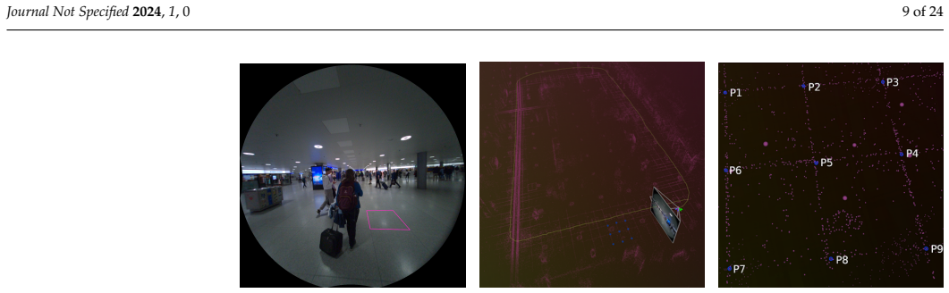
- [§3.3, Figures 1–2] The ground-truth validation is not sufficient to support the claimed trajectory accuracy for all 58 sequences. The manual measurements compare distances between landmarks in the reconstructed point cloud with real-world tape-measure distances; this validates the local metric scale of the static map, not the global trajectory error that ATE and DP measure. A trajectory can reconstruct local geometry to within 2 cm while accumulating large drift over long loops or in sequences with tracking difficulty. Since the reference is itself produced by the Meta Aria machine perception SLAM service, any drift in that service (for example in Kiko_loop, G8_cafe, or Getoff_pharmacy) would be attributed to the evaluated systems. The validation was performed on selected crowded sequences and on a few failure sequences, not on most of the 58 sequences, and it checks inter-landmark distances rather than absolute pose error. The paper should either provide per-sequence trajectory uncertainty estimates, validate global consistency with an independent method (e.g., surveyed waypoints, loop-closure constraints, or a total station), or explicitly restrict the accuracy claim to the local metric scale and adjust the benchmark conclusions accordingly.
- [§4, Table 6] The evaluation is performed on 19 of the 58 sequences, but the selection protocol is not specified beyond stating that the sequences 'represent a range of difficulty levels from easy to hard.' The main conclusions—that state-of-the-art systems fail in this dataset and that drift reaches 5–10%—are extrapolated from this convenience subset. If the subset is biased toward the hardest sequences, the dataset-level failure rate is overstated; if it is biased toward easier sequences, the dataset's challenge level is understated. The authors should evaluate all sequences or clearly document the selection criteria and show that the selected subset has the same distribution of crowd density, trajectory length, and environmental challenges as the full dataset.
- [§4.1, Table 6] Several reported ATE values are associated with very low pose estimation coverage, yet they are presented without flags and are used in the aggregate analysis. For example, in TH_loop the SVO row reports ATE = 0.01 m with PEC = 0.9%, and in UZH_stairs SVO reports PEC = 37%; these are effectively failed runs, and their ATE values are computed on a tiny fraction of the trajectory. The paper itself states that a notably low PEC makes ATE unreliable, but Table 6 still lists these numbers as if they were comparable to high-coverage results. These low-coverage entries should be excluded from the summary statistics or clearly marked as failures, so that the reported drift and accuracy comparisons are not distorted.
- [§4, 'Experimental Evaluation'] The four systems are not compared under equivalent sensor configurations: ORB-SLAM3 is evaluated with the left camera plus IMU, while SVO, DROID-SLAM, and DPV-SLAM use only the left monocular camera. This confounds the comparison between classical and deep-learning approaches, since visual-inertial SLAM has access to scale and gyroscopic measurements that monocular systems lack. The conclusion that deep-learning methods are more robust than classical methods, or that classical methods drift more, is not a head-to-head comparison of the algorithms as typically used. The authors should either evaluate all systems in both monocular and visual-inertial modes (where supported) or clearly reframe the results as per-system capability assessments rather than comparative rankings.
minor comments (5)
- [§3.4] There is a typo: 'Meta-Ariana glasses' should read 'Meta Aria glasses.' Additionally, 'approximately 1T GB' should be corrected to a proper storage unit, such as 'approximately 1 TB.'
- [References] Reference [38] points to an 'edit.paperpal.com' URL, which appears to be an artifact of a writing tool rather than the actual TUM RGB-D benchmark tools page; the canonical URL for the TUM evaluation tools should be used instead.
- [Figure 8] The caption for Figure 8(a) contains a misspelling ('Midium' instead of 'Medium') and labels 'DROID-SLAM3' in the legend while the text and Table 5 refer to 'DROID-SLAM'; these should be made consistent.
- [§4.1] The definition of PEC as '(number of estimated poses/total number of frames) × 100' should clarify whether estimated poses are counted only for frames where tracking succeeded and how the denominator handles sequences with dropped or corrupted frames; this affects the interpretation of PEC values such as 0.9%.
- [Front matter] The manuscript is formatted with an MDPI template that still contains placeholder text ('Journal Not Specified 2024, 1, 0', a placeholder DOI, and empty Received/Accepted dates); these must be resolved for the final published version.
Circularity Check
No significant circularity: the ground-truth trajectories come from an external SLAM service, are manually validated, and the evaluated systems are distinct from the ground-truth generator.
full rationale
The paper's central evaluation claim is that state-of-the-art VO/SLAM systems fail on InCrowd-VI. The ground truth is produced by the Meta Aria machine perception SLAM service, which is an external system cited from the Project Aria paper, not from the present authors' prior work. The evaluated systems (ORB-SLAM3, SVO, DROID-SLAM, DPV-SLAM) are all different from that service, and none of their outputs are fed back into the ground-truth generation. The authors also provide independent manual landmark-distance measurements in Section 3.3, reporting an average error of about 2 cm, which supports the reference trajectories without relying on the evaluated algorithms. The fact that the ground truth is itself produced by a SLAM/VIO system is a legitimate limitation regarding the independence of the reference, and the validation covers only selected sequences and local distances, but this is a question of ground-truth quality and benchmark validity, not circular reasoning. No equation reduces a prediction to an input, no fitted parameter is renamed as a result, and no load-bearing self-citation is present. Accordingly, no specific circular step can be exhibited, and the circularity score is 0.
Assumptions & free parameters
assumptions (3)
- domain assumption The Meta Aria machine perception SLAM service produces ground-truth trajectories with typical global RMSE translation error of no more than 1.5 cm in room-scale scenarios.
- domain assumption Manual landmark distance measurements confirm the ground-truth accuracy to approximately 2 cm.
- domain assumption The subset of sequences chosen for the SLAM evaluation is representative of the dataset's challenges.
Cite this review
Pith. "Pith review of InCrowd-VI: A Realistic Visual-Inertial Dataset for Evaluating SLAM in Indoor Pedestrian-Rich Spaces for Human Navigation." pith.science (2026). https://pith.science/paper/6KEB7WDG
@misc{pith2026241114358,
  author       = {Pith},
  title        = {Pith review of: InCrowd-VI: A Realistic Visual-Inertial Dataset for Evaluating SLAM in Indoor Pedestrian-Rich Spaces for Human Navigation},
  year         = {2026},
  howpublished = {\url{https://pith.science/paper/6KEB7WDG}},
  note         = {Machine review of arXiv:2411.14358}
}
read the original abstract
Simultaneous localization and mapping (SLAM) techniques can be used to navigate the visually impaired, but the development of robust SLAM solutions for crowded spaces is limited by the lack of realistic datasets. To address this, we introduce InCrowd-VI, a novel visual-inertial dataset specifically designed for human navigation in indoor pedestrian-rich environments. Recorded using Meta Aria Project glasses, it captures realistic scenarios without environmental control. InCrowd-VI features 58 sequences totaling a 5 km trajectory length and 1.5 hours of recording time, including RGB, stereo images, and IMU measurements. The dataset captures important challenges such as pedestrian occlusions, varying crowd densities, complex layouts, and lighting changes. Ground-truth trajectories, accurate to approximately 2 cm, are provided in the dataset, originating from the Meta Aria project machine perception SLAM service. In addition, a semi-dense 3D point cloud of scenes is provided for each sequence. The evaluation of state-of-the-art visual odometry (VO) and SLAM algorithms on InCrowd-VI revealed severe performance limitations in these realistic scenarios. Under challenging conditions, systems exceeded the required localization accuracy of 0.5 meters and the 1\% drift threshold, with classical methods showing drift up to 5-10\%. While deep learning-based approaches maintained high pose estimation coverage (>90\%), they failed to achieve real-time processing speeds necessary for walking pace navigation. These results demonstrate the need and value of a new dataset to advance SLAM research for visually impaired navigation in complex indoor environments. The dataset and associated tools are publicly available at https://incrowd-vi.cloudlab.zhaw.ch/.
Figures


Figures from the paper (5 more)


Reference graph
Works this paper leans on
-
[1]
Simultaneous localization and mapping: part I
Durrant-Whyte, H.; Bailey, T. Simultaneous localization and mapping: part I. IEEE robotics & automation magazine 2006, 13, 99–110
work page 2006
-
[2]
Past, present, and future of simultaneous localization and mapping: Toward the robust-perception age
Cadena, C.; Carlone, L.; Carrillo, H.; Latif, Y.; Scaramuzza, D.; Neira, J.; Reid, I.; Leonard, J.J. Past, present, and future of simultaneous localization and mapping: Toward the robust-perception age. IEEE Transactions on robotics2016, 32, 1309–1332
-
[3]
Deep Visual Odometry with Events and Frames
Pellerito, R.; Cannici, M.; Gehrig, D.; Belhadj, J.; Dubois-Matra, O.; Casasco, M.; Scaramuzza, D. Deep Visual Odometry with Events and Frames. In Proceedings of the IEEE/RSJ International Conference on Intelligent Robots and Systems (IROS. IEEE, 2024
work page 2024
-
[4]
Simultaneous localization and mapping: A survey of current trends in autonomous driving
Bresson, G.; Alsayed, Z.; Yu, L.; Glaser, S. Simultaneous localization and mapping: A survey of current trends in autonomous driving. IEEE Transactions on Intelligent Vehicles2017, 2, 194–220
-
[5]
Autonomous drone racing: A survey
Hanover, D.; Loquercio, A.; Bauersfeld, L.; Romero, A.; Penicka, R.; Song, Y.; Cioffi, G.; Kaufmann, E.; Scaramuzza, D. Autonomous drone racing: A survey. IEEE Transactions on Robotics 2024. Journal Not Specified 2024, 1, 0 23 of 24
work page 2024
-
[6]
Structure-Invariant Range-Visual-Inertial Odometry
Alberico, I.; Delaune, J.; Cioffi, G.; Scaramuzza, D. Structure-Invariant Range-Visual-Inertial Odometry. arXiv preprint arXiv:2409.04633 2024
work page Pith review arXiv 2024
-
[7]
Project Aria: A new tool for egocentric multi-modal AI research
Somasundaram, K.; Dong, J.; Tang, H.; Straub, J.; Yan, M.; Goesele, M.; Engel, J.J.; De Nardi, R.; Newcombe, R. Project Aria: A new tool for egocentric multi-modal AI research. arXiv preprint arXiv:2308.13561 2023
arXiv 2023
-
[8]
Hilti-oxford dataset: A millimeter- accurate benchmark for simultaneous localization and mapping
Zhang, L.; Helmberger, M.; Fu, L.F.T.; Wisth, D.; Camurri, M.; Scaramuzza, D.; Fallon, M. Hilti-oxford dataset: A millimeter- accurate benchmark for simultaneous localization and mapping. IEEE Robotics and Automation Letters 2022, 8, 408–415
work page 2022
Show all 40 references
-
[9]
Are we ready for autonomous driving? the kitti vision benchmark suite
Geiger, A.; Lenz, P .; Urtasun, R. Are we ready for autonomous driving? the kitti vision benchmark suite. In Proceedings of the 2012 IEEE conference on computer vision and pattern recognition. IEEE, 2012, pp. 3354–3361
2012
-
[10]
The EuRoC micro aerial vehicle datasets
Burri, M.; Nikolic, J.; Gohl, P .; Schneider, T.; Rehder, J.; Omari, S.; Achtelik, M.W.; Siegwart, R. The EuRoC micro aerial vehicle datasets. The International Journal of Robotics Research 2016, 35, 1157–1163
2016
-
[11]
Penncosyvio: A challenging visual inertial odometry benchmark
Pfrommer, B.; Sanket, N.; Daniilidis, K.; Cleveland, J. Penncosyvio: A challenging visual inertial odometry benchmark. In Proceedings of the 2017 IEEE International Conference on Robotics and Automation (ICRA). IEEE, 2017, pp. 3847–3854
2017
-
[12]
The Zurich urban micro aerial vehicle dataset
Majdik, A.L.; Till, C.; Scaramuzza, D. The Zurich urban micro aerial vehicle dataset. The International Journal of Robotics Research 2017, 36, 269–273
2017
-
[13]
Interiornet: Mega-scale multi-sensor photo-realistic indoor scenes dataset
Li, W.; Saeedi, S.; McCormac, J.; Clark, R.; Tzoumanikas, D.; Ye, Q.; Huang, Y.; Tang, R.; Leutenegger, S. Interiornet: Mega-scale multi-sensor photo-realistic indoor scenes dataset. arXiv preprint arXiv:1809.00716 2018
2018 arXiv
-
[14]
The TUM VI benchmark for evaluating visual-inertial odometry
Schubert, D.; Goll, T.; Demmel, N.; Usenko, V .; Stückler, J.; Cremers, D. The TUM VI benchmark for evaluating visual-inertial odometry. In Proceedings of the 2018 IEEE/RSJ International Conference on Intelligent Robots and Systems (IROS). IEEE, 2018, pp. 1680–1687
2018
-
[15]
Are we ready for autonomous drone racing? the UZH-FPV drone racing dataset
Delmerico, J.; Cieslewski, T.; Rebecq, H.; Faessler, M.; Scaramuzza, D. Are we ready for autonomous drone racing? the UZH-FPV drone racing dataset. In Proceedings of the 2019 International Conference on Robotics and Automation (ICRA). IEEE, 2019, pp. 6713–6719
2019
-
[16]
The newer college dataset: Handheld lidar, inertial and vision with ground truth
Ramezani, M.; Wang, Y.; Camurri, M.; Wisth, D.; Mattamala, M.; Fallon, M. The newer college dataset: Handheld lidar, inertial and vision with ground truth. In Proceedings of the 2020 IEEE/RSJ International Conference on Intelligent Robots and Systems (IROS). IEEE, 2020, pp. 4353–4360
2020
-
[17]
Viode: A simulated dataset to address the challenges of visual-inertial odometry in dynamic environments
Minoda, K.; Schilling, F.; Wüest, V .; Floreano, D.; Yairi, T. Viode: A simulated dataset to address the challenges of visual-inertial odometry in dynamic environments. IEEE Robotics and Automation Letters 2021, 6, 1343–1350
2021
-
[18]
Large-scale localization datasets in crowded indoor spaces
Lee, D.; Ryu, S.; Yeon, S.; Lee, Y.; Kim, D.; Han, C.; Cabon, Y.; Weinzaepfel, P .; Guérin, N.; Csurka, G.; et al. Large-scale localization datasets in crowded indoor spaces. In Proceedings of the Proceedings of the IEEE/CVF Conference on Computer Vision and Pattern Recognitio...
2021
-
[19]
Self-improving SLAM in dynamic environments: learning when to mask
Bojko, A.; Dupont, R.; Tamaazousti, M.; Borgne, H.L. Self-improving SLAM in dynamic environments: learning when to mask. arXiv preprint arXiv:2210.08350 2022
2022 arXiv
-
[20]
CID-SIMS: Complex indoor dataset with semantic information and multi-sensor data from a ground wheeled robot viewpoint
Zhang, Y.; An, N.; Shi, C.; Wang, S.; Wei, H.; Zhang, P .; Meng, X.; Sun, Z.; Wang, J.; Liang, W.; et al. CID-SIMS: Complex indoor dataset with semantic information and multi-sensor data from a ground wheeled robot viewpoint. The International Journal of Robotics Research 2023...
2023
-
[21]
A dataset for human localization and mapping with wearable sensors
Recchiuto, C.T.; Scalmato, A.; Sgorbissa, A. A dataset for human localization and mapping with wearable sensors. Robotics and Autonomous Systems 2017, 97, 136–143
2017
-
[22]
ADVIO: An authentic dataset for visual-inertial odometry
Cortés, S.; Solin, A.; Rahtu, E.; Kannala, J. ADVIO: An authentic dataset for visual-inertial odometry. In Proceedings of the Proceedings of the European Conference on Computer Vision (ECCV), 2018, pp. 419–434
2018
-
[23]
Benchmarking Pedestrian Odometry: The Brown Pedestrian Odometry Dataset (BPOD)
Charatan, D.; Fan, H.; Kimia, B. Benchmarking Pedestrian Odometry: The Brown Pedestrian Odometry Dataset (BPOD). In Proceedings of the 2022 International Conference on 3D Vision (3DV). IEEE, 2022, pp. 1–11
2022
-
[24]
Simultaneous localization and mapping related datasets: A comprehensive survey
Liu, Y.; Fu, Y.; Chen, F.; Goossens, B.; Tao, W.; Zhao, H. Simultaneous localization and mapping related datasets: A comprehensive survey. arXiv preprint arXiv:2102.04036 2021
2021 arXiv
-
[25]
How NeRFs and 3D Gaussian Splatting are Reshaping SLAM: a Survey
Tosi, F.; Zhang, Y.; Gong, Z.; Sandström, E.; Mattoccia, S.; Oswald, M.R.; Poggi, M. How NeRFs and 3D Gaussian Splatting are Reshaping SLAM: a Survey. arXiv preprint arXiv:2402.13255 2024
2024 arXiv
-
[26]
Project Aria Hardware Specifications: https://facebookresearch.github.io/projectaria_tools/docs/tech_spec/ hardware_spec, 2024
Meta AI Research. Project Aria Hardware Specifications: https://facebookresearch.github.io/projectaria_tools/docs/tech_spec/ hardware_spec, 2024. [Online; accessed 2024-09-04]
2024
-
[27]
Camera Intrinsic Models for Project Aria devices: https://facebookresearch.github.io/projectaria_tools/docs/ tech_insights/camera_intrinsic_models
Meta AI Research. Camera Intrinsic Models for Project Aria devices: https://facebookresearch.github.io/projectaria_tools/docs/ tech_insights/camera_intrinsic_models. [Online; accessed 2024-09-04]
2024
-
[28]
Camera Intrinsic Models for Project Aria devices: https://facebookresearch.github.io/projectaria_tools/docs/ tech_insights/sensor_measurement_model
Meta AI Research. Camera Intrinsic Models for Project Aria devices: https://facebookresearch.github.io/projectaria_tools/docs/ tech_insights/sensor_measurement_model. [Online; accessed 2024-09-04]
2024
-
[29]
Meta AI Research. 3D Coordinate Frame Conventions for Project Aria Glasses: https://facebookresearch.github.io/projectaria_ tools/docs/data_formats/coordinate_convention/3d_coordinate_frame_convention. [Online; accessed 2024-09-04]
2024
-
[30]
Bad slam: Bundle adjusted direct rgb-d slam
Schops, T.; Sattler, T.; Pollefeys, M. Bad slam: Bundle adjusted direct rgb-d slam. In Proceedings of the Proceedings of the IEEE/CVF Conference on Computer Vision and Pattern Recognition, 2019, pp. 134–144
2019
-
[31]
Walking biomechanics and energetics of individuals with a visual impairment: a preliminary report
Bennett, H.J.; Valenzuela, K.A.; Fleenor, K.; Morrison, S.; Haegele, J.A. Walking biomechanics and energetics of individuals with a visual impairment: a preliminary report. Human Movement 2019, 20, 8–18
2019
-
[32]
Droid-slam: Deep visual slam for monocular, stereo, and rgb-d cameras
Teed, Z.; Deng, J. Droid-slam: Deep visual slam for monocular, stereo, and rgb-d cameras. Advances in neural information processing systems 2021, 34, 16558–16569. Journal Not Specified 2024, 1, 0 24 of 24
2021
-
[33]
Deep Patch Visual SLAM
Lipson, L.; Teed, Z.; Deng, J. Deep Patch Visual SLAM. arXiv preprint arXiv:2408.01654 2024
2024 arXiv
-
[34]
Orb-slam3: An accurate open-source library for visual, visual–inertial, and multimap slam
Campos, C.; Elvira, R.; Rodríguez, J.J.G.; Montiel, J.M.; Tardós, J.D. Orb-slam3: An accurate open-source library for visual, visual–inertial, and multimap slam. IEEE Transactions on Robotics 2021, 37, 1874–1890
2021
-
[35]
SVO: Semidirect visual odometry for monocular and multicamera systems
Forster, C.; Zhang, Z.; Gassner, M.; Werlberger, M.; Scaramuzza, D. SVO: Semidirect visual odometry for monocular and multicamera systems. IEEE Transactions on Robotics 2016, 33, 249–265
2016
-
[36]
Deep patch visual odometry
Teed, Z.; Lipson, L.; Deng, J. Deep patch visual odometry. Advances in Neural Information Processing Systems 2024, 36
2024
-
[37]
A benchmark for the evaluation of RGB-D SLAM systems
Sturm, J.; Engelhard, N.; Endres, F.; Burgard, W.; Cremers, D. A benchmark for the evaluation of RGB-D SLAM systems. In Proceedings of the 2012 IEEE/RSJ international conference on intelligent robots and systems. IEEE, 2012, pp. 573–580
2012
-
[38]
Useful tools for the RGB-D benchmark
Computer Vision Group TUM School of Computation, I.; of Munich, T.T.U. Useful tools for the RGB-D benchmark. https: //edit.paperpal.com/documents/a108dfc5-1231-4f54-a402-15d7c7b5f556
-
[39]
A tutorial on quantitative trajectory evaluation for visual (-inertial) odometry
Zhang, Z.; Scaramuzza, D. A tutorial on quantitative trajectory evaluation for visual (-inertial) odometry. In Proceedings of the 2018 IEEE/RSJ International Conference on Intelligent Robots and Systems (IROS). IEEE, 2018, pp. 7244–7251
2018
-
[40]
evo: Python package for the evaluation of odometry and SLAM
Grupp, M. evo: Python package for the evaluation of odometry and SLAM. https://github.com/MichaelGrupp/evo, 2017. Disclaimer/Publisher’s Note: The statements, opinions and data contained in all publications are solely those of the individual author(s) and contributor(s) and no...
2017
Reviewed August 12, 2026 · model on record in the stance chip above.
Discussion (0). Continue with ORCID to comment.