REVIEW 3 major objections 5 minor 53 references
SRMamba: Mamba for Super-Resolution of LiDAR Point Clouds
T0 review · 3 major / 5 minor · reviewed 2026-08-15 · deepseek-v4-flash
Pith's one-line read SRMamba reconstructs 4x denser LiDAR point clouds from sparse scans using a state-space range-image network, and reports better geometry than attention-based baselines.
desk verdict Solid but incremental range-view LiDAR SR; the Hough-voting preprocessing is the real novelty, but the evaluation's synthetic downsampling and missing error bars keep the superiority claim conditional. read the letter →
The pith
A machine-rendered reading of the paper's core claim, the machinery that carries it, and where it could break.
The reading
What carries the argument
The central machinery is a range-image preprocessing pipeline followed by a visual state-space (VSS) block inside an asymmetric U-Net. A spherical projection maps each LiDAR point to a range image using per-beam vertical offsets; Hough voting estimates projected coordinate offsets and a hole-compensation window fills the remaining empty pixels before the network sees the image. The network is an asymmetric U-Net whose stages are VSS blocks: the SS2D module scans the feature map left-to-right, right-to-left, top-to-bottom, and bottom-to-top, giving a global receptive field with linear-time state updates instead of quadratic attention. Skip connections provide multi-scale feature fusion, PixelShuffle upsamples the range image to four times its height, and the resulting depth map is back-projected to 3D space.
What would settle it
Record a scene simultaneously with a high-beam LiDAR and a real low-beam LiDAR, train SRMamba on the genuine low-beam scans, and compare its upsampled cloud to the high-beam ground truth; if the IoU and Chamfer Distance margins over the Transformer baselines shrink to noise, or the oblique-view geometry drifts, the synthetic-downsampling premise fails.
Extended reading notes
Core claim
SRMamba's central claim is that range-view LiDAR super-resolution fails on novel viewpoints because projection leaves horizontal holes and because windowed attention cannot capture long-range 3D spatial dependencies. The paper proposes to fix both: Hough voting plus hole compensation repairs the range image before learning, and a visual state-space backbone with multi-directional scanning replaces attention. On the 64-beam urban benchmark, SRMamba-L reaches IoU 0.4548 and Chamfer Distance 0.0940, improving on the Transformer baseline by 9.5% and 24.3% respectively; on the 32-beam driving benchmark it reaches IoU 0.3482 and Chamfer Distance 0.9620, with clear margins over all three compared baselines. The paper further claims that the reconstructed clouds stay spatially consistent in oblique views, recovering structures such as vehicle roofs, wall outlines, and truck contours that baselines miss or clutter with noise.
Load-bearing premise
The evaluation assumes that taking a dense LiDAR scan and removing three of every four scan lines faithfully mimics what a genuinely sparse low-beam LiDAR would see, so the reported gains may not transfer to real 16-beam or 8-beam sensors.
Editorial extensions
If this is right
- A 4x denser point cloud can be generated from a sparse LiDAR scan with a sequence model whose cost grows linearly with image length, making high-density emulation feasible on cheaper sensors.
- Repairing projection holes before learning matters: the ablation shows that adding Hough voting alone lifts the Transformer baseline's IoU from 0.4152 to 0.4255 on the 64-beam benchmark and cuts Chamfer Distance from 0.1241 to 0.1068.
- Multi-directional scanning helps recover 3D structure at novel oblique viewpoints, reducing the coordinate drift and pseudo-points that windowed attention produces.
- The asymmetric U-Net adapts to different beam counts, super-resolving both 16x1024 and 8x1024 range images with the same architecture, which the paper presents as evidence of multi-beam generalization.
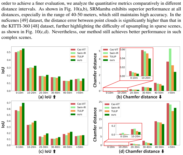
- The method maintains higher accuracy at long range than the baselines, with the largest measured advantage in the 40-50 meter interval.
Reading between the lines
- The paper does not test temporal fusion; if the synthetic-downsampling assumption holds, the same range-image pipeline could plausibly average consecutive low-beam scans to fill holes before super-resolution, which could further reduce drift.
- A matched-capacity ablation with the same U-Net depth and training schedule but a Transformer block instead of the SS2D block, both fed the same Hough-voting inputs, would isolate how much of the gain comes from the Mamba backbone rather than the hole-filling preprocessing.
- Because the output is a range image, the method should adapt to other spinning LiDAR beam counts and possibly to solid-state sensors whose scans can be re-projected, but real-sensor evaluation is needed to confirm transfer.
- The paper reports reconstruction metrics only; testing SRMamba-upsampled clouds in downstream detection or segmentation would show whether the geometric gains translate into perception gains.
Signed reviews
Editorial analysis
A structured set of objections, weighed in public.
Referee Report
Summary. The paper proposes SRMamba, a range-image-based LiDAR point cloud super-resolution method. The pipeline projects a sparse point cloud to a range image, applies Hough Voting and a Hole Compensation mechanism to reduce horizontal holes, then uses a Mamba-based asymmetric U-Net with multi-directional scanning to produce a high-resolution range image before back-projecting to 3D. Experiments on KITTI-360 and nuScenes with simulated 4x beam downsampling compare SRMamba against Cas-ViT, SwinIR, and TULIP using IoU, Chamfer Distance, and MAE. The authors report consistent quantitative gains and qualitative improvements, and claim that the method better preserves 3D structure under novel viewpoints.
Significance. If the claims hold, the paper would make a useful contribution: it combines a state-space model with range-view super-resolution for LiDAR point clouds, addresses hole artifacts with a simple preprocessing mechanism, and reports experiments on two public datasets with a published baseline comparison. The explicit failure-case discussion is also commendable. However, the significance is currently tempered by the evaluation protocol: the central superiority claim rests on synthetic beam downsampling, the novel-view advantage has no quantitative evidence, and the reported margins lack error bars. These issues make the contribution plausible but not yet established.
major comments (3)
- [Section 4.1 (Dataset) and Tables 1-2] The load-bearing evaluation condition is the statement that 'the two datasets are processed with 4 times downsampling to simulate sparse point cloud inputs.' All quantitative results (Tables 1-2 and Fig. 10) are obtained on this synthetic task: KITTI-360's HDL-64E is reduced to 16 beams and nuScenes's HDL-32E to 8 beams by row dropping. Real low-beam LiDAR sensors have different elevation angles, nonuniform beam spacing, and different noise and occlusion characteristics, so a subset of a dense sensor's beams is not the same as a genuine sparse sensor input. Without an experiment on real sparse LiDAR data, or at minimum a much stronger argument that the synthetic task transfers, the abstract's claim of 'significant superiority' remains conditional on the simulation being faithful.
- [Section 4.4 (Qualitative Evaluation, Fig. 9) and abstract] The paper's central motivation and abstract emphasize reconstruction under novel views, but the novel-view advantage is demonstrated only qualitatively in Fig. 9. No quantitative metric is reported for viewpoints off the projection plane, even though the introduction states that the method 'address[es] the key challenge of recovering the 3D spatial structure of point clouds from novel views.' A quantitative evaluation at rotated viewpoints (e.g., CD or F-score after transforming the reconstruction) is needed to support this claim.
- [Section 4.4.2 and Tables 1-2] The quantitative comparison reports only single validation-split numbers without error bars, repeated runs, or any statistical significance test. Because the reported margins are moderately sized (e.g., IoU 0.4548 vs 0.4152 for TULIP on KITTI-360), a reader cannot tell whether these differences are stable or within run-to-run noise. The validation-only protocol (Section 4.1) also leaves open the risk of overfitting to the selected scans; held-out test splits or cross-validation would strengthen the claim.
minor comments (5)
- [Abstract and Section 4.1] The abstract says experiments were conducted on 'SemanticKITTI,' but Section 4.1 uses KITTI-360. This is a factual mismatch that should be corrected.
- [Section 4.4.2 and Table 1] The text states that SRMamba 'achieves better performance in terms of all metrics,' but on KITTI-360 SRMamba-L has MAE 0.0048 while SRMamba-T has MAE 0.0044, so the larger model is worse on MAE. The sentence should be qualified.
- [Section 4.3 (Experimental Details)] The phrase '600 ephemeral sessions' is unclear; it presumably means 600 training epochs. Also, the training/test protocol does not state whether the baselines (Cas-ViT, SwinIR, TULIP) were trained under identical conditions, which is important for a fair comparison.
- [Section 3.2.2, Eq. (6)] The notation for Δb and 𝜑b says they are 1D arrays of length H, but in Eq. (6) they are used as though each point has a corresponding value. Please clarify the indexing and whether the argmin is over the beam list.
- [Table 4] The depth ablation shows SRMamba-M with MAE 0.0055, worse than SRMamba-S (0.0044) and SRMamba-T (0.0044), while CD and IoU improve monotonically. The text says the results 'validate the effectiveness of the proposed method for multi-layer feature extraction,' but the trend is not monotonic in all metrics and should be discussed.
Circularity Check
No circularity found; SRMamba is a standard supervised super-resolution pipeline trained and evaluated on held-out public LiDAR scans.
full rationale
The derivation chain is self-contained. The network takes a sparse point cloud, projects it to a range image via sensor-calibration equations (Eq. 6), fills holes with local pooling (Eq. 7), passes features through VSS blocks and an asymmetric U-Net, and up-samples with PixelShuffle. No parameter in these equations is fitted to the evaluation targets; the learned weights are optimized on training scans and assessed on separate validation scans from KITTI-360 and nuScenes. The 4x downsampling protocol in Sec. 4.1 ('the two datasets are processed with 4 times downsampling to simulate sparse point cloud inputs') creates the input/target pairs for supervised learning and is not a self-referential definition of success. The only self-citation (ref. 4, DeepMapping2) appears in the introduction's list of LiDAR applications and is not load-bearing for the method or results. The reviewer's concern that synthetic beam-dropping may not transfer to real low-beam sensors is a legitimate external-validity question, but it is not circularity under the stated criteria.
Assumptions & free parameters
free parameters (4)
- Upsampling factor scales =
4
- Hole compensation window shape =
3x1 (vertical)
- Network depth of SRMamba-L =
[2,2,27,2]
- Simulated input range image height =
16 (KITTI-360), 8 (nuScenes)
assumptions (4)
- standard math Zero-order hold discretization of the continuous linear state space model (Eqs. 1-4) is the correct discretization for the sequence model.
- domain assumption The spherical projection with per-beam vertical and horizontal correction arrays (Delta_b, phi_b) in Eq. 6 correctly maps LiDAR points to range image pixels without loss of essential geometry.
- domain assumption Subsampling an existing dense LiDAR scan by a factor of 4 along the beam dimension reproduces the statistics of a true low-beam LiDAR input.
- domain assumption Chamfer Distance, voxel IoU, and range-image MAE are adequate proxies for geometric fidelity in novel viewpoints.
Cite this review
Pith. "Pith review of SRMamba: Mamba for Super-Resolution of LiDAR Point Clouds." pith.science (2026). https://pith.science/paper/6HL3IC2W
@misc{pith2026250510601,
  author       = {Pith},
  title        = {Pith review of: SRMamba: Mamba for Super-Resolution of LiDAR Point Clouds},
  year         = {2026},
  howpublished = {\url{https://pith.science/paper/6HL3IC2W}},
  note         = {Machine review of arXiv:2505.10601}
}
read the original abstract
In recent years, range-view-based LiDAR point cloud super-resolution techniques attract significant attention as a low-cost method for generating higher-resolution point cloud data. However, due to the sparsity and irregular structure of LiDAR point clouds, the point cloud super-resolution problem remains a challenging topic, especially for point cloud upsampling under novel views. In this paper, we propose SRMamba, a novel method for super-resolution of LiDAR point clouds in sparse scenes, addressing the key challenge of recovering the 3D spatial structure of point clouds from novel views. Specifically, we implement projection technique based on Hough Voting and Hole Compensation strategy to eliminate horizontally linear holes in range image. To improve the establishment of long-distance dependencies and to focus on potential geometric features in vertical 3D space, we employ Visual State Space model and Multi-Directional Scanning mechanism to mitigate the loss of 3D spatial structural information due to the range image. Additionally, an asymmetric U-Net network adapts to the input characteristics of LiDARs with different beam counts, enabling super-resolution reconstruction for multi-beam point clouds. We conduct a series of experiments on multiple challenging public LiDAR datasets (SemanticKITTI and nuScenes), and SRMamba demonstrates significant superiority over other algorithms in both qualitative and quantitative evaluations.
Figures


Figures from the paper (10 more)




Reference graph
Works this paper leans on
-
[1]
Rangeldm: Fast realistic lidar point cloud generation,
Q. Hu, Z. Zhang, and W. Hu, “Rangeldm: Fast realistic lidar point cloud generation,” inEuropean Conference on Computer Vision,(Springer, 2024), pp. 115–135
work page 2024
-
[2]
Hvnet: Hybrid voxel network for lidar based 3d object detection,
M. Ye, S. Xu, and T. Cao, “Hvnet: Hybrid voxel network for lidar based 3d object detection,” in2020 IEEE/CVF Conference on Computer Vision and Pattern Recognition (CVPR),(2020), pp. 1628–1637
work page 2020
-
[3]
Panoptic-polarnet: Proposal-free lidar point cloud panoptic segmentation,
Z. Zhou, Y. Zhang, and H. Foroosh, “Panoptic-polarnet: Proposal-free lidar point cloud panoptic segmentation,” in 2021 IEEE/CVF Conference on Computer Vision and Pattern Recognition (CVPR),(2021), pp. 13189–13198
work page 2021
-
[4]
Deepmapping2: Self-supervised large-scale lidar map optimization,
C. Chen, X. Liu, Y. Li,et al., “Deepmapping2: Self-supervised large-scale lidar map optimization,” in2023 IEEE/CVF Conference on Computer Vision and Pattern Recognition (CVPR),(2023), pp. 9306–9316
work page 2023
-
[5]
Fast-lio2: Fast direct lidar-inertial odometry,
W. Xu, Y. Cai, D. He,et al., “Fast-lio2: Fast direct lidar-inertial odometry,” IEEE Trans. on Robotics38, 2053–2073 (2022)
work page 2022
-
[6]
Vpl-slam: a vertical line supported point line monocular slam system,
Q. Chen, Y. Cao, J. Hou,et al., “Vpl-slam: a vertical line supported point line monocular slam system,” IEEE Trans. on Intell. Transp. Syst. (2024)
work page 2024
-
[7]
J. Yue, W. Wen, J. Han, and L.-T. Hsu, “3d point clouds data super resolution-aided lidar odometry for vehicular positioning in urban canyons,” IEEE Trans. on Veh. Technol.70, 4098–4112 (2021)
work page 2021
-
[8]
Pugeo-net: A geometry-centric network for 3d point cloud upsampling,
Y. Qian, J. Hou, S. Kwong, and Y. He, “Pugeo-net: A geometry-centric network for 3d point cloud upsampling,” in European conference on computer vision,(Springer, 2020), pp. 752–769
work page 2020
Show all 53 references
-
[9]
Pu-net: Point cloud upsampling network,
L. Yu, X. Li, C.-W. Fu,et al., “Pu-net: Point cloud upsampling network,” inProceedings of the IEEE conference on computer vision and pattern recognition,(2018), pp. 2790–2799
2018
-
[10]
Patch-based progressive 3d point set upsampling,
W. Yifan, S. Wu, H. Huang,et al., “Patch-based progressive 3d point set upsampling,” inProceedings of the IEEE/CVF conference on computer vision and pattern recognition,(2019), pp. 5958–5967
2019
-
[11]
Edge-aware point set resampling,
H. Huang, S. Wu, M. Gong,et al., “Edge-aware point set resampling,” ACM transactions on graphics (TOG)32, 1–12 (2013)
2013
-
[12]
Point cloud upsampling via disentangled refinement,
R. Li, X. Li, P.-A. Heng, and C.-W. Fu, “Point cloud upsampling via disentangled refinement,” inProceedings of the IEEE/CVF conference on computer vision and pattern recognition,(2021), pp. 344–353
2021
-
[13]
Simulation-based lidar super-resolution for ground vehicles,
T. Shan, J. Wang, F. Chen,et al., “Simulation-based lidar super-resolution for ground vehicles,” Robotics Auton. Syst. 134, 103647 (2020)
2020
-
[14]
Enhancingthereliabilityoflidarpointcloudsampling: Acolorizationandsuper-resolution approach based on lidar-generated images,
S.Ha,H.Du,X.Yu, etal.,“Enhancingthereliabilityoflidarpointcloudsampling: Acolorizationandsuper-resolution approach based on lidar-generated images,” arXiv preprint arXiv:2409.11532 (2024)
2024 arXiv
-
[16]
Single image super-resolution via a holistic attention network,
B. Niu, W. Wen, W. Ren,et al., “Single image super-resolution via a holistic attention network,” inComputer Vision–ECCV 2020: 16th European Conference, Glasgow, UK, August 23–28, 2020, Proceedings, Part XII 16, (Springer, 2020), pp. 191–207
2020
-
[17]
Image super-resolution using very deep residual channel attention networks,
Y. Zhang, K. Li, K. Li,et al., “Image super-resolution using very deep residual channel attention networks,” in Proceedings of the European conference on computer vision (ECCV),(2018), pp. 286–301
2018
-
[18]
A deep journey into super-resolution: A survey,
S. Anwar, S. Khan, and N. Barnes, “A deep journey into super-resolution: A survey,” ACM computing surveys (CSUR) 53, 1–34 (2020)
2020
-
[19]
Attention is all you need,
A. Vaswani, N. Shazeer, N. Parmar,et al., “Attention is all you need,” Adv. neural information processing systems30 (2017)
2017
-
[20]
Vmamba: Visual state space model,
Y. Liu, Y. Tian, Y. Zhao,et al., “Vmamba: Visual state space model,” Adv. neural information processing systems 37, 103031–103063 (2024)
2024
-
[21]
Rsmamba: Remote sensing image classification with state space model,
K. Chen, B. Chen, C. Liu,et al., “Rsmamba: Remote sensing image classification with state space model,” IEEE Geosci. Remote. Sens. Lett.21, 1–5 (2024)
2024
-
[22]
Classifying cervical oct images using masked autoencoders with vmamba,
Q. Wang, Y. Pei, J. Wang, and Y. Ma, “Classifying cervical oct images using masked autoencoders with vmamba,” in 2024 IEEE International Conference on Bioinformatics and Biomedicine (BIBM),(2024), pp. 2526–2533
2024
-
[23]
Face mamba: A facial emotion analysis network based on vmamba*,
L. Li, Q. Sun, L. Zhao,et al., “Face mamba: A facial emotion analysis network based on vmamba*,” in2024 7th International Conference on Machine Learning and Natural Language Processing (MLNLP),(2024), pp. 1–5
2024
-
[24]
Computing and rendering point set surfaces,
M. Alexa, J. Behr, D. Cohen-Or,et al., “Computing and rendering point set surfaces,” IEEE Trans. on visualization computer graphics9, 3–15 (2003)
2003
-
[25]
Parameterization-free projection for geometry reconstruction,
Y. Lipman, D. Cohen-Or, D. Levin, and H. Tal-Ezer, “Parameterization-free projection for geometry reconstruction,” ACM Trans. on Graph. (ToG)26, 22–es (2007)
2007
-
[26]
Consolidation of unorganized point clouds for surface reconstruction,
H. Huang, D. Li, H. Zhang,et al., “Consolidation of unorganized point clouds for surface reconstruction,” ACM transactions on graphics (TOG)28, 1–7 (2009)
2009
-
[27]
Efficient deep super-resolution of voxelized point cloud in geometry compression,
K. Matsuzaki and S. Komorita, “Efficient deep super-resolution of voxelized point cloud in geometry compression,” IEEE Sensors J.23, 1328–1342 (2023)
2023
-
[28]
Hierarchical attention feature fusion and refinement network for point cloud upsampling,
Y. Zhang, S. Lin, F. Zhou, and R. Wang, “Hierarchical attention feature fusion and refinement network for point cloud upsampling,” in2024 IEEE International Conference on Multimedia and Expo (ICME),(2024), pp. 1–8
2024
-
[29]
Point cloud upsampling via a coarse-to-fine network,
Y. Wang, S. Wang, and L. Sun, “Point cloud upsampling via a coarse-to-fine network,” inConference on Multimedia Modeling,(2022), pp. 467–478
2022
-
[30]
Point cloud upsampling via disentangled refinement,
R. Li, X. Li, P.-A. Heng, and C.-W. Fu, “Point cloud upsampling via disentangled refinement,” in2021 IEEE/CVF Conference on Computer Vision and Pattern Recognition (CVPR),(2021), pp. 344–353
2021
-
[31]
Hals: Aheight-awarelidarsuper-resolutionframeworkforautonomous driving,
G.Eskandar,S.Sudarsan,K.Guirguis, etal.,“Hals: Aheight-awarelidarsuper-resolutionframeworkforautonomous driving,” arXiv preprint arXiv:2202.03901 (2022)
2022 arXiv
-
[32]
Fbrnn: feedbackrecurrentneuralnetworkforextremeimagesuper-resolution,
J.Lee,J.Park, K.Lee, etal., “Fbrnn: feedbackrecurrentneuralnetworkforextremeimagesuper-resolution,” in 2020 IEEE/CVF Conference on Computer Vision and Pattern Recognition Workshops (CVPRW),(2020), pp. 2021–2028
2020
-
[33]
Image super-resolution with cross-scale non-local attention and exhaustive self- exemplars mining,
Y. Mei, Y. Fan, Y. Zhou,et al., “Image super-resolution with cross-scale non-local attention and exhaustive self- exemplars mining,” in2020 IEEE/CVF Conference on Computer Vision and Pattern Recognition (CVPR),(2020), pp. 5689–5698
2020
-
[34]
Apointclouddensityenhancementmethodbasedonsuper-resolutionconvolutional neural network,
H.Meng,Y.Han,J.Chen, etal.,“Apointclouddensityenhancementmethodbasedonsuper-resolutionconvolutional neural network,” in2019 IEEE International Conference on Unmanned Systems and Artificial Intelligence (ICUSAI), (IEEE, 2019), pp. 8–12
2019
-
[35]
Lsr-ribnet: A novel lidar super-resolution model for scene semantic segmentation in outdoor environments,
G. He, Y. Liu, and Q. Tan, “Lsr-ribnet: A novel lidar super-resolution model for scene semantic segmentation in outdoor environments,” in2023 13th International Conference on Information Science and Technology (ICIST), (2023), pp. 129–135
2023
-
[36]
Up-sampling method for low-resolution lidar point cloud to enhance 3d object detection in an autonomous driving environment,
J. You and Y.-K. Kim, “Up-sampling method for low-resolution lidar point cloud to enhance 3d object detection in an autonomous driving environment,” Sensors23, 322 (2022)
2022
-
[37]
Channel attention based network for lidar super-resolution,
K. Chen, C. Liu, and Y. Ou, “Channel attention based network for lidar super-resolution,” in2021 China Automation Congress (CAC),(IEEE, 2021), pp. 5458–5463
2021
-
[38]
Tulip: Transformer for upsampling of lidar point clouds,
B. Yang, P. Pfreundschuh, R. Siegwart,et al., “Tulip: Transformer for upsampling of lidar point clouds,” in2024 IEEE/CVF Conference on Computer Vision and Pattern Recognition (CVPR),(2024), pp. 15354–15364
2024
-
[39]
U-mamba: Enhancing long-range dependency for biomedical image segmentation,
J. Ma, F. Li, and B. Wang, “U-mamba: Enhancing long-range dependency for biomedical image segmentation,” arXiv preprint arXiv:2401.04722 (2024)
2024 arXiv
-
[40]
Weak-mamba-unet: Visual mamba makes cnn and vit work better for scribble-based medical image segmentation,
Z. Wang and C. Ma, “Weak-mamba-unet: Visual mamba makes cnn and vit work better for scribble-based medical image segmentation,” arXiv preprint arXiv:2402.10887 (2024)
2024 arXiv
-
[41]
Mamba: Linear-time sequence modeling with selective state spaces,
A. Gu and T. Dao, “Mamba: Linear-time sequence modeling with selective state spaces,” arXiv preprint arXiv:2312.00752 (2023)
2023 arXiv
-
[42]
Vision mamba: A comprehensive survey and taxonomy,
X. Liu, C. Zhang, and L. Zhang, “Vision mamba: A comprehensive survey and taxonomy,” arXiv preprint arXiv:2405.04404 (2024)
2024 arXiv
-
[43]
Frnet: Frustum-range networks for scalable lidar segmentation,
X. Xu, L. Kong, H. Shuai, and Q. Liu, “Frnet: Frustum-range networks for scalable lidar segmentation,” IEEE Trans. on Image Process.34, 2173–2186 (2025)
2025
-
[44]
Uniseg: A unified multi-modal lidar segmentation network and the openpcseg codebase,
Y. Liu, R. Chen, X. Li,et al., “Uniseg: A unified multi-modal lidar segmentation network and the openpcseg codebase,” inProceedingsoftheIEEE/CVFInternationalConferenceonComputerVision, (2023), pp.21662–21673
2023
-
[45]
Attention u-net: Learning where to look for the pancreas,
O. Oktay, J. Schlemper, L. L. Folgoc,et al., “Attention u-net: Learning where to look for the pancreas,” arXiv preprint arXiv:1804.03999 (2018)
2018 arXiv
-
[46]
Mixed transformer u-net for medical image segmentation,
H. Wang, S. Xie, L. Lin,et al., “Mixed transformer u-net for medical image segmentation,” inICASSP 2022-2022 IEEE international conference on acoustics, speech and signal processing (ICASSP),(IEEE, 2022), pp. 2390–2394
2022
-
[47]
Deep residual learning for image recognition,
K. He, X. Zhang, S. Ren, and J. Sun, “Deep residual learning for image recognition,” inProceedings of the IEEE conference on computer vision and pattern recognition,(2016), pp. 770–778
2016
-
[48]
Kitti-360: A novel dataset and benchmarks for urban scene understanding in 2d and 3d,
Y. Liao, J. Xie, and A. Geiger, “Kitti-360: A novel dataset and benchmarks for urban scene understanding in 2d and 3d,” IEEE Trans. on Pattern Anal. Mach. Intell.45, 3292–3310 (2022)
2022
-
[49]
Panoptic nuscenes: A large-scale benchmark for lidar panoptic segmentation and tracking,
W. K. Fong, R. Mohan, J. V. Hurtado,et al., “Panoptic nuscenes: A large-scale benchmark for lidar panoptic segmentation and tracking,” IEEE Robotics Autom. Lett.7, 3795–3802 (2022)
2022
-
[50]
Pcn: Point completion network,
W. Yuan, T. Khot, D. Held,et al., “Pcn: Point completion network,” in2018 international conference on 3D vision (3DV),(IEEE, 2018), pp. 728–737
2018
-
[51]
Implicit lidar network: Lidar super-resolution via interpolation weight prediction,
Y. Kwon, M. Sung, and S.-E. Yoon, “Implicit lidar network: Lidar super-resolution via interpolation weight prediction,” in2022 international conference on robotics and automation (ICRA),(IEEE, 2022), pp. 8424–8430
2022
-
[52]
Decoupled weight decay regularization,
I. Loshchilov and F. Hutter, “Decoupled weight decay regularization,” arXiv preprint arXiv:1711.05101 (2017)
2017 arXiv
-
[53]
Cas-vit: Convolutional additive self-attention vision transformers for efficient mobile applications,
T. Zhang, L. Li, Y. Zhou,et al., “Cas-vit: Convolutional additive self-attention vision transformers for efficient mobile applications,” arXiv preprint arXiv:2408.03703 (2024)
2024 arXiv
-
[54]
Swinir: Image restoration using swin transformer,
J. Liang, J. Cao, G. Sun,et al., “Swinir: Image restoration using swin transformer,” inProceedings of the IEEE/CVF international conference on computer vision,(2021), pp. 1833–1844
2021
Reviewed August 15, 2026 · model on record in the stance chip above.
Discussion (0). Continue with ORCID to comment.