REVIEW 5 major objections 7 minor 1 cited by
VLM-Guided Visual Place Recognition for Planet-Scale Geo-Localization
T0 review · 5 major / 7 minor · reviewed 2026-08-06 · deepseek-v4-flash
Pith's one-line read This paper claims that planet-scale single-image geo-localization is achievable without task-specific training by letting a vision-language model's rough coordinate estimate narrow a visual-place-recognition retrieval to a submap, then…
desk verdict Useful training-free VLM+VPR hybrid for geo-localization; solid ablations but missing VLM-only baseline and coverage oracle cap the SOTA claims. read the letter →
The pith
A machine-rendered reading of the paper's core claim, the machinery that carries it, and where it could break.
The reading
What carries the argument
The load-bearing mechanism is the geographic prior as a search-space filter. A VLM produces approximate coordinates for the query; those coordinates select one of 100 K-means clusters (or one country) of the reference database, so retrieval only compares the query descriptor against descriptors in that submap. Then a distance-based re-ranking sorts the top retrieved images by haversine distance to the prior, picking the closest geographically plausible match rather than the most visually similar one.
What would settle it
Take a set of queries whose true coordinates are known and check whether any MP-16 image exists within the selected submap's geographic extent of each query. If queries with no nearby reference image still localize correctly, the gains cannot come from retrieval; conversely, if accuracy collapses on those queries, the method's success is bounded by reference coverage and VLM prior accuracy, which can be measured directly.
Extended reading notes
Core claim
On the paper's own terms, the central discovery is that the failure modes of VLMs and retrieval-based visual place recognition are complementary, so composing them improves geo-localization. Using a VLM (GPT-4v or Gemini-1.5-Pro) to produce a coordinate prior, the method partitions the 4.1-million-image MP-16 reference set into 100 cluster-based submaps (or country-level submaps), retrieves the nearest visual neighbors only inside the submap containing the prior, and then re-ranks the top candidates by haversine distance to the prior. The best configuration (EigenPlaces descriptors, cluster submaps, GPT-4v prior, re-ranking) reaches 24.89% street-level and 52.32% city-level accuracy on IM2GPS, 18.62% and 45.65% on IM2GPS3k, and 0.48% and 10.28% on GWS15k, surpassing the prior methods reported in the paper at nearly every spatial scale. The authors attribute the gains to submap restriction plus re-ranking rather than to the choice of VLM or VPR method, since the pattern holds across pairings.
Load-bearing premise
The method assumes that the reference database has images geographically close to the true location of every query, and that the VLM's coordinate guess is close enough that the true location falls inside the submap selected by that guess; if the guess is off by more than the submap's extent, or no reference image exists near the truth, retrieval and re-ranking cannot recover.
Editorial extensions
If this is right
- The pipeline reaches higher accuracy than the reported prior baselines on all three datasets at most resolutions, with the largest gain at city level on IM2GPS (up to 13.52 percentage points over the previous best).
- Submap restriction alone accounts for a large share of the improvement: on IM2GPS3k, CosPlace with cluster submaps jumps from 15.22% to 43.98% accuracy at 25 km.
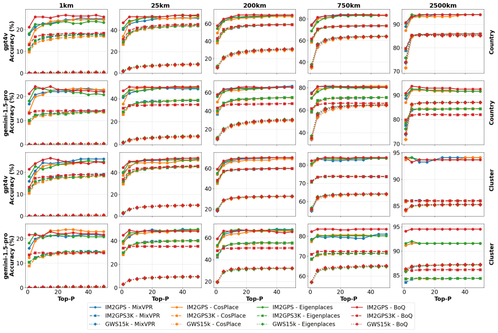
- Re-ranking adds a consistent further gain over submap-only retrieval, saturating when about 50 candidates are considered, after which additional candidates contribute little.
- Because the framework uses off-the-shelf VLM and VPR models with no task-specific training, the same components can be swapped for newer models without retraining.
Reading between the lines
- A direct test the paper does not run: measure the VLM prior's standalone accuracy and compare it with the final hybrid accuracy; if retrieval only adds value when the prior is already inside the submap, the method's ceiling is set by VLM spatial reasoning, not by retrieval.
- The sharp drop on GWS15k (0.48% at street level) suggests that the method inherits the geographic bias of the MP-16 reference set; a balanced reference database would be a stronger test of the approach.
- The same submap-prior plus re-ranking recipe could be applied to other retrieval tasks with imperfect priors, such as audio or text localization, wherever a coarse but semantically informed guess can shrink the search space.
- Because the method returns a retrieved image rather than a bare coordinate, it offers a built-in visual verification channel that pure coordinate prediction lacks; this could matter in robotics and disaster response.
Editorial analysis
A structured set of objections, weighed in public.
Referee Report
Summary. The paper proposes a hybrid, training-free pipeline for single-image planet-scale geo-localization. A commercial VLM (GPT-4v or Gemini-1.5-Pro) is prompted to predict approximate GPS coordinates (the prior). The MP-16 reference database is partitioned into geographically coherent submaps, either by country or by K-means clustering (K=100). A VPR model (CosPlace, MixVPR, EigenPlaces, or BoQ) retrieves the top-p visually similar reference images from the submap selected by the prior, and the final prediction is the retrieved image whose GPS tag is closest in haversine distance to the VLM prior. Experiments on IM2GPS, IM2GPS3k, and a reproduced GWS15k report consistent gains over VPR-only retrieval and state-of-the-art results vs. prior geo-localization methods, with the best configuration being EigenPlaces + cluster submaps + GPT-4v re-ranking.
Significance. If the claims hold, this is a practically attractive contribution: it combines the semantic world-knowledge of VLMs with the robustness of VPR in a modular, task-training-free framework, and it shows large absolute gains over VPR-only baselines (e.g., Table 1: CosPlace from 7.14% to 18.42% at 1 km on IM2GPS3k). The cross-product of two VLMs, four VPR methods, two submap strategies, and a re-ranking step is a genuinely useful ablation. However, the central SOTA claim is currently under-supported: the standalone accuracy of the VLM is never measured, the upper bound imposed by MP-16 reference coverage is not quantified, query-reference overlap is not audited, and no error bars or significance tests accompany small differences. These gaps must be closed before the headline 'consistently outperforms prior SOTA' can be fairly evaluated.
major comments (5)
- [Section 3.3, Eq. (8); Section 5.1] The final prediction is always the GPS tag of an MP-16 reference image selected by minimum haversine distance to the VLM prior. Consequently, the retrieval step's independent contribution is never isolated: if the prior is accurate and the submap happens to contain a reference image near the prior, re-ranking alone can account for most of the accuracy. Report the standalone coordinate-prediction accuracy of GPT-4v and Gemini-1.5-Pro on all three benchmarks using the same LTM prompt and thresholds (e.g., a VLM-only row in Table 2), together with an oracle retrieval ceiling (the best accuracy achievable by choosing, for each query, the MP-16 image closest to the true location). Without these, the paper cannot support its claim that VLM-guided VPR—rather than the VLM prior itself—yields the reported gains.
- [Section 4; Table 2] No reference-coverage oracle or duplicate audit is reported. Because every prediction comes from MP-16, the method cannot be correct at a given threshold unless MP-16 contains an image within that radius of the query's true location. The classification baselines in Table 2 (PlaNet, GeoDecoder, PIGEOTTO, etc.) do not depend on reference coverage, so the SOTA comparison is only meaningful if the MP-16 ceiling is quantified. Compute the per-query distance to the nearest MP-16 image and report oracle accuracy at all five thresholds, and check for near-duplicate or same-source images between IM2GPS/IM2GPS3k (Flickr) and MP-16 (Flickr). Without this audit, the gains over prior methods may be inflated by query-reference overlap rather than by VLM-guided retrieval.
- [Section 5, Tables 1 and 2] No error bars, confidence intervals, or significance tests are reported. Several headline differences are small (e.g., Table 1: CosPlace vs. EigenPlaces at 25 km on IM2GPS3k differ by 0.24 percentage points; Table 2: ours vs. PIGEOTTO on GWS15k at 2500 km differ by 0.15 percentage points), and commercial VLM API calls are stochastic. Report means and standard deviations over repeated VLM calls or bootstrap resampling of queries, and apply a paired test (e.g., McNemar or bootstrap) to the comparisons that support the 'consistently outperforms' claim. The absence of variability information makes it impossible to judge whether the claimed improvements are reliable.
- [Section 3.1, Eq. (1); Section 5.4] The hyperparameters K=100 (number of clusters) and p (number of retrieved candidates) are introduced without a validation procedure, and the BoQ feature dimension (16,384) is fixed by the smallest available configuration without discussion. K is load-bearing because cluster-based submaps are core to the method, and p=50 is selected from Fig. 2 without a held-out split or sensitivity analysis. Provide a sensitivity study (e.g., K in {10, 50, 200, 500}; p in {10, 50, 100, 200}) on a validation set and justify the chosen values. If performance saturates, state the plateau explicitly.
- [Section 4] The GWS15k benchmark is not publicly available, and the paper states only that it was 'reproduced following the instructions provided in Clark et al. [2023]'. No details are given about the random seeds, the city selection process, the construction of the 5 km radius, or how the reproduction was verified against the original benchmark. Since Table 2 compares against published GWS15k numbers from prior work, any difference between the reproduced and original splits invalidates the comparison. Release the reproduced query set and ground-truth coordinates (or a hash), document the exact sampling protocol, and verify that the reproduced baselines match published results on the same split.
minor comments (7)
- [Abstract; Section 5.5] The numerical claims are inconsistent: the abstract reports gains 'up to 4.51% at street level and 13.52% at city level', while Section 5.5 reports +4.1% at street and +3.8% at city on IM2GPS and +10.3% at city on IM2GPS3k; Table 2 does not contain 13.52%. Please reconcile these numbers using one consistent set of prior-comparison baselines.
- [Section 5.5] The text states a 'marginal drop of 0.18% at the 1 km resolution' on GWS15k, but Table 2 shows ours 0.48 vs. PIGEOTTO 0.79, a drop of 0.31 percentage points. The difference between the stated and tabulated values should be corrected.
- [Section 1; Abstract] The introduction reports 'up to 4% improvement on Im2GPS, 10.31% on Im2GPS3k, and 2.6% on GWS15k', which differ from the abstract and Section 5.5. Use one consistent set of headline numbers throughout the paper.
- [Section 3.2 vs. Figure 1] Section 3.2 says the prior is used to select 'the most relevant submaps' (plural), while Figure 1 says 'select a relevant sub-map' (singular). Clarify whether one or multiple submaps are searched, and how the submap is determined from the VLM coordinates (e.g., nearest cluster centroid or containing country).
- [Section 5.4; Figure 2] The text discusses 're-ranking accuracy' but the figure caption describes 'top-p retrieval accuracy'; clarify which quantity is plotted and how it is computed.
- [Table 1 caption] For BoQ, the global-retrieval rows are missing ('retrieval was only performed with submaps due to high feature dimensionality constraints'). State this limitation in the main text and discuss whether it affects the fairness of the BoQ comparisons.
- [Section 3.2] The prompt used for VLM prior estimation is omitted 'for brevity', but it is essential for reproducibility; include the full LTM prompt in an appendix or supplemental material.
Circularity Check
No circularity found: the VLM prior is an external model input, and the final selection in Eq. (8) is the paper's explicitly stated algorithm rather than a hidden equivalence to its own fitted terms.
full rationale
The derivation chain is not circular. The VLM generates a geographic prior from the query image; this prior selects a submap, and the VPR descriptor retrieves top-p candidates. Eq. (7)-(8) then return the retrieved MP-16 image with minimum haversine distance to that prior. Thus the final GPS is a projection of an external, black-box VLM estimate onto the reference set, not a quantity fitted from the benchmark or defined in terms of the paper's own output. The self-citations to Waheed et al. [2025] support only motivational claims about VLM hallucination and lack of interpretability; they are not load-bearing in the derivation, and no uniqueness theorem or fitted parameter is invoked. The identified concerns - unmeasured MP-16 query-reference coverage, possible duplicate queries, and the absence of a VLM-only baseline - are potential benchmark-validity or attribution issues, but they are not circular reasoning under the definitions used here.
Assumptions & free parameters
free parameters (3)
- K (number of clusters) =
100
- p (number of top retrieval candidates) =
50 (implied)
- Feature dimension for BoQ =
16384
assumptions (4)
- domain assumption The MP-16 reference set contains images geographically close to each test query.
- domain assumption The VLM prior is accurate enough that the true location falls in the selected submap.
- ad hoc to paper K-means on raw latitude/longitude coordinates produces geographically coherent submaps.
- domain assumption Re-ranking by minimum haversine distance to the VLM prior improves or maintains accuracy.
Cite this review
Pith. "Pith review of VLM-Guided Visual Place Recognition for Planet-Scale Geo-Localization." pith.science (2026). https://pith.science/paper/V2M6OV5N
@misc{pith2026250717455,
  author       = {Pith},
  title        = {Pith review of: VLM-Guided Visual Place Recognition for Planet-Scale Geo-Localization},
  year         = {2026},
  howpublished = {\url{https://pith.science/paper/V2M6OV5N}},
  note         = {Machine review of arXiv:2507.17455}
}
read the original abstract
Geo-localization from a single image at planet scale (essentially an advanced or extreme version of the kidnapped robot problem) is a fundamental and challenging task in applications such as navigation, autonomous driving and disaster response due to the vast diversity of locations, environmental conditions, and scene variations. Traditional retrieval-based methods for geo-localization struggle with scalability and perceptual aliasing, while classification-based approaches lack generalization and require extensive training data. Recent advances in vision-language models (VLMs) offer a promising alternative by leveraging contextual understanding and reasoning. However, while VLMs achieve high accuracy, they are often prone to hallucinations and lack interpretability, making them unreliable as standalone solutions. In this work, we propose a novel hybrid geo-localization framework that combines the strengths of VLMs with retrieval-based visual place recognition (VPR) methods. Our approach first leverages a VLM to generate a prior, effectively guiding and constraining the retrieval search space. We then employ a retrieval step, followed by a re-ranking mechanism that selects the most geographically plausible matches based on feature similarity and proximity to the initially estimated coordinates. We evaluate our approach on multiple geo-localization benchmarks and show that it consistently outperforms prior state-of-the-art methods, particularly at street (up to 4.51%) and city level (up to 13.52%). Our results demonstrate that VLM-generated geographic priors in combination with VPR lead to scalable, robust, and accurate geo-localization systems.
Figures


Figures from the paper (1 more)

Forward citations
Cited by 1 Pith paper
-
Breaking D\'ej\`a Vu: Independent Auditing of Visual Place Recognition through Vision-Language Reasoning
VLM-based post-retrieval auditing of visual place recognition raises recall@1 by 13.6% on average while cutting false accepts to 12% and holding precision above 95%.
Reference graph
Works this paper leans on
-
[2023]
Granular privacy control for geolocation with vision language models
Ethan Mendes, Yang Chen, James Hays, Sauvik Das, Wei Xu, and Alan Ritter. Granular privacy control for geolocation with vision language models. In Yaser Al-Onaizan, Mohit Bansal, and Yun-Nung Chen, ed- itors,Proceedings of the 2024 Conference on Empir- ical Methods in Natural Language Processing, pages 17240–17292, Miami, Florida, USA, November
work page 2024
-
[1]
Gpt-4 technical report.arXiv preprint arXiv:2303.08774,
Josh Achiam, Steven Adler, Sandhini Agarwal, Lama Ahmad, Ilge Akkaya, Florencia Leoni Aleman, Diogo Almeida, Janko Altenschmidt, Sam Altman, Shyamal Anadkat, et al. Gpt-4 technical report.arXiv preprint arXiv:2303.08774,
-
[6]
Sania Waheed, Bruno Ferrarini, Michael Milford, Sar- vapali D Ramchurn, and Shoaib Ehsan. Image- based geo-localization for robotics: Are black-box vision-language models there yet?arXiv preprint arXiv:2501.16947,
-
[2008]
Exploiting the earth’s spherical geometry to geolocate images
Mike Izbicki, Evangelos E Papalexakis, and Vassilis J Tsotras. Exploiting the earth’s spherical geometry to geolocate images. InMachine Learning and Knowl- edge Discovery in Databases: European Conference, ECML PKDD 2019, W¨ urzburg, Germany, Septem- ber 16–20, 2019, Proceedings, Part II, pages 3–19. Springer,
work page 2019
-
[2017]
Leveraging efficientnet and contrastive learning for accurate global-scale location estimation
Giorgos Kordopatis-Zilos, Panagiotis Galopoulos, Symeon Papadopoulos, and Ioannis Kompatsiaris. Leveraging efficientnet and contrastive learning for accurate global-scale location estimation. InPro- ceedings of the 2021 International Conference on Multimedia Retrieval, pages 155–163,
work page 2021
-
[2020]
Planet-photo geolocation with convolutional neural networks
Tobias Weyand, Ilya Kostrikov, and James Philbin. Planet-photo geolocation with convolutional neural networks. InComputer Vision–ECCV 2016: 14th Eu- ropean Conference, Amsterdam, The Netherlands, Oc- tober 11-14, 2016, Proceedings, Part VIII 14, pages 37–55. Springer,
work page 2016
-
[2021]
Martha Larson, Mohammad Soleymani, Guillaume Gravier, Bogdan Ionescu, and Gareth J.F. Jones. The benchmarking initiative for multimedia evalua- tion: Mediaeval 2016.IEEE MultiMedia, 24(1):93–96,
work page 2016
-
[2022]
Zhongliang Zhou, Jielu Zhang, Zihan Guan, Mengx- uan Hu, Ni Lao, Lan Mu, Sheng Li, and Gengchen Mai
Association for Computing Machinery. Zhongliang Zhou, Jielu Zhang, Zihan Guan, Mengx- uan Hu, Ni Lao, Lan Mu, Sheng Li, and Gengchen Mai. Img2loc: Revisiting image geolocalization using multi-modality foundation models and image-based retrieval-augmented generation. InProceedings of the 47th International ACM SIGIR Conference on Research and Development i...
work page 2024
Show all 9 references
-
[2025]
Online vi- sual place recognition via saliency re-identification
Han Wang, Chen Wang, and Lihua Xie. Online vi- sual place recognition via saliency re-identification. In 2020 IEEE/RSJ International Conference on Intelli- gent Robots and Systems (IROS), pages 5030–5036. IEEE,
2020
Reviewed August 6, 2026 · model on record in the stance chip above.
Discussion (0). Sign in to comment.