REVIEW 5 major objections 6 minor 1 cited by
Scalable Geospatial Data Generation Using AlphaEarth Foundations Model
T0 review · 5 major / 6 minor · reviewed 2026-08-05 · deepseek-v4-flash
Pith's one-line read AlphaEarth's global embeddings let simple models trained on US vegetation labels map Canada's vegetation with 73% accuracy, a generic route for extending labeled geospatial datasets to unlabeled regions.
desk verdict A modest, honest transfer-learning case study (US LANDFIRE vegetation labels to Canada via AlphaEarth embeddings) whose headline accuracy is an upper bound because the reference labels are biased at the border. read the letter →
The pith
A machine-rendered reading of the paper's core claim, the machinery that carries it, and where it could break.
The reading
What carries the argument
The paper's central object is the AEF embedding field: one 64-dimensional vector per pixel, released globally at 10-meter resolution for each year from 2017 to 2024, learned by an autoencoder from Landsat and Sentinel imagery with reconstruction, consistency, text-contrastive, and batch-uniformity losses. Its load-bearing property is global coverage with consistent quality, so the same input representation exists on both sides of the border being crossed. Because the embedding model was trained on roughly 1.28 km neighborhood tiles, each pixel vector already encodes surrounding spatial context; the paper argues this is why pixel-wise logistic regression and random forests succeed at what is
What would settle it
Score the exported Canadian vegetation maps against field-inventory vegetation plots in Canada that were built independently of LANDFIRE. If agreement with those plots is near the reported 73%, the transfer claim holds; if it falls to the 55–68% range the paper measures in southern CONUS or lower, the models are interpolating US training distributions rather than transferring ecological signal. A second check: the abrupt vegetation change LANDFIRE shows exactly at the CONUS-Canada border should be absent from independent field data if it is an artifact, making the models' continuous cross-bord
Extended reading notes
Core claim
The central claim is that AEF embeddings are consistent enough across a national border that dataset extension reduces to supervised inference: fit a model mapping the 64 AEF bands to the target label, then apply it to AEF pixels elsewhere. The case study trains four models on LANDFIRE vegetation labels from Alaska and northern CONUS and tests them on a held-out Canadian band. The random forest transfers best at 0.73 accuracy and 0.55 F1 on the 13-class task; on the 80-class task accuracy drops to 0.48 for the best models. The paper credits the pixel-wise models' strength to the ~1.28 km neighborhood context encoded in each AEF vector, and notes that random forests may hold an edge because L
Load-bearing premise
A model trained on Alaskan and northern-US pixels transfers to Canada only if the AEF feature distribution is consistent across the border and the Canadian LANDFIRE labels used to score it are reliable; the paper itself shows accuracy fading with distance from the training region and documents an artificial class discontinuity in the Canadian reference data.
Editorial extensions
If this is right
- Any labeled environmental layer confined to one country — fuel load, soil type, crop type, local climate indices — can in principle be propagated to neighboring unmapped regions by training a pixel-wise classifier on the same 64 AEF bands.
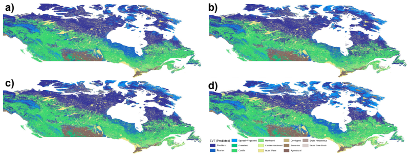
- The models' Canadian vegetation maps are continuous across the US-Canada border, whereas the LANDFIRE reference jumps abruptly at the border — a discontinuity the paper judges artificial — so measured Canadian scores likely understate true transfer quality.
- Transfer has a geographic range: gradient-boosted tree accuracy on the 13-class task falls from 0.76 to 0.55 as test latitude bands move from 41.6° to 33.6°N, so one training region does not serve arbitrarily distant areas.
- Random forest, a pixel-wise method with no learned spatial architecture, is the best transfer model; the extension approach therefore does not depend on a deep segmentation stack.
- On 80 classes the extension keeps broad spatial patterns but loses per-class fidelity (0.48 accuracy, 0.15–0.23 Jaccard/F1), establishing a granularity–accuracy tradeoff for the approach.
Reading between the lines
- Since LANDFIRE's labels were produced by decision-tree models, part of the random forest's edge may be reproducing label-generation artifacts rather than ecology; an independent field-survey test set in Canada would separate the two effects.
- The ~1.28 km receptive field means the effective resolution of transferred maps is coarser than the 10 m embedding grid, so fine-scale features such as narrow riparian corridors are where misclassifications concentrate.
- The paper selected training regions by latitude as a proxy for ecological similarity; an ecoregion-matched sampling rule should flatten the documented distance-decay curve and is a direct testable extension.
- The 2017–2024 multi-year embedding archive is not exploited; using multi-year vectors as inputs would likely suppress interannual noise and sharpen rare-class precision.
Editorial analysis
A structured set of objections, weighed in public.
Referee Report
Summary. The paper proposes a practical pipeline for extending labeled geospatial datasets to previously unlabeled regions by training simple machine-learning models (logistic regression, random forest, gradient-boosted trees, and a U-Net segmentation model) on AlphaEarth Foundations (AEF) embeddings. The case study extends LANDFIRE's Existing Vegetation Type (EVT) from the northern US and Alaska to Canada, evaluating both a coarse 13-class physiognomy (EVTPHYS) and a fine 80-class collapsed vegetation type (EVTGP). The reported results include a best validation accuracy of 0.81 for EVTPHYS and a combined Canada test accuracy of 0.73 for several models, with lower accuracy in Canada South than Canada West and a clear degradation with distance from the training region. The authors openly discuss limitations: EVT labels are noisy decision-tree outputs, there is an artificial vegetation discontinuity at the CONUS/Canada border, and metrics do not capture class similarity.
Significance. If the central claim holds, the paper offers a lightweight and scalable method for extending environmental label layers using globally available embeddings, with practical value for wildfire-risk interpretation and other downstream applications. Strengths include the use of a publicly available foundation model, a genuine cross-border transfer test in Canada, and a fairly transparent discussion of label noise and metric limitations. The significance is conditional, however, on resolving two concerns: the headline Canada accuracy is measured against a reference the paper itself identifies as biased, and the US component may partly reflect information already encoded in AEF through its land-cover reconstruction targets. The paper also provides no uncertainty quantification. These issues are addressable and do not, in my view, invalidate the approach, but they must be fixed before the claims can be accepted as stated.
major comments (5)
- [§4, Figure 3c; Tables 1 and 3] The central quantitative claim (0.73 accuracy on the combined Canada test in Table 1, and the Canada South/West split in Table 3) is measured against LANDFIRE labels that the paper itself identifies as containing an artificial discontinuity at the CONUS/Canada border and as noisy outputs of imperfect decision-tree models. The reported accuracy therefore conflates genuine transfer with disagreement against an unreliable reference. Please quantify sensitivity: e.g., recompute accuracy excluding a buffer zone around the border, or compare against an independent vegetation reference for a subset of the test region. Without such an analysis, the headline number is not a clean measure of the claimed capability.
- [§1.2; §2.1] AEF was trained with NLCD land cover among its reconstruction targets, and EVT is a vegetation/land-cover classification. The US validation and the overall framing that 'AEF embeddings can serve as an input base for extending labeled datasets' may therefore partly reflect readout of information already present in the embedding rather than a general mechanism for spatial extension. The Canadian test is a genuine transfer, but the claim should be qualified. Please add an analysis that separates 'information retrieval from AEF pretraining' from 'spatial generalization', for example by comparing against raw satellite bands as features or against a variant of AEF trained without land-cover targets.
- [§2.1 Data splits; Tables 1-4] No error bars, multiple seeds, or spatial block cross-validation are reported. Given the spatial autocorrelation in both AEF embeddings and EVT labels, and the acknowledgment in footnote 3 that AEF's 1.28 km neighborhood causes minimal leakage along tile borders, the reported differences between models (e.g., random forest 0.81 vs. other models 0.79 on EVTPHYS validation) may not be statistically meaningful. Please provide confidence intervals or repeated runs with different geographic folds, and report the standard deviation of each metric.
- [§4, Table 5] The paper's own Table 5 shows strong distance-dependent degradation (EVTPHYS accuracy drops from 0.76 to 0.55 when moving from the 41.6-38.6°N band to the 35.6-33.6°N band). This is a load-bearing limitation for the broader claim of 'scalable geospatial data generation' and 'global coverage'. The conclusion should either restrict the applicability to regions ecologically similar to the training area, or provide evidence that the method can generalize beyond such a narrow ecological envelope.
- [§3, Table 2] For EVTGP (80 classes), the best test accuracy is 0.48 with a Jaccard index of 0.15. This is a weak result that substantially limits the claim of 'extending labeled datasets' at higher granularity. The discussion attributes the drop to class similarity, but the central conclusion should be tempered or supplemented with more informative evaluation, e.g., top-k accuracy, hierarchical metrics, or a confusion analysis at the class-group level.
minor comments (6)
- [Throughout] The notation for the two granularities is inconsistent: 'EVTPHYS' and 'EvtPhys' are both used, and similarly for EVTGP. Please standardize.
- [Abstract] The abstract reports 81% and 73% accuracy for EVTPHYS, but Tables 1 and 3 show these numbers are not directly comparable: 0.81 is validation accuracy, while 0.73 is a combined Canada test set with substantial regional variation (0.69 Canada South, 0.83 Canada West). Please clarify this in the abstract.
- [§2.1] AEF embeddings are described as 10m resolution, but training is performed at 500m. Please specify the resampling method used (e.g., nearest neighbor, mode, bilinear) because for categorical land-cover labels the choice can materially affect reported metrics.
- [Footnote 3] The claim that leakage from AEF's 1.28 km neighborhood is 'minimal' and 'should not be significant' needs empirical support, e.g., a holdout that excludes a buffer larger than 1.28 km around training tiles.
- [References] References [10] and [11] appear to point to the same Google Satellite Embedding V1 dataset. Please unify them or clarify the distinction.
- [§4 and Appendix C] Table 5 is referenced in the main text but appears only in Appendix C; consider moving it to the main text or renumbering so that the reader can locate it easily.
Circularity Check
No significant circularity: the Canada transfer test is an independent out-of-distribution evaluation, and no load-bearing step reduces to its own inputs.
full rationale
The paper's derivation chain is: fixed AEF embeddings are used as input features; a supervised model (logistic regression, random forest, gradient boosting, or U-Net) is trained on LANDFIRE EVT labels from northern CONUS and Alaska; then inference is run on AEF embeddings in Canada; and accuracy is measured against LANDFIRE EVT labels in Canada. None of these steps defines the output in terms of the input in a way that would make the result true by construction. The Canadian test is genuinely out-of-distribution: training is on data from Alaska and northern CONUS above 41.6°N, while the test set is the Canadian 90 km band, which is not part of the training data. The paper explicitly reserves this Canadian data for final testing. There is no fitted parameter that is then renamed as a prediction; the models are standard supervised classifiers, and the reported Canadian accuracy is a real transfer result. The only conceptual overlap is that AEF was trained with NLCD land-cover among its reconstruction targets, so the in-region US validation accuracy may partly reflect land-cover information already encoded in the embedding. However, this does not make the Canada transfer circular, because NLCD does not provide Canadian labels, and the paper's central claim is the extension to previously unlabeled regions. The paper's own caveats about LANDFIRE being noisy decision-tree output and about an artificial vegetation discontinuity at the US–Canada border are validity limitations, not circularity. No self-citation is load-bearing (the AEF paper is cited as an external foundation model, not as proof of the present results), and no uniqueness theorem or ansatz is smuggled in via citation. Thus the derivation is self-contained with respect to the stated goal, and the circularity score is 0.
Assumptions & free parameters
free parameters (4)
- Latitude threshold for training region =
41.6 degrees N
- EVTGP class frequency threshold =
0.1%
- Spatial resolution for training =
500m
- Segmentation training schedule =
max 350 epochs, early stopping 15, Adam, LR plateau
assumptions (4)
- domain assumption AEF embeddings are globally consistent and information-dense enough to enable cross-region transfer.
- domain assumption LANDFIRE EVT is a valid target and its class definitions transfer to Canada.
- domain assumption Ecological similarity between the training region (northern CONUS and Alaska) and Canada is sufficient for transfer.
- domain assumption The 80 EVTGP classes present in the training region are the only classes needed for Canada.
Cite this review
Pith. "Pith review of Scalable Geospatial Data Generation Using AlphaEarth Foundations Model." pith.science (2026). https://pith.science/paper/GTVHUYCH
@misc{pith2026250811739,
  author       = {Pith},
  title        = {Pith review of: Scalable Geospatial Data Generation Using AlphaEarth Foundations Model},
  year         = {2026},
  howpublished = {\url{https://pith.science/paper/GTVHUYCH}},
  note         = {Machine review of arXiv:2508.11739}
}
read the original abstract
High-quality labeled geospatial datasets are essential for extracting insights and understanding our planet. Unfortunately, these datasets often do not span the entire globe and are limited to certain geographic regions where data was collected. Google DeepMind's recently released AlphaEarth Foundations (AEF) provides an information-dense global geospatial representation designed to serve as a useful input across a wide gamut of tasks. In this article we propose and evaluate a methodology which leverages AEF to extend geospatial labeled datasets beyond their initial geographic regions. We show that even basic models like random forests or logistic regression can be used to accomplish this task. We investigate a case study of extending LANDFIRE's Existing Vegetation Type (EVT) dataset beyond the USA into Canada at two levels of granularity: EvtPhys (13 classes) and EvtGp (80 classes). Qualitatively, for EvtPhys, model predictions align with ground truth. Trained models achieve 81% and 73% classification accuracy on EvtPhys validation sets in the USA and Canada, despite discussed limitations.
Figures


Figures from the paper (7 more)



Forward citations
Cited by 1 Pith paper
-
Hedgementation = Hedgerow Segmentation: A Remote Sensing Benchmark
Presents a new remote sensing benchmark for hedgerow segmentation using harmonized French data to evaluate generalization of supervised and self-supervised models across space and climate.
Reference graph
Works this paper leans on
-
[1]
A foundation model for the earth system
Cristian Bodnar, Wessel P Bruinsma, Ana Lucic, Megan Stanley, Anna Allen, Johannes Brand- stetter, Patrick Garvan, Maik Riechert, Jonathan A Weyn, Haiyu Dong, et al. A foundation model for the earth system. Nature, pages 1–8, 2025
work page 2025
- [2]
-
[3]
Christopher F. Brown, Michal R. Kazmierski, Valerie J. Pasquarella, William J. Rucklidge, Masha Samsikova, Chenhui Zhang, Evan Shelhamer, Estefania Lahera, Olivia Wiles, Simon Ilyushchenko, Noel Gorelick, Lihui Lydia Zhang, Sophia Alj, Emily Schechter, Sean Askay, Oliver Guinan, Rebecca Moore, Alexis Boukouvalas, and Pushmeet Kohli. Alphaearth founda- tio...
work page 2025
-
[4]
Artificial neural networks for land-cover classification and mapping
Daniel L Civco. Artificial neural networks for land-cover classification and mapping. Interna- tional journal of geographical information science, 7(2):173–186, 1993
work page 1993
-
[5]
RS De Fries, M Hansen, JRG Townshend, and R Sohlberg. Global land cover classifications at 8 km spatial resolution: The use of training data derived from landsat imagery in decision tree classifiers. International Journal of Remote Sensing, 19(16):3141–3168, 1998
work page 1998
-
[6]
Bert: Pre-training of deep bidirectional transformers for language understanding
Jacob Devlin, Ming-Wei Chang, Kenton Lee, and Kristina Toutanova. Bert: Pre-training of deep bidirectional transformers for language understanding. In Proceedings of the 2019 conference of the North American chapter of the association for computational linguistics: human language technologies, volume 1 (long and short papers), pages 4171–4186, 2019
2019
-
[7]
Geovex: Geospatial vectors with hexagonal convolutional autoencoders
Daniele Donghi and Anne Morvan. Geovex: Geospatial vectors with hexagonal convolutional autoencoders. In Proceedings of the 6th ACM SIGSPATIAL International Workshop on AI for Geographic Knowledge Discovery, pages 3–13, 2023
work page 2023
-
[8]
Decision tree classification of land cover from remotely sensed data
Mark A Friedl and Carla E Brodley. Decision tree classification of land cover from remotely sensed data. Remote sensing of environment, 61(3):399–409, 1997
work page 1997
Show all 36 references
-
[9]
Random forests for land cover classification
Pall Oskar Gislason, Jon Atli Benediktsson, and Johannes R Sveinsson. Random forests for land cover classification. Pattern recognition letters, 27(4):294–300, 2006
2006
-
[10]
Google satellite embedding v1, 2025
Google and Google DeepMind. Google satellite embedding v1, 2025. Accessed: 2025-07-22
2025
-
[11]
Satellite Embedding V1, 2025
Google Earth Engine Google DeepMind. Satellite Embedding V1, 2025
2025
-
[12]
The Elements of Statistical Learning: Data Mining, Inference, and Prediction
Trevor Hastie, Robert Tibshirani, and Jerome Friedman. The Elements of Statistical Learning: Data Mining, Inference, and Prediction. Springer, 2009
2009
-
[13]
Artificial neural network classification using a minimal training set- comparison to conventional supervised classification
Georgef Hepner, Thomas Logan, Niles Ritter, and Nevin Bryant. Artificial neural network classification using a minimal training set- comparison to conventional supervised classification. Photogrammetric Engineering and Remote Sensing, 56(4):469–473, 1990
1990
-
[14]
An assessment of support vector machines for land cover classification
Chengquan Huang, LS Davis, and JRG Townshend. An assessment of support vector machines for land cover classification. International Journal of remote sensing, 23(4):725–749, 2002
2002
-
[15]
Terramind: Large-scale generative multimodality for earth observation
Johannes Jakubik, Felix Yang, Benedikt Blumenstiel, Erik Scheurer, Rocco Sedona, Ste- fano Maurogiovanni, Jente Bosmans, Nikolaos Dionelis, Valerio Marsocci, Niklas Kopp, et al. Terramind: Large-scale generative multimodality for earth observation. arXiv preprint arXiv:2504.11...
2025 arXiv
-
[16]
Tile2vec: Unsupervised representation learning for spatially distributed data
Neal Jean, Sherrie Wang, Anshul Samar, George Azzari, David Lobell, and Stefano Ermon. Tile2vec: Unsupervised representation learning for spatially distributed data. In Proceedings of the AAAI Conference on Artificial Intelligence, volume 33, pages 3967–3974, 2019
2019
-
[17]
Lightgbm: A highly efficient gradient boosting decision tree
Guolin Ke, Qi Meng, Thomas Finley, Taifeng Wang, Wei Chen, Weidong Ma, Qiwei Ye, and Tie-Yan Liu. Lightgbm: A highly efficient gradient boosting decision tree. In Advances in Neural Information Processing Systems, pages 3146–3154, 2017. 10
2017
-
[18]
Satclip: Global, general-purpose location embeddings with satellite imagery
Konstantin Klemmer, Esther Rolf, Caleb Robinson, Lester Mackey, and Marc Rußwurm. Satclip: Global, general-purpose location embeddings with satellite imagery. In Proceedings of the AAAI Conference on Artificial Intelligence, volume 39, pages 4347–4355, 2025
2025
-
[19]
Landfire technical documentation
Inga P La Puma. Landfire technical documentation. Open-File Report 2023-1045. Washington DC: US Department of the Interior, US Geological Survey. 103 p., 2023
2023
-
[20]
2020 existing vegetation type layer, landfire 2.0.0, u.s
LANDFIRE. 2020 existing vegetation type layer, landfire 2.0.0, u.s. department of the interior, geological survey, and u.s. department of agriculture, accessed 16 july 2025 at. http://www.landfire/viewer
2020
-
[21]
On the opportunities and challenges of foundation models for geospatial artificial intelligence
Gengchen Mai, Weiming Huang, Jin Sun, Suhang Song, Deepak Mishra, Ninghao Liu, Song Gao, Tianming Liu, Gao Cong, Yingjie Hu, et al. On the opportunities and challenges of foundation models for geospatial artificial intelligence. arXiv preprint arXiv:2304.06798, 2023
2023 arXiv
-
[22]
Multi- scale representation learning for spatial feature distributions using grid cells
Gengchen Mai, Krzysztof Janowicz, Bo Yan, Rui Zhu, Ling Cai, and Ni Lao. Multi- scale representation learning for spatial feature distributions using grid cells. arXiv preprint arXiv:2003.00824, 2020
2003 arXiv
-
[23]
Efficient estimation of word representations in vector space
Tomas Mikolov. Efficient estimation of word representations in vector space. arXiv preprint arXiv:1301.3781, 3781, 2013
2013 arXiv
-
[24]
Random forest classifier for remote sensing classification
Mahesh Pal. Random forest classifier for remote sensing classification. International journal of remote sensing, 26(1):217–222, 2005
2005
-
[25]
Support vector machines for classification in remote sensing
Mahesh Pal and Paul M Mather. Support vector machines for classification in remote sensing. International journal of remote sensing, 26(5):1007–1011, 2005
2005
-
[26]
Pedregosa, G
F. Pedregosa, G. Varoquaux, A. Gramfort, V . Michel, B. Thirion, O. Grisel, M. Blondel, P. Prettenhofer, R. Weiss, V . Dubourg, J. Vanderplas, A. Passos, D. Cournapeau, M. Brucher, M. Perrot, and E. Duchesnay. Scikit-learn: Machine learning in Python. Journal of Machine Learni...
2011
-
[27]
Glove: Global vectors for word representation
Jeffrey Pennington, Richard Socher, and Christopher D Manning. Glove: Global vectors for word representation. In Proceedings of the 2014 conference on empirical methods in natural language processing (EMNLP), pages 1532–1543, 2014
2014
-
[28]
Peters, Mark Neumann, Mohit Iyyer, Matt Gardner, Christopher Clark, Kenton Lee, and Luke Zettlemoyer
Matthew E. Peters, Mark Neumann, Mohit Iyyer, Matt Gardner, Christopher Clark, Kenton Lee, and Luke Zettlemoyer. Deep contextualized word representations, 2018
2018
-
[29]
Landfire: a nationally consistent vegetation, wildland fire, and fuel assessment
Matthew G Rollins. Landfire: a nationally consistent vegetation, wildland fire, and fuel assessment. International Journal of Wildland Fire, 18(3):235–249, 2009
2009
-
[30]
Self-supervised vision transformers for land-cover segmentation and classification
Linus Scheibenreif, Joëlle Hanna, Michael Mommert, and Damian Borth. Self-supervised vision transformers for land-cover segmentation and classification. In Proceedings of the IEEE/CVF Conference on Computer Vision and Pattern Recognition, pages 1422–1431, 2022
2022
-
[31]
Training deep convolutional neural networks for land–cover classification of high-resolution imagery
Grant J Scott, Matthew R England, William A Starms, Richard A Marcum, and Curt H Davis. Training deep convolutional neural networks for land–cover classification of high-resolution imagery. IEEE Geoscience and Remote Sensing Letters, 14(4):549–553, 2017
2017
-
[32]
Mingxing Tan and Quoc V . Le. Efficientnet: Rethinking model scaling for convolutional neural networks. ArXiv, abs/1905.11946, 2019
1905 arXiv
-
[33]
Hex2vec: Context-aware embedding h3 hexagons with openstreetmap tags
Szymon Wo´ zniak and Piotr Szyma´nski. Hex2vec: Context-aware embedding h3 hexagons with openstreetmap tags. In Proceedings of the 4th ACM SIGSPATIAL International Workshop on AI for Geographic Knowledge Discovery, pages 61–71, 2021
2021
-
[34]
From itdl to place2vec: Reasoning about place type similarity and relatedness by learning embeddings from augmented spatial contexts
Bo Yan, Krzysztof Janowicz, Gengchen Mai, and Song Gao. From itdl to place2vec: Reasoning about place type similarity and relatedness by learning embeddings from augmented spatial contexts. In Proceedings of the 25th ACM SIGSPATIAL international conference on advances in geogr...
2017
-
[35]
Extended vision transformer (exvit) for land use and land cover classification: A multimodal deep learning framework
Jing Yao, Bing Zhang, Chenyu Li, Danfeng Hong, and Jocelyn Chanussot. Extended vision transformer (exvit) for land use and land cover classification: A multimodal deep learning framework. IEEE Transactions on Geoscience and Remote Sensing, 61:1–15, 2023
2023
-
[36]
Urban land use and land cover classification using novel deep learning models based on high spatial resolution satellite imagery
Pengbin Zhang, Yinghai Ke, Zhenxin Zhang, Mingli Wang, Peng Li, and Shuangyue Zhang. Urban land use and land cover classification using novel deep learning models based on high spatial resolution satellite imagery. Sensors, 18(11):3717, 2018. A Full Author List and Affiliation...
2018
Reviewed August 5, 2026 · model on record in the stance chip above.
Discussion (0). Sign in to comment.