REVIEW 4 major objections 4 minor 1 cited by
Towards Interpretable Geo-localization: a Concept-Aware Global Image-GPS Alignment Framework
T0 review · 4 major / 4 minor · reviewed 2026-08-05 · deepseek-v4-flash
Pith's one-line read A concept bottleneck between images and GPS coordinates makes geo-localization explainable without sacrificing accuracy.
desk verdict A plausible concept-bottleneck extension of GeoCLIP with small, consistent accuracy gains, but the interpretability story needs grounding before it can carry the paper. read the letter →
The pith
A machine-rendered reading of the paper's core claim, the machinery that carries it, and where it could break.
The reading
What carries the argument
The load-bearing object is the Concept-Aware Alignment Module with a learnable concept basis B ∈ R^{d×k}, each column starting from the frozen CLIP text embedding of a named geographic concept (B = E_concept + Δ). Image features are mapped into the concept subspace through a lightweight MLP and location features are projected directly onto B, so both modalities are compared in a space whose axes have semantic names. A contrastive image-to-location loss aligns matched pairs, while a Gaussian-kernel divergence loss enforces distribution-level consistency between image and location concept scores. This dual objective is what the paper claims simultaneously transfers world knowledge into the loc
What would settle it
Measure the cosine similarity between each trained column of B and its source CLIP text embedding; if a column's nearest neighbor in the concept vocabulary is no longer its own concept name, the semantic grounding claim fails. Also, retrain with a shuffled concept set: if accuracy and purported explanations do not degrade, the Geography-Driven Concept Set is not carrying the effect.
Extended reading notes
Core claim
The central discovery is that a CLIP-based image-GPS contrastive model can be trained with a concept bottleneck as an intermediate layer without sacrificing retrieval accuracy; in fact the concept-aware alignment improves it. The method constructs a Geography-Driven Concept Set from geographic knowledge sources, enriches it with an LLM, and manually filters it, then encodes concepts with a frozen CLIP text encoder to form a basis matrix B = E_concept + Δ. Image features are projected into the resulting concept subspace with an MLP, location features by x_loc^T B, and training minimizes an image-to-location contrastive loss plus a distribution-level divergence loss that pulls the two modaliti
Load-bearing premise
Interpretability rests on the assumption that after training, each axis of the concept subspace still means the geographic concept named by its text embedding — the learnable offset Δ in Eq. 1 is never constrained or measured, and the curated concept set is not released.
Editorial extensions
If this is right
- If the claim holds, geo-localization models can output a ranked list of geographic concepts explaining each prediction, not just a point estimate.
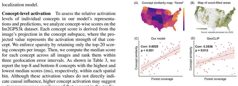
- Location embeddings become queryable for concept similarity (e.g., "forest"), producing maps that correlate with real-world distributions.
- Concept-aware pretraining transfers to tasks beyond retrieval: income, education, temperature, species classification, and country classification improve over GeoCLIP embeddings.
- The improvement is largest at fine scales (1 km, 25 km), suggesting concept cues matter most when visual scenes look similar across regions.
- The concept subspace itself becomes the interface for explanations, enabling individual and global interpretability from the same representation.
Reading between the lines
- The paper does not constrain the learnable offset Δ in Eq. 1, so one testable extension is to measure how far the trained concept basis drifts from its source text embeddings; if columns change meaning, explanations could inherit the text labels while encoding something else.
- Because the Geography-Driven Concept Set is manually curated and not released, the framework's reproducibility depends on the concept bank; an automated, released concept-selection procedure would let others test whether concept composition rather than the alignment loss drives the gains.
- The concept-level explanations shown are correlational (activation medians, post-hoc CBM weights), not causal; a natural extension is to intervene on concept scores and verify that the predicted location shifts in the direction the concept names imply.
- The same concept-bottleneck alignment recipe could be applied to other spatially grounded vision-language tasks, such as satellite image retrieval or field-level biodiversity mapping, where interpretable geographic cues are also valuable.
Editorial analysis
A structured set of objections, weighed in public.
Referee Report
Summary. The paper proposes an interpretable geo-localization framework that augments GeoCLIP-style image–GPS contrastive learning with a concept bottleneck. A manually/LLM-constructed Geography-Driven Concept Set is encoded with a frozen CLIP text encoder to form initial concept directions; a learnable offset Δ is added to form the concept basis B (Eq. 1). Image features are projected via an MLP into a k-dimensional concept space (Eq. 2), location features via B (Eq. 3), and training combines an image-to-GPS contrastive loss with a kernel-based concept-space divergence loss (Eqs. 4–7). Evaluations on Im2GPS3k report accuracy improvements over GeoCLIP (e.g., +2.4 points at 1 km), gains on downstream geospatial tasks, and qualitative/quantitative interpretability analyses (concept contributions, global decision rules, concept activation rankings, and concept similarity maps). The paper claims to be the first to introduce interpretability to geo-localization. The central accuracy claim is benchmarked externally, but the interpretability claims rest on the semantic identity of the learned concept directions, which is not directly verified.
Significance. If the claims are validated, the concept-aware alignment idea is a meaningful contribution: it connects an established contrastive geo-localization objective to concept bottlenecks, reports consistent accuracy gains on an external benchmark, and quantifies concept–geography alignment (e.g., forest similarity correlation ρ = 0.6525 vs. GeoCLIP's 0.3536). The paper's strengths include clear architecture specification, ablations against a general concept set (SpLiCE), downstream-task evaluation, and explicit threshold-based metrics. However, the core interpretability claim depends on the learned concept basis remaining semantically identified with the named concepts after training; the paper does not yet provide evidence for this. The 'first work' novelty claim is also contradicted by the paper's own citation of Theiner et al. 2022. These issues are fixable within the scope of the manuscript, but they currently prevent acceptance.
major comments (4)
- [Concept-Aware Alignment Module, Eq. (1)] The central interpretability claim is not yet grounded. B = E_concept + Δ, with Δ unconstrained and never measured. The loss (Eq. 7) does not prevent Δ from rotating/rescaling the concept directions so that columns of B no longer correspond to the named concepts. Since z_img is produced by an arbitrary MLP f_img (Eq. 2) and z_loc = x_loc^T B, the dimensions interpreted in Figs. 3–5 and Table 3 may not be the concepts they are labeled as. Please report ||Δ||_F, per-concept cosine similarity between columns of B and E_concept, or a nearest-neighbor check after training; alternatively, add a regularization or projection constraint to enforce semantic stability.
- [Abstract and Introduction] The statement 'this is the first work to introduce interpretability into geo-localization' is contradicted by the paper's own reference to Theiner et al. 2022, 'Interpretable Semantic Photo Geolocation,' which is an interpretability-oriented geo-localization method using semantic partitioning. The claim should be qualified, e.g., 'first concept-bottleneck interpretability for image–GPS alignment' or similar, to avoid a clear novelty overclaim.
- [Table 4 and Table 5] Table 4 reports SpLiCE accuracy at 200 km as 33.16, which is barely above its 25 km value (32.92) and far below the Geography-Driven value at 200 km (49.8); the 750 km value (66.73) is also anomalously low relative to the pattern. This suggests a likely typo or evaluation inconsistency that undermines the concept-set ablation. Table 5's 'W/o Concept-Aware Alignment Module' row exactly matches the GeoCLIP row in Table 1 at all thresholds, yet no error bars, number of runs, or significance tests are provided anywhere. Please re-check the SpLiCE numbers and report variances across multiple seeds.
- [Concept-Aware Embedding Analysis, Fig. 5] The quantitative forest-correlation analysis uses the same concept text embeddings (E_concept) that the model was trained to align with, and the correlation is computed on state-level averages. Because B = E_concept + Δ is trained, the reported correlation may partly reflect training to the concept set rather than an emergent geographic semantic. Please validate with held-out concepts (concepts not used in training) or a model trained with a different concept set, and report the correlation using the trained B columns as well as E_concept. Additionally, the Geography-Driven Concept Set is not released, so independent verification of concept coverage is impossible; please include the full set and the LLM prompt as supplementary material.
minor comments (4)
- [Method, Section 3] Typo: 'We integrates a Geography-Driven Concept Set' should be 'We integrate'. Also, 'Effectness' in both ablation subsection headings should be 'Effectiveness'.
- [Experiments, Dataset and Implementation Details] Capitalize consistently: 'Ten Crop' should be 'ten-crop' and 'IM2GPS3k' appears with inconsistent capitalization (Im2GPS3k elsewhere). Minor grammar: 'we also uses a Ten Crop strategy' → 'we also use a ten-crop strategy'.
- [Table 3 caption] The caption says 'median scores (ms)', which can be confused with milliseconds; consider 'med. score' and 'lowest-8' → 'bottom-8' for readability.
- [Supplementary material] The LLM prompt used for concept enrichment and the full Geography-Driven Concept Set are mentioned as included in the supplementary material; they are not present in the reviewed version. Please include them, as they are essential for reproducibility of the concept construction pipeline.
Circularity Check
No significant circularity: the accuracy claims are evaluated on an external benchmark (Im2GPS3k) and the main interpretability evidence includes an external ground-truth comparison.
full rationale
The paper's central geo-localization accuracy claim is benchmarked externally on Im2GPS3k against GeoCLIP and other published methods; no fitted parameter from the test set is renamed as a prediction. The interpretability claims are supported partly by the model's own concept-space activations, but the key quantitative interpretability result (Figure 5) correlates model location embeddings with external U.S. forest coverage data (ρ = 0.6525, p < 0.001), so it is not circular by construction. The concept-importance rankings (Table 3, Figure 4) are descriptive summaries of the model's own behavior, not predictions forced by the loss. Two non-circular weaknesses exist, but they are not circularity: (1) the abstract's 'first work to introduce interpretability into geo-localization' is contradicted by the paper's own citation of Theiner et al. 2022, 'Interpretable Semantic Photo Geolocation'; (2) Eq. 1 defines B = E_concept + Δ with no reported bound or measurement of Δ, so the semantic stability of the trained concept directions is assumed rather than demonstrated. These are correctness/validity concerns, not cases where the derivation reduces to its inputs. The external benchmark and external ground-truth correlation keep the central claims self-contained, so a circularity score of 0 is appropriate.
Assumptions & free parameters
free parameters (5)
- lambda =
10
- tau =
learnable
- Delta =
learned offset matrix
- k =
not specified
- sigma =
not specified
assumptions (4)
- domain assumption CLIP text encodings of geographic concepts carry the semantics needed for interpretable geo-alignment
- domain assumption GeoCLIP location encoder provides an adequate base embedding space
- ad hoc to paper The manually and LLM constructed concept set covers the discriminative cues for worldwide geo-localization
- ad hoc to paper The concept subspace remains interpretable after learning Delta
invented entities (1)
-
Geography-Driven Concept Set
Cite this review
Pith. "Pith review of Towards Interpretable Geo-localization: a Concept-Aware Global Image-GPS Alignment Framework." pith.science (2026). https://pith.science/paper/GGDOLSIL
@misc{pith2026250901910,
  author       = {Pith},
  title        = {Pith review of: Towards Interpretable Geo-localization: a Concept-Aware Global Image-GPS Alignment Framework},
  year         = {2026},
  howpublished = {\url{https://pith.science/paper/GGDOLSIL}},
  note         = {Machine review of arXiv:2509.01910}
}
read the original abstract
Worldwide geo-localization involves determining the exact geographic location of images captured globally, typically guided by geographic cues such as climate, landmarks, and architectural styles. Despite advancements in geo-localization models like GeoCLIP, which leverages images and location alignment via contrastive learning for accurate predictions, the interpretability of these models remains insufficiently explored. Current concept-based interpretability methods fail to align effectively with Geo-alignment image-location embedding objectives, resulting in suboptimal interpretability and performance. To address this gap, we propose a novel framework integrating global geo-localization with concept bottlenecks. Our method inserts a Concept-Aware Alignment Module that jointly projects image and location embeddings onto a shared bank of geographic concepts (e.g., tropical climate, mountain, cathedral) and minimizes a concept-level loss, enhancing alignment in a concept-specific subspace and enabling robust interpretability. To our knowledge, this is the first work to introduce interpretability into geo-localization. Extensive experiments demonstrate that our approach surpasses GeoCLIP in geo-localization accuracy and boosts performance across diverse geospatial prediction tasks, revealing richer semantic insights into geographic decision-making processes.
Figures


Figures from the paper (4 more)



Forward citations
Cited by 1 Pith paper
-
CarbonCLIP: Enhance Carbon Prediction from Satellite Imagery via Integrated Street-View Semantics and Temporal Context Training
A dual-branch contrastive learning framework distills street-view semantics and temporal context into satellite representations, improving monthly carbon emission prediction using only satellite imagery at inference.
Reference graph
Works this paper leans on
-
[1]
L.; Almeida, D.; Altenschmidt, J.; Altman, S.; Anadkat, S.; et al
Achiam, J.; Adler, S.; Agarwal, S.; Ahmad, L.; Akkaya, I.; Aleman, F. L.; Almeida, D.; Altenschmidt, J.; Altman, S.; Anadkat, S.; et al. 2023. Gpt-4 technical report. arXiv preprint arXiv:2303.08774
arXiv 2023
-
[2]
Beery, S.; Wu, G.; Edwards, T.; Pavetic, F.; Majewski, B.; Mukherjee, S.; Chan, S.; Morgan, J.; Rathod, V.; and Huang, J. 2022. The auto arborist dataset: a large-scale benchmark for multiview urban forest monitoring under domain shift. In Proceedings of the IEEE/CVF Conference on Computer Vision and Pattern Recognition, 21294--21307
work page 2022
-
[3]
Bhalla, U.; Oesterling, A.; Srinivas, S.; Calmon, F.; and Lakkaraju, H. 2024. Interpreting clip with sparse linear concept embeddings (splice). Advances in Neural Information Processing Systems, 37: 84298--84328
work page 2024
-
[4]
Clark, B.; Kerrigan, A.; Kulkarni, P. P.; Cepeda, V. V.; and Shah, M. 2023. Where we are and what we're looking at: Query based worldwide image geo-localization using hierarchies and scenes. In Proceedings of the IEEE/CVF Conference on Computer Vision and Pattern Recognition, 23182--23190
work page 2023
-
[5]
Dsouza, A.; Tempelmeier, N.; Yu, R.; Gottschalk, S.; and Demidova, E. 2021. Worldkg: A world-scale geographic knowledge graph. In Proceedings of the 30th ACM International Conference on Information & Knowledge Management, 4475--4484
work page 2021
-
[6]
Ghorbani, A.; Wexler, J.; Zou, J. Y.; and Kim, B. 2019. Towards automatic concept-based explanations. Advances in Neural Information Processing Systems, 32
work page 2019
-
[7]
Hays, J.; and Efros, A. A. 2008. Im2gps: estimating geographic information from a single image. In Proceedings of the IEEE/CVF Conference on Computer Vision and Pattern Recognition, 1--8. IEEE
work page 2008
-
[8]
Hooker, J.; Duveiller, G.; and Cescatti, A. 2018. A global dataset of air temperature derived from satellite remote sensing and weather stations. Scientific data, 5(1): 1--11
work page 2018
Show all 48 references
-
[9]
Jia, P.; Liu, Y.; Li, X.; Zhao, X.; Wang, Y.; Du, Y.; Han, X.; Wei, X.; Wang, S.; and Yin, D. 2024. G3: an effective and adaptive framework for worldwide geolocalization using large multi-modality models. Advances in Neural Information Processing Systems, 37: 53198--53221
2024
-
[10]
Jia, P.; Park, S.; Gao, S.; Zhao, X.; and Li, Y. 2025. GeoRanker: Distance-Aware Ranking for Worldwide Image Geolocalization. arXiv preprint arXiv:2505.13731
2025 arXiv
-
[11]
Klemmer, K.; Rolf, E.; Robinson, C.; Mackey, L.; and Ru wurm, M. 2025. Satclip: Global, general-purpose location embeddings with satellite imagery. In Proceedings of the AAAI Conference on Artificial Intelligence, volume 39, 4347--4355
2025
-
[12]
W.; Nguyen, T.; Tang, Y
Koh, P. W.; Nguyen, T.; Tang, Y. S.; Mussmann, S.; Pierson, E.; Kim, B.; and Liang, P. 2020. Concept bottleneck models. In International conference on machine learning, 5338--5348. PMLR
2020
-
[13]
Larson, M.; Soleymani, M.; Gravier, G.; Ionescu, B.; and Jones, G. J. 2017. The benchmarking initiative for multimedia evaluation: MediaEval 2016. IEEE MultiMedia, 24(1): 93--96
2017
-
[14]
W.; Zhang, Y.; Kwon, Y.; Yeung, S.; and Zou, J
Liang, V. W.; Zhang, Y.; Kwon, Y.; Yeung, S.; and Zou, J. Y. 2022. Mind the gap: Understanding the modality gap in multi-modal contrastive representation learning. Advances in Neural Information Processing Systems, 35: 17612--17625
2022
-
[15]
Liu, L.; and Li, H. 2019. Lending orientation to neural networks for cross-view geo-localization. In Proceedings of the IEEE/CVF Conference on Computer Vision and Pattern Recognition, 5624--5633
2019
-
[16]
Muller-Budack, E.; Pustu-Iren, K.; and Ewerth, R. 2018. Geolocation estimation of photos using a hierarchical model and scene classification. In Proceedings of the European conference on computer vision (ECCV), 563--579
2018
-
[17]
M.; and Weng, T.-W
Oikarinen, T.; Das, S.; Nguyen, L. M.; and Weng, T.-W. 2023. Label-free Concept Bottleneck Models. In The Eleventh International Conference on Learning Representations
2023
-
[18]
Parekh, J.; Khayatan, P.; Shukor, M.; Newson, A.; and Cord, M. 2024. A concept-based explainability framework for large multimodal models. Advances in Neural Information Processing Systems, 37: 135783--135818
2024
-
[19]
M.; Gleason, J.; Castillo, C
Pramanick, S.; Nowara, E. M.; Gleason, J.; Castillo, C. D.; and Chellappa, R. 2022. Where in the world is this image? transformer-based geo-localization in the wild. In European Conference on Computer Vision, 196--215. Springer
2022
-
[20]
W.; Hallacy, C.; Ramesh, A.; Goh, G.; Agarwal, S.; Sastry, G.; Askell, A.; Mishkin, P.; Clark, J.; et al
Radford, A.; Kim, J. W.; Hallacy, C.; Ramesh, A.; Goh, G.; Agarwal, S.; Sastry, G.; Askell, A.; Mishkin, P.; Clark, J.; et al. 2021. Learning transferable visual models from natural language supervision. In International conference on machine learning, 8748--8763. PmLR
2021
-
[21]
Roberts, J.; L \"u ddecke, T.; Das, S.; Han, K.; and Albanie, S. 2023. GPT4GEO: How a language model sees the world's geography. arXiv preprint arXiv:2306.00020
2023 arXiv
-
[22]
Ruiz Luyten, M.; and van der Schaar, M. 2024. A theoretical design of concept sets: improving the predictability of concept bottleneck models. Advances in Neural Information Processing Systems, 37: 100160--100195
2024
-
[23]
Ru wurm, M.; Wang, S.; Korner, M.; and Lobell, D. 2020. Meta-learning for few-shot land cover classification. In Proceedings of the IEEE/CVF Conference on Computer Vision and Pattern Recognition workshops, 200--201
2020
-
[24]
Sathianarayanan, M.; Hsu, P.-H.; and Chang, C.-C. 2024. Extracting disaster location identification from social media images using deep learning. International Journal of Disaster Risk Reduction, 104: 104352
2024
-
[25]
H.; Weyand, T.; Sim, J.; and Han, B
Seo, P. H.; Weyand, T.; Sim, J.; and Han, B. 2018. Cplanet: Enhancing image geolocalization by combinatorial partitioning of maps. In Proceedings of the European Conference on Computer Vision (ECCV), 536--551
2018
-
[26]
Shi, Y.; Yu, X.; Campbell, D.; and Li, H. 2020. Where am i looking at? joint location and orientation estimation by cross-view matching. In Proceedings of the IEEE/CVF Conference on Computer Vision and Pattern Recognition, 4064--4072
2020
-
[27]
Theiner, J.; M \"u ller-Budack, E.; and Ewerth, R. 2022. Interpretable semantic photo geolocation. In Proceedings of the IEEE/CVF Winter Conference on Applications of Computer Vision, 750--760
2022
-
[28]
A.; Friedland, G.; Elizalde, B.; Ni, K.; Poland, D.; Borth, D.; and Li, L.-J
Thomee, B.; Shamma, D. A.; Friedland, G.; Elizalde, B.; Ni, K.; Poland, D.; Borth, D.; and Li, L.-J. 2016. Yfcc100m: The new data in multimedia research. Communications of the ACM, 59(2): 64--73
2016
-
[29]
Tian, Y.; Chen, C.; and Shah, M. 2017. Cross-view image matching for geo-localization in urban environments. In Proceedings of the IEEE/CVF Conference on Computer Vision and Pattern Recognition, 3608--3616
2017
-
[30]
Van Horn, G.; Mac Aodha, O.; Song, Y.; Cui, Y.; Sun, C.; Shepard, A.; Adam, H.; Perona, P.; and Belongie, S. 2018. The inaturalist species classification and detection dataset. In Proceedings of the IEEE/CVF Conference on Computer Vision and Pattern Recognition, 8769--8778
2018
-
[31]
K.; and Shah, M
Vivanco Cepeda, V.; Nayak, G. K.; and Shah, M. 2023. Geoclip: Clip-inspired alignment between locations and images for effective worldwide geo-localization. Advances in Neural Information Processing Systems, 36: 8690--8701
2023
-
[32]
Vo, N.; Jacobs, N.; and Hays, J. 2017. Revisiting im2gps in the deep learning era. In Proceedings of the IEEE international conference on computer vision, 2621--2630
2017
-
[33]
Wang, C.; Pan, X.; Pan, Z.; Wang, H.; and Song, Y. 2025. GRE Suite: Geo-localization Inference via Fine-Tuned Vision-Language Models and Enhanced Reasoning Chains. arXiv preprint arXiv:2505.18700
2025
-
[34]
Weyand, T.; Kostrikov, I.; and Philbin, J. 2016. Planet-photo geolocation with convolutional neural networks. In European conference on computer vision, 37--55. Springer
2016
-
[35]
Workman, S.; Souvenir, R.; and Jacobs, N. 2015. Wide-area image geolocalization with aerial reference imagery. In Proceedings of the IEEE International Conference on Computer Vision, 3961--3969
2015
-
[36]
Xu, S.; Zhang, C.; Fan, L.; Meng, G.; Xiang, S.; and Ye, J. 2024. Addressclip: Empowering vision-language models for city-wide image address localization. In European Conference on Computer Vision, 76--92. Springer
2024
-
[37]
Yamaguchi, S.; and Nishida, K. 2025. Explanation Bottleneck Models. In Proceedings of the AAAI Conference on Artificial Intelligence, volume 39, 21886--21894
2025
-
[38]
Yang, H.; Lu, X.; and Zhu, Y. 2021. Cross-view geo-localization with layer-to-layer transformer. Advances in Neural Information Processing Systems, 34: 29009--29020
2021
-
[39]
Yang, Y.; Panagopoulou, A.; Zhou, S.; Jin, D.; Callison-Burch, C.; and Yatskar, M. 2023. Language in a bottle: Language model guided concept bottlenecks for interpretable image classification. In Proceedings of the IEEE/CVF Conference on Computer Vision and Pattern Recognition...
2023
-
[40]
Ye, J.; Lin, H.; Ou, L.; Chen, D.; Wang, Z.; Zhu, Q.; He, C.; and Li, W. 2024. Where am I? Cross-View Geo-localization with Natural Language Descriptions. arXiv preprint arXiv:2412.17007
2024 arXiv
-
[41]
Yeh, C.-K.; Kim, B.; Arik, S.; Li, C.-L.; Pfister, T.; and Ravikumar, P. 2020. On completeness-aware concept-based explanations in deep neural networks. Advances in Neural Information Processing Systems, 33: 20554--20565
2020
-
[42]
Yin, W.; Xiao, Z.; Zhou, P.; Yu, S.; Shen, J.; Sonke, J.-J.; and Gavves, E. 2025. Distributional Vision-Language Alignment by Cauchy-Schwarz Divergence. arXiv:2502.17028
2025
-
[43]
Yuksekgonul, M.; Wang, M.; and Zou, J. 2022. Post-hoc Concept Bottleneck Models. In The Eleventh International Conference on Learning Representations
2022
-
[44]
H.; Zhou, L.; Dai, X.; Yuan, L.; Li, Y.; et al
Zhong, Y.; Yang, J.; Zhang, P.; Li, C.; Codella, N.; Li, L. H.; Zhou, L.; Dai, X.; Yuan, L.; Li, Y.; et al. 2022. Regionclip: Region-based language-image pretraining. In Proceedings of the IEEE/CVF Conference on Computer Vision and Pattern Recognition, 16793--16803
2022
-
[45]
Zhou, Z.; Zhang, J.; Guan, Z.; Hu, M.; Lao, N.; Mu, L.; Li, S.; and Mai, G. 2024. Img2Loc: Revisiting image geolocalization using multi-modality foundation models and image-based retrieval-augmented generation. In Proceedings of the 47th international acm sigir conference on r...
2024
-
[46]
Zhu, S.; Yang, L.; Chen, C.; Shah, M.; Shen, X.; and Wang, H. 2023. R2former: Unified retrieval and reranking transformer for place recognition. In Proceedings of the IEEE/CVF Conference on Computer Vision and Pattern Recognition, 19370--19380
2023
-
[47]
, " * write output.state after.block = add.period write newline
ENTRY address archivePrefix author booktitle chapter edition editor eid eprint howpublished institution isbn journal key month note number organization pages publisher school series title type volume year label extra.label sort.label short.list INTEGERS output.state before.all...
-
[48]
write newline
" write newline "" before.all 'output.state := FUNCTION n.dashify 't := "" t empty not t #1 #1 substring "-" = t #1 #2 substring "--" = not "--" * t #2 global.max substring 't := t #1 #1 substring "-" = "-" * t #2 global.max substring 't := while if t #1 #1 substring * t #2 gl...
Reviewed August 5, 2026 · model on record in the stance chip above.
Discussion (0). Sign in to comment.