Delineate Anything Flow: Fast, Country-Level Field Boundary Detection from Any Source
Pith reviewed 2026-05-17 21:34 UTC · model grok-4.3
The pith
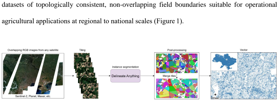
DelAnyFlow combines a fast YOLO-based segmenter with post-processing to map millions of field boundaries across entire countries from any satellite source.
A machine-rendered reading of the paper's core claim, the machinery that carries it, and where it could break.
Core claim
DelAnyFlow pairs the DelAny instance segmentation model, built on a YOLOv11 backbone and trained on the FBIS 22M dataset of 672,909 multi-resolution patches containing 22.9 million validated field instances, with a structured post-processing, merging, vectorization, and simplification stage that converts detections into clean vector boundaries. The resulting system runs at national scale: using 2024 Sentinel-2 imagery it produced a complete field boundary layer for Ukraine in under six hours on one workstation, delineating 3.75 million fields at 5 m resolution and 5.15 million at 2.5 m resolution while achieving higher boundary completeness than existing Sinergise and NASA Harvest products,
What carries the argument
DelAnyFlow: a resolution-agnostic pipeline that feeds raster detections from the DelAny model into merging, vectorization, and simplification steps to output vector field boundaries.
If this is right
- A complete national field boundary layer can be generated for a 600,000 km² country in under six hours on a single workstation.
- The method detects substantially more fields than prior operational products, especially in smallholder and fragmented landscapes between 0.25 and 1 hectare.
- Strong zero-shot performance on unseen sensors and regions allows deployment without retraining for each new area.
- The output vectors improve completeness over current public products and can serve as a starting point for land-management systems in places without digital cadastres.
Where Pith is reading between the lines
- If the pipeline generalizes reliably, national mapping programs in data-scarce regions could update field inventories annually rather than every several years.
- The same workflow might extend to other linear features such as roads or irrigation channels by swapping the training labels while keeping the post-processing unchanged.
- Combining the vector outputs with time-series imagery could support automated change detection for field consolidation or fragmentation over multiple seasons.
Load-bearing premise
The post-processing pipeline of merging, vectorization, and simplification remains robust without introducing systematic errors on new regions, sensors, or field sizes outside the FBIS 22M training distribution.
What would settle it
Apply DelAnyFlow to a new country with independent cadastral ground truth and measure whether the count and spatial accuracy of detected boundaries match the reference data within a few percent error.
Figures


read the original abstract
Accurate delineation of agricultural field boundaries from satellite imagery is essential for land management and crop monitoring, yet existing methods often produce incomplete boundaries, merge adjacent fields, and struggle to scale. We present the Delineate Anything Flow (DelAnyFlow) methodology, a resolution-agnostic approach for large-scale field boundary mapping. DelAnyFlow combines the DelAny instance segmentation model, based on a YOLOv11 backbone and trained on the large-scale Field Boundary Instance Segmentation-22M (FBIS 22M) dataset, with a structured post-processing, merging, vectorization, and simplification to generate vector boundaries. FBIS 22M, the largest dataset of its kind, contains 672,909 multi-resolution image patches (0.25-10m) and 22.9million validated field instances. The DelAny model delivers state-of-the-art accuracy with over 100% higher mAP and 400x faster inference than SAM2. DelAny demonstrates strong zero-shot generalization and supports national-scale applications: using Sentinel 2 data for 2024, DelAnyFlow generated a complete field boundary layer for Ukraine (603,000km2) in under six hours on a single workstation. DelAnyFlow outputs significantly improve boundary completeness relative to operational products from Sinergise Solutions and NASA Harvest, particularly in smallholder and fragmented systems (0.25-1ha). For Ukraine, DelAnyFlow delineated 3.75M fields at 5m and 5.15M at 2.5m, compared to 2.66M detected by Sinergise Solutions and 1.69M by NASA Harvest. This work delivers a scalable, cost-effective methodology for field delineation in regions lacking digital cadastral data. A project landing page with links to model weights, code, national-scale vector outputs, and dataset is available at https://lavreniuk.github.io/Delineate-Anything/.
Editorial analysis
A structured set of objections, weighed in public.
Referee Report
Summary. The paper introduces Delineate Anything Flow (DelAnyFlow), a resolution-agnostic pipeline for large-scale agricultural field boundary delineation from satellite imagery. It combines a YOLOv11-based instance segmentation model (DelAny) trained on the FBIS 22M dataset (672,909 multi-resolution patches and 22.9 million validated field instances) with structured post-processing, merging, vectorization, and simplification steps. The work claims state-of-the-art performance with over 100% higher mAP and 400x faster inference than SAM2, strong zero-shot generalization, and demonstrates national-scale application by mapping Ukraine (603,000 km²) in under six hours on a single workstation, producing 3.75M fields at 5 m and 5.15M at 2.5 m resolution—substantially more than Sinergise Solutions (2.66M) or NASA Harvest (1.69M) products, especially in smallholder systems.
Significance. If the empirical results hold, the work provides a practical, low-cost methodology for generating vector field boundaries at country scale in regions lacking cadastral data, with direct relevance to land management, crop monitoring, and precision agriculture. Strengths include the scale of the FBIS 22M training resource, the emphasis on resolution-agnostic operation, and the real-world deployment demonstrating feasible single-workstation processing of 603,000 km² Sentinel-2 imagery.
major comments (1)
- [Ukraine deployment results] Ukraine application (abstract and deployment results): The headline superiority in boundary completeness (3.75M fields at 5 m vs. 2.66M Sinergise / 1.69M NASA Harvest) rests on the post-processing pipeline (merging, vectorization, simplification) preserving true boundaries without systematic over-fragmentation or under-merging when applied to Ukrainian smallholder landscapes. FBIS 22M training patches may not capture the exact field-size histogram or 2.5–5 m resolution artifacts of the 2024 Ukraine run; no ablation study, sensitivity analysis on area thresholds or simplification tolerances, or quantitative validation on held-out Ukraine-like data is described to rule out pipeline-induced inflation of field counts.
minor comments (2)
- [Abstract] Abstract: '22.9million' should be written as '22.9 million' for standard formatting.
- The manuscript should explicitly define the precise metric used for 'boundary completeness' in the Ukraine comparisons (e.g., total field count after vectorization, or an overlap-based measure) to allow direct replication.
Simulated Author's Rebuttal
We thank the referee for the constructive feedback on our manuscript. We address the major comment regarding the Ukraine deployment results below, providing clarifications on the post-processing pipeline and our plans for additional analysis in revision.
read point-by-point responses
-
Referee: [Ukraine deployment results] Ukraine application (abstract and deployment results): The headline superiority in boundary completeness (3.75M fields at 5 m vs. 2.66M Sinergise / 1.69M NASA Harvest) rests on the post-processing pipeline (merging, vectorization, simplification) preserving true boundaries without systematic over-fragmentation or under-merging when applied to Ukrainian smallholder landscapes. FBIS 22M training patches may not capture the exact field-size histogram or 2.5–5 m resolution artifacts of the 2024 Ukraine run; no ablation study, sensitivity analysis on area thresholds or simplification tolerances, or quantitative validation on held-out Ukraine-like data is described to rule out pipeline-induced inflation of field counts.
Authors: We appreciate the referee raising this valid concern about potential artifacts from the post-processing steps. The FBIS 22M dataset includes multi-resolution patches (0.25–10 m) drawn from diverse agricultural regions with varying field sizes and fragmentation patterns, which informed the design of the merging, vectorization, and simplification parameters to balance completeness and accuracy. Qualitative comparisons in the manuscript (Section on Ukraine deployment) show improved detection of smallholder fields (0.25–1 ha) without obvious over-fragmentation relative to reference products. That said, we acknowledge that a dedicated ablation study on post-processing parameters and quantitative validation on held-out data mimicking Ukrainian smallholder conditions would further substantiate the claims. In the revised manuscript, we will add a sensitivity analysis on area thresholds and simplification tolerances, along with performance metrics on a held-out subset of FBIS 22M selected for similar field-size distributions and resolution characteristics. revision: yes
Circularity Check
No significant circularity; empirical deployment on new imagery
full rationale
The paper's core contribution is an empirical pipeline: training DelAny (YOLOv11-based) on the FBIS 22M dataset, applying it to 2024 Sentinel-2 imagery of Ukraine, and running post-processing to produce vector boundaries whose counts (3.75M fields at 5 m) are then compared directly to external products. No equations, fitted parameters, or self-citations are shown to reduce any reported output or completeness metric to the training inputs by construction; the Ukraine run uses data outside the training distribution and the field counts are measured outcomes rather than re-expressions of fitted quantities. The derivation chain therefore remains self-contained against external benchmarks.
Axiom & Free-Parameter Ledger
axioms (1)
- domain assumption Instance segmentation models trained on large labeled image datasets can generalize to unseen satellite imagery at different resolutions.
Lean theorems connected to this paper
-
IndisputableMonolith/Foundation/RealityFromDistinction.leanreality_from_one_distinction unclear?
unclearRelation between the paper passage and the cited Recognition theorem.
DelAnyFlow combines the DelAny instance segmentation model, based on a YOLOv11 backbone... with a structured post-processing, merging, vectorization, and simplification
-
IndisputableMonolith/Cost/FunctionalEquation.leanwashburn_uniqueness_aczel unclear?
unclearRelation between the paper passage and the cited Recognition theorem.
The DelAny model delivers state-of-the-art accuracy with over 100% higher mAP and 400x faster inference than SAM2
What do these tags mean?
- matches
- The paper's claim is directly supported by a theorem in the formal canon.
- supports
- The theorem supports part of the paper's argument, but the paper may add assumptions or extra steps.
- extends
- The paper goes beyond the formal theorem; the theorem is a base layer rather than the whole result.
- uses
- The paper appears to rely on the theorem as machinery.
- contradicts
- The paper's claim conflicts with a theorem or certificate in the canon.
- unclear
- Pith found a possible connection, but the passage is too broad, indirect, or ambiguous to say the theorem truly supports the claim.
Reference graph
Works this paper leans on
-
[1]
Vision transformer adapter for dense predictions,
doi:10.48550/ARXIV.2205.08534. Crommelinck, S., Bennett, R., Gerke, M., Nex, F., Yang, M.Y., Vosselman, G., 2016. Review of automatic feature extraction from high -resolution optical sensor data for uav -based cadastral mapping. Remote Sensing 2016, Vol. 8, Page 689 8, 689. doi:10.3390/RS8080689. D’Andrimont, R., Claverie, M., Kempeneers, P., Muraro, D., ...
-
[2]
De- sign and operation of FACT-the first G-APD Cherenkov telescope
Environmental and political i mplications of underestimated cropland burning in Ukraine. Environmental Research Letters , 16(6), 064019. DOI: 10.1088/1748- 9326/abfc04. Huang, Z., Jing, H., Liu, Y., Yang, X., Wang, Z., Liu, X., Gao, K., Luo, H., 2024. Segment anything model combined with multi-scale segmentation for extracting complex cultivated land parc...
-
[3]
Microsoft COCO: common objects in context,
Microsoft coco: Common objects in context. Lecture Notes in Computer Science (including subseries Lecture Notes in Artificial Intelligence and Lecture Notes in Bioinformatics) 8693 LNCS, 740–755. doi:10.1007/978-3-319-10602-1_48. Liu, S., Liu, L., Xu, F., Chen, J., Yuan, Y., Chen, X., 2022. A deep learning method for individual arable field (iaf) extracti...
-
[4]
Lu, R., Wang, N., Zhang, Y., Lin, Y., Wu, W., Shi, Z., 2022
doi:10.1109/TPAMI.2018.2878849. Lu, R., Wang, N., Zhang, Y., Lin, Y., Wu, W., Shi, Z., 2022. Extraction of agricultural fields via dasfnet with dual attention mechanism and multi -scale feature fusion in south xinjiang, china. Remote Sensing 2022, Vol. 14, Page 2253 14, 2253. doi:10.3390/RS14092253. Lv, Y., Zhang, C., Yun, W., Gao, L., Wang, H., Ma, J., L...
discussion (0)
Sign in with ORCID, Apple, or X to comment. Anyone can read and Pith papers without signing in.