REVIEW 4 major objections 6 minor 83 references
SkyLume isolates illumination from viewpoint in 100K+ urban aerial images, showing current 3D reconstruction methods are not robust to sunlight changes.
Reviewed by Pith at T0; open to challenge. T0 means a machine referee read the full paper against a public rubric. the ladder, T0–T4 →
T0 review · deepseek-v4-flash
2026-08-03 16:13 UTC pith:T2SPAVQ5
load-bearing objection SkyLume's dataset is the real contribution and worth serious refereeing; the static-scene assumption is unquantified, TCC is self-referential, and there's no release link yet. the 4 major comments →
Beyond a Single Light: A Large-Scale Aerial Dataset for Urban Scene Reconstruction Under Varying Illumination
The pith
A machine-rendered reading of the paper's core claim, the machinery that carries it, and where it could break.
Core claim
SkyLume consists of more than 100,000 six-megapixel images from five synchronized views over ten urban regions, each region flown in the morning, at noon, and in the late afternoon along identical RTK-guided waypoints. LiDAR scans provide metric ground truth, and a unified structure-from-motion registration locks all time slots into one coordinate system, so the only intended variable is illumination. Benchmarked 3D Gaussian Splatting variants show substantial quality loss under direct sun: cast shadows and moving penumbras are frequently reconstructed as solid geometry, albedo from inverse rendering retains shading and varies across time, and novel view synthesis blurs on weakly textured an
What carries the argument
The load-bearing mechanism is the capture protocol: repeating the same flight trajectory at three times of day and registering all images to a common LiDAR-guided coordinate system, which converts multi-temporal capture into a controlled illumination experiment. The TCC metric is the evaluation mechanism: it renders albedo from K fixed test viewpoints in each of the three time slots, compares each slot against the temporal mean, and combines MAE, RMSE, SSIM, and LPIPS into a single [0,1] consistency score.
Load-bearing premise
Each urban scene is effectively static across the three capture sessions, so measured differences are attributed to illumination rather than to scene change.
What would settle it
Compare TCC scores and geometry F1 in regions with known moving objects (vehicles, pedestrians, cloud-shadow boundaries) versus static regions; if dynamic regions show systematically higher instability, the attribution to illumination alone fails.
If this is right
- Current 3D Gaussian Splatting methods can now be ranked and improved on a controlled illumination-robustness benchmark, rather than on ad hoc captures.
- Researchers can isolate shadow-induced geometry bias by comparing reconstructions from sunlit versus overcast slots against the same LiDAR ground truth.
- The provided solar geometry (elevation and azimuth per image) enables future de-shadowing, relighting, and illumination-aware training.
- The standardized splits allow direct comparison of novel view synthesis methods under identical viewpoint and lighting conditions.
- City-scale inverse rendering can be evaluated for material/light disentanglement via TCC, a task previously limited to small objects or synthetic scenes.
Where Pith is reading between the lines
- The static-scene assumption is the clear risk: urban areas contain moving vehicles, pedestrians, and cloud shadows, so TCC and cross-time geometry scores could conflate illumination effects with object dynamics; masking dynamic regions would sharpen the benchmark.
- The TCC design—fixed viewpoints, temporal mean, per-viewpoint aggregation—is general enough to be applied to other repeat-photography setups, such as ground-level cameras or multi-day satellite revisits, as a measure of appearance stability.
- The observed result that diffuse illumination yields the most stable geometry suggests a practical capture policy: fly under overcast conditions when geometry is the priority, and use sunlit slots for appearance and albedo studies.
- The dataset could double as a real-world domain-shift test for generalizable reconstruction models trained on synthetic data, since it provides true illumination variation with ground truth.
Editorial analysis
A structured set of objections, weighed in public.
Referee Report
Summary. SkyLume is introduced as a large-scale, real-world UAV aerial dataset for urban scene reconstruction under varying illumination. The dataset comprises 10 urban regions, more than 100K six-megapixel images captured from five directions (four oblique and one nadir) at three times of day (morning, noon, afternoon), with per-scene LiDAR scans, unified 6-DoF poses, LiDAR-derived ground-truth depth and normals, and solar-geometry annotations. The paper also proposes Temporal Consistency Coefficient (TCC), a metric intended to evaluate cross-time albedo stability for inverse rendering, and benchmarks several 3D Gaussian Splatting variants on geometry, novel view synthesis, and albedo-consistency tracks. The central claim is that SkyLume is the first real-world aerial dataset that systematically isolates illumination changes from viewpoint changes at city scale, enabling rigorous evaluation of illumination-robust reconstruction.
Significance. If the central claims hold, SkyLume fills a genuine gap in aerial 3D vision: prior real-world UAV datasets either do not revisit the same area under systematically varying illumination or lack high-precision geometry. The dataset's acquisition is carefully described, and the reported alignment statistics (median reprojection error 0.70 px, millimeter-level relative pose uncertainty, Table 7) suggest a high-quality, unified multi-temporal SfM solution. The per-frame LiDAR depth and solar-geometry annotations add practical value for downstream tasks. The benchmark experiments reveal plausible trends, such as geometry degradation under hard shadows. However, the evaluation methodology has two load-bearing weaknesses: (1) the static-scene assumption under which illumination is isolated is asserted but not quantified or enforced; (2) the TCC metric measures consistency against the temporal mean of the very albedo maps being evaluated, so it cannot validate whether the disentangled albedo is correct, and it rewards trivially constant albedo. These issues do not necessarily invalidate the dataset itself, but they currently weaken the claimed contributions. With substantial revisions—parti
major comments (4)
- [§3.2, §6.1, Table 6, Fig. 6 caption] yes
- [§4.1, Eq. (8)-(14)] yes
- [§3.3, Fig. 3, §3.2] yes
- [General] yes
minor comments (6)
- [§4.3, Table 3] The text says 'Period 0 and Period 1' (Sec. 4.3) but Table 3 lists 'Period 1' and 'Period 2'. This inconsistency should be corrected. Also, 'between the the meshes' is a typo.
- [Eq. (10)-(11)] The constants in the saturation functions are not justified. Units of MAE and RMSE should be stated (e.g., 0-1 albedo range), and the choice of 10 should be discussed.
- [Table 1] Typo 'ISPRS-Bencnmark' should be 'ISPRS-Benchmark'. Also, the 'Light' column header could be clarified as 'Varying Illumination'.
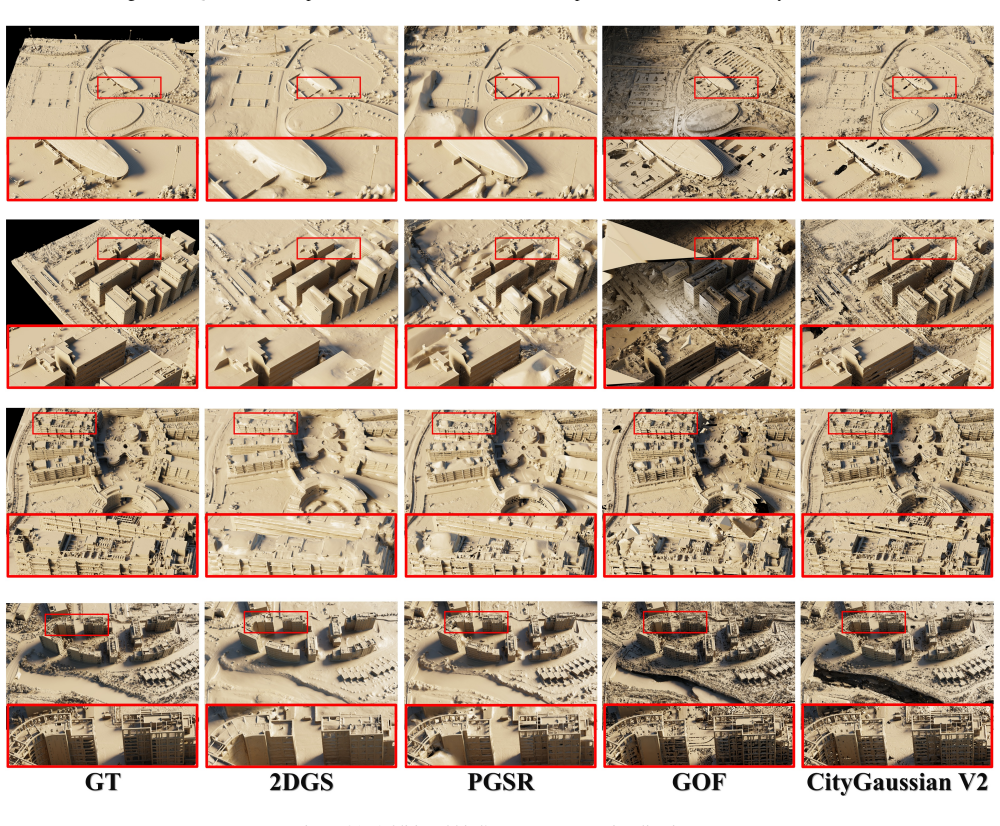
- [Fig. 6 caption] The phrase 'differences arise solely from illumination' is too strong given the static-scene issue; it should be rephrased to match the more cautious claim in the supplementary.
- [References] References [11] and [12] are duplicates of the same 3DGS paper. Please consolidate.
- [§3.3] Typo 'RealityScanto' appears in Sec. 3.3; also 'COLMAP' formatting is inconsistent.
Axiom & Free-Parameter Ledger
free parameters (4)
- TCC component weights =
α=β=θ=0.2, γ=0.4
- TCC MAE/RMSE saturation scale =
10
- Geometry distance thresholds =
0.25, 0.5, 0.75 m
- Unified single-GPU training schedule =
90k iterations, densification interval 300, opacity reset 9000, densification disabled after 60k
axioms (4)
- domain assumption Urban scenes are static across the three time-of-day captures
- domain assumption LiDAR-guided SfM registration in RealityScan yields cm-level accurate poses
- domain assumption LiDAR-guided MVS mesh is a valid ground-truth surface
- domain assumption The 80/60 overlap, 120 m altitude, and 1 Hz trigger provide sufficient multiview coverage
invented entities (1)
-
Temporal Consistency Coefficient (TCC)
no independent evidence
read the original abstract
Recent advances in Neural Radiance Fields and 3D Gaussian Splatting have demonstrated strong potential for large-scale UAV-based 3D reconstruction tasks by fitting the appearance of images. However, real-world large-scale captures are often based on multi-temporal data capture, where illumination inconsistencies across different times of day can significantly lead to color artifacts, geometric inaccuracies, and inconsistent appearance. Due to the lack of UAV datasets that systematically capture the same areas under varying illumination conditions, this challenge remains largely underexplored. To fill this gap, we introduceSkyLume, a large-scale, real-world UAV dataset specifically designed for studying illumination robust 3D reconstruction in urban scene modeling: (1) We collect data from 10 urban regions data comprising more than 100k high resolution UAV images (four oblique views and nadir), where each region is captured at three periods of the day to systematically isolate illumination changes. (2) To support precise evaluation of geometry and appearance, we provide per-scene LiDAR scans and accurate 3D ground-truth for assessing depth, surface normals, and reconstruction quality under varying illumination. (3) For the inverse rendering task, we introduce the Temporal Consistency Coefficient (TCC), a metric that measuress cross-time albedo stability and directly evaluates the robustness of the disentanglement of light and material. We aim for this resource to serve as a foundation that advances research and real-world evaluation in large-scale inverse rendering, geometry reconstruction, and novel view synthesis.
Figures


Reference graph
Works this paper leans on
-
[1]
Pgsr: Planar-based gaussian splatting for efficient and high-fidelity surface reconstruction
Danpeng Chen, Hai Li, Weicai Ye, Yifan Wang, Weijian Xie, Shangjin Zhai, Nan Wang, Haomin Liu, Hujun Bao, and Guofeng Zhang. Pgsr: Planar-based gaussian splatting for efficient and high-fidelity surface reconstruction. 2024. 3, 5, 7
2024
-
[2]
Gigags: Scaling up planar-based 3d gaussians for large scene surface reconstruction, 2024
Junyi Chen, Weicai Ye, Yifan Wang, Danpeng Chen, Di Huang, Wanli Ouyang, Guofeng Zhang, Yu Qiao, and Tong He. Gigags: Scaling up planar-based 3d gaussians for large scene surface reconstruction, 2024. 2, 3
2024
-
[3]
Dogaussian: Distributed- oriented gaussian splatting for large-scale 3d reconstruction via gaussian consensus, 2024
Yu Chen and Gim Hee Lee. Dogaussian: Distributed- oriented gaussian splatting for large-scale 3d reconstruction via gaussian consensus, 2024. 2
2024
-
[4]
Devansh Dhrafani, Yifei Liu, Andrew Jong, Ukcheol Shin, Yao He, Tyler Harp, Yaoyu Hu, Jean Oh, and Sebastian Scherer. Firestereo: Forest infrared stereo dataset for uas depth perception in visually degraded environments.arXiv preprint arXiv:2409.07715, 2024. 3
Pith/arXiv arXiv 2024
-
[5]
Mini-splatting: Represent- ing scenes with a constrained number of gaussians, 2024
Guangchi Fang and Bing Wang. Mini-splatting: Represent- ing scenes with a constrained number of gaussians, 2024. 3
2024
-
[6]
Mid-air: A multi-modal dataset for extremely low altitude drone flights
Michael Fonder and Marc Van Droogenbroeck. Mid-air: A multi-modal dataset for extremely low altitude drone flights. InProceedings of the IEEE/CVF conference on computer vi- sion and pattern recognition workshops, pages 0–0, 2019. 3
2019
-
[7]
Antoine Gu ´edon and Vincent Lepetit. Sugar: Surface- aligned gaussian splatting for efficient 3d mesh recon- struction and high-quality mesh rendering.arXiv preprint arXiv:2311.12775, 2023. 3
Pith/arXiv arXiv 2023
-
[8]
2d gaussian splatting for geometrically accu- rate radiance fields
Binbin Huang, Zehao Yu, Anpei Chen, Andreas Geiger, and Shenghua Gao. 2d gaussian splatting for geometrically accu- rate radiance fields. InSIGGRAPH 2024 Conference Papers. Association for Computing Machinery, 2024. 3, 5, 7, 8
2024
-
[9]
Horizon- gs: Unified 3d gaussian splatting for large-scale aerial-to- ground scenes
Lihan Jiang, Kerui Ren, Mulin Yu, Linning Xu, Junting Dong, Tao Lu, Feng Zhao, Dahua Lin, and Bo Dai. Horizon- gs: Unified 3d gaussian splatting for large-scale aerial-to- ground scenes. InProceedings of the Computer Vision and Pattern Recognition Conference, pages 26789–26799, 2025. 2, 3
2025
-
[10]
Gaussian- shader: 3d gaussian splatting with shading functions for re- flective surfaces
Yingwenqi Jiang, Jiadong Tu, Yuan Liu, Xifeng Gao, Xi- aoxiao Long, Wenping Wang, and Yuexin Ma. Gaussian- shader: 3d gaussian splatting with shading functions for re- flective surfaces. InProceedings of the IEEE/CVF Confer- ence on Computer Vision and Pattern Recognition, pages 5322–5332, 2024. 3
2024
-
[11]
3d gaussian splatting for real-time radiance field rendering.ACM Transactions on Graphics, 42 (4), 2023
Bernhard Kerbl, Georgios Kopanas, Thomas Leimk ¨uhler, and George Drettakis. 3d gaussian splatting for real-time radiance field rendering.ACM Transactions on Graphics, 42 (4), 2023. 5
2023
-
[12]
3d gaussian splatting for real-time radiance field rendering.ACM Trans
Bernhard Kerbl, Georgios Kopanas, Thomas Leimk ¨uhler, and George Drettakis. 3d gaussian splatting for real-time radiance field rendering.ACM Trans. Graph., 42(4):139–1,
-
[13]
3d gaussian splat- ting as markov chain monte carlo
Shakiba Kheradmand, Daniel Rebain, Gopal Sharma, Wei- wei Sun, Yang-Che Tseng, Hossam Isack, Abhishek Kar, Andrea Tagliasacchi, and Kwang Moo Yi. 3d gaussian splat- ting as markov chain monte carlo. InAdvances in Neural Information Processing Systems (NeurIPS), 2024. Spotlight Presentation. 3
2024
-
[14]
Shading-aware multi-view stereo
Fabian Langguth, Kalyan Sunkavalli, Sunil Hadap, and Michael Goesele. Shading-aware multi-view stereo. In European Conference on Computer Vision, pages 469–485. Springer, 2016. 2
2016
-
[15]
SGLoc: Scene geometry en- coding for outdoor LiDAR localization
Wen Li, Shangshu Yu, Cheng Wang, Guosheng Hu, Siqi Shen, and Chenglu Wen. SGLoc: Scene geometry en- coding for outdoor LiDAR localization. InProceedings of the IEEE/CVF Conference on Computer Vision and Pattern Recognition, pages 9286–9295, 2023. 3
2023
-
[16]
Matrixcity: A large-scale city dataset for city-scale neural rendering and beyond
Yixuan Li, Lihan Jiang, Linning Xu, Yuanbo Xiangli, Zhen- zhi Wang, Dahua Lin, and Bo Dai. Matrixcity: A large-scale city dataset for city-scale neural rendering and beyond. In Proceedings of the IEEE/CVF International Conference on Computer Vision, pages 3205–3215, 2023. 2, 3
2023
-
[17]
Garcia- Fernandez, Yong Yue, Eng Gee Lim, and Xiaohui Zhu
Zhuoxiao Li, Shanliang Yao, Yijie Chu, Angel F. Garcia- Fernandez, Yong Yue, Eng Gee Lim, and Xiaohui Zhu. Mvg-splatting: Multi-view guided gaussian splatting with adaptive quantile-based geometric consistency densification,
-
[18]
Garc´ıa-Fern´andez, Andrew Levers, Jason Ralph, and Xiaohui Zhu
Zhuoxiao Li, Shanliang Yao, Taoyu Wu, Yong Yue, Wu- fan Zhao, Rongjun Qin, ´Angel F. Garc´ıa-Fern´andez, Andrew Levers, Jason Ralph, and Xiaohui Zhu. Ulsr-gs: Urban large- scale surface reconstruction gaussian splatting with multi- view geometric consistency.ISPRS Journal of Photogram- metry and Remote Sensing, 230:861–880, 2025. 3
2025
-
[19]
Gs-ir: 3d gaussian splatting for inverse rendering
Zhihao Liang, Qi Zhang, Ying Feng, Ying Shan, and Kui Jia. Gs-ir: 3d gaussian splatting for inverse rendering. InPro- ceedings of the IEEE/CVF Conference on Computer Vision and Pattern Recognition, pages 21644–21653, 2024. 3, 5, 6
2024
-
[20]
Chen, Zhenyu Li, Guang Shi, Jiashi Feng, and Bingyi Kang
Haotong Lin, Sili Chen, Jun Hao Liew, Donny Y . Chen, Zhenyu Li, Guang Shi, Jiashi Feng, and Bingyi Kang. Depth anything 3: Recovering the visual space from any views. arXiv preprint arXiv:2511.10647, 2025. 5
Pith/arXiv arXiv 2025
-
[21]
Vastgaussian: Vast 3d gaussians for large scene reconstruction
Jiaqi Lin, Zhihao Li, Xiao Tang, Jianzhuang Liu, Shiy- ong Liu, Jiayue Liu, Yangdi Lu, Xiaofei Wu, Songcen Xu, Youliang Yan, and Wenming Yang. Vastgaussian: Vast 3d gaussians for large scene reconstruction. InProceedings of the IEEE/CVF Conference on Computer Vision and Pattern Recognition (CVPR), pages 5166–5175, 2024. 2, 3
2024
-
[22]
Capturing, reconstructing, and simulating: the urbanscene3d dataset
Liqiang Lin, Yilin Liu, Yue Hu, Xingguang Yan, Ke Xie, and Hui Huang. Capturing, reconstructing, and simulating: the urbanscene3d dataset. InEuropean Conference on Computer Vision, pages 93–109. Springer, 2022. 2, 3
2022
-
[23]
Urbanscene3d: A large scale urban scene dataset and simulator
Yilin Liu, Fuyou Xue, and Hui Huang. Urbanscene3d: A large scale urban scene dataset and simulator. 2021. 2, 3
2021
-
[24]
Yang Liu, He Guan, Chuanchen Luo, Lue Fan, Naiyan Wang, Junran Peng, and Zhaoxiang Zhang. Citygaus- sian: Real-time high-quality large-scale scene rendering with gaussians.arXiv preprint arXiv:2404.01133, 2024. 3
Pith/arXiv arXiv 2024
-
[25]
Citygaussianv2: Efficient and geometri- cally accurate reconstruction for large-scale scenes
Yang Liu, Chuanchen Luo, Zhongkai Mao, Junran Peng, and Zhaoxiang Zhang. Citygaussianv2: Efficient and geometri- cally accurate reconstruction for large-scale scenes. InICLR,
-
[26]
Scaffold-gs: Structured 3d 9 gaussians for view-adaptive rendering
Tao Lu, Mulin Yu, Linning Xu, Yuanbo Xiangli, Limin Wang, Dahua Lin, and Bo Dai. Scaffold-gs: Structured 3d 9 gaussians for view-adaptive rendering. InProceedings of the IEEE/CVF Conference on Computer Vision and Pattern Recognition, pages 20654–20664, 2024. 3
2024
-
[27]
Switch-nerf: Learning scene de- composition with mixture of experts for large-scale neural radiance fields
Zhenxing Mi and Dan Xu. Switch-nerf: Learning scene de- composition with mixture of experts for large-scale neural radiance fields. InInternational Conference on Learning Representations (ICLR), 2023. 2
2023
-
[28]
Nerf: Representing scenes as neural radiance fields for view syn- thesis.Communications of the ACM, 65(1):99–106, 2021
Ben Mildenhall, Pratul P Srinivasan, Matthew Tancik, Jonathan T Barron, Ravi Ramamoorthi, and Ren Ng. Nerf: Representing scenes as neural radiance fields for view syn- thesis.Communications of the ACM, 65(1):99–106, 2021. 2
2021
-
[29]
F. Nex, M. Gerke, F. Remondino, H.-J. Przybilla, M. B¨aumker, and A. Zurhorst. Isprs benchmark for multi- platform photogrammetry.ISPRS Annals of the Photogram- metry, Remote Sensing and Spatial Information Sciences, II- 3/W4:135–142, 2015. 2, 3
2015
-
[30]
Ntu viral: A visual- inertial-ranging-lidar dataset, from an aerial vehicle view- point.The International Journal of Robotics Research, 41 (3):270–280, 2022
Thien-Minh Nguyen, Shenghai Yuan, Muqing Cao, Yang Lyu, Thien H Nguyen, and Lihua Xie. Ntu viral: A visual- inertial-ranging-lidar dataset, from an aerial vehicle view- point.The International Journal of Robotics Research, 41 (3):270–280, 2022. 3
2022
-
[31]
Multi-view relighting using a geometry-aware network.ACM Trans
Julien Philip, Micha ¨el Gharbi, Tinghui Zhou, Alexei A Efros, and George Drettakis. Multi-view relighting using a geometry-aware network.ACM Trans. Graph., 38(4):78–1,
-
[32]
Kerui Ren, Lihan Jiang, Tao Lu, Mulin Yu, Linning Xu, Zhangkai Ni, and Bo Dai. Octree-gs: Towards consistent real-time rendering with lod-structured 3d gaussians.arXiv preprint arXiv:2403.17898, 2024. 3, 5, 8
Pith/arXiv arXiv 2024
-
[33]
Syndrone-multi-modal uav dataset for ur- ban scenarios
Giulia Rizzoli, Francesco Barbato, Matteo Caligiuri, and Pietro Zanuttigh. Syndrone-multi-modal uav dataset for ur- ban scenarios. InProceedings of the IEEE/CVF Interna- tional Conference on Computer Vision, pages 2210–2220,
-
[34]
Structure- from-motion revisited
Johannes L Schonberger and Jan-Michael Frahm. Structure- from-motion revisited. InProceedings of the IEEE con- ference on computer vision and pattern recognition, pages 4104–4113, 2016. 2
2016
-
[35]
A comparison and evalua- tion of multi-view stereo reconstruction algorithms
Steven M Seitz, Brian Curless, James Diebel, Daniel Scharstein, and Richard Szeliski. A comparison and evalua- tion of multi-view stereo reconstruction algorithms. In2006 IEEE computer society conference on computer vision and pattern recognition (CVPR’06), pages 519–528. IEEE, 2006. 2
2006
-
[36]
Flod: Integrating flexible level of detail into 3d gaussian splatting for customizable rendering, 2024
Yunji Seo, Young Sun Choi, Hyun Seung Son, and Youngjung Uh. Flod: Integrating flexible level of detail into 3d gaussian splatting for customizable rendering, 2024. 3
2024
-
[37]
A general albedo recovery approach for aerial photogrammetric images through inverse rendering.ISPRS Journal of Photogrammetry and Remote Sensing, 218:101–119, 2024
Shuang Song and Rongjun Qin. A general albedo recovery approach for aerial photogrammetric images through inverse rendering.ISPRS Journal of Photogrammetry and Remote Sensing, 218:101–119, 2024. 2
2024
-
[38]
Mega-nerf: Scalable construction of large- scale nerfs for virtual fly-throughs
Haithem Turki, Deva Ramanan, and Mahadev Satya- narayanan. Mega-nerf: Scalable construction of large- scale nerfs for virtual fly-throughs. InProceedings of the IEEE/CVF Conference on Computer Vision and Pattern Recognition (CVPR), pages 12922–12931, 2022. 2, 3
2022
-
[39]
Dn-splatter: Depth and normal priors for gaussian splatting and meshing, 2024
Matias Turkulainen, Xuqian Ren, Iaroslav Melekhov, Otto Seiskari, Esa Rahtu, and Juho Kannala. Dn-splatter: Depth and normal priors for gaussian splatting and meshing, 2024. 3
2024
-
[40]
Aerialmegadepth: Learning aerial-ground reconstruction and view synthesis
Khiem Vuong, Anurag Ghosh, Deva Ramanan, Srinivasa Narasimhan, and Shubham Tulsiani. Aerialmegadepth: Learning aerial-ground reconstruction and view synthesis. In Proceedings of the IEEE/CVF Conference on Computer Vi- sion and Pattern Recognition, 2025. 3
2025
-
[41]
Moge-2: Accurate monocular geometry with metric scale and sharp details, 2025
Ruicheng Wang, Sicheng Xu, Yue Dong, Yu Deng, Jianfeng Xiang, Zelong Lv, Guangzhong Sun, Xin Tong, and Jiaolong Yang. Moge-2: Accurate monocular geometry with metric scale and sharp details, 2025. 5
2025
-
[42]
Uavscenes: A multi-modal dataset for uavs
Sijie Wang, Siqi Li, Yawei Zhang, Shangshu Yu, Shenghai Yuan, Rui She, Quanjiang Guo, JinXuan Zheng, Ong Kang Howe, Leonrich Chandra, et al. Uavscenes: A multi-modal dataset for uavs. InProceedings of the IEEE/CVF Interna- tional Conference on Computer Vision, pages 28946–28958,
-
[43]
Tartanair: A dataset to push the limits of visual slam
Wenshan Wang, Delong Zhu, Xiangwei Wang, Yaoyu Hu, Yuheng Qiu, Chen Wang, Yafei Hu, Ashish Kapoor, and Se- bastian Scherer. Tartanair: A dataset to push the limits of visual slam. 2020. 3
2020
-
[44]
Image quality assessment: from error visibility to structural similarity.IEEE transactions on image processing, 13(4):600–612, 2004
Zhou Wang, Alan C Bovik, Hamid R Sheikh, and Eero P Si- moncelli. Image quality assessment: from error visibility to structural similarity.IEEE transactions on image processing, 13(4):600–612, 2004. 6
2004
-
[45]
Trun- cated signed distance function: experiments on voxel size
Diana Werner, Ayoub Al-Hamadi, and Philipp Werner. Trun- cated signed distance function: experiments on voxel size. InImage Analysis and Recognition: 11th International Con- ference, ICIAR 2014, Vilamoura, Portugal, October 22-24, 2014, Proceedings, Part II 11, pages 357–364. Springer,
2014
-
[46]
Surface re- construction from gaussian splatting via novel stereo views
Yaniv Wolf, Amit Bracha, and Ron Kimmel. Surface re- construction from gaussian splatting via novel stereo views. arXiv preprint arXiv:2404.01810, 2024. 3
Pith/arXiv arXiv 2024
-
[47]
Uavd4l: A large-scale dataset for uav 6-dof localization
Rouwan Wu, Xiaoya Cheng, Juelin Zhu, Yuxiang Liu, Mao- jun Zhang, and Shen Yan. Uavd4l: A large-scale dataset for uav 6-dof localization. In2024 International Conference on 3D Vision (3DV), pages 1574–1583. IEEE, 2024. 3
2024
-
[48]
En- vgs: Modeling view-dependent appearance with environ- ment gaussian
Tao Xie, Xi Chen, Zhen Xu, Yiman Xie, Yudong Jin, Yu- jun Shen, Sida Peng, Hujun Bao, and Xiaowei Zhou. En- vgs: Modeling view-dependent appearance with environ- ment gaussian. InProceedings of the Computer Vision and Pattern Recognition Conference, pages 5742–5751, 2025. 2, 3
2025
-
[49]
Butian Xiong, Nanjun Zheng, Junhua Liu, and Zhen Li. Gauu-scene v2: Assessing the reliability of image-based metrics with expansive lidar image dataset using 3dgs and nerf.arXiv preprint arXiv:2404.04880, 2024. 2, 3
Pith/arXiv arXiv 2024
-
[50]
Gauu-scene v2: Assessing the reliability of image-based metrics with expansive lidar image dataset using 3dgs and nerf.CoRR, 2024
Butian Xiong, Nanjun Zheng, Junhua Liu, and Zhen Li. Gauu-scene v2: Assessing the reliability of image-based metrics with expansive lidar image dataset using 3dgs and nerf.CoRR, 2024. 2
2024
-
[51]
Crossloc: Scalable aerial localization as- sisted by multimodal synthetic data
Qi Yan, Jianhao Zheng, Simon Reding, Shanci Li, and Ior- dan Doytchinov. Crossloc: Scalable aerial localization as- sisted by multimodal synthetic data. InProceedings of 10 the IEEE/CVF Conference on Computer Vision and Pattern Recognition, pages 17358–17368, 2022. 3
2022
-
[52]
Spec-gaussian: Anisotropic view-dependent ap- pearance for 3d gaussian splatting, 2024
Ziyi Yang, Xinyu Gao, Yangtian Sun, Yihua Huang, Xi- aoyang Lyu, Wen Zhou, Shaohui Jiao, Xiaojuan Qi, and Xi- aogang Jin. Spec-gaussian: Anisotropic view-dependent ap- pearance for 3d gaussian splatting, 2024. 3
2024
-
[53]
Reflective gaussian splatting.arXiv preprint arXiv:2412.19282, 2024
Yuxuan Yao, Zixuan Zeng, Chun Gu, Xiatian Zhu, and Li Zhang. Reflective gaussian splatting.arXiv preprint arXiv:2412.19282, 2024. 2, 3, 5, 6
Pith/arXiv arXiv 2024
-
[54]
Stablenormal: Reducing diffusion variance for stable and sharp normal.ACM Transactions on Graphics (TOG), 2024
Chongjie Ye, Lingteng Qiu, Xiaodong Gu, Qi Zuo, Yushuang Wu, Zilong Dong, Liefeng Bo, Yuliang Xiu, and Xiaoguang Han. Stablenormal: Reducing diffusion variance for stable and sharp normal.ACM Transactions on Graphics (TOG), 2024. 5
2024
-
[55]
3d gaussian splat- ting with deferred reflection
Keyang Ye, Qiming Hou, and Kun Zhou. 3d gaussian splat- ting with deferred reflection. InACM SIGGRAPH 2024 Con- ference Papers, pages 1–10, 2024. 3
2024
-
[56]
Absgs: Recovering fine details for 3d gaussian splat- ting, 2024
Zongxin Ye, Wenyu Li, Sidun Liu, Peng Qiao, and Yong Dou. Absgs: Recovering fine details for 3d gaussian splat- ting, 2024. 5, 8
2024
-
[57]
Mip-splatting: Alias-free 3d gaussian splat- ting
Zehao Yu, Anpei Chen, Binbin Huang, Torsten Sattler, and Andreas Geiger. Mip-splatting: Alias-free 3d gaussian splat- ting. InProceedings of the IEEE/CVF Conference on Com- puter Vision and Pattern Recognition, pages 19447–19456,
-
[58]
Zehao Yu, Torsten Sattler, and Andreas Geiger. Gaussian opacity fields: Efficient high-quality compact surface recon- struction in unbounded scenes.arXiv:2404.10772, 2024. 3, 5, 7
Pith/arXiv arXiv 2024
-
[59]
Dogaussian: Distributed-oriented gaussian splatting for large-scale 3d reconstruction via gaus- sian consensus
Gim Hee Lee Yu Chen. Dogaussian: Distributed-oriented gaussian splatting for large-scale 3d reconstruction via gaus- sian consensus. InarXiv, 2024. 3
2024
-
[60]
Rade-gs: Rasterizing depth in gaussian splatting.arXiv preprint arXiv:2406.01467, 2024
Baowen Zhang, Chuan Fang, Rakesh Shrestha, Yixun Liang, Xiaoxiao Long, and Ping Tan. Rade-gs: Rasterizing depth in gaussian splatting.arXiv preprint arXiv:2406.01467, 2024. 3
Pith/arXiv arXiv 2024
-
[61]
The unreasonable effectiveness of deep features as a perceptual metric
Richard Zhang, Phillip Isola, Alexei A Efros, Eli Shecht- man, and Oliver Wang. The unreasonable effectiveness of deep features as a perceptual metric. InProceedings of the IEEE conference on computer vision and pattern recogni- tion, pages 586–595, 2018. 6
2018
-
[62]
Ref-gs: Directional factorization for 2d gaussian splatting
Youjia Zhang, Anpei Chen, Yumin Wan, Zikai Song, Jun- qing Yu, Yawei Luo, and Wei Yang. Ref-gs: Directional factorization for 2d gaussian splatting. InProceedings of the Computer Vision and Pattern Recognition Conference, pages 26483–26492, 2025. 2, 3, 5, 6
2025
-
[63]
Fuqiang Zhao, Yijing Guo, Siyuan Yang, Xi Chen, Luo Wang, Lan Xu, Yingliang Zhang, Yujiao Shi, and Jingyi Yu. Aerialgo: Walking-through city view generation from aerial perspectives.arXiv preprint arXiv:2412.00157, 2024. 2, 3
Pith/arXiv arXiv 2024
-
[64]
Tihui Zhou, Linbing Lv, Jinhu Liu, and J Wan. Application of uav oblique photography in real scene 3d modeling.The International Archives of the Photogrammetry, Remote Sens- ing and Spatial Information Sciences, 43:413–418, 2021. 2 11 Beyond a Single Light: A Large-Scale Aerial Dataset for Urban Scene Reconstruction Under Varying Illumination Supplementar...
2021
-
[65]
Equipment Details Table 5
Dataset Details 6.1. Equipment Details Table 5. Specifications of the UA V platform, oblique camera, and LiDAR payload used in our data acquisition. Device Type Key parameters DJI M350 RTKUA V platform
-
[66]
Max flight time:55 min (no payload)
-
[67]
CHCNA V C30Oblique camera
Sensing: 6-direction. CHCNA V C30Oblique camera
-
[68]
Total resolution:130 MP (26 MP×5)
-
[69]
Image size:6252×4168(3:2)
-
[70]
Lenses:1×∼nadir90◦+ 4×∼oblique45◦
-
[71]
Focal lengths:25 mm / 35 mm
-
[72]
Minimum capture interval:0.8 s
-
[73]
DJI L2LiDAR
Dimensions:110×108×85mm. DJI L2LiDAR
-
[74]
LiDAR range:450 m (50% reflectivity)
-
[75]
Point rate:1.2M pts/s (multi-return)
-
[76]
Accuracy:5 cm horizontal / 4 cm vertical
-
[77]
Ranging accuracy:2 cm @ 150 m
-
[78]
FOV(non-repetitive):70◦×75◦
-
[79]
RGB sensor:4/3” CMOS, 20 MP
-
[80]
It is an industrial-rank UA V with a maximum flight time of about 55 minutes with- out payload
Weight:905 g; UA V Platform (DJI M350 RTK).We use a DJI Matrice 350 RTK as the carrier platform. It is an industrial-rank UA V with a maximum flight time of about 55 minutes with- out payload. The built-in RTK module provides centimeter- level positioning when used with network RTK or a base station. These properties enable us to replicate nearly iden- ti...
discussion (0)
Sign in with ORCID, Apple, or X to comment. Anyone can read and Pith papers without signing in.