SparseGF: A Height-Aware Sparse Segmentation Framework with Context Compression for Robust Ground Filtering Across Urban to Natural Scenes
Pith reviewed 2026-05-09 22:56 UTC · model grok-4.3
The pith
SparseGF combines context compression with height-aware training to separate ground from non-ground points more reliably in airborne laser scans across cities, mixed areas, and steep forests.
A machine-rendered reading of the paper's core claim, the machinery that carries it, and where it could break.
Core claim
SparseGF is a height-aware sparse segmentation framework that addresses the context-detail dilemma and random tall-object misclassifications by condensing large contexts via a convex-mirror-inspired compression module while preserving central details, interpreting the results with a hybrid sparse voxel-point network that limits geometric distortion, and applying a height-aware loss that enforces topographic elevation priors, yielding leading performance on complex urban scenes, competitive results on mixed terrains, and moderate but non-catastrophic accuracy in densely forested steep areas across two large-scale ALS benchmarks.
What carries the argument
The convex-mirror-inspired context compression module that condenses expansive contexts into compact representations while preserving central details, combined with the height-aware loss that enforces topographic elevation priors.
If this is right
- Large-scale ALS processing can proceed with wider context windows without proportional increases in memory or compute.
- Digital terrain models become more consistent when moving between urban, mixed, and natural landscapes without retraining.
- Random misclassification of buildings, trees, and other tall objects decreases through explicit use of elevation priors.
- The same compression-plus-height approach can be tested on other point-cloud segmentation tasks that face scale and elevation issues.
- Operational geospatial pipelines can reduce reliance on manual post-processing or scene-specific tuning.
Where Pith is reading between the lines
- The compression technique could transfer to other remote-sensing segmentation problems where full-context processing is currently impossible.
- Adding height priors might improve performance in related 3D tasks such as building extraction or vegetation classification.
- If the method scales, it could support real-time terrain updates from repeated airborne or drone surveys.
- Wider adoption might lower the barrier to creating unified terrain databases spanning multiple ecosystems.
Load-bearing premise
The context compression preserves central geometric details without introducing unrecoverable distortion, and the height-aware loss generalizes to suppress misclassifications across entirely unseen scenes without any scene-specific adjustments.
What would settle it
Running SparseGF on a fresh ALS dataset from a steep, densely forested region and observing a sharp drop in ground-point accuracy or a rise in tall-object misclassifications relative to prior methods would show the claimed cross-scene robustness does not hold.
Figures


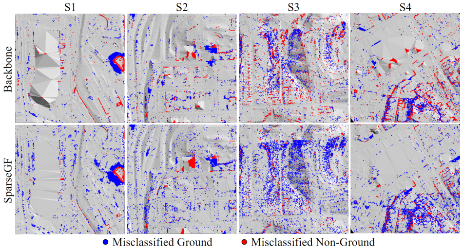
read the original abstract
High-quality digital terrain models derived from airborne laser scanning (ALS) data are essential for a wide range of geospatial analyses, and their generation typically relies on robust ground filtering (GF) to separate point clouds across diverse landscapes into ground and non-ground parts. Although current deep-learning-based GF methods have demonstrated impressive performance, especially in specific challenging terrains, their cross-scene generalization remains limited by two persistent issues: the context-detail dilemma in large-scale processing due to limited computational resources, and the random misclassification of tall objects arising from classification-only optimization. To overcome these limitations, we propose SparseGF, a height-aware sparse segmentation framework enhanced with context compression. It is built upon three key innovations: (1) a convex-mirror-inspired context compression module that condenses expansive contexts into compact representations while preserving central details; (2) a hybrid sparse voxel-point network architecture that effectively interprets compressed representations while mitigating compression-induced geometric distortion; and (3) a height-aware loss function that explicitly enforces topographic elevation priors during training to suppress random misclassification of tall objects. Extensive evaluations on two large-scale ALS benchmark datasets demonstrate that SparseGF delivers robust GF across urban to natural terrains, achieving leading performance in complex urban scenes, competitive results on mixed terrains, and moderate yet non-catastrophic accuracy in densely forested steep areas. This work offers new insights into deep-learning-based GF research and encourages further exploration toward truly cross-scene generalization for large-scale environmental monitoring.
Editorial analysis
A structured set of objections, weighed in public.
Referee Report
Summary. The paper proposes SparseGF, a deep-learning framework for ground filtering (GF) of airborne laser scanning (ALS) point clouds to separate ground and non-ground points across diverse landscapes. It introduces three innovations: a convex-mirror-inspired context compression module to condense large contexts while preserving central details, a hybrid sparse voxel-point network to interpret the compressed representations and mitigate geometric distortion, and a height-aware loss that incorporates topographic elevation priors to reduce random misclassifications of tall objects. Evaluations on two large-scale ALS benchmarks are reported to demonstrate robust cross-scene performance, with leading results in complex urban scenes, competitive results on mixed terrains, and moderate accuracy in densely forested steep areas.
Significance. If the central claims hold with proper validation, the work could meaningfully advance deep-learning-based ground filtering by addressing the context-detail trade-off and classification-only optimization issues that limit generalization. The proposed modules offer a concrete approach to efficient large-scale point-cloud processing and height-prior enforcement, which could improve digital terrain model generation for environmental monitoring; the emphasis on cross-scene robustness without scene-specific retraining would be a notable contribution if substantiated by appropriate splits and distortion metrics.
major comments (3)
- [§4 (Experiments)] §4 (Experiments): The cross-scene generalization claim requires explicit confirmation that training/test splits enforce terrain separation (e.g., train exclusively on urban data and test on natural/forested scenes). The current description does not provide this protocol detail, so the reported leading/competitive/moderate numbers cannot yet be attributed to the proposed modules rather than possible dataset overlap or mixed-distribution testing.
- [§3.1 (Context Compression Module)] §3.1 (Context Compression Module): No quantitative check of compression-induced geometric distortion is presented (e.g., pre/post-compression point fidelity, Chamfer distance, or normal error on recovered surfaces). Without such metrics, the claim that the hybrid voxel-point network effectively mitigates distortion remains unverified and load-bearing for the overall robustness argument.
- [§4.3 (Ablation Studies)] §4.3 (Ablation Studies): The abstract and results summary provide no ablation tables isolating the contribution of the context-compression module, the hybrid architecture, and the height-aware loss. This omission prevents assessment of whether each component is necessary for the reported performance gains.
minor comments (2)
- [Abstract] Abstract: The qualitative descriptors 'leading performance', 'competitive results', and 'moderate yet non-catastrophic accuracy' should be replaced or supplemented with concrete metrics (e.g., IoU, F1-score, or accuracy percentages with standard deviations) to enable direct comparison with prior work.
- [§3.3 (Height-Aware Loss)] Notation: The mathematical definition of the height-aware loss would benefit from an explicit equation showing how elevation priors are weighted relative to the standard segmentation loss, to avoid ambiguity in implementation.
Simulated Author's Rebuttal
We thank the referee for the constructive and detailed comments. We address each major point below and will revise the manuscript to strengthen the presentation of our claims and supporting evidence.
read point-by-point responses
-
Referee: [§4 (Experiments)] The cross-scene generalization claim requires explicit confirmation that training/test splits enforce terrain separation (e.g., train exclusively on urban data and test on natural/forested scenes). The current description does not provide this protocol detail, so the reported leading/competitive/moderate numbers cannot yet be attributed to the proposed modules rather than possible dataset overlap or mixed-distribution testing.
Authors: We agree that the data-split protocol must be stated explicitly to support the cross-scene generalization claims. The experiments were performed with strict terrain separation (urban scenes for training, natural/forested scenes for testing), but the manuscript description was insufficiently detailed. In the revision we will add a dedicated paragraph in §4 that specifies the exact partitioning procedure, confirms the absence of terrain overlap, and lists the scene identifiers used in each split. revision: yes
-
Referee: [§3.1 (Context Compression Module)] No quantitative check of compression-induced geometric distortion is presented (e.g., pre/post-compression point fidelity, Chamfer distance, or normal error on recovered surfaces). Without such metrics, the claim that the hybrid voxel-point network effectively mitigates distortion remains unverified and load-bearing for the overall robustness argument.
Authors: The referee is correct that quantitative distortion metrics would provide stronger verification of the hybrid network’s mitigation effect. Although the architecture was designed with this goal in mind, we did not report pre/post-compression fidelity measures in the initial submission. We will add these analyses—specifically Chamfer distance and surface-normal error computed on representative compressed and recovered point sets—to §3.1 and the supplementary material. revision: yes
-
Referee: [§4.3 (Ablation Studies)] The abstract and results summary provide no ablation tables isolating the contribution of the context-compression module, the hybrid architecture, and the height-aware loss. This omission prevents assessment of whether each component is necessary for the reported performance gains.
Authors: We acknowledge that comprehensive ablation tables are required to isolate the contribution of each proposed module. The original manuscript contained limited component-wise comparisons but lacked systematic ablation tables. We will expand §4.3 with new tables that successively disable the context-compression module, the hybrid voxel-point architecture, and the height-aware loss, reporting the resulting changes in accuracy, precision, and recall on both benchmarks. revision: yes
Circularity Check
No circularity: claims rest on novel modules and external benchmark evaluations
full rationale
The paper's derivation introduces three explicit architectural components (convex-mirror context compression, hybrid voxel-point network, height-aware loss) whose design is described independently of the target performance metrics. Performance assertions are tied to reported results on two named ALS benchmarks rather than any fitted parameter being relabeled as a prediction or any self-citation chain substituting for a proof. No equation or module definition reduces to its own output by construction, and the cross-scene claims are presented as empirical outcomes rather than tautological restatements of the inputs.
Axiom & Free-Parameter Ledger
Reference graph
Works this paper leans on
-
[1]
McCarley, T Ryan and Hudak, Andrew T and Sparks, Aaron M and Vaillant, Nicole M and Meddens, Arjan JH and Trader, Laura and Mauro, Francisco and Kreitler, Jason and Boschetti, Luigi , journal=. Estimating wildfire fuel consumption with multitemporal airborne laser scanning data and demonstrating linkage with
-
[2]
Automated forest inventory: Analysis of high-density airborne LiDAR point clouds with. Remote Sens. Environ. , volume =. 2024 , issn =
work page 2024
-
[3]
Muhadi, Nur Atirah and Abdullah, Ahmad Fikri and Bejo, Siti Khairunniza and Mahadi, Muhammad Razif and Mijic, Ana , journal=. The use of
-
[4]
Alin Mihu-Pintilie and Andrei Urzică and Cristian Constantin Stoleriu and Claudiu Ionut Pricop , title =. Geomat. Nat. Haz. RISK , volume =
-
[5]
Characterization and modeling of power line corridor elements from. ISPRS J. Photogramm. Remote Sens. , volume =. 2019 , author =
work page 2019
-
[6]
A review and future directions of techniques for extracting powerlines and pylons from LiDAR point clouds , journal =. 2024 , issn =
work page 2024
-
[7]
Beyond single receptive field: A receptive field fusion-and-stratification network for airborne laser scanning point cloud classification , journal =. 2022 , author =
work page 2022
- [8]
-
[9]
Capture And evaluation of Airborne Laser Scanner Data , author=. Int. Arch. Photogramm. Remote Sens. , year=
-
[10]
An improved simple morphological filter for the terrain classification of airborne
Pingel, Thomas J and Clarke, Keith C and McBride, William A , journal=. An improved simple morphological filter for the terrain classification of airborne
-
[11]
Slope based filtering of laser altimetry data , author=. Int. Arch. Photogramm. Remote Sens. , volume=
-
[12]
Filtering of laser altimetry data using a slope adaptive filter , author=. Int. Arch. Photogramm. Remote Sens. , volume=
-
[13]
Adaptive slope filtering of airborne
Susaki, Junichi , journal=. Adaptive slope filtering of airborne
-
[14]
ISPRS WG III/3, III/4, V/3 Workshop ``Laserscanning 2005" , volume=
Filtering of airborne laser scanner data based on segmented point clouds , author=. ISPRS WG III/3, III/4, V/3 Workshop ``Laserscanning 2005" , volume=
work page 2005
-
[15]
Hingee, K. and Caccetta, P. and Caccetta, L. and Wu, X. and Devereaux, D. , TITLE =. Int. Arch. Photogramm. Remote Sens. Spatial Inf. Sci. , VOLUME =. 2016 , PAGES =
work page 2016
-
[16]
Charles Beumier and Mahamadou Idrissa , title =. Int. J. Remote Sens. , volume =
-
[17]
Bartels, Marc and Wei, Hong and Mason, David C , booktitle=
-
[18]
IEEE J. Sel. Top. Appl. Earth Obs. Remote Sens. , volume=
-
[19]
Wei Su and Zhongping Sun and Ruofei Zhong and Jianxi Huang and Menglin Li and Jingguo Zhu and Keshu Zhang and Honggan Wu and Dehai Zhu , title =. Int. J. Remote Sens. , volume =
-
[20]
Improved progressive. ISPRS J. Photogramm. Remote Sens. , volume =. 2016 , issn =
work page 2016
-
[21]
A hybrid conditional random field for estimating the underlying ground surface from airborne
Lu, Wei-Lwun and Murphy, Kevin P and Little, James J and Sheffer, Alla and Fu, Hongbo , journal=. A hybrid conditional random field for estimating the underlying ground surface from airborne
-
[22]
A novel filtering algorithm for bare-earth extraction from airborne laser scanning data using an artificial neural network , author=. IEEE J. Sel. Top. Appl. Earth Obs. Remote Sens. , volume=
-
[23]
Deep-learning-based classification for
Hu, Xiangyun and Yuan, Yi , journal=. Deep-learning-based classification for
-
[24]
Rizaldy, Aldino and Persello, Claudio and Gevaert, Caroline and Oude Elberink, Sander and Vosselman, George , TITLE =. Remote Sens. , VOLUME =. 2018 , NUMBER =
work page 2018
-
[25]
Gevaert, Caroline and Persello, Claudio and Nex, Francesco and Vosselman, George , journal=. A deep learning approach to
-
[26]
Yotsumata, T. and Sakamoto, M. and Satoh, T. , TITLE =. Int. Arch. Photogramm. Remote Sens. Spatial Inf. Sci. , VOLUME =. 2020 , PAGES =
work page 2020
-
[27]
Fareed, Nadeem and Flores, Joao Paulo and Das, Anup Kumar , TITLE =. Remote Sens. , VOLUME =. 2023 , NUMBER =
work page 2023
-
[28]
A Point-Based Fully Convolutional Neural Network for Airborne
Jin, Shichao and Su, Yanjun and Zhao, Xiaoqian and Hu, Tianyu and Guo, Qinghua , journal=. A Point-Based Fully Convolutional Neural Network for Airborne. 2020 , volume=
work page 2020
-
[29]
Towards intelligent ground filtering of large-scale topographic point clouds: A comprehensive survey , journal =. 2023 , issn =
work page 2023
-
[30]
Choy, Christopher and Gwak, JunYoung and Savarese, Silvio , booktitle=
-
[31]
Qin, Nannan and Tan, Weikai and Ma, Lingfei and Zhang, Dedong and Li, Jonathan , booktitle=
-
[32]
Le Saux, Bertrand and Yokoya, Naoto and Haensch, Ronny and Brown, Myron , journal=. 2019 , volume=
work page 2019
- [33]
-
[34]
A progressive morphological filter for removing nonground measurements from airborne
Zhang, Keqi and Chen, Shu-Ching and Whitman, Dean and Shyu, Mei-Ling and Yan, Jianhua and Zhang, Chengcui , journal=. A progressive morphological filter for removing nonground measurements from airborne
-
[35]
Evans, Jeffrey S. and Hudak, Andrew T. , journal=. A Multiscale Curvature Algorithm for Classifying Discrete Return. 2007 , volume=
work page 2007
-
[36]
Zhang, Wuming and Qi, Jianbo and Wan, Peng and Wang, Hongtao and Xie, Donghui and Wang, Xiaoyan and Yan, Guangjian , journal=. An easy-to-use airborne
-
[37]
Qi, Charles Ruizhongtai and Yi, Li and Su, Hao and Guibas, Leonidas J , journal=. Point
-
[38]
Thomas, Hugues and Qi, Charles R and Deschaud, Jean-Emmanuel and Marcotegui, Beatriz and Goulette, Fran. Proc. IEEE Int. Conf. Comput. Vis. , pages=
-
[39]
Hu, Qingyong and Yang, Bo and Xie, Linhai and Rosa, Stefano and Guo, Yulan and Wang, Zhihua and Trigoni, Niki and Markham, Andrew , booktitle=
-
[40]
Fan, Siqi and Dong, Qiulei and Zhu, Fenghua and Lv, Yisheng and Ye, Peijun and Wang, Fei-Yue , title =. Proc. IEEE Conf. Comput. Vis. Pattern Recog. , month =. 2021 , pages =
work page 2021
-
[41]
Dai, Hengming and Hu, Xiangyun and Shu, Zhen and Qin, Nannan and Zhang, Jinming , TITLE =. Remote Sens. , VOLUME =. 2023 , NUMBER =
work page 2023
-
[42]
Deep learning for filtering the ground from
Qin, Nannan and Tan, Weikai and Ma, Lingfei and Zhang, Dedong and Guan, Haiyan and Li, Jonathan , journal=. Deep learning for filtering the ground from
- [43]
- [44]
-
[45]
The Lovasz-Softmax Loss: A Tractable Surrogate for the Optimization of the Intersection-Over-Union Measure in Neural Networks , author=. Proc. IEEE Conf. Comput. Vis. Pattern Recog. , year=
-
[46]
and Briese, Christian and Rieger, W
Pfeifer, Norbert and Reiter, T. and Briese, Christian and Rieger, W. , year =. Interpolation of high quality ground models from laser scanner data in forested areas , volume =
-
[47]
Semantic Labeling of ALS Point Cloud via Learning Voxel and Pixel Representations , author=. IEEE Geosci. Remote Sens. Lett. , volume=
-
[48]
Large-Scale ALS Point Cloud Segmentation via Projection-Based Context Embedding , year=
Dai, Hengming and Hu, Xiangyun and Zhang, Jinming and Shu, Zhen and Xu, Jiabo and Du, Juan , journal=. Large-Scale ALS Point Cloud Segmentation via Projection-Based Context Embedding , year=
-
[49]
A multi-scale fully convolutional network for semantic labeling of 3D point clouds , journal =. 2018 , author =
work page 2018
-
[50]
Addressing overfitting on point cloud classification using Atrous XCRF , journal =. 2019 , author =
work page 2019
-
[51]
Li, Jingxiang and Tang, Fuquan and Ma, Lingfei and Zhu, Chao and Gong, Zheng and Ruhaiyem, Nur Intan Raihana and Li, Jonathan , journal=. Point-SCT: A Multiscale Spatial Convolution-Swin Transformer Network for Point Cloud Ground Filtering in Complex Mountainous Terrains , year=
-
[52]
Behnaz Bigdeli and Hamed Amini Amirkolaee and Parham Pahlavani , journal=
-
[53]
A rapid high-resolution multi-sensory urban flood mapping framework via DEM upscaling. Remote Sens. Environ. , year=
-
[54]
Forested landslide detection using. Remote Sens. Environ. , volume =. 2014 , author =
work page 2014
-
[55]
Airborne laser scanning of forested landslides characterization: Terrain model quality and visualization , journal =. 2011 , author =
work page 2011
-
[56]
End-to-End High-Quality DEM Generation and Ground Filtering From ALS Point Clouds , year=
Xu, Jiabo and Dai, Hengming and Su, Bo and Wang, Pengfei and Hu, Xiangyun and Ke, Tao , journal=. End-to-End High-Quality DEM Generation and Ground Filtering From ALS Point Clouds , year=
-
[57]
author Amini Amirkolaee , H. , author Arefi, H. , author Ahmadlou, M. , author Raikwar, V. , year 2022 . title DTM extraction from DSM using a multi-scale DTM fusion strategy based on deep learning . journal Remote Sens. Environ. volume 274 , pages 113014
work page 2022
-
[58]
author Arief, H.A. , author Indahl, U.G. , author Strand, G.H. , author Tveite, H. , year 2019 . title Addressing overfitting on point cloud classification using atrous xcrf . journal ISPRS J. Photogramm. Remote Sens. volume 155 , pages 90--101
work page 2019
-
[59]
author Axelsson, P. , year 2000 . title DEM generation from laser scanner data using adaptive TIN models . journal Int. Arch. Photogramm. Remote Sens. volume XXXIII, Part B4 , pages 110--117
work page 2000
-
[60]
author Bartels, M. , author Wei, H. , author Mason, D.C. , year 2006 . title DTM generation from LiDAR data using skewness balancing , in: booktitle Proc. Int. Conf. on Pattern Recog. , pp. pages 566--569
work page 2006
-
[61]
author Berman, M. , author Triki, A.R. , author Blaschko, M.B. , year 2018 . title The lovasz-softmax loss: A tractable surrogate for the optimization of the intersection-over-union measure in neural networks , in: booktitle Proc. IEEE Conf. Comput. Vis. Pattern Recog. , pp. pages 4413--4421
work page 2018
-
[62]
author Beumier, C. , author Idrissa, M. , year 2016 . title Digital terrain models derived from digital surface model uniform regions in urban areas . journal Int. J. Remote Sens. volume 37 , pages 3477--3493
work page 2016
-
[63]
author Bigdeli, B. , author Amirkolaee, H.A. , author Pahlavani, P. , year 2018 . title DTM extraction under forest canopy using LiDAR data and a modified invasive weed optimization algorithm . journal Remote Sens. Environ. volume 216 , pages 289--300
work page 2018
-
[64]
author Chen, W. , author Li, X. , author Wang, Y. , author Chen, G. , author Liu, S. , year 2014 . title Forested landslide detection using LiDAR data and the random forest algorithm: A case study of the Three Gorges, China . journal Remote Sens. Environ. volume 152 , pages 291--301
work page 2014
-
[65]
author Choy, C. , author Gwak, J. , author Savarese, S. , year 2019 . title 4D spatio-temporal convnets: Minkowski convolutional neural networks , in: booktitle Proc. IEEE Conf. Comput. Vis. Pattern Recog. , pp. pages 3075--3084
work page 2019
-
[66]
author Dai, H. , author Hu, X. , author Shu, Z. , author Qin, N. , author Zhang, J. , year 2023 . title Deep ground filtering of large-scale ALS point clouds via iterative sequential ground prediction . journal Remote Sens. volume 15 , pages 961
work page 2023
-
[67]
author Dai, H. , author Hu, X. , author Zhang, J. , author Shu, Z. , author Xu, J. , author Du, J. , year 2024 . title Large-scale als point cloud segmentation via projection-based context embedding . journal IEEE Trans. Geosci. Remote Sens. volume 62 , pages 1--16
work page 2024
-
[68]
author Evans, J.S. , author Hudak, A.T. , year 2007 . title A multiscale curvature algorithm for classifying discrete return LiDAR in forested environments . journal IEEE Trans. Geosci. Remote Sens. volume 45 , pages 1029--1038
work page 2007
-
[69]
author Fan, S. , author Dong, Q. , author Zhu, F. , author Lv, Y. , author Ye, P. , author Wang, F.Y. , year 2021 . title SCF-Net : Learning spatial contextual features for large-scale point cloud segmentation , in: booktitle Proc. IEEE Conf. Comput. Vis. Pattern Recog. , pp. pages 14504--14513
work page 2021
-
[70]
author Fareed, N. , author Flores, J.P. , author Das, A.K. , year 2023 . title Analysis of UAS-LiDAR ground points classification in agricultural fields using traditional algorithms and PointCNN . journal Remote Sens. volume 15 , pages 483
work page 2023
-
[71]
author Gevaert, C. , author Persello, C. , author Nex, F. , author Vosselman, G. , year 2018 . title A deep learning approach to DTM extraction from imagery using rule-based training labels . journal ISPRS J. Photogramm. Remote Sens. volume 142 , pages 106--123
work page 2018
-
[72]
author Girshick, R. , year 2015 . title Fast R-CNN , in: booktitle Proc. IEEE Int. Conf. Comput. Vis. , pp. pages 1440--1448
work page 2015
-
[73]
author Hingee, K. , author Caccetta, P. , author Caccetta, L. , author Wu, X. , author Devereaux, D. , year 2016 . title Digital terrain from a two-step segmentation and outlier-based algorithm . journal Int. Arch. Photogramm. Remote Sens. Spatial Inf. Sci. volume XLI-B3 , pages 233--239
work page 2016
-
[74]
author Hu, Q. , author Yang, B. , author Xie, L. , author Rosa, S. , author Guo, Y. , author Wang, Z. , author Trigoni, N. , author Markham, A. , year 2020 . title RandLA-Net : Efficient semantic segmentation of large-scale point clouds , in: booktitle Proc. IEEE Conf. Comput. Vis. Pattern Recog. , pp. pages 11105--11114
work page 2020
-
[75]
author Hu, X. , author Yuan, Y. , year 2016 . title Deep-learning-based classification for DTM extraction from ALS point cloud . journal Remote sens. volume 8 , pages 730
work page 2016
-
[76]
author Jahromi, A.B. , author Zoej, M.J.V. , author Mohammadzadeh, A. , author Sadeghian, S. , year 2011 . title A novel filtering algorithm for bare-earth extraction from airborne laser scanning data using an artificial neural network . journal IEEE J. Sel. Top. Appl. Earth Obs. Remote Sens. volume 4 , pages 836--843
work page 2011
-
[77]
author Jin, S. , author Su, Y. , author Zhao, X. , author Hu, T. , author Guo, Q. , year 2020 . title A point-based fully convolutional neural network for airborne LiDAR ground point filtering in forested environments . journal IEEE J. Sel. Top. Appl. Earth Obs. Remote Sens. volume 13 , pages 3958--3974
work page 2020
-
[78]
author Kilian, J. , author Haala, N. , author Englich, M. , author Iii, C. , year 1996 . title Capture and evaluation of airborne laser scanner data . journal Int. Arch. Photogramm. Remote Sens. volume XXXI , pages 383--388
work page 1996
-
[79]
author Le Saux, B. , author Yokoya, N. , author Haensch, R. , author Brown, M. , year 2019 . title 2019 IEEE GRSS Data Fusion Contest : Large-scale semantic 3d reconstruction [technical committees] . journal IEEE Geosci. Remote Sens. Mag. volume 7 , pages 33--36
work page 2019
-
[80]
author Li, J. , author Tang, F. , author Ma, L. , author Zhu, C. , author Gong, Z. , author Ruhaiyem, N.I.R. , author Li, J. , year 2025 . title Point-sct: A multiscale spatial convolution-swin transformer network for point cloud ground filtering in complex mountainous terrains . journal IEEE Trans. Geosci. Remote Sens. volume 63 , pages 1--18
work page 2025
discussion (0)
Sign in with ORCID, Apple, or X to comment. Anyone can read and Pith papers without signing in.