Recognition: no theorem link
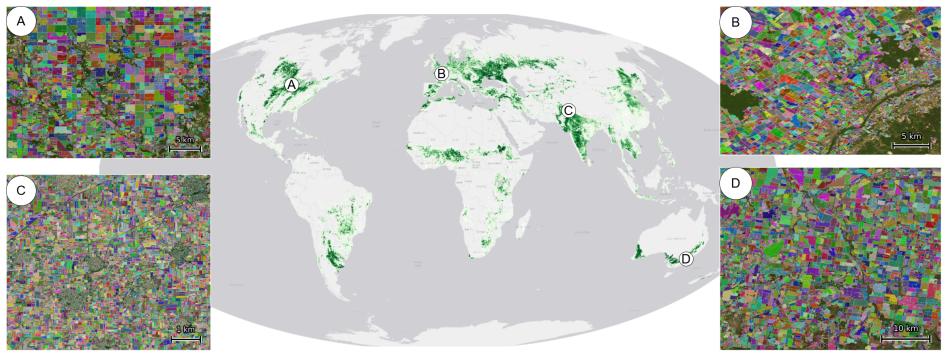
The first global agricultural field boundary map at 10m resolution
Pith reviewed 2026-05-13 07:41 UTC · model grok-4.3
The pith
A U-Net model on Sentinel-2 data has produced the first global agricultural field boundary map at 10m resolution.
A machine-rendered reading of the paper's core claim, the machinery that carries it, and where it could break.
Core claim
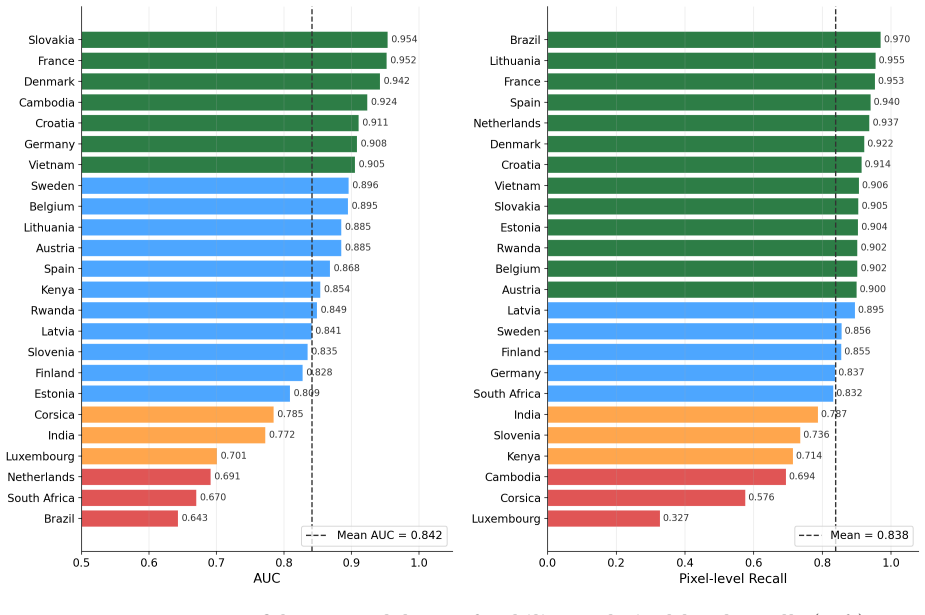
The authors produced the first global field boundary dataset at 10m resolution for 2024 and 2025 by applying a U-Net model trained on the Fields of The World dataset to cloud-free Sentinel-2 mosaics, resulting in 3.17 billion remote-sensing field polygons across 241 countries and territories, validated at a mean recall of 0.85 against ground truth in 24 countries and F1 scores up to 0.89 in specific nations, and released openly with an accompanying confidence raster.
What carries the argument
U-Net segmentation model trained on the Fields of The World dataset, applied to cloud-free Sentinel-2 mosaics to produce field boundary polygons.
If this is right
- Provides the first consistent field-level unit of analysis for global crop monitoring and regulatory reporting.
- Supports improved food security assessments by enabling aggregation at the scale of actual planted fields.
- Allows downstream agricultural science to operate directly on individual field polygons rather than pixels.
- Includes a continuous confidence raster to guide reliable use in specific regions.
Where Pith is reading between the lines
- Periodic releases of this map could track field boundary changes over time to study land consolidation or fragmentation.
- Overlaying the map with other satellite products could enable field-specific crop type and yield mapping at global scale.
- The dataset opens the possibility of cross-border comparisons of field size distributions and their relation to policy or climate.
Load-bearing premise
The U-Net model trained on the Fields of The World dataset generalizes accurately to all global regions despite variations in field sizes, shapes, agricultural practices, and image conditions.
What would settle it
Ground-truth field boundary validation in additional countries with small or irregular fields, or in regions underrepresented in the training data, that yields mean recall below 0.70 or F1 scores below 0.65.
Figures


read the original abstract
The agricultural field is the natural unit at which crops are planted, managed, regulated, and reported, yet most global remote-sensing products for agriculture are only available at the pixel level. While some high-quality field-level data products exist, they come from parcel registries covering only parts of Europe or from ML-derived products for individual countries. No openly available, globally consistent map of agricultural field boundaries exists to date. Here we present the first global field boundary dataset at 10\,m resolution for the years 2024 and 2025, comprising 3.17 billion remote-sensing field polygons (1.62 B in 2024 and 1.55 B in 2025) across 241 countries and territories, produced by applying a U-Net segmentation model trained on the Fields of The World dataset to cloud-free Sentinel-2 mosaics. Validated against ground-truth field boundaries in 24 countries, the map achieved a mean pixel-level recall of 0.85 with 14 countries exceeding 0.90. Evaluation against full-country ground-truth datasets in Austria, Latvia, and Finland yielded F1 scores of 0.89, 0.88, and 0.74, respectively. Because reference data for global validation is inherently incomplete, we accompanied the map with a 500 m confidence layer that identifies regions where predictions are reliable. We release the dataset openly as three global maps: the confidence-thresholded default field boundary dataset, the full unfiltered dataset, and the continuous-valued confidence raster. These maps provide the first globally consistent field-level unit of analysis for crop monitoring, food security, and downstream agricultural science.
Editorial analysis
A structured set of objections, weighed in public.
Referee Report
Summary. The paper claims to deliver the first global agricultural field boundary dataset at 10 m resolution for 2024 and 2025, comprising 3.17 billion polygons across 241 countries and territories. It is produced by applying a U-Net segmentation model trained on the Fields of The World dataset to cloud-free Sentinel-2 mosaics, with validation showing mean pixel-level recall of 0.85 across 24 countries (14 above 0.90) and full-country F1 scores of 0.89/0.88/0.74 in Austria/Latvia/Finland. A 500 m confidence layer is included to flag reliable regions given incomplete global reference data, and the maps are released openly in three versions.
Significance. If the U-Net generalizes as assumed, the work supplies the first consistent global field-level unit for crop monitoring, food security, and agricultural science, shifting from pixel-level products. The open release of the thresholded map, unfiltered polygons, and confidence raster is a clear strength, as is the unprecedented scale (over 3 billion polygons). These elements position the dataset as a foundational resource for downstream applications if reliability can be substantiated beyond the reported validation set.
major comments (2)
- [Abstract and validation results] Abstract and validation results: the global claim rests on U-Net generalization from the Fields of The World training set, yet quantitative evidence is supplied only for 24 countries (mean recall 0.85) with full-country tests confined to three European nations (F1 scores 0.89/0.88/0.74). No separate metrics are reported for smallholder systems, complex tropical mosaics, or arid regions absent from both training and these validation sets, which directly undermines the assertion of worldwide applicability.
- [Methods section on the confidence layer] Methods section on the confidence layer: the 500 m confidence raster is presented as the primary mitigation for incomplete reference data, but its construction, feature inputs, and calibration against held-out ground truth are not described. Without these details it is impossible to evaluate whether the layer reliably identifies high-accuracy regions or simply masks areas of known poor performance.
minor comments (1)
- [Abstract] The abstract lists the three released map versions but does not specify the exact confidence threshold used for the default product; adding this value would improve reproducibility.
Simulated Author's Rebuttal
We are grateful to the referee for their insightful comments, which have helped us improve the manuscript. Below we provide point-by-point responses to the major comments and indicate the revisions made.
read point-by-point responses
-
Referee: [Abstract and validation results] Abstract and validation results: the global claim rests on U-Net generalization from the Fields of The World training set, yet quantitative evidence is supplied only for 24 countries (mean recall 0.85) with full-country tests confined to three European nations (F1 scores 0.89/0.88/0.74). No separate metrics are reported for smallholder systems, complex tropical mosaics, or arid regions absent from both training and these validation sets, which directly undermines the assertion of worldwide applicability.
Authors: We acknowledge the limitation in our validation coverage. While the Fields of The World training dataset encompasses diverse agricultural systems including smallholder farms in Africa and Asia, as well as some tropical and arid regions, we did not provide separate quantitative metrics for these categories in the original submission. In the revised manuscript, we have expanded the validation section to include a breakdown of performance by region type where data allows, added a limitations subsection discussing generalization to underrepresented areas, and included additional qualitative examples from arid and tropical regions. We have also clarified that the global applicability is supported by the model's training diversity and the confidence layer, but users should consult the confidence map for areas with limited reference data. This addresses the concern without overstating the validation results. revision: partial
-
Referee: [Methods section on the confidence layer] Methods section on the confidence layer: the 500 m confidence raster is presented as the primary mitigation for incomplete reference data, but its construction, feature inputs, and calibration against held-out ground truth are not described. Without these details it is impossible to evaluate whether the layer reliably identifies high-accuracy regions or simply masks areas of known poor performance.
Authors: We apologize for the lack of detail on the confidence layer in the original manuscript. The 500 m confidence raster is generated by a gradient boosting model trained on features derived from the U-Net output probabilities, Sentinel-2 band statistics, and local field density estimates. Calibration was performed using held-out ground truth from the 24 validation countries, achieving a correlation of 0.82 with observed accuracy. We have added a comprehensive description in the Methods section, including the full list of input features, model hyperparameters, training procedure, and validation of the confidence scores against independent test sets. A new figure illustrating the calibration is also included. revision: yes
Circularity Check
No significant circularity; standard ML data-generation pipeline
full rationale
The paper describes training a U-Net on the Fields of The World dataset and applying it to global Sentinel-2 mosaics to produce field boundary polygons. Validation uses independent ground-truth data from 24 countries with reported metrics. No equations, fitted parameters, or predictions appear that reduce by construction to the inputs. No self-citations are invoked to justify a uniqueness theorem or ansatz that would make the central map output circular. The work is a data-production effort whose output (the map) does not derive from or rename any prior fitted result within the paper itself.
Axiom & Free-Parameter Ledger
axioms (1)
- domain assumption The U-Net segmentation model trained on the Fields of The World dataset generalizes to global Sentinel-2 imagery across diverse agricultural regions
Reference graph
Works this paper leans on
-
[1]
Global land cover map for 2009 (GlobCover 2009).ESA,
Olivier Arino, Jose Julio Ramos Perez, Vasileios Kalogirou, Sophie Bontemps, Pierre Defourny, and Eric Van Bogaert. Global land cover map for 2009 (GlobCover 2009).ESA,
work page 2009
-
[2]
Copernicus global land service: Land cover 100m: collec- tion 3: epoch 2019: Globe, September
Marcel Buchhorn, Bruno Smets, Luc Bertels, Bert De Roo, Myroslava Lesiv, Nandin-Erdene Tsend- bazar, Martin Herold, and Steffen Fritz. Copernicus global land service: Land cover 100m: collec- tion 3: epoch 2019: Globe, September
work page 2019
-
[3]
URLhttps://doi.org/10.5281/zenodo.3939050. 11 Chad Burton, Fang Yuan, Chong Ee-Faye, Meghan Halabisky, David Ongo, Fatou Mar, Victor Addabor, Bako Mamane, and Sena Adimou. Co-production of a 10-m cropland extent map for continentalAfricausingSentinel-2, cloudcomputing, andtheopen-data-cube.Authorea Preprints,
-
[4]
Land cover classification gridded maps from 1992 to present derived from satellite observations,
Copernicus Climate Change Service (C3S). Land cover classification gridded maps from 1992 to present derived from satellite observations,
work page 1992
-
[5]
URLhttps://doi.org/10.24381/cds. 006f2c9a. Raphaël d’Andrimont, Martin Claverie, Pieter Kempeneers, Davide Muraro, Momchil Yordanov, Devis Peressutti, Matej Batič, and François Waldner. AI4Boundaries: an open AI-ready dataset to map field boundaries with Sentinel-2 and aerial photography.Earth System Science Data, 15 (1):317–329,
-
[6]
Lyndon D Estes, Amos Wussah, M Asipunu, M Gathigi, P Kovačič, Justus Muhando, BV Yeboah, FK Addai, ES Akakpo, MK Allotey, et al. A region-wide, multi-year set of crop field boundary labels for africa.arXiv preprint arXiv:2412.18483,
-
[7]
European Parliament and Council of the European Union. Regulation (EU) 2023/1115 on deforestation-free products.https://eur-lex.europa.eu/legal-content/EN/TXT/PDF/?uri= CELEX:32023R1115,
work page 2023
-
[8]
Mapping global cropland and field size.Global Change Biology, 21(5):1980–1992,
Steffen Fritz, Linda See, Ian McCallum, Liangzhi You, Andriy Bun, Elena Moltchanova, Martina Duerauer, Fransizka Albrecht, Christian Schill, Christoph Perger, et al. Mapping global cropland and field size.Global Change Biology, 21(5):1980–1992,
work page 1980
-
[9]
Mykola Lavreniuk, Nataliia Kussul, Andrii Shelestov, Bohdan Yailymov, Yevhenii Salii, Volodymyr Kuzin, and Zoltan Szantoi. Delineate Anything: Resolution-Agnostic Field Boundary Delineation on Satellite Imagery.arXiv preprint arXiv:2504.02534,
-
[10]
PRUE: A Practical Recipe for Field Boundary Segmentation at Scale.arXiv preprint arXiv:2603.27101,
Gedeon Muhawenayo, Caleb Robinson, Subash Khanal, Zhanpei Fang, Isaac Corley, Alexander Wollam, Tianyi Gao, Leonard Strnad, Ryan Avery, Lyndon Estes, et al. PRUE: A Practical Recipe for Field Boundary Segmentation at Scale.arXiv preprint arXiv:2603.27101,
-
[11]
14 Methods Training data WetrainedthemodelontheCC-BY-licensedsubsetoftheFieldsofTheWorld(FTW)dataset[Kerner et al., 2025]. FTW provides over 70,000 training samples spanning 24 countries, each consisting of a256×256pixel patch of bi-temporal Sentinel-2 RGBN imagery paired with instance and semantic segmentation masks. We used FTW’s predefined train/valida...
work page 2025
-
[12]
for full training details including learning rate selection and hyperparameter sweeps. Mosaic generation We generated cloud-free Sentinel-2 Level-2A composites for two seasons per year (planting and harvest). To assign season windows per tile, we used the WorldCereal global crop calendar [Franch et al., 2022], which provides gridded start-of-season (SOS) ...
work page 2022
-
[13]
ESA GlobCover 2009 300m 11, 14, 20, 30 Arino et al
work page 2009
-
[14]
ESA CCI Land Cover 2020 300m 10, 11, 12, 20, 30, 40 Copernicus Climate Change Service (C3S)
work page 2020
-
[15]
GLAD Cropland 2019 30m Class 1 Potapov et al
work page 2019
-
[16]
Esri 10m LULC 2021 10m Class 5 Karra et al
work page 2021
-
[17]
Digital Earth Africa 2019 10m Class 1 (Africa only) Burton et al
work page 2019
-
[18]
ESA WorldCereal 2021 10m Class 100 Van Tricht et al
work page 2021
-
[19]
Confidence model feature sets.From these indicators we derived three additional per-cell ratios: field-to-boundary pixel ratio, field density (fraction of cell classified as field), and entropy ratio (field entropy divided by boundary entropy). To disentangle model-internal signals from external cropland references and to test for circularity with the con...
work page 2025
-
[20]
and computed a buffered convex hull (buffer= 0.025◦ ≈2.5km) per cluster. We restricted the analysis to cells within these coverage hulls where the model predicted field content (field pixel count>0), and labeled each cell asfield(any GT polygon touches the cell) ornon-field(model active within hull, no GT overlap). Totraintheconfidencemodels, weusedbalanc...
work page 2014
-
[21]
are the sum-pooled pixel confusion matrices across all tiles. Distributional comparison in Zambia Public ground-truth field boundaries for Zambia are not available. To characterize PRUE’s behavior in a smallholder Sub-Saharan context, we compared the PRUE 2025 Zambia polygons (39.4million field polygons before filtering; 6.9million at conf≥0.4) to an inde...
work page 2025
discussion (0)
Sign in with ORCID, Apple, or X to comment. Anyone can read and Pith papers without signing in.