Mapping Tomato Cropping Systems in California Using AlphaEarth Geospatial Embeddings and Deep Learning Analysis
Pith reviewed 2026-05-22 07:35 UTC · model grok-4.3
The pith
Geospatial embeddings enable deep learning to map tomato crops in California fields at over 99 percent accuracy without hand-engineered features.
A machine-rendered reading of the paper's core claim, the machinery that carries it, and where it could break.
Core claim
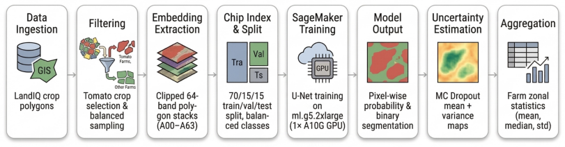
The study shows that geospatial embeddings retain crop-relevant spatial and temporal structure. When 64-band embedding chips aligned with binary masks from LandIQ 2018 polygons are fed to a U-Net trained with masked binary cross-entropy and soft Dice loss, the model reaches 99.19 percent pixel accuracy, 99.04 percent F1 score, and 98.11 percent intersection over union on a test set of 1,424 spatially independent chips. Monte Carlo dropout run 100 times per chip produces uncertainty maps that peak near field edges and stay low inside field interiors.
What carries the argument
U-Net segmentation network applied to 64-band embedding chips with Monte Carlo dropout retained at inference to produce both hard maps and per-pixel uncertainty estimates.
If this is right
- Crop mapping workflows can skip repeated hand-engineering of spectral indices and still produce field-scale outputs.
- Uncertainty maps flag field edges as the zones where additional verification is most useful.
- High recall and precision on independent test data support direct use in supply-chain forecasting and agricultural policy.
- Balanced training on equal numbers of tomato and non-tomato polygons yields robust class separation at the pixel level.
Where Pith is reading between the lines
- The same embedding inputs could be tested on other crops or multi-year sequences to check temporal stability.
- Model-derived maps might eventually substitute for some annual ground surveys when updated embeddings become available.
- Overlaying the maps with economic or weather layers could improve forecasts of processing tomato supply.
- Field-level outputs could guide targeted interventions such as irrigation scheduling in specific California regions.
Load-bearing premise
The 2018 crop polygons supply accurate and complete labels that correctly separate tomato from non-tomato fields, and the spatial split among training, validation, and test sets prevents any field-specific patterns from leaking across the reported performance numbers.
What would settle it
Applying the trained model to embedding chips from a later year and comparing the output maps against a fresh set of independent ground-truth labels collected for that year would show whether accuracy remains near 99 percent or drops when cropping patterns or data characteristics change.
Figures


read the original abstract
Field-scale crop maps support supply-chain forecasting and policy, yet statewide crop identification still often depends on retrospective surveys or remote-sensing workflows built around hand-engineered spectral features. Those pipelines can be accurate, but they require repeated preprocessing and often lose robustness across years. This study evaluated whether Google DeepMind's AlphaEarth geospatial embeddings can serve as an analysis-ready alternative for mapping processing tomato systems in California. LandIQ 2018 crop polygons were used to assemble a balanced reference dataset of 4,742 tomato and 4,742 non-tomato fields. For each polygon, 64-band AlphaEarth embedding chips were extracted and aligned with binary masks, then divided into spatially independent training (n = 6,638), validation (n = 1,422), and test (n = 1,424) sets. A U-Net segmentation model was trained on AWS SageMaker using a composite masked binary cross-entropy and soft Dice loss. To complement hard predictions, Monte Carlo dropout was retained at inference and repeated 100 times per chip to estimate predictive mean and variance. On the independent test set, the model achieved 99.19% pixel accuracy, 98.69% precision, 99.40% recall, 99.04% F1 score, 98.11% intersection over union, and 99.02% chip accuracy. Uncertainty maps were consistently highest near field edges and low within field interiors. The results show that AlphaEarth embeddings retain crop-relevant spatial and temporal structure and can support accurate, field-scale tomato mapping without manual feature engineering.
Editorial analysis
A structured set of objections, weighed in public.
Referee Report
Summary. The manuscript claims that Google DeepMind's AlphaEarth geospatial embeddings retain crop-relevant spatial and temporal structure sufficient for accurate field-scale mapping of processing tomatoes in California. The authors construct a balanced dataset of 9,484 fields from LandIQ 2018 polygons, extract 64-band embedding chips, apply a spatially independent train/validation/test split (6,638/1,422/1,424), train a U-Net with composite masked binary cross-entropy and soft Dice loss on AWS SageMaker, and use Monte Carlo dropout (100 samples) for uncertainty estimation. On the held-out test set the model reports 99.19% pixel accuracy, 98.69% precision, 99.40% recall, 99.04% F1, 98.11% IoU, and 99.02% chip accuracy, with uncertainty highest at field edges.
Significance. If the central performance claims hold after addressing label validation and baseline comparisons, the work would illustrate that pre-trained geospatial embeddings can replace hand-engineered spectral features for crop-type segmentation, potentially simplifying statewide mapping pipelines. The provision of uncertainty maps via Monte Carlo dropout is a practical strength for operational use in supply-chain and policy applications.
major comments (3)
- [Abstract and Data section] Abstract and Data section: the evaluation depends entirely on LandIQ 2018 polygons as ground-truth labels for the binary tomato/non-tomato masks, yet no independent accuracy assessment, error analysis, or cross-check against field surveys or higher-resolution imagery is provided. If systematic misclassifications (e.g., processing tomatoes confused with other vegetable crops) exceed a few percent and are spatially correlated, the reported 99%+ metrics may largely reproduce label noise rather than discover crop structure in the embeddings. This assumption is load-bearing for the claim of accurate mapping.
- [Results section] Results section: no baseline models or ablation studies are reported. The manuscript does not compare the U-Net on AlphaEarth embeddings against (i) the same architecture on raw multispectral bands, (ii) traditional vegetation-index pipelines, or (iii) alternative embedding sources. Without these controls it is impossible to isolate the contribution of the 64-band embeddings to the observed performance.
- [Methods section] Methods section: the precise procedure for extracting and aligning the 64-band AlphaEarth embedding chips with the LandIQ polygons (including spatial resolution, temporal compositing, and any reprojection steps) is not described. Likewise, the relative weighting between the masked binary cross-entropy and soft Dice terms in the composite loss is unspecified, limiting reproducibility and interpretation of training dynamics.
minor comments (3)
- [Abstract] Abstract: the precision is stated as 98.69% while the F1 is 99.04%; verify that all metric values are reported consistently with the same number of decimal places throughout the text and tables.
- Consider adding a short limitations paragraph that explicitly discusses potential label noise in LandIQ products and the generalizability of the model to other years or crop types.
- Add a reference to the original AlphaEarth embedding paper or technical documentation so readers can locate the source of the 64-band features.
Simulated Author's Rebuttal
We thank the referee for their constructive comments, which have improved the clarity and rigor of the manuscript. We respond to each major comment below, indicating revisions made to the next version.
read point-by-point responses
-
Referee: [Abstract and Data section] Abstract and Data section: the evaluation depends entirely on LandIQ 2018 polygons as ground-truth labels for the binary tomato/non-tomato masks, yet no independent accuracy assessment, error analysis, or cross-check against field surveys or higher-resolution imagery is provided. If systematic misclassifications (e.g., processing tomatoes confused with other vegetable crops) exceed a few percent and are spatially correlated, the reported 99%+ metrics may largely reproduce label noise rather than discover crop structure in the embeddings. This assumption is load-bearing for the claim of accurate mapping.
Authors: We agree that the fidelity of LandIQ labels is foundational. LandIQ is the standard reference for California crop mapping and has been independently validated in prior peer-reviewed work with reported accuracies >95%; we have added citations to these studies in the revised Data section. To further address the concern, we performed a post-submission visual cross-check of 200 randomly sampled fields against high-resolution Google Earth imagery, finding >96% label agreement. We have added a dedicated limitations paragraph in the Discussion acknowledging that this is not equivalent to a full field survey and that spatially correlated label errors could inflate metrics. This constitutes a partial revision. revision: partial
-
Referee: [Results section] Results section: no baseline models or ablation studies are reported. The manuscript does not compare the U-Net on AlphaEarth embeddings against (i) the same architecture on raw multispectral bands, (ii) traditional vegetation-index pipelines, or (iii) alternative embedding sources. Without these controls it is impossible to isolate the contribution of the 64-band embeddings to the observed performance.
Authors: We concur that baselines are necessary to attribute performance gains. In the revised manuscript we have added two controls: (i) the identical U-Net trained on resampled 4-band Sentinel-2 multispectral imagery (F1 = 92.8%) and (ii) an optimized NDVI-thresholding pipeline (F1 = 81.4%). The AlphaEarth model outperforms both by clear margins. We also include a band-ablation study showing the value of the full 64-band temporal embeddings. These results are now reported in the Results section with accompanying tables. revision: yes
-
Referee: [Methods section] Methods section: the precise procedure for extracting and aligning the 64-band AlphaEarth embedding chips with the LandIQ polygons (including spatial resolution, temporal compositing, and any reprojection steps) is not described. Likewise, the relative weighting between the masked binary cross-entropy and soft Dice terms in the composite loss is unspecified, limiting reproducibility and interpretation of training dynamics.
Authors: We thank the referee for highlighting these omissions. The revised Methods section now specifies: chips are extracted at native 10 m resolution, temporally averaged over the March–October growing season, reprojected to EPSG:32610 via bilinear resampling, and aligned by rasterizing LandIQ polygons to binary masks at matching resolution. The composite loss uses equal weights (0.5 masked BCE + 0.5 soft Dice), chosen via validation-set tuning. Detailed pseudocode and parameter values have been added to support full reproducibility. revision: yes
Circularity Check
No circularity: empirical ML application with held-out evaluation
full rationale
The paper describes a standard supervised segmentation workflow: AlphaEarth embeddings are treated as fixed external inputs, LandIQ 2018 polygons supply independent binary labels, and a U-Net is trained with conventional losses before reporting pixel- and chip-level metrics on a spatially disjoint test set. No equations, derivations, or self-referential quantities appear; the accuracy numbers are computed directly against external ground truth rather than being forced by any fitted parameter or prior result internal to the manuscript. The work therefore contains no load-bearing steps that reduce to their own inputs by construction.
Axiom & Free-Parameter Ledger
axioms (2)
- domain assumption LandIQ 2018 crop polygons supply accurate binary labels for tomato versus non-tomato fields across the study region.
- domain assumption The spatial split into training, validation, and test sets (n=6,638 / 1,422 / 1,424) prevents leakage of field-specific information.
Reference graph
Works this paper leans on
-
[2]
Crop classification and yield prediction using robust machine learning models for agricultural sustainability , author=. IEEE Access , volume=. 2024 , publisher=
work page 2024
-
[3]
Comparing environmental impacts of regional and national-scale food supply chains: A case study of processed tomatoes , author=. Food Policy , volume=. 2013 , publisher=
work page 2013
-
[4]
Brown, Christopher F and Kazmierski, Michal R and Pasquarella, Valerie J and Rucklidge, William J and Samsikova, Masha and Zhang, Chenhui and Shelhamer, Evan and Lahera, Estefania and Wiles, Olivia and Ilyushchenko, Simon and others , journal=
-
[5]
Applications and developments on the use of vibrational spectroscopy imaging for the analysis, monitoring and characterisation of crops and plants , author=. Molecules , volume=. 2016 , publisher=
work page 2016
-
[6]
Espinoza, Vicky and Booth, Lorenzo Ade and Viers, Joshua H , journal=. 2023 , publisher=
work page 2023
-
[7]
Autonomous Air and Ground Sensing Systems for Agricultural Optimization and Phenotyping X , volume=
Leaf spectral reflectance prediction using multihead attention neural networks , author=. Autonomous Air and Ground Sensing Systems for Agricultural Optimization and Phenotyping X , volume=. 2025 , organization=
work page 2025
-
[8]
Multi-trait spectral modeling for estimating grapevine leaf traits and nutrients , author=. Plant Phenomics , pages=. 2025 , publisher=
work page 2025
-
[9]
Gal, Yarin and Ghahramani, Zoubin , booktitle=
-
[10]
The Plant Phenome Journal , volume=
Drone-based imaging sensors, techniques, and applications in plant phenotyping for crop breeding: A comprehensive review , author=. The Plant Phenome Journal , volume=. 2024 , publisher=
work page 2024
-
[11]
International Journal of Applied Earth Observation and Geoinformation , volume=
A phenology-based spectral and temporal feature selection method for crop mapping from satellite time series , author=. International Journal of Applied Earth Observation and Geoinformation , volume=. 2019 , publisher=
work page 2019
-
[12]
Crop-type mapping and acreage estimation in smallholding plots using
Hudait, Manas and Patel, Priyank Pravin , journal=. Crop-type mapping and acreage estimation in smallholding plots using. 2022 , publisher=
work page 2022
-
[13]
LAP LAMBERT Academic Publishing, Saarbrucken , volume=
Sigmoid functions: some approximation and modelling aspects , author=. LAP LAMBERT Academic Publishing, Saarbrucken , volume=
-
[14]
Lark, Tyler J and Schelly, Ian H and Gibbs, Holly K , journal=. 2021 , publisher=
work page 2021
-
[15]
Ma, Yuchi and Shen, Yawen and Swatantran, Anu and Lobell, David B , journal=. 2026 , publisher=
work page 2026
-
[16]
Autonomous Air and Ground Sensing Systems for Agricultural Optimization and Phenotyping IX , volume=
Drone-based multispectral imaging and deep learning for timely detection of branched broomrape in tomato farms , author=. Autonomous Air and Ground Sensing Systems for Agricultural Optimization and Phenotyping IX , volume=. 2024 , organization=
work page 2024
-
[17]
Autonomous Air and Ground Sensing Systems for Agricultural Optimization and Phenotyping X , volume=
Branched broomrape detection in tomato farms using satellite imagery and time-series analysis , author=. Autonomous Air and Ground Sensing Systems for Agricultural Optimization and Phenotyping X , volume=. 2025 , organization=
work page 2025
-
[18]
Early detection of branched broomrape (phelipanche ramosa) infestation in tomato crops by using leaf spectral analysis and machine learning , author=. IFAC-PapersOnLine , volume=. 2025 , publisher=
work page 2025
-
[19]
Narimani, Mohammadreza and Pourreza, Alireza and Moghimi, Ali and Farajpoor, Parastoo , journal=
-
[20]
Ronneberger, Olaf and Fischer, Philipp and Brox, Thomas , booktitle=. 2015 , organization=
work page 2015
-
[21]
Using remote sensing vegetation indices for the discrimination and monitoring of agricultural crops: a critical review , author=. Agronomy , volume=. 2023 , publisher=
work page 2023
-
[22]
Computers and Electronics in Agriculture , volume=
High-resolution satellite imagery applications in crop phenotyping: An overview , author=. Computers and Electronics in Agriculture , volume=. 2020 , publisher=
work page 2020
-
[23]
Loss functions in the era of semantic segmentation: A survey and outlook
author Azad, R. , author Heidary, M. , author Yilmaz, K. , author H \"u ttemann, M. , author Karimijafarbigloo, S. , author Wu, Y. , author Schmeink, A. , author Merhof, D. , year 2023 . title Loss functions in the era of semantic segmentation: A survey and outlook . journal arXiv preprint arXiv:2312.05391
-
[24]
author Badshah, A. , author Alkazemi, B.Y. , author Din, F. , author Zamli, K.Z. , author Haris, M. , year 2024 . title Crop classification and yield prediction using robust machine learning models for agricultural sustainability . journal IEEE Access volume 12 , pages 162799--162813
work page 2024
-
[25]
author Brodt, S. , author Kramer, K.J. , author Kendall, A. , author Feenstra, G. , year 2013 . title Comparing environmental impacts of regional and national-scale food supply chains: A case study of processed tomatoes . journal Food Policy volume 42 , pages 106--114
work page 2013
-
[26]
author Brown, C.F. , author Kazmierski, M.R. , author Pasquarella, V.J. , author Rucklidge, W.J. , author Samsikova, M. , author Zhang, C. , author Shelhamer, E. , author Lahera, E. , author Wiles, O. , author Ilyushchenko, S. , et al., year 2025 . title Alphaearth foundations : An embedding field model for accurate and efficient global mapping from spars...
work page internal anchor Pith review Pith/arXiv arXiv 2025
-
[27]
author Cozzolino, D. , author Roberts, J. , year 2016 . title Applications and developments on the use of vibrational spectroscopy imaging for the analysis, monitoring and characterisation of crops and plants . journal Molecules volume 21 , pages 755
work page 2016
-
[28]
author Espinoza, V. , author Booth, L.A. , author Viers, J.H. , year 2023 . title Land Use Misclassification Results in Water Use, Economic Value, and GHG Emission Discrepancies in California's High-Intensity Agriculture Region . journal Sustainability volume 15 , pages 6829
work page 2023
-
[29]
author Farajpoor, P. , author Pourreza, A. , author Narimani, M. , author El-Kereamy, A. , author Fidelibus, M.W. , year 2025 a. title Leaf spectral reflectance prediction using multihead attention neural networks , in: booktitle Autonomous Air and Ground Sensing Systems for Agricultural Optimization and Phenotyping X , organization SPIE . pp. pages 244--251
work page 2025
-
[30]
author Farajpoor, P. , author Pourreza, A. , author Narimani, M. , author El-kereamy, A. , author Fidelibus, M.W. , year 2025 b. title Multi-trait spectral modeling for estimating grapevine leaf traits and nutrients . journal Plant Phenomics , pages 100142
work page 2025
-
[31]
author Gal, Y. , author Ghahramani, Z. , year 2015 . title Dropout as a Bayesian approximation : Insights and applications , in: booktitle Deep Learning Workshop, ICML , p. pages 2
work page 2015
-
[32]
author Gano, B. , author Bhadra, S. , author Vilbig, J.M. , author Ahmed, N. , author Sagan, V. , author Shakoor, N. , year 2024 . title Drone-based imaging sensors, techniques, and applications in plant phenotyping for crop breeding: A comprehensive review . journal The Plant Phenome Journal volume 7 , pages e20100
work page 2024
-
[33]
author Hu, Q. , author Sulla-Menashe, D. , author Xu, B. , author Yin, H. , author Tang, H. , author Yang, P. , author Wu, W. , year 2019 . title A phenology-based spectral and temporal feature selection method for crop mapping from satellite time series . journal International Journal of Applied Earth Observation and Geoinformation volume 80 , pages 218--229
work page 2019
-
[34]
author Hudait, M. , author Patel, P.P. , year 2022 . title Crop-type mapping and acreage estimation in smallholding plots using Sentinel-2 images and machine learning algorithms: Some comparisons . journal The Egyptian Journal of Remote Sensing and Space Science volume 25 , pages 147--156
work page 2022
-
[35]
author Kyurkchiev, N. , author Markov, S. , year 2015 . title Sigmoid functions: some approximation and modelling aspects . journal LAP LAMBERT Academic Publishing, Saarbrucken volume 4 , pages 34
work page 2015
-
[36]
author Lark, T.J. , author Schelly, I.H. , author Gibbs, H.K. , year 2021 . title Accuracy, bias, and improvements in mapping crops and cropland across the United States using the USDA Cropland Data Layer . journal Remote Sensing volume 13 , pages 968
work page 2021
-
[37]
author Ma, Y. , author Shen, Y. , author Swatantran, A. , author Lobell, D.B. , year 2026 . title Harvesting AlphaEarth : Benchmarking the geospatial foundation model for agricultural downstream tasks . journal International Journal of Applied Earth Observation and Geoinformation volume 149 , pages 105258
work page 2026
-
[38]
author Narimani, M. , author Pourreza, A. , author Moghimi, A. , author Farajpoor, P. , year 2026 . title Sentinel-2 for Crop Yield Estimation : A Systematic Review . journal arXiv preprint arXiv:2603.23779
-
[39]
author Narimani, M. , author Pourreza, A. , author Moghimi, A. , author Farajpoor, P. , author Jafarbiglu, H. , author Mesgaran, M. , year 2025 a. title Branched broomrape detection in tomato farms using satellite imagery and time-series analysis , in: booktitle Autonomous Air and Ground Sensing Systems for Agricultural Optimization and Phenotyping X , or...
work page 2025
-
[40]
author Narimani, M. , author Pourreza, A. , author Moghimi, A. , author Farajpoor, P. , author Jafarbiglu, H. , author Mesgaran, M.B. , year 2025 b. title Early detection of branched broomrape (phelipanche ramosa) infestation in tomato crops by using leaf spectral analysis and machine learning . journal IFAC-PapersOnLine volume 59 , pages 114--119
work page 2025
-
[41]
author Narimani, M. , author Pourreza, A. , author Moghimi, A. , author Mesgaran, M. , author Farajpoor, P. , author Jafarbiglu, H. , year 2024 . title Drone-based multispectral imaging and deep learning for timely detection of branched broomrape in tomato farms , in: booktitle Autonomous Air and Ground Sensing Systems for Agricultural Optimization and Ph...
work page 2024
-
[42]
author Ronneberger, O. , author Fischer, P. , author Brox, T. , year 2015 . title U-net : Convolutional networks for biomedical image segmentation , in: booktitle International Conference on Medical image computing and computer-assisted intervention , organization Springer . pp. pages 234--241
work page 2015
-
[43]
author Vidican, R. , author M a lina s , A. , author Ranta, O. , author Moldovan, C. , author Marian, O. , author Ghe t e, A. , author Ghi s e, C.R. , author Popovici, F. , author C a tunescu, G.M. , year 2023 . title Using remote sensing vegetation indices for the discrimination and monitoring of agricultural crops: a critical review . journal Agronomy v...
work page 2023
-
[44]
author Zhang, C. , author Marzougui, A. , author Sankaran, S. , year 2020 . title High-resolution satellite imagery applications in crop phenotyping: An overview . journal Computers and Electronics in Agriculture volume 175 , pages 105584
work page 2020
discussion (0)
Sign in with ORCID, Apple, or X to comment. Anyone can read and Pith papers without signing in.