From Local Training to Large-Scale Mapping: A Comparative Assessment of Machine Learning and Deep Learning for Transferable Satellite-Derived Bathymetry
Pith reviewed 2026-06-28 14:47 UTC · model grok-4.3
The pith
Deep learning models maintain robust performance for satellite bathymetry across different coastal regions while Random Forest degrades.
A machine-rendered reading of the paper's core claim, the machinery that carries it, and where it could break.
Core claim
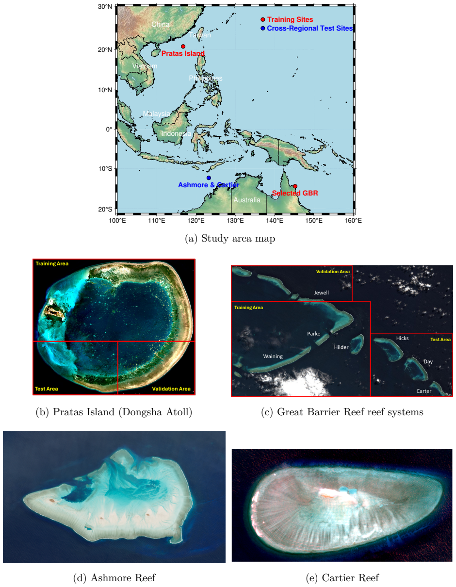
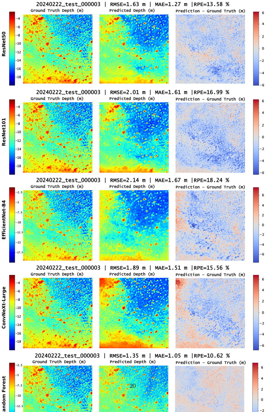
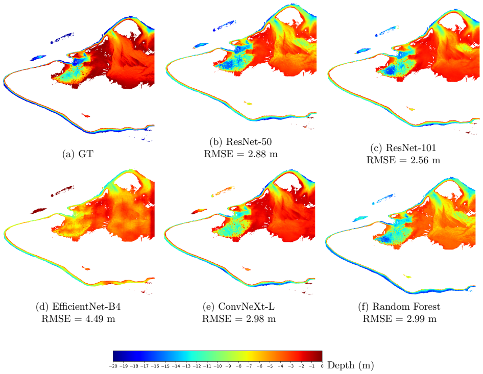
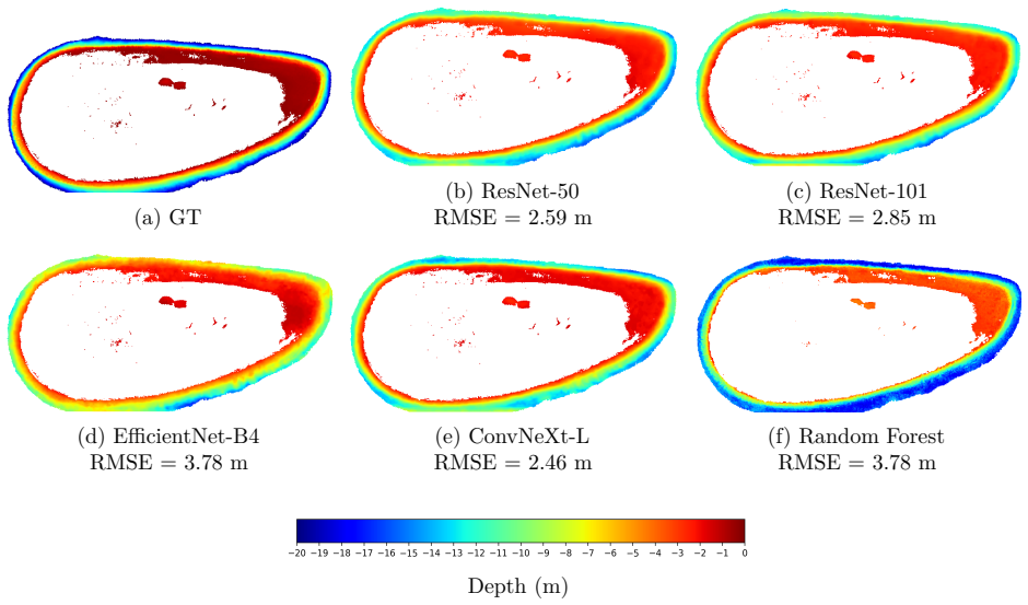
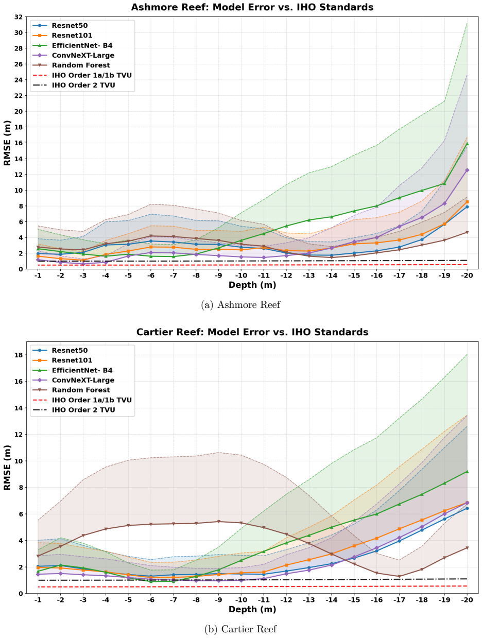
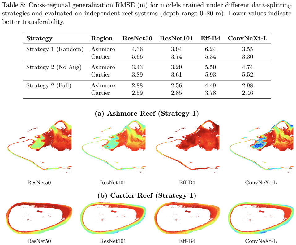
The central claim is that four CNN architectures trained with spatially continuous blocks and a Smooth Weight Function weighted RMSE loss produce transferable bathymetry estimates from Sentinel-2 multispectral imagery, achieving cross-regional RMSE of 2.46-2.98 m over 0-20 m depths compared to Random Forest degradation, and 0.19-0.22 m RMSE on the MagicBathyNet benchmark.
What carries the argument
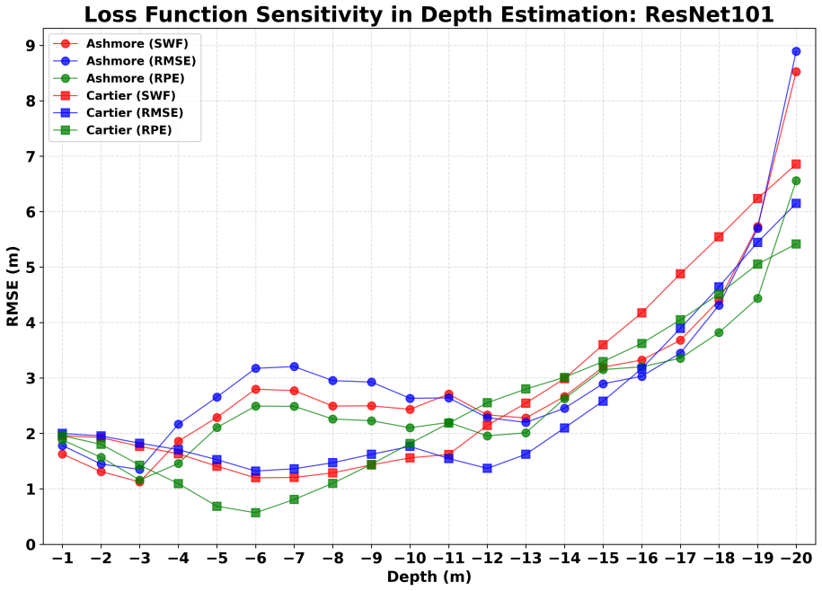
The Smooth Weight Function (SWF)-weighted RMSE loss that prioritizes near-surface depths, paired with training on contiguous spatial blocks to preserve reef continuity.
If this is right
- Intra-regional tests show RMSE from 1.15 to 1.92 m over 0-20 m depths, dropping to 0.26 m for depths under 3 m.
- Median aggregation of predictions from multiple image passes reduces noise from sun angle, atmosphere, water, and tides.
- The networks outperform a U-Net baseline and a task-specific transformer on the MagicBathyNet aerial benchmark with fewer parameters.
- Optimized architectures and pretrained weights are released to support application at new sites.
Where Pith is reading between the lines
- Such models could support repeated mapping of shallow waters worldwide using freely available Sentinel-2 data without needing local training data each time.
- The emphasis on spatial continuity in training data may apply to other remote sensing tasks where random sampling breaks important patterns.
- Extending the approach to include additional sensors or wavelengths might address limitations in very turbid or complex waters.
Load-bearing premise
The training regions chosen represent a broad enough sample of coastal optical conditions to ensure the models generalize to arbitrary new areas.
What would settle it
A test on a coastal region with water properties or bottom reflectance outside the range seen in the Pratas Island and Great Barrier Reef training data where deep model RMSE rises above 3.5 m while Random Forest stays comparable.
Figures
read the original abstract
Satellite-derived bathymetry (SDB) from multispectral imagery is cost-effective but scales poorly across regions, especially in optically complex coastal environments. We evaluate machine learning and deep learning for transferable SDB over the 0-20 m depth range using Sentinel-2 imagery. A Random Forest baseline and four CNNs (ResNet-50, ResNet-101, EfficientNet-B4, ConvNeXt-Large) are trained on Pratas Island and selected Great Barrier Reef regions, then evaluated on spatially independent intra- and cross-regional test areas. Preserving spatial continuity during training, by keeping contiguous reef blocks rather than random patches, is the single most impactful design choice; we further introduce a Smooth Weight Function (SWF)-weighted RMSE loss that emphasizes near-surface depths. With these choices, intra-regional RMSE ranges from 1.15 to 1.92 m over 0-20 m and is as low as 0.26 m for depths <= 3 m. Random Forest degrades sharply under cross-regional transfer (RMSE 1.53 m -> 2.99-3.78 m), while the deep models stay more robust (2.46-2.98 m). On the public MagicBathyNet aerial-RGB benchmark (0-16 m) the proposed networks reach 0.19-0.22 m RMSE, outperforming a U-Net baseline and a task-specific transformer architecture with substantially fewer parameters. We further exploit multi-temporal repeat imagery: training on it broadens diversity, and median-aggregating predictions across passes at inference reduces noise from changing sun angles, atmospheric conditions, water properties, and tides. We release optimized architectures and pretrained weights to enable scalable transfer to new sites.
Editorial analysis
A structured set of objections, weighed in public.
Referee Report
Summary. The manuscript evaluates Random Forest and four CNN architectures (ResNet-50, ResNet-101, EfficientNet-B4, ConvNeXt-Large) for satellite-derived bathymetry from Sentinel-2 imagery over 0-20 m depths. Models are trained on Pratas Island and selected Great Barrier Reef blocks with contiguous spatial blocks preserved and a Smooth Weight Function (SWF)-weighted RMSE loss; they are tested on spatially independent intra- and cross-regional areas. The central empirical claims are that DL models retain RMSE of 2.46-2.98 m under cross-regional transfer while RF degrades to 2.99-3.78 m, intra-regional RMSE reaches 1.15-1.92 m (0.26 m for ≤3 m), and the networks achieve 0.19-0.22 m RMSE on the MagicBathyNet aerial-RGB benchmark, outperforming a U-Net and a transformer baseline. Multi-temporal aggregation is shown to reduce noise, and pretrained weights are released.
Significance. If the cross-regional robustness claims hold after addressing site-diversity characterization, the work would be significant for practical SDB scaling, as it directly targets the known limitation of poor generalization across optically complex coastal sites. The release of optimized architectures and pretrained weights is a clear strength for reproducibility. The emphasis on preserving spatial continuity during training and the SWF loss are useful methodological contributions that could be adopted more broadly.
major comments (2)
- [cross-regional transfer evaluation] Cross-regional transfer evaluation (abstract and corresponding results section): The claim that DL models maintain robustness (RMSE 2.46-2.98 m) while RF degrades (2.99-3.78 m) is load-bearing for the transferability conclusion, yet no quantitative metrics are provided characterizing differences between training sites (Pratas Island, selected GBR blocks) and test areas in optical properties, water clarity (e.g., Secchi depth), chlorophyll-a, sediment load, or bottom-type distributions. Without such evidence, retained performance could reflect site similarity rather than model generalization.
- [MagicBathyNet benchmark] MagicBathyNet benchmark results (abstract): The reported 0.19-0.22 m RMSE on aerial RGB imagery (0-16 m) is presented as supporting evidence, but this dataset and sensor type do not directly test the Sentinel-2 multispectral cross-regional transfer scenario that forms the paper's primary claim; the two evaluations therefore address distinct transfer problems.
minor comments (1)
- [abstract] Abstract: The intra-regional RMSE range (1.15-1.92 m) is given without per-model or per-depth-band breakdown, making it difficult to assess which architecture drives the best results.
Simulated Author's Rebuttal
We thank the referee for the constructive comments. We address each major point below, agreeing where the manuscript can be strengthened and clarifying the role of each evaluation.
read point-by-point responses
-
Referee: [cross-regional transfer evaluation] Cross-regional transfer evaluation (abstract and corresponding results section): The claim that DL models maintain robustness (RMSE 2.46-2.98 m) while RF degrades (2.99-3.78 m) is load-bearing for the transferability conclusion, yet no quantitative metrics are provided characterizing differences between training sites (Pratas Island, selected GBR blocks) and test areas in optical properties, water clarity (e.g., Secchi depth), chlorophyll-a, sediment load, or bottom-type distributions. Without such evidence, retained performance could reflect site similarity rather than model generalization.
Authors: We agree that explicit quantitative characterization of optical and environmental differences would strengthen the generalization argument. The training (Pratas Island, selected GBR blocks) and cross-regional test areas are drawn from geographically distinct locations known to differ in water properties, but the original manuscript did not include a dedicated comparison table. In revision we will add a supplementary table compiling available Secchi depth, chlorophyll-a, and bottom-type information from public datasets and literature for all sites to quantify the degree of difference. revision: yes
-
Referee: [MagicBathyNet benchmark] MagicBathyNet benchmark results (abstract): The reported 0.19-0.22 m RMSE on aerial RGB imagery (0-16 m) is presented as supporting evidence, but this dataset and sensor type do not directly test the Sentinel-2 multispectral cross-regional transfer scenario that forms the paper's primary claim; the two evaluations therefore address distinct transfer problems.
Authors: We agree that the MagicBathyNet results address transfer to aerial RGB rather than Sentinel-2 multispectral imagery and therefore constitute supplementary rather than primary evidence for the Sentinel-2 cross-regional claims. The core transferability results remain the Sentinel-2 intra- and cross-regional tests. We will revise the abstract and discussion to explicitly label the MagicBathyNet evaluation as additional validation on a different sensor and data modality. revision: yes
Circularity Check
No circularity: purely empirical evaluation on independent test sets
full rationale
The paper reports RMSE values from training CNNs and Random Forest on Pratas Island/Great Barrier Reef imagery and evaluating on spatially independent intra- and cross-regional test areas plus the external MagicBathyNet benchmark. No equations, derivations, fitted parameters renamed as predictions, or self-citation chains appear in the provided text. All performance claims are direct measurements on held-out data; the SWF-weighted loss is an explicit design choice, not a self-referential fit. This is standard supervised learning evaluation and receives the default non-circularity finding.
Axiom & Free-Parameter Ledger
free parameters (1)
- SWF weighting parameters
axioms (2)
- domain assumption Spatially contiguous reef blocks during training improve generalization without introducing data leakage
- domain assumption The intra- and cross-regional test areas are truly independent of the training data
Reference graph
Works this paper leans on
-
[1]
URL https://www.hydro-international.com/content/news/vast-new-areas-of-the-s eafloor-mapped-in-latest-seabed-2030-update
Seabed 2030 Project, Vast new areas of the seafloor mapped in latest seabed 2030 update, hydro International, accessed 2026-01-09 (2025). URL https://www.hydro-international.com/content/news/vast-new-areas-of-the-s eafloor-mapped-in-latest-seabed-2030-update
2030
-
[2]
L. Mayer, M. Jakobsson, G. Allen, B. Dorschel, R. Falconer, V. Ferrini, G. Lamarche, H. Snaith, P. Weatherall, The nippon foundation – gebco seabed 2030 project: The quest to see the world’s oceans completely mapped by 2030, Geosciences 8 (2) (2018) 63.doi:10.3390/geosciences8 020063. URLhttps://doi.org/10.3390/geosciences8020063
-
[3]
Lyzenga, Passive remote sensing techniques for mapping water depth and bottom features, Appl
D. Lyzenga, Passive remote sensing techniques for mapping water depth and bottom features, Appl. Opt. 17 (1978) 379–383.doi:10.1364/AO.17.000379
-
[4]
Lyzenga, Shallow-water bathymetry using combined lidar and passive multispectral scanner data, Int
D. Lyzenga, Shallow-water bathymetry using combined lidar and passive multispectral scanner data, Int. J. Remote Sens. 6 (1985) 115–125.doi:10.1080/01431168508948428
-
[5]
D. Lyzenga, N. Malinas, F. Tanis, Multispectral bathymetry using a simple physically based algorithm, IEEE Trans. Geosci. Remote Sens. 44 (8) (2006) 2251–2259.doi:10.1109/TGRS.2 006.872909
-
[6]
R. Stumpf, K. Holderied, M. Sinclair, Determination of water depth with high-resolution satellite imagery over variable bottom types, Limnol. Oceanogr. 48 (2003) 547–556.doi: 10.4319/lo.2003.48.1_part_2.0547
-
[7]
B. Chen, Y. Yang, D. Xu, E. Huang, A dual band algorithm for shallow water depth retrieval from high spatial resolution imagery with no ground truth, ISPRS J. Photogramm. Remote Sens. 151 (2019) 1–13.doi:10.1016/j.isprsjprs.2019.02.012
-
[8]
M. Mabula, D. Kisanga, S. Pamba, Application of machine learning algorithms and sentinel-2 satellite for improved bathymetry retrieval in lake victoria, tanzania, Egypt. J. Remote Sens. Space Sci. 26 (2023) 619–627.doi:10.1016/j.ejrs.2023.07.003
-
[9]
M. Ye, C. Yang, X. Zhang, S. Li, X. Peng, Y. Li, T. Chen, Shallow water bathymetry inversion based on machine learning using icesat-2 and sentinel-2 data, Remote Sens. 16 (23) (2024) 4603. doi:10.3390/rs16234603
-
[10]
F. Figliomeni, C. Parente, Methods for satellite derived bathymetry from sentinel-2 images: A comparison, Int. Arch. Photogramm. Remote Sens. Spatial Inf. Sci. XLVIII-4/W9-2024 (2024) 165–173.doi:10.5194/isprs-archives-XLVIII-4-W9-2024-165-2024
work page doi:10.5194/isprs-archives-xlviii-4-w9-2024-165-2024 2024
-
[11]
Z. Wu, Z. Mao, W. Shen, D. Yuan, X. Zhang, H. Huang, Satellite-derived bathymetry based on machine learning models and an updated quasi-analytical algorithm approach, Opt. Express 30 (10) (2022) 16773–16793.doi:10.1364/OE.456094
-
[12]
J.-y. Kwon, H.-k. Shin, D.-h. Kim, H.-g. Lee, J.-k. Bouk, J.-h. Kim, T.-h. Kim, Estimation of shallow bathymetry using sentinel-2 satellite data and random forest machine learning: A case study for cheonsuman, hallim, and samcheok coastal seas, J. Appl. Remote Sens. 18 (1) (2024) 014522.doi:10.1117/1.JRS.18.014522
-
[13]
F. Tonion, F. Pirotti, G. Faina, D. Paltrinieri, A machine learning approach to multispectral satellite-derived bathymetry, ISPRS Ann. Photogramm. Remote Sens. Spatial Inf. Sci. V-3-2020 (2020) 565–570.doi:10.5194/isprs-annals-V-3-2020-565-2020
-
[14]
T. Sagawa, Y. Yamashita, H. Yamaguchi, T. Okumura, Satellite derived bathymetry using machine learning and multi-temporal satellite images, Remote Sens. 11 (10) (2019) 1158. doi:10.3390/rs11101158. 39
-
[15]
K. Peng, H. Xie, Q. Xu, P. Huang, Z. Liu, A physics-assisted convolutional neural network for bathymetric mapping using icesat-2 and sentinel-2 data, IEEE Trans. Geosci. Remote Sens. 60 (2022) 4210513.doi:10.1109/TGRS.2022.3213248
-
[16]
M. A. Najar, R. Benshila, Y. E. Bennioui, G. Thoumyre, R. Almar, E. W. J. Bergsma, J.- M. Delvit, D. G. Wilson, Coastal bathymetry estimation from sentinel-2 satellite imagery: Comparing deep learning and physics-based approaches, Remote Sens. 14 (5) (2022) 1196. doi:10.3390/rs14051196
-
[17]
C. Xie, P. Chen, Z. Zhang, D. Pan, Satellite-derived bathymetry combined with sentinel-2 and icesat-2 datasets using machine learning, Front. Earth Sci. 11 (2023) 1111817.doi: 10.3389/feart.2023.1111817
-
[18]
F. Abdul Gafoor, M. R. Al-Shehhi, C.-S. Cho, H. Ghedira, Gradient boosting and linear regression for estimating coastal bathymetry based on sentinel-2 images, Remote Sens. 14 (19) (2022) 5037.doi:10.3390/rs14195037
-
[19]
K. Setiawan, N. Suwargana, D. Ginting, M. Manessa, N. Anggraini, S. Adawiah, A. Julzarika, S. Surahman, M. Rosid, A. Supardjo, Bathymetry extraction from spot 7 satellite imagery using random forest methods, Int. J. Remote Sens. Earth Sci. (IJReSES) 16 (2019) 23.doi: 10.30536/j.ijreses.2019.v16.a3085
-
[20]
Z. Lv, J. Herman, E. Brewer, K. Nunez, D. Runfola, Bathyformer: A transformer-based deep learning method to map nearshore bathymetry with high-resolution multispectral satellite imagery, Remote Sens. 17 (7) (2025) 1195.doi:10.3390/rs17071195
-
[21]
M. Al Najar, Y. El Bennioui, G. Thoumyre, R. Almar, E. Bergsma, R. Benshila, J.-M. Delvit, D. Wilson, A combined color and wave-based approach to satellite-derived bathymetry using deep learning, in: Int. Arch. Photogramm. Remote Sens. Spatial Inf. Sci., Vol. XLIII-B3-2022, 2022, pp. 9–16.doi:10.5194/isprs-archives-XLIII-B3-2022-9-2022
work page doi:10.5194/isprs-archives-xliii-b3-2022-9-2022 2022
-
[22]
L. Yang, M. Liu, N. Liu, J. Guo, L. Lin, Y. Zhang, X. Du, Y. Xu, C. Zhu, Y. Wang, Recovering bathymetry from satellite altimetry-derived gravity by fully connected deep neural network, IEEE Geosci. Remote Sens. Lett. 20 (2023) 1–5.doi:10.1109/LGRS.2023.3302992
-
[23]
J. Zhong, J. Sun, Z. Lai, Y. Song, Nearshore bathymetry from icesat-2 lidar and sentinel-2 imagery datasets using deep learning approach, Remote Sens. 14 (17) (2022) 4229. doi: 10.3390/rs14174229
-
[24]
S. Qian, Y. Chen, W. Wang, G. Zhang, L. Li, Z. Hao, Y. Wang, Physics-guided deep neural networks for bathymetric mapping using sentinel-2 multispectral imagery, Front. Mar. Sci. 12 (2025) 1636124.doi:10.3389/fmars.2025.1636124
-
[25]
Y. A. Lumban-Gaol, K. Ohori, R. Peters, Satellite-derived bathymetry using convolutional neural networks and multispectral sentinel-2 images, Int. Arch. Photogramm. Remote Sens. Spatial Inf. Sci. XLIII-B3-2021 (2021) 201–207.doi:10.5194/isprs-archives-XLIII-B3-2 021-201-2021
-
[26]
International Hydrographic Organization, IHO Standards for Hydrographic Surveys (S-44), 6th Edition, International Hydrographic Organization, Monaco, 2020
2020
-
[27]
O. B. Andersen, DTU23 Global Ocean Tide model (DTU23 OceanTide), Technical University of Denmark. Dataset (2023).doi:10.11583/DTU.23828874.v1. URLhttps://doi.org/10.11583/DTU.23828874.v1
-
[28]
P. Shih, D. Arumugam, S. Shyue, Bathymetric lidar survey of penghu islands and dongsha atoll using an ellipsoidal height system for bathymetric mapping in shallow waters and difficult- to-navigate environments, Sea Technology 52 (11) (2011) 42–45. 40
2011
-
[29]
R. J. Beaman, Ausbathytopo (great barrier reef) 30 m 2017 – a regional-scale depth model (20170025c), accessed: 2026-01-09 (2017).doi:10.4225/25/5a207b36022d2. URLhttp://dx.doi.org/10.4225/25/5a207b36022d2
-
[30]
N. Gorelick, M. Hancher, M. Dixon, S. Ilyushchenko, D. Thau, R. Moore, Google earth engine: Planetary-scale geospatial analysis for everyone, Remote Sens. Environ. 202 (2017) 18–27. doi:10.1016/j.rse.2017.06.031
-
[31]
E. Twiggs, Ashmore reef and cartier island marine parks satellite-derived bathymetry acquisition (20220016s), Commonwealth of Australia (Geoscience Australia) (2023).doi:10.26186/149098
-
[32]
X. Zhang, X. Chen, W. Han, X. Huang, Y. Chen, J. Li, L. Wang, Satellite-driven deep learning algorithm for bathymetry extraction, in: Web Information Systems Engineering – WISE 2024, Springer Nature Singapore, Singapore, 2024, pp. 313–325.doi:10.1007/978-981-96-0573-6 _23
-
[33]
L.-C. Chen, Y. Zhu, G. Papandreou, F. Schroff, H. Adam, Encoder-decoder with atrous separable convolution for semantic image segmentation, in: Proc. Eur. Conf. Comput. Vis. (ECCV), 2018, pp. 801–818.doi:10.1007/978-3-030-01234-2_49
-
[34]
Pedregosa, G
F. Pedregosa, G. Varoquaux, A. Gramfort, V. Michel, B. Thirion, O. Grisel, M. Blondel, P. Prettenhofer, R. Weiss, V. Dubourg, J. VanderPlas, A. Passos, D. Cournapeau, M. Brucher, M. Perrot, É. Duchesnay, Scikit-learn: Machine learning in python, J. Mach. Learn. Res. 12 (2011) 2825–2830
2011
-
[35]
Paszke, S
A. Paszke, S. Gross, F. Massa, A. Lerer, J. Bradbury, G. Chanan, T. Killeen, Z. Lin, N. Gimelshein, L. Antiga, A. Desmaison, A. Köpf, E. Z. Yang, Z. DeVito, M. Raison, A. Tejani, S. Chilamkurthy, B. Steiner, L. Fang, J. Bai, S. Chintala, Pytorch: An imperative style, high-performance deep learning library, in: Adv. Neural Inf. Process. Syst., Vol. 32, 2019
2019
-
[36]
Iakubovskii, Segmentation models pytorch, accessed: 2026-02-24 (2019)
P. Iakubovskii, Segmentation models pytorch, accessed: 2026-02-24 (2019). URLhttps://github.com/qubvel/segmentation_models.pytorch
2026
-
[37]
J. Deng, W. Dong, R. Socher, L.-J. Li, K. Li, L. Fei-Fei, Imagenet: A large-scale hierarchical image database, in: Proc. IEEE Conf. Comput. Vis. Pattern Recognit. (CVPR), 2009, pp. 248–255.doi:10.1109/CVPR.2009.5206848
-
[38]
K. He, X. Zhang, S. Ren, J. Sun, Deep residual learning for image recognition, in: Proc. IEEE Conf. Comput. Vis. Pattern Recognit. (CVPR), Las Vegas, NV, USA, 2016, pp. 770–778. doi:10.1109/CVPR.2016.90
-
[39]
M. Tan, Q. V. Le, Efficientnet: Rethinking model scaling for convolutional neural networks, in: Proc. 36th Int. Conf. Mach. Learn. (ICML), Long Beach, CA, USA, 2019, pp. 6105–6114. URLhttp://proceedings.mlr.press/v97/tan19a.html
2019
-
[40]
Z. Liu, H. Mao, C.-Y. Wu, C. Feichtenhofer, T. Darrell, S. Xie, A convnet for the 2020s, in: Proc. IEEE/CVF Conf. Comput. Vis. Pattern Recognit. (CVPR), 2022, pp. 11976–11986
2022
-
[41]
W. Luo, Y. Li, R. Urtasun, R. Zemel, Understanding the effective receptive field in deep convolutional neural networks, in: Adv. Neural Inf. Process. Syst., Vol. 29, 2016, pp. 4898–4906
2016
-
[42]
B. J. Kim, H. Choi, H. Jang, D. G. Lee, W. Jeong, S. W. Kim, Dead pixel test using effective receptive field, Pattern Recognit. Lett. 167 (2023) 149–156.doi:10.1016/j.patrec.2023.02 .018
-
[43]
M. L. Richter, C. Pal, Receptive field refinement for convolutional neural networks reliably improves predictive performance, arXiv preprintarXiv:2211.14487. 41
-
[44]
P. Agrafiotis, B. Demir, Deep learning-based bathymetry retrieval without in-situ depths using remote sensing imagery and sfm-mvs dsms with data gaps, ISPRS J. Photogramm. Remote Sens. 225 (2025) 341–361.doi:10.1016/j.isprsjprs.2025.04.020
-
[45]
S. Sun, Y. Chen, L. Mu, Y. Le, H. Zhao, Improving shallow water bathymetry inversion through nonlinear transformation and deep convolutional neural networks, Remote Sens. 15 (17) (2023) 4247.doi:10.3390/rs15174247
-
[46]
Breiman, Random Forests, Machine Learning 45 (1) (2001) 5–32.doi:10.1023/A:101093 3404324
L. Breiman, Random Forests, Machine Learning 45 (1) (2001) 5–32.doi:10.1023/A:101093 3404324
-
[47]
Hastie, R
T. Hastie, R. Tibshirani, J. Friedman, The Elements of Statistical Learning: Data Mining, Inference, and Prediction, 2nd ed., Springer, 2009.URL:https://hastie.su.domains/ElemSt atLearn/
2009
-
[48]
M. Bonamutial, S. Y. Prasetyo, Exploring the Impact of Feature Data Normalization and Standardization on Regression Models for Smartphone Price Prediction, in: 2023 International Conference on Information Management and Technology (ICIMTech), IEEE, 2023, pp. 294–298. doi:10.1109/ICIMTech59029.2023.10277860
-
[49]
J. D. Hedley, A. R. Harborne, P. J. Mumby, Simple and robust removal of sun glint for mapping shallow-water benthos, International Journal of Remote Sensing 26 (10) (2005) 2107–2112. doi:10.1080/01431160500034086
-
[50]
J. D. Hedley, C. Roelfsema, V. Brando, C. Giardino, T. Kutser, S. Phinn, P. J. Mumby, O. Bar- rilero, J. Laporte, B. Koetz, Coral reef applications of Sentinel-2: Coverage, characteristics, bathymetry and benthic mapping with comparison to Landsat 8, Remote Sens. Environ. 216 (2018) 598–614.doi:10.1016/j.rse.2018.07.014
-
[51]
R. Santos, R. Quartau, L. Lamas, R. Cândido, J. Pinto, Application of Neural Networks for Bathymetric Estimation Using a short time-series of Sentinel-2. A Case Study: Setúbal–Troia, Portugal, Remote Sens. Appl.: Soc. Environ. 39 (2025) 101683.doi:10.1016/j.rsase.2025 .101683
-
[52]
C. Liu, H. Xie, K. Luan, Q. Xu, Y. Sun, M. Ji, X. Tong, Generalized satellite-derived bathymetry across spatial and temporal domains: a domain-adaptive deep learning approach with multi-source remote sensing data, ISPRS J. Photogramm. Remote Sens. 230 (2025) 452–468.doi:10.1016/j.isprsjprs.2025.09.021
-
[53]
S. Roy Chowdhury, A. Radhakrishnan, H. J. Hsu, H. Subramoni, J. Moortgat, From bands to depth: Understanding bathymetry decisions on Sentinel-2, arXiv preprint arXiv:2601.12636 (2026).arXiv:2601.12636
arXiv 2026
-
[54]
C. E. Parrish, L. A. Magruder, A. L. Neuenschwander, N. Forfinski-Sarkozi, M. Alonzo, M. Jasinski, Validation of ICESat-2 ATLAS bathymetry and analysis of ATLAS bathymetric mapping performance, Remote Sens. 11 (14) (2019) 1634.doi:10.3390/rs11141634. 42
discussion (0)
Sign in with ORCID, Apple, or X to comment. Anyone can read and Pith papers without signing in.