Adapting Prithvi-EO for Fallow Detection for Food-Water Nexus: ViT-Adapter Necks and Parameter-Efficient Backbone tuning of Geospatial Foundation Model
Pith reviewed 2026-06-27 09:36 UTC · model grok-4.3
The pith
Prithvi-EO adapted with Lite ViT-Adapter and LoRA detects fallow land at 0.9479 mAP@50
A machine-rendered reading of the paper's core claim, the machinery that carries it, and where it could break.
Core claim
The authors demonstrate that Lite ViT-Adapter necks paired with LoRA tuning allow Prithvi-EO to detect irregular fallow fields by fusing lightweight spatial priors into the single-scale ViT features. This configuration reaches a peak mAP@50 of 0.9479 with Diou loss. It improves the adapter-free anchor-based baseline by 25.70 percent, while even the ViT-Adapter-free one-stage setup under LoRA improves the same baseline by 6.42 percent. The gains show that selective unfreezing and spatial prior injection capture local fallow patterns more effectively than reshaping single-stride tokens.
What carries the argument
Lite ViT-Adapter neck that injects multi-scale spatial priors into the single-scale ViT features of Prithvi-EO, used together with LoRA for parameter-efficient backbone tuning.
If this is right
- Lite ViT-Adapter with one-stage head achieves 0.9479 mAP@50 using Diou loss for irregular fallow fields.
- LoRA-enabled one-stage detection without any adapter improves the adapter-free anchor-based baseline by 6.42%.
- The best Lite ViT-Adapter configuration improves the adapter-free anchor-based baseline by 25.70%.
- Lightweight spatial prior fusion with selective backbone unfreezing captures local fallow patterns more effectively than single-stride token reshaping.
Where Pith is reading between the lines
- The same parameter-efficient combination could raise accuracy for other low-performing classes in the USDA Cropland Data Layer.
- Center-aware losses such as Diou may suit detection of other irregularly shaped agricultural features in satellite imagery.
- The reduced compute cost of LoRA plus Lite adapters lowers the barrier for applying Prithvi-EO to additional specialized remote-sensing tasks.
Load-bearing premise
The Vision Transformer backbone produces features at only one spatial scale that cannot directly support the multi-scale needs of object detection heads.
What would settle it
Running the identical fallow detection task with the best one-stage head and LoRA but without the Lite ViT-Adapter neck and obtaining mAP@50 close to or above 0.9479 would weaken the claim that the adapter neck is required for the reported gains.
Figures



read the original abstract
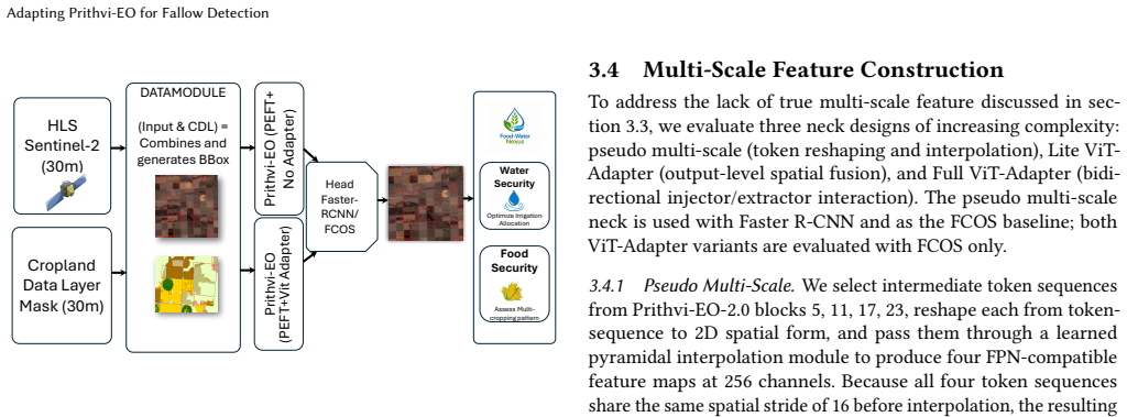
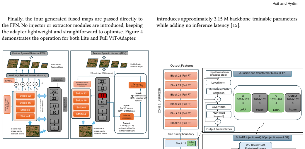
Understanding spatial distribution of fallow land is important for optimizing the food-water (FW) nexus, given fallowing's role in crop rotation and water conservation. Fallow is a low accuracy class in USDA Cropland Data Layer (CDL). Geospatial foundation model (GFM), Prithvi-EO has shown strong transferability across computer vision tasks. However, its Vision Transformer (ViT) backbone produces features at a single spatial scale that are ill-suited for the multi-scale features required by object detection heads. Existing approaches synthesise multi-scale pyramids through scaling of single stride tokens, sacrificing spatial heterogeneity, and full backbone fine-tuning is computationally prohibitive for GFMs. We evaluate a fallow detection pipeline combining two parameter-efficient fine tuning (PEFT) schemes: Low-Rank Adaptation (LoRA) and a hybrid PEFT, with three neck designs: pseudo multi-scale, Lite ViT-Adapter, and Full ViT-Adapter. Our best configuration, Lite ViT-Adapter with a one-stage head, achieves a mAP@50 of 0.9479 with the Diou loss, suggesting the effectiveness of center-aware localization for irregular fallow field detection. ViT-Adapter free one-stage detection under LoRA improves the adapter-free anchor-based approach by 6.42%, and the best configuration improves baseline adapter-free anchor-based approach by 25.70%. These results demonstrate that lightweight spatial prior fusion and selective backbone unfreezing enable Prithvi-EO to capture local fallow patterns more effectively, outperforming approaches that rely on reshaped single-stride ViT tokens.
Editorial analysis
A structured set of objections, weighed in public.
Referee Report
Summary. The manuscript evaluates parameter-efficient fine-tuning of the Prithvi-EO geospatial foundation model for fallow-land object detection. It combines LoRA with three neck designs (pseudo multi-scale, Lite ViT-Adapter, Full ViT-Adapter) and one- or two-stage heads, reporting that Lite ViT-Adapter + one-stage head + DIoU loss reaches mAP@50 = 0.9479 and yields 6.42% and 25.70% gains over stated adapter-free baselines.
Significance. If the empirical results hold under proper controls, the work supplies concrete evidence that lightweight spatial adapters plus selective backbone tuning can adapt a single-scale ViT GFM to irregular multi-scale detection without full fine-tuning or token reshaping, which is directly relevant to agricultural monitoring applications.
major comments (1)
- [Abstract] Abstract (and presumably §4 or §5): the central performance claims (mAP@50 = 0.9479, 6.42% and 25.70% relative gains) are presented without dataset size, train/val/test splits, source imagery details beyond CDL, baseline implementation specifications, number of runs, or error bars. These omissions are load-bearing for any assessment of the reported improvements.
minor comments (1)
- [Abstract] Abstract: "Diou" should be "DIoU"; "ViT-Adapter free" should be hyphenated as "ViT-Adapter-free".
Simulated Author's Rebuttal
We thank the referee for the constructive feedback on the need for fuller experimental reporting. We address the single major comment below and commit to revisions that strengthen the manuscript without altering its core claims.
read point-by-point responses
-
Referee: [Abstract] Abstract (and presumably §4 or §5): the central performance claims (mAP@50 = 0.9479, 6.42% and 25.70% relative gains) are presented without dataset size, train/val/test splits, source imagery details beyond CDL, baseline implementation specifications, number of runs, or error bars. These omissions are load-bearing for any assessment of the reported improvements.
Authors: We agree that the abstract and results sections would benefit from explicit reporting of these details to support reproducibility and evaluation of the gains. While §4 of the manuscript describes the CDL-derived dataset and imagery source, it does not currently state the exact patch count, split ratios, number of runs, or error bars. We will revise the abstract to include a concise statement of dataset scale and splits, expand §4 with a dedicated 'Experimental Setup' paragraph specifying train/val/test ratios, source imagery resolution and bands, baseline hyper-parameters, and add mean±std results over multiple runs (with error bars in tables) to §5. These additions will be made in the revised manuscript. revision: yes
Circularity Check
No significant circularity
full rationale
The paper's central claims consist of empirical performance numbers (mAP@50 = 0.9479, +6.42% and +25.70% relative gains) obtained by applying LoRA and Lite/Full ViT-Adapter necks to the Prithvi-EO backbone on a fallow-field detection task. No derivation chain, equations, or self-referential definitions appear; the reported metrics are direct experimental outcomes on a detection benchmark and do not reduce to fitted parameters or prior results by construction. The premise that single-scale ViT tokens are ill-suited for multi-scale heads is a standard observation in the ViT-adapter literature and is not required for the numerical claims to be independently verifiable or falsifiable.
Axiom & Free-Parameter Ledger
axioms (3)
- domain assumption Prithvi-EO has shown strong transferability across computer vision tasks
- domain assumption Full backbone fine-tuning is computationally prohibitive for GFMs
- domain assumption ViT backbone produces features at a single spatial scale ill-suited for multi-scale object detection
Reference graph
Works this paper leans on
-
[1]
Tamee R Albrecht, Arica Crootof, and Christopher A Scott. 2018. The Water- Energy-Food Nexus: A systematic review of methods for nexus assessment. Environmental Research Letters13, 4 (2018), 043002
2018
-
[2]
RL Anderson, RA Bowman, DC Nielsen, MF Vigil, RM Aiken, and JG Benjamin
-
[3]
Alternative crop rotations for the central Great Plains.Journal of Production Agriculture12, 1 (1999), 95–99
1999
-
[4]
Agnès Bégué, Damien Arvor, Beatriz Bellon, Julie Betbeder, Diego De Abelleyra, Rodrigo PD Ferraz, Valentine Lebourgeois, Camille Lelong, Margareth Simões, and Santiago R. Verón. 2018. Remote sensing and cropping practices: A review. Remote Sensing10, 1 (2018), 99
2018
-
[5]
Mariana Belgiu and Ovidiu Csillik. 2018. Sentinel-2 cropland mapping using pixel-based and object-based time-weighted dynamic time warping analysis. Remote sensing of environment204 (2018), 509–523
2018
-
[6]
Claire Boryan, Zhengwei Yang, Rick Mueller, and Mike Craig. 2011. Monitoring US agriculture: the US department of agriculture, national agricultural statistics service, cropland data layer program.Geocarto International26, 5 (2011), 341–358
2011
-
[7]
Qianyu Cao. 2021. Experimental study on the effect of loss function on object de- tection. InProceedings of the 2021 International Conference on Pattern Recognition and Intelligent Systems. 81–87
2021
-
[8]
Fen Chen, Haojie Zhao, Dar Roberts, Tim Van de Voorde, Okke Batelaan, Tao Fan, and Wenbo Xu. 2023. Mapping center pivot irrigation systems in global arid regions using instance segmentation and analyzing their spatial relationship with freshwater resources.Remote Sensing of Environment297 (2023), 113760
2023
- [9]
-
[10]
Gergana N Daskalova and Johannes Kamp. 2023. Abandoning land transforms biodiversity.Science380, 6645 (2023), 581–583
2023
-
[11]
Saskia Foerster, Klaus Kaden, Michael Foerster, and Sibylle Itzerott. 2012. Crop type mapping using spectral–temporal profiles and phenological information. Computers and Electronics in Agriculture89 (2012), 30–40
2012
-
[12]
Song Gao, Dalton Lunga, Lexie Yang, Shawn Newsam, and Bruno Martins. 2026. Introduction to the Special Issue on GeoAI Foundation Models and Their Appli- cations, Part I. 4 pages
2026
-
[13]
1979.Reducing drought effects on croplands in the west-central Great Plains
BW Greb. 1979.Reducing drought effects on croplands in the west-central Great Plains. Number 420. US Department of Agriculture, Science and Education Administration
1979
-
[14]
Danfeng Hong, Bing Zhang, Xuyang Li, Yuxuan Li, Chenyu Li, Jing Yao, Naoto Yokoya, Hao Li, Pedram Ghamisi, Xiuping Jia, et al. 2024. SpectralGPT: Spectral remote sensing foundation model.IEEE transactions on pattern analysis and machine intelligence46, 8 (2024), 5227–5244
2024
-
[15]
Chia-Yu Hsu, Wenwen Li, and Sizhe Wang. 2025. Geospatial foundation models for image analysis: Evaluating and enhancing NASA-IBM Prithvi’s domain adapt- ability.International Journal of Geographical Information Science39, 9 (2025), 2096–2125
2025
-
[16]
Edward J Hu, Yelong Shen, Phillip Wallis, Zeyuan Allen-Zhu, Yuanzhi Li, Shean Wang, Liang Wang, Weizhu Chen, et al. 2022. Lora: Low-rank adaptation of large language models.Iclr1, 2 (2022), 3
2022
-
[17]
Fengwei Hung, Kyongho Son, and YC Ethan Yang. 2022. Investigating uncertain- ties in human adaptation and their impacts on water scarcity in the Colorado river Basin, United States.Journal of hydrology612 (2022), 128015
2022
-
[18]
Sharad K Jain, Alok K Sikka, and Mohammad Faiz Alam. 2023. Water-energy- food-ecosystem nexus in India—A review of relevant studies, policies, and pro- grammes.Frontiers in Water5 (2023), 1128198
2023
- [19]
-
[20]
Luguang Jiang, Ye Liu, and Cheng Yang. 2024. Trade-off between the future water resource utilization and grain production in a water-deficient region from the perspective of the Water- Land- Grain nexus.Journal of Hydrology640 (2024), 131697
2024
-
[21]
Małgorzata Kozak and Rafał Pudełko. 2021. Impact assessment of the long- term fallowed land on agricultural soils and the possibility of their return to agriculture.Agriculture11, 2 (2021), 148
2021
-
[22]
Tyler J Lark, Richard M Mueller, David M Johnson, and Holly K Gibbs. 2017. Measuring land-use and land-cover change using the US department of agricul- ture’s cropland data layer: Cautions and recommendations.International journal of applied earth observation and geoinformation62 (2017), 224–235
2017
-
[23]
Tsung-Yi Lin, Piotr Dollár, Ross Girshick, Kaiming He, Bharath Hariharan, and Serge Belongie. 2017. Feature pyramid networks for object detection. InProceed- ings of the IEEE conference on computer vision and pattern recognition. 2117–2125
2017
-
[24]
Yuchi Ma, Yawen Shen, Anu Swatantran, and David B Lobell. 2026. Harvesting AlphaEarth: Benchmarking the geospatial foundation model for agricultural downstream tasks.International Journal of Applied Earth Observation and Geoin- formation149 (2026), 105258
2026
-
[25]
Francesc Marti Escofet, Benedikt Blumenstiel, Linus Scheibenreif, Paolo Fraccaro, and Konrad Schindler. 2025. Fine-tune smarter, not harder: Parameter-efficient fine-tuning for geospatial foundation models. InJoint European Conference on Machine Learning and Knowledge Discovery in Databases. Springer, 516–532
2025
-
[26]
Calvin Nguyen and Ranga Raju Vatsavai. 2025. Foundation Models for Semantic Segmentation of Thick/Thin Clouds and Cloud-shadows: A Comparative Study. InProceedings of the 33rd ACM International Conference on Advances in Geographic Information Systems. 549–552
2025
-
[27]
Adam J Oliphant, Prasad S Thenkabail, Pardhasaradhi G Teluguntla, Itiya P Aneece, Daniel J Foley, and Richard L McCormick. 2024. Automated Cropland Fallow Algorithm (ACFA) for the Northern Great Plains of USA.International Journal of Digital Earth17, 1 (2024), 2337221
2024
-
[28]
Jiangtao Peng, Yi Huang, Weiwei Sun, Na Chen, Yujie Ning, and Qian Du. 2022. Domain adaptation in remote sensing image classification: A survey.IEEE Journal of Selected Topics in Applied Earth Observations and Remote Sensing15 (2022), 9842–9859
2022
-
[29]
Shaoqing Ren, Kaiming He, Ross Girshick, and Jian Sun. 2015. Faster R-CNN: To- wards Real-Time Object Detection with Region Proposal Networks. InAdvances in Neural Information Processing Systems, Vol. 28. 91–99
2015
-
[30]
Hamid Rezatofighi, Nathan Tsoi, JunYoung Gwak, Amir Sadeghian, Ian Reid, and Silvio Savarese. 2019. Generalized intersection over union: A metric and a loss for bounding box regression. InProceedings of the IEEE/CVF conference on computer vision and pattern recognition. 658–666
2019
-
[31]
Jörg-Alfred Salamon, Janet Wissuwa, Stephan Jagos, Monika Koblmüller, Oxana Ozinger, Christine Winkler, and Thomas Frank. 2011. Plant species effects on soil macrofauna density in grassy arable fallows of different age.European Journal of Soil Biology47, 2 (2011), 129–137
2011
-
[32]
Maja Schneider, Tobias Schelte, Felix Schmitz, and Marco Körner. 2023. Euro- Crops: The largest harmonized open crop dataset across the European Union. Scientific Data10, 1 (2023), 612
2023
-
[33]
Stefan Siebert, Felix Portmann, and Petra Doell. 2010. Global Patterns of Cropland Use Intensity.Remote Sensing2 (06 2010), 1625–1643. doi:10.3390/rs2071625
-
[34]
Wen Song, Alexander V Prishchepov, and Wei Song. 2022. Mapping the spatial and temporal patterns of fallow land in mountainous regions of China.Interna- tional Journal of Digital Earth15, 1 (2022), 2148–2167
2022
-
[35]
Wen Song and Wei Song. 2023. Cropland fallow reduces agricultural water consumption by 303 million tons annually in Gansu Province, China.Science of the Total Environment879 (2023), 163013. Asif and Aydin
2023
-
[36]
Adam J Stewart, Caleb Robinson, Isaac A Corley, Anthony Ortiz, Juan M Lav- ista Ferres, and Arindam Banerjee. 2025. Torchgeo: deep learning with geospatial data.ACM Transactions on Spatial Algorithms and Systems11, 4 (2025), 1–28
2025
-
[37]
Yuba Raj Subedi, Paul Kristiansen, and Oscar Cacho. 2022. Drivers and con- sequences of agricultural land abandonment and its reutilisation pathways: A systematic review.Environmental Development42 (2022), 100681
2022
-
[38]
Daniela Szwarcman, Sujit Roy, Paolo Fraccaro, Orsteinn Eli Gislason, Benedikt Blumenstiel, Rinki Ghosal, Pedro Henrique De Oliveira, Joao Lucas de Sousa Almeida, Rocco Sedona, Yanghui Kang, Srija Chakraborty, Sizhe Wang, Car- los Gomes, Ankur Kumar, Vishal Gaur, Myscon Truong, Denys Godwin, Sam Khallaghi, Hyunho Lee, Chia Yu Hsu, Ata Akbari Asanjan, Besar...
-
[39]
Zhi Tian, Chunhua Shen, Hao Chen, and Tong He. 2019. Fcos: Fully convolutional one-stage object detection. InProceedings of the IEEE/CVF international conference on computer vision. 9627–9636
2019
-
[40]
Xiaoye Tong, Martin Brandt, Pierre Hiernaux, Stefanie Herrmann, Laura Vang Rasmussen, Kjeld Rasmussen, Feng Tian, Torbern Tagesson, Wenmin Zhang, and Rasmus Fensholt. 2020. The forgotten land use class: Mapping of fallow fields across the Sahel using Sentinel-2.Remote Sensing of Environment239 (2020), 111598
2020
-
[41]
Emily V Upcott, Peter A Henrys, John W Redhead, Susan G Jarvis, and Richard F Pywell. 2023. A new approach to characterising and predicting crop rotations using national-scale annual crop maps.Science of the Total Environment860 (2023), 160471
2023
-
[42]
Ranga Raju Vatsavai. 2024. Geospatial foundation models: Recent advances and applications. InProceedings of the 12th ACM SIGSPATIAL International Workshop on Analytics for Big Geospatial Data. 30–33
2024
-
[43]
Long Wen, Yu Cheng, Yi Fang, and Xinyu Li. 2023. A comprehensive survey of oriented object detection in remote sensing images.Expert Systems with Applications224 (2023), 119960
2023
-
[44]
Kenneth D White. 1970. Fallowing, crop rotation, and crop yields in Roman times.Agricultural History44, 3 (1970), 281–290
1970
-
[45]
Li XiaoFan, Pu HaiBo, Wei Yi, Liu JiangChuan, and Xu HongXiang. 2019. Intro- duce GIoU into RFB net to optimize object detection bounding box. InProceedings of the 5th International Conference on Communication and Information Processing. 108–113
2019
-
[46]
He Yin, Amintas Brandão Jr, Johanna Buchner, David Helmers, Benjamin G Iuliano, Niwaeli E Kimambo, Katarzyna E Lewińska, Elena Razenkova, Afag Rizayeva, Natalia Rogova, et al. 2020. Monitoring cropland abandonment with Landsat time series.Remote Sensing of Environment246 (2020), 111873
2020
-
[47]
Piotr Jarosław Żarczyński, Sławomir Józef Krzebietke, Stanisław Sienkiewicz, and Jadwiga Wierzbowska. 2023. The role of fallows in sustainable development. Agriculture13, 12 (2023), 2174
2023
-
[48]
Ketema Tilahun Zeleke. 2017. Fallow management increases soil water and nitrogen storage.Agricultural Water Management186 (2017), 12–20
2017
-
[49]
Juepeng Zheng, Zi Ye, Yibin Wen, Jianxi Huang, Zhiwei Zhang, Qingmei Li, Qiong Hu, Baodong Xu, Lingyuan Zhao, and Haohuan Fu. 2026. A comprehensive review of agricultural parcel and boundary delineation from remote sensing images: Recent progress and future perspectives.IEEE Geoscience and Remote Sensing Magazine(2026)
2026
-
[50]
Zhaohui Zheng, Ping Wang, Wei Liu, Jinze Li, Rongguang Ye, and Dongwei Ren
-
[51]
InProceedings of the AAAI conference on artificial intelligence, Vol
Distance-IoU loss: Faster and better learning for bounding box regression. InProceedings of the AAAI conference on artificial intelligence, Vol. 34. 12993– 13000
discussion (0)
Sign in with ORCID, Apple, or X to comment. Anyone can read and Pith papers without signing in.