Automated Quality Assessment of Geospatial Vector Data: A GeoAI Approach using Spatial Representation Learning
Pith reviewed 2026-06-30 09:52 UTC · model grok-4.3
The pith
Topo4Vec detects topological errors in geospatial vector data by training on simulated examples and isolating faults in a learned latent space.
A machine-rendered reading of the paper's core claim, the machinery that carries it, and where it could break.
Core claim
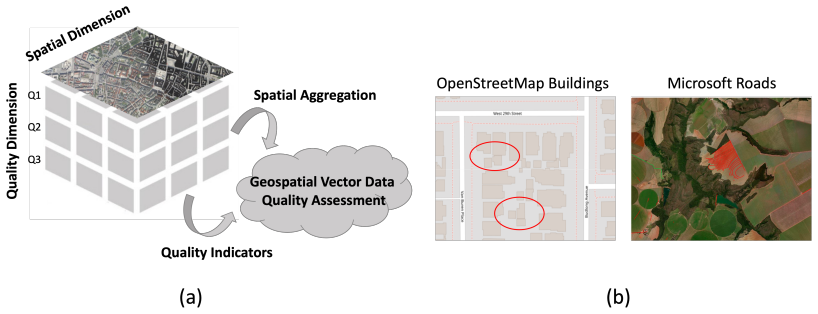
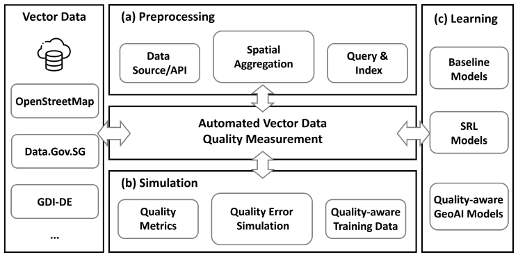
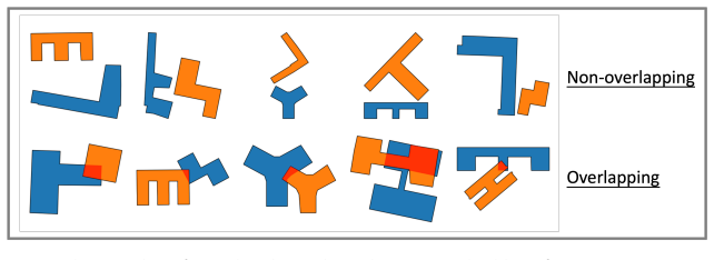
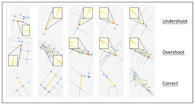
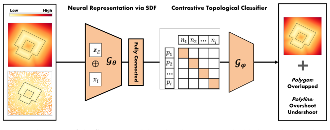
Topo4Vec relaxes manual annotation by simulating topological errors such as overlapping polygons and street network overshoots or undershoots, then encodes complex vector geometries with spatial representation learning so that errors become isolated from valid geometries in the resulting latent space.
What carries the argument
Topo4Vec framework, which pairs topological error simulation with spatial representation learning to produce a latent space separating erroneous from valid vector geometries.
If this is right
- Quality assessment of building footprints and street networks becomes feasible at city scale without per-dataset manual labeling.
- The same simulation-plus-representation pipeline can be applied to additional error types once simulation rules are defined.
- Latent-space separation provides a quantitative signal for ranking data layers by consistency across multiple cities.
- Open release of code and data allows direct replication on new vector datasets from other regions.
Where Pith is reading between the lines
- Integration into live geospatial data pipelines could flag new uploads for review before they enter public maps.
- Extending the simulation rules to three-dimensional or time-varying vector objects would test whether the latent-space isolation generalizes beyond two-dimensional footprints and networks.
Load-bearing premise
Simulated topological errors generate training examples representative enough that the learned representations can separate real errors from valid geometries.
What would settle it
Running the trained model on a fresh collection of vector data containing only unsimulated, human-verified topological errors and finding accuracy substantially below the reported 0.99 and 0.60 levels.
Figures
read the original abstract
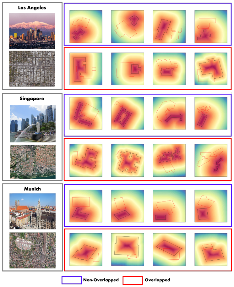
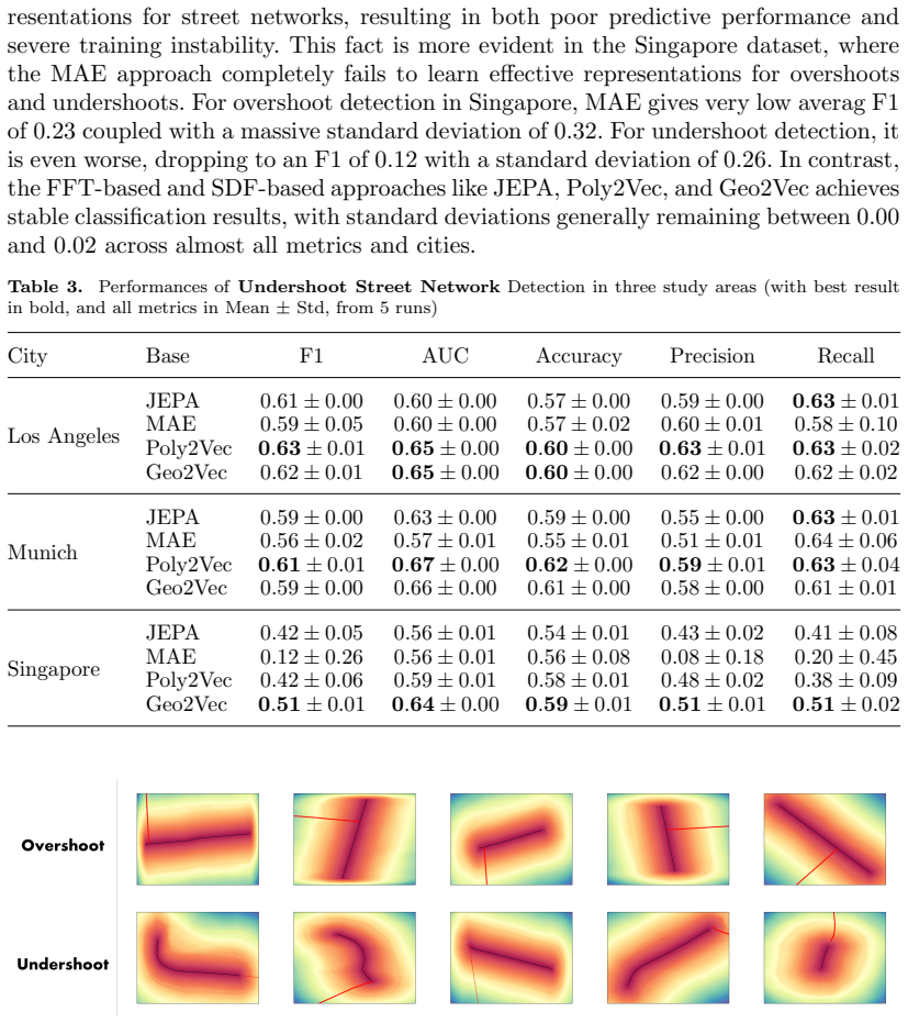
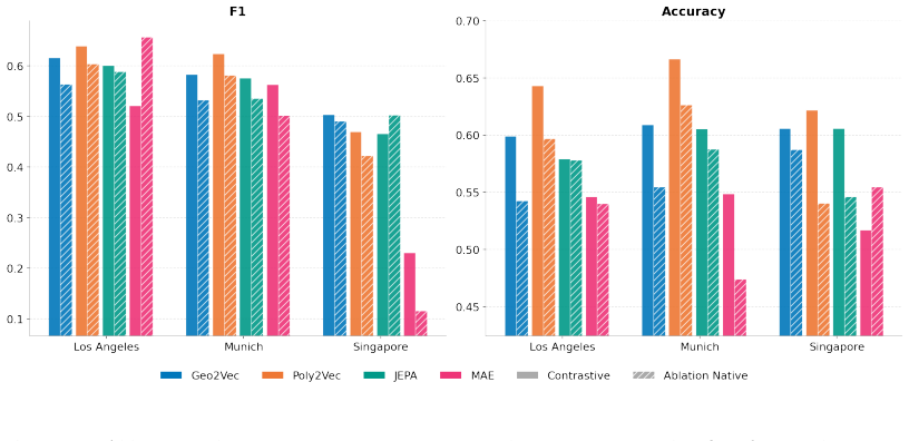
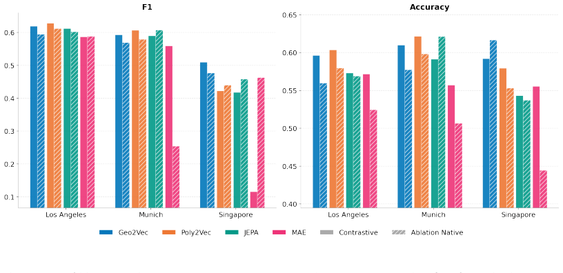
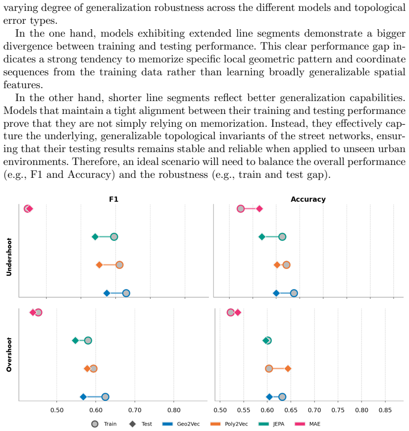
Geospatial vector data quality is a foundational research topic in GIS, yet classic rule-based quality assessment algorithms often struggle with diverse urban morphologies and massive data volumes. Recently, Geospatial Artificial Intelligence (GeoAI) shows promising potential for automating geospatial analysis, while its application to native vector data remains largely underexplored. To fill this research gap, we proposed Topo4Vec, an automated GeoAI framework, designed for scalable vector data quality assessment via advanced Spatial Representation Learning (SRL). Specifically, Topo4Vec relax the labor-intensive manual annotation process via topological error simulation, such as overlapping polygons and street network connectivity errors e.g., overshoots and undershoots. Then, it leverages state-of-the-art SRL approaches to encode complex, native vector geometries (e.g., polylines and polygons) into a latent space where topological errors are isolated from valid ones. A systematic performance evaluation across three study areas (Los Angeles, Munich, and Singapore) demonstrates the effectiveness and robustness of Topo4Vec, achieving a peak accuracy of 0.99 for detecting overlapping building footprints and 0.60 for overshoots and undershoots in street networks. Moreover, lessons learned from Topo4Vec shed a promising light into a scalable and autonomous GeoAI approach for large-scale vector data consistency and quality monitoring within the fast-growing geospatial data ecosystems. The code and data used in the paper are made openly available in https://figshare.com/s/612148eeb4bccadbd715.
Editorial analysis
A structured set of objections, weighed in public.
Referee Report
Summary. The manuscript proposes Topo4Vec, a GeoAI framework for automated quality assessment of geospatial vector data. It relaxes manual annotation by simulating topological errors (overlapping polygons; overshoots/undershoots in street networks), applies spatial representation learning (SRL) to embed native vector geometries into a latent space that isolates errors, and reports a systematic evaluation across three study areas (Los Angeles, Munich, Singapore) with peak accuracy 0.99 for building-footprint overlaps and 0.60 for network errors. Code and data are released openly.
Significance. If the simulation procedure produces error distributions statistically indistinguishable from real-world errors, the framework would supply a scalable, annotation-light method for vector-data consistency checking that extends beyond rule-based GIS tools and could support large-scale monitoring in diverse urban morphologies. The open release of code and data is a clear strength for reproducibility.
major comments (2)
- [Abstract] Abstract: the central claim that simulation enables effective SRL-based separation (and thus the reported 0.99 / 0.60 accuracies) is load-bearing, yet no quantitative comparison of geometric/topological feature distributions between simulated and authentic errors in the three study areas is supplied. Without such validation the generalization claim cannot be assessed.
- [Abstract] Abstract: the performance numbers are stated without reference to model architecture, SRL variant, baseline methods, statistical tests, or simulation-parameter settings, preventing evaluation of whether the cross-area robustness result is sound.
Simulated Author's Rebuttal
We thank the referee for the detailed and constructive feedback. We address the two major comments point by point below. Where the comments identify gaps in the current manuscript, we propose targeted revisions to strengthen the presentation of the simulation validation and result reporting.
read point-by-point responses
-
Referee: [Abstract] Abstract: the central claim that simulation enables effective SRL-based separation (and thus the reported 0.99 / 0.60 accuracies) is load-bearing, yet no quantitative comparison of geometric/topological feature distributions between simulated and authentic errors in the three study areas is supplied. Without such validation the generalization claim cannot be assessed.
Authors: We agree that a quantitative comparison of geometric and topological feature distributions between simulated and real-world errors would provide stronger support for the simulation procedure. The manuscript currently justifies the simulation by describing how it replicates documented topological error types (overlaps, overshoots, undershoots) observed in practice, and demonstrates consistent performance across three morphologically distinct cities. However, no direct statistical comparison of feature distributions (e.g., overlap ratios, intersection angles, or connectivity metrics) is included. We will add this analysis in the revised manuscript, using a sample of manually verified real errors from each study area. revision: yes
-
Referee: [Abstract] Abstract: the performance numbers are stated without reference to model architecture, SRL variant, baseline methods, statistical tests, or simulation-parameter settings, preventing evaluation of whether the cross-area robustness result is sound.
Authors: The abstract is intentionally concise. Full details on the SRL architectures (including the specific representation learning models), variants evaluated, baseline comparisons against rule-based GIS methods, statistical tests, and simulation parameter settings are provided in the Methods and Results sections. To address the concern about the abstract, we will expand it to include brief references to the primary SRL approach, the use of cross-validation, and the key simulation parameters while remaining within length limits. revision: partial
Circularity Check
No significant circularity; empirical pipeline is self-contained
full rationale
The paper generates training examples via topological error simulation (overlaps, overshoots/undershoots), applies SRL to embed geometries, and reports accuracies on three independent geographic areas. No equations, parameters, or claims reduce by construction to the simulation rules or to self-citations; the reported metrics (0.99, 0.60) are presented as outcomes of applying the learned model to external data rather than tautological re-statements of the input generation process. The derivation chain therefore contains no self-definitional, fitted-input-renamed-as-prediction, or load-bearing self-citation steps.
Axiom & Free-Parameter Ledger
free parameters (1)
- SRL model hyperparameters and simulation parameters
axioms (1)
- domain assumption Simulated topological errors sufficiently represent real-world errors to enable effective training without manual labels.
invented entities (1)
-
Topo4Vec framework
no independent evidence
Reference graph
Works this paper leans on
-
[1]
Goodchild, M. F. , title =. GeoJournal , year =
-
[2]
and Mobasheri, A
Senaratne, H. and Mobasheri, A. and Ali, A. L. and Capineri, C. and Haklay, M. , title =. International Journal of Geographical Information Science , year =
-
[3]
Rectifier nonlinearities improve neural network acoustic models , author=. Proc. icml , volume=. 2013 , organization=
2013
-
[4]
, title =
Haklay, M. , title =. Environment and planning B: Planning and design , year =
-
[5]
and Neis, P
Barron, C. and Neis, P. and Zipf, A. , title =. Transactions in GIS , year =
-
[6]
Egenhofer, M. J. and Franzosa, R. D. , title =. International Journal of Geographical Information Systems , year =
-
[7]
and Di Felice, P
Clementini, E. and Di Felice, P. and Van Oosterom, P. , title =. Advances in spatial databases , year =
-
[8]
and Zipf, A
Fan, H. and Zipf, A. and Fu, Q. and Neis, P. , title =. International Journal of Geographical Information Science , year =
-
[9]
Girres, J. F. and Touya, G. , title =. Transactions in GIS , year =
-
[10]
and Pan, S
Wu, Z. and Pan, S. and Chen, F. and Long, G. and Zhang, C. and Philip, S. Y. , title =. IEEE Transactions on Neural Networks and Learning Systems , year =
-
[11]
Proceedings of the AAAI Conference on Artificial Intelligence , volume=
Geo2vec: Shape-and distance-aware neural representation of geospatial entities , author=. Proceedings of the AAAI Conference on Artificial Intelligence , volume=
-
[12]
and Persello, C
Tuia, D. and Persello, C. and Bruzzone, L. , title =. IEEE Geoscience and Remote Sensing Magazine , year =
-
[13]
Proceedings of the 31st ACM International Conference on Advances in Geographic Information Systems , pages=
Rethink geographical generalizability with unsupervised self-attention model ensemble: A case study of openstreetmap missing building detection in africa , author=. Proceedings of the 31st ACM International Conference on Advances in Geographic Information Systems , pages=
-
[14]
Proceedings of the National Academy of Sciences , volume=
Replication across space and time must be weak in the social and environmental sciences , author=. Proceedings of the National Academy of Sciences , volume=. 2021 , publisher=
2021
-
[15]
Proceedings of the IEEE/CVF conference on computer vision and pattern recognition , pages=
Deepsdf: Learning continuous signed distance functions for shape representation , author=. Proceedings of the IEEE/CVF conference on computer vision and pattern recognition , pages=
-
[16]
International Journal of Geographical Information Science , volume=
A Voronoi-based 9-intersection model for spatial relations , author=. International Journal of Geographical Information Science , volume=. 2001 , publisher=
2001
-
[17]
Computers, Environment and Urban Systems , volume=
Global building morphology indicators , author=. Computers, Environment and Urban Systems , volume=. 2022 , publisher=
2022
-
[18]
International Journal of Applied Earth Observation and Geoinformation , volume=
A review of spatially-explicit GeoAI applications in Urban Geography , author=. International Journal of Applied Earth Observation and Geoinformation , volume=. 2022 , publisher=
2022
-
[19]
Remote Sensing of Environment , volume=
Cross-city matters: A multimodal remote sensing benchmark dataset for cross-city semantic segmentation using high-resolution domain adaptation networks , author=. Remote Sensing of Environment , volume=. 2023 , publisher=
2023
-
[20]
IEEE Transactions on Geoscience and Remote Sensing , volume=
Universal domain adaptation for remote sensing image scene classification , author=. IEEE Transactions on Geoscience and Remote Sensing , volume=. 2023 , publisher=
2023
-
[21]
ISPRS journal of photogrammetry and remote sensing , volume=
A graph convolutional neural network for classification of building patterns using spatial vector data , author=. ISPRS journal of photogrammetry and remote sensing , volume=. 2019 , publisher=
2019
-
[22]
International Journal of Geographical Information Science , pages=
A graph neural network for small-area estimation: integrating spatial regularisation, heterogeneous spatial units, and Bayesian inference , author=. International Journal of Geographical Information Science , pages=. 2025 , publisher=
2025
-
[23]
Nature Communications , volume=
A spatio-temporal analysis investigating completeness and inequalities of global urban building data in OpenStreetMap , author=. Nature Communications , volume=. 2023 , publisher=
2023
-
[24]
Transactions in GIS , volume=
Improving OpenStreetMap missing building detection using few-shot transfer learning in sub-Saharan Africa , author=. Transactions in GIS , volume=. 2022 , publisher=
2022
-
[25]
ISPRS Journal of Photogrammetry and Remote Sensing , volume=
Exploration of OpenStreetMap missing built-up areas using twitter hierarchical clustering and deep learning in Mozambique , author=. ISPRS Journal of Photogrammetry and Remote Sensing , volume=. 2020 , publisher=
2020
-
[26]
ISPRS Journal of Photogrammetry and Remote Sensing , volume=
Cross-view geolocalization and disaster mapping with street-view and VHR satellite imagery: A case study of Hurricane IAN , author=. ISPRS Journal of Photogrammetry and Remote Sensing , volume=. 2025 , publisher=
2025
-
[27]
AUTOCARTO-CONFERENCE- , pages=
A critical comparison of the 4-intersection and 9-intersection models for spatial relations: formal analysis , author=. AUTOCARTO-CONFERENCE- , pages=. 1993 , organization=
1993
-
[28]
International Journal of Digital Earth , volume=
Autonomous GIS: the next-generation AI-powered GIS , author=. International Journal of Digital Earth , volume=. 2023 , publisher=
2023
-
[29]
Big Earth Data , volume=
Deep learning for processing and analysis of remote sensing big data: A technical review , author=. Big Earth Data , volume=. 2022 , publisher=
2022
-
[30]
Journal of Spatial Information Science , number=
GeoAI: Where machine learning and big data converge in GIScience , author=. Journal of Spatial Information Science , number=
-
[31]
Annals of GIS , volume=
Giscience in the era of artificial intelligence: A research agenda towards autonomous gis , author=. Annals of GIS , volume=. 2025 , publisher=
2025
-
[32]
Proceedings of the 32nd ACM international conference on advances in geographic information systems , pages=
SRL: Towards a general-purpose framework for spatial representation learning , author=. Proceedings of the 32nd ACM international conference on advances in geographic information systems , pages=
-
[33]
Proceedings of the 3rd ACM SIGSPATIAL International Workshop on Searching and Mining Large Collections of Geospatial Data , pages=
Random Affine Transformation Feature Representation Learning for Fast Polygon Retrieval , author=. Proceedings of the 3rd ACM SIGSPATIAL International Workshop on Searching and Mining Large Collections of Geospatial Data , pages=
-
[34]
Proceedings of machine learning research , volume=
Poly2vec: Polymorphic fourier-based encoding of geospatial objects for geoai applications , author=. Proceedings of machine learning research , volume=
-
[35]
International Journal of Geographical Information Science , volume=
Estimating urban functional distributions with semantics preserved POI embedding , author=. International Journal of Geographical Information Science , volume=. 2022 , publisher=
2022
-
[36]
IEEE Transactions on Intelligent Transportation Systems , volume=
Dynamic spatial-temporal representation learning for traffic flow prediction , author=. IEEE Transactions on Intelligent Transportation Systems , volume=. 2020 , publisher=
2020
-
[37]
International Journal of Digital Earth , volume=
Recognizing mixed urban functions from human activities using representation learning methods , author=. International Journal of Digital Earth , volume=. 2023 , publisher=
2023
-
[38]
Annals of GIS , volume=
Representation learning for geospatial data , author=. Annals of GIS , volume=. 2025 , publisher=
2025
-
[39]
Proceedings of the IEEE conference on computer vision and pattern recognition , pages=
Encoding crowd interaction with deep neural network for pedestrian trajectory prediction , author=. Proceedings of the IEEE conference on computer vision and pattern recognition , pages=
-
[40]
Proceedings of the IEEE/CVF International Conference on Computer Vision Workshops , pages=
Geo-aware networks for fine-grained recognition , author=. Proceedings of the IEEE/CVF International Conference on Computer Vision Workshops , pages=
-
[41]
International Journal of Geographical Information Science , volume=
A review of location encoding for GeoAI: methods and applications , author=. International Journal of Geographical Information Science , volume=. 2022 , publisher=
2022
-
[42]
Annals of GIS , volume=
A five-year milestone: reflections on advances and limitations in GeoAI research , author=. Annals of GIS , volume=. 2024 , publisher=
2024
-
[43]
Dialogues in Human Geography , volume=
The quality of big (geo) data , author=. Dialogues in Human Geography , volume=. 2013 , publisher=
2013
-
[44]
ISPRS International Journal of Geo-Information , volume=
GeoAI for large-scale image analysis and machine vision: Recent progress of artificial intelligence in geography , author=. ISPRS International Journal of Geo-Information , volume=. 2022 , publisher=
2022
-
[45]
Journal of Spatial Information Science , number=
GeoAI for Science and the Science of GeoAI , author=. Journal of Spatial Information Science , number=. 2024 , publisher=
2024
-
[46]
ISPRS journal of photogrammetry and remote sensing , volume=
Rethinking big data: A review on the data quality and usage issues , author=. ISPRS journal of photogrammetry and remote sensing , volume=. 2016 , publisher=
2016
-
[47]
ISPRS journal of Photogrammetry and Remote Sensing , volume=
Geospatial big data handling theory and methods: A review and research challenges , author=. ISPRS journal of Photogrammetry and Remote Sensing , volume=. 2016 , publisher=
2016
-
[48]
International Journal of Geographical Information Science , volume=
Assessment of error in digital vector data using fractal geometry , author=. International Journal of Geographical Information Science , volume=. 2000 , publisher=
2000
-
[49]
GeoInformatica , volume=
Automatically conflating road vector data with orthoimagery , author=. GeoInformatica , volume=. 2006 , publisher=
2006
-
[50]
GeoInformatica , volume=
Towards general-purpose representation learning of polygonal geometries , author=. GeoInformatica , volume=. 2023 , publisher=
2023
-
[51]
International journal of geographical information science , volume=
A geographic approach for combining social media and authoritative data towards identifying useful information for disaster management , author=. International journal of geographical information science , volume=. 2015 , publisher=
2015
-
[52]
Proceedings of the 32nd ACM international conference on advances in geographic information systems , pages=
T-jepa: A joint-embedding predictive architecture for trajectory similarity computation , author=. Proceedings of the 32nd ACM international conference on advances in geographic information systems , pages=
-
[53]
Proceedings of the 30th ACM SIGKDD Conference on Knowledge Discovery and Data Mining , pages=
Controltraj: Controllable trajectory generation with topology-constrained diffusion model , author=. Proceedings of the 30th ACM SIGKDD Conference on Knowledge Discovery and Data Mining , pages=
-
[54]
Yu, Dazhou and Hu, Yuntong and Li, Yun and Zhao, Liang , title =. 2024 , isbn =. doi:10.1145/3637528.3671738 , booktitle =
-
[55]
Transactions on Machine Learning Research , issn=
Contrastive Graph Autoencoder for Shape-based Polygon Retrieval from Large Geometry Datasets , author=. Transactions on Machine Learning Research , issn=. 2024 , url=
2024
-
[56]
International Journal of Geographical Information Science , volume =
Xiongfeng Yan and Tinghua Ai and Min Yang and Xiaohua Tong , title =. International Journal of Geographical Information Science , volume =. 2021 , publisher =. doi:10.1080/13658816.2020.1768260 , URL =
-
[57]
RSS 2016 workshop: geometry and beyond-representations, physics, and scene understanding for robotics , year=
Signed distance fields: A natural representation for both mapping and planning , author=. RSS 2016 workshop: geometry and beyond-representations, physics, and scene understanding for robotics , year=
2016
-
[58]
IEEE Access , volume=
OpenStreetMap data quality assessment via deep learning and remote sensing imagery , author=. IEEE Access , volume=. 2019 , publisher=
2019
-
[59]
International Journal of Digital Earth , volume=
Assessing OSM building completeness for almost 13,000 cities globally , author=. International Journal of Digital Earth , volume=. 2022 , publisher=
2022
-
[60]
Transactions in GIS , volume=
Towards an open source analysis toolbox for street network comparison: Indicators, tools and results of a comparison of OSM and the official A ustrian reference graph , author=. Transactions in GIS , volume=. 2014 , publisher=
2014
-
[61]
Transactions in GIS , volume=
Towards an automated comparison of OpenStreetMap with authoritative road datasets , author=. Transactions in GIS , volume=. 2017 , publisher=
2017
-
[62]
Building and Environment , volume=
Quality of crowdsourced geospatial building information: A global assessment of OpenStreetMap attributes , author=. Building and Environment , volume=. 2023 , publisher=
2023
-
[63]
Transactions in GIS , volume=
Regional variations of context-based association rules in OpenStreetMap , author=. Transactions in GIS , volume=. 2021 , publisher=
2021
-
[64]
OpenStreetMap in GIScience: experiences, research, and applications , pages=
Quality assessment of the contributed land use information from OpenStreetMap versus authoritative datasets , author=. OpenStreetMap in GIScience: experiences, research, and applications , pages=. 2015 , publisher=
2015
-
[65]
Computers, Environment and Urban Systems , volume=
Building footprint data for countries in Africa: to what extent are existing data products comparable? , author=. Computers, Environment and Urban Systems , volume=. 2024 , publisher=
2024
discussion (0)
Sign in with ORCID, Apple, or X to comment. Anyone can read and Pith papers without signing in.