REVIEW 4 major objections 5 minor 51 references
Cleaning noisy parcel labels, not scaling models, doubles global field-boundary mapping accuracy.
Reviewed by Pith at T0; open to challenge. T0 means a machine referee read the full paper against a public rubric. the ladder, T0–T4 →
T0 review · deepseek-v4-flash
2026-08-01 13:31 UTC pith:MKLXNQD5
load-bearing objection A serious data-cleaning effort around a stock YOLOv11, with a valuable dataset release and a big claimed gain that currently rests only on a self-made benchmark. the 4 major comments →
Delineate Anything v2: A Global Foundation Model for Field Delineation
The pith
A machine-rendered reading of the paper's core claim, the machinery that carries it, and where it could break.
Core claim
The paper's central claim is that a resolution-aware data curation pipeline, applied to a large but noisy multi-national field-boundary repository, yields a foundation model whose zero-shot generalization is roughly double that of the prior state of the art. The discovery is not a new architecture — the model uses a standard instance-segmentation backbone — but a demonstration that structural label noise (administrative parcels containing several physical fields) is the dominant bottleneck. For high-resolution imagery the fix is manual geometric splitting; for medium-resolution imagery, where manual correction is too costly, the fix is topological image-space adaptation: flagging parcels wit
What carries the argument
FBIS-73M, a 73-million-instance, multi-resolution (0.25–10 m) field-boundary training set spanning 61 countries, plus a two-stage curation pipeline. Automated screening flags parcels with abnormal intra-mask spectral deviation. Flagged high-resolution parcels are manually re-drawn; flagged medium-resolution parcels are repaired in image space: a cyclical bounding transformation (Eq. 1) homogenizes pixel color around the parcel's mode to erase false internal edges, and a Khalimsky-grid edge enhancement step strengthens genuine but visually weak boundaries via soft-light blending. The curated set is trained on 512×512 patches with a standard real-time instance-segmentation backbone, and evalua
Load-bearing premise
The reported doubling of accuracy rests on a benchmark the authors created themselves — exactly four manually selected 'representative' patches per country, with no documented check that these 100 countries are disjoint from the 61 countries in the training set or that the patches were not chosen with the model's strengths in mind.
What would settle it
Run the released model on an independently annotated, pre-registered held-out benchmark (for example, a third-party global field-boundary test set) and compare mAP@0.5. If the roughly 2× gain over the prior state of the art does not reproduce, or if withholding the homogenization and edge-enhancement edits from a random subset of training patches changes accuracy substantially, then either the benchmark or the curation effect is overstated. The single most decisive observation would be a per-country scatter plot of benchmark score versus whether that country appears in the 61-country training
If this is right
- National- and global-scale field maps can be produced at speeds compatible with operational monitoring: the model maps 603,000 km² of Ukraine in 5.4 hours on a consumer workstation, or about 112,000 km² per hour.
- Scaling data without fixing structural label noise hits a ceiling; the ablation shows raw scaling from 22M to 73M instances adds only +0.086 mAP, while curation adds +0.198, so future dataset efforts should prioritize quality control over volume.
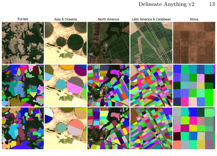
- Zero-shot transfer to under-represented regions is where the gain is largest: Africa's regional score roughly doubles from 0.251 to 0.584 and Asia & Oceania nearly triples from 0.161 to 0.440, supporting the claim that geographic diversity plus consistent supervision enables planetary generalization.
- Because the curation pipeline is architecture-agnostic and the data, weights, code, and vector products are publicly released, other geospatial delineation tasks can adopt the same remediation recipe without changing their underlying model.
Where Pith is reading between the lines
- The image-space homogenization and edge-enhancement steps intentionally change the pixel statistics of training patches, so the model may learn to expect a 'cleaned' texture. A testable consequence is that performance on raw, unedited satellite imagery from novel regions could be lower than on the curated benchmark — a distribution gap the paper does not analyze.
- The same parcel-versus-field mismatch afflicts other geospatial vector layers such as building footprints and land parcels, so the screening-and-remediation recipe could transfer; a natural next experiment is applying it to those domains.
- Because the benchmark is four hand-picked patches per country with equal country weighting, the reported mAP measures cross-country landscape diversity rather than within-country reliability; per-region and per-season variance is likely larger than a four-patch sample can capture.
- An independent, pre-registered held-out annotation campaign in countries not represented in the training corpus would settle whether the +103% gain is a property of the method or of the evaluation design, and would control for any overlap between the 100 benchmark countries and the 61 training countries.
Editorial analysis
A structured set of objections, weighed in public.
Referee Report
Summary. The paper introduces Delineate Anything v2, a field-boundary delineation foundation model built on a data-centric paradigm rather than architectural innovation. The authors construct FBIS-73M, a 73-million-instance, 61-country multi-resolution training dataset, and propose a resolution-specific curation pipeline that (a) manually splits high-resolution merged parcels and (b) applies image-space pixel homogenization and Khalimsky-grid edge enhancement to medium-resolution imagery. They also manually curate a 100-country evaluation benchmark (4 patches per country) and report that Delineate Anything v2 surpasses Delineate Anything v1 by 0.284 mAP@0.5 (+103.3% relative gain) on this benchmark, with ablations attributing the bulk of the gain (+0.198) to data curation rather than dataset scaling (+0.086). The paper additionally demonstrates nationwide mapping of Ukraine at 5.4 hours on consumer hardware and releases code, weights, dataset, and vector products.
Significance. If the central claims hold, the paper makes a notable empirical contribution: it is the largest public field-boundary training repository, it releases a geographically diverse benchmark, and its ablation provides evidence that supervision quality, not model architecture or raw data volume, is the binding constraint in global field delineation. The release of code, weights, and vector products is a concrete strength that could support reproducible research. The central SOTA claim, however, rests entirely on a self-created, 400-patch benchmark whose independence from the training countries is not demonstrated and whose patch-selection protocol is not reported. The paper also declines quantitative comparison against public external checkpoints, weakening the falsifiability of the SOTA itself. These concerns are load-bearing, but they are addressable within the manuscript's scope.
major comments (4)
- [§3.1, §4.2, Table 1] The headline claim of +0.284 mAP@0.5 (+103.3% relative) is measured exclusively on a benchmark the authors constructed: exactly four manually selected 512×512 patches per country. The manuscript calls the benchmark 'independent' and §5 says it evaluates 'outside the training distribution,' but it never states whether the 100 benchmark countries are disjoint from the 61 FBIS-73M training countries, nor does it describe the patch-selection protocol, annotator instructions, or quality-control procedure. If benchmark countries overlap training countries, or if 'representative' patches were chosen in a way that favors the curation pipeline, the zero-shot SOTA claim is an evaluation artifact. Please report an explicit country-overlap analysis, a step-by-step patch-selection protocol, inter-annotator agreement, and multi-seed error bars (or bootstrap confidence intervals) for Table 1. The Europ
- [§4.4] The paper states that direct metric benchmarking against FTW, PRUE, NASA Harvest, and Sinergise is 'unfeasible without public weights [1,40]' and therefore provides only visual comparison. This is contradicted by the public availability of FTW and PRUE weights; NASA Harvest static layers are also described as publicly available in the same sentence. As written, the SOTA claim is non-falsifiable because no external baseline is scored on the same benchmark. Please provide quantitative mAP (or an equivalent, explicitly defined metric) for FTW, PRUE, and NASA Harvest on the 100-country benchmark, or justify in detail why such scoring is infeasible despite the released weights.
- [§3.3, §3.4, Eq. (1)] The central mechanism of the paper modifies training images rather than labels: pixel homogenization folds large color deviations into a bounded range using a sensor-specific B (Eq. 1), and Khalimsky-grid edge enhancement darkens/lightens pixels around weak boundaries with a soft-light blend of strength α. A model trained on such edited imagery may learn to rely on edit fingerprints (e.g., the triangular-wave quantization pattern or the synthetic contrast edge) that are absent in real, unedited test imagery. The paper provides no analysis of this distribution gap. Please run an inference-only experiment on unedited validation patches (i.e., raw imagery withheld from the pipeline) or an ablation that disables edge enhancement at inference time to confirm that the reported zero-shot gains are not an artifact of train-time image editing.
- [§4.3, Table 3] The ablation table is internally consistent, but the gain attributions are presented in a way that can mislead. The text says data curation contributes an additional +0.198 mAP over raw scaling (0.559 − 0.361), which is correct. However, Table 3 labels the 'Full Curation Pipeline' row as '+0.150', which is the incremental gain over the HR-manual-split row (0.409), not the cumulative curation gain. Please relabel the Gain column as incremental or add a separate cumulative-gain column to avoid conflation of the curation contribution with the final increment.
minor comments (5)
- [§4.1] Metric notation is inconsistent: 'mAP@0.5:0.95' and 'mAP@[0.5:0.95]' are both used. Please unify.
- [§3.2, §3.3, §3.4] Several thresholds are described as 'empirically set' or 'selected conservatively' with no sensitivity analysis: the 15%/10%/5% area-flag thresholds, B=32/48, the mid-range threshold of 64, and the edge-strength and weak-fraction thresholds. Given that the paper's thesis is that curation drives gains, a brief sensitivity study (or at least a statement that results are stable over a range of thresholds) would substantially strengthen the claim.
- [Fig. 7 caption] The caption cites 'DelAny [21]' for a static layer, but [21] is the ECAI paper; it would be clearer to cite the specific released checkpoint/static product (e.g., the v1 model repository) rather than the paper.
- [§4.2] The sentence 'performance doubles in Africa (+0.333) and nearly triples in Asia & Oceania (+0.279)' is ambiguous: the +0.333 and +0.279 are absolute mAP increases, not relative multiples. Please state both absolute and relative gains explicitly.
- [Abstract/§1] Minor wording: 'Delineate Anything v2 surpasses the current state-of-the-art, including the Delineate Anything framework' is circular because the prior state of the art is the authors' own model. Rephrasing as 'previous state of the art' would be more neutral.
Circularity Check
No circular derivation found: the headline gain is an empirical measurement on a self-created benchmark, with self-citation baseline but no equation-level reduction to inputs.
full rationale
The central claim (abstract; §4.2) — that Delineate Anything v2 surpasses Delineate Anything by 0.284 mAP@0.5 (+103.3% relative) — is a measured difference on the authors' own 100-country benchmark, not a quantity derived by construction from the curation equations. No equation in §3.3–3.4 is shown to equal the reported metric; Eq. (1) is a data transformation with empirically set B, and the 15/10/5% flags are described as 'selected conservatively' and 'kept fixed across all datasets,' with no statement that they were tuned on the benchmark. Without such a statement, the possibility of benchmark tuning is speculation, not a demonstrable reduction, so the 'fitted input called prediction' pattern is not established. The baseline is the authors' own Delineate Anything [21] and the benchmark is self-created, which weakens external validity, but the comparison is empirical rather than imported by citation; this is a self-citation that is not load-bearing in the derivation. The paper's own limitation in §4.4 ('direct metric benchmarking against baseline frameworks and open mapping pipelines is unfeasible without public weights') and the missing explicit statement in §3.1 that the 100 benchmark countries are disjoint from the 61 training countries are evaluation-validity concerns, not circularity: they affect whether the SOTA claim is falsifiable and independent, but they do not make the result equal to its inputs. The ablation (Table 3) is internally consistent and each increment is measured on the same benchmark, so the conclusion that curation drives the gain is an empirical claim, not a definitional one. Thus no significant circularity; score 2 reflects only the minor self-citation baseline and self-created evaluation, which are treated as non-circular weaknesses.
Axiom & Free-Parameter Ledger
free parameters (7)
- Gaussian blur kernel size 13x13 =
13x13
- Deviation threshold sets for screening =
[10,20,50]% Sentinel-2; [25,35,50]% Planet
- Multi-field flagging area thresholds =
15% / 10% / 5% of parcel area
- Sensor-specific bounding range B =
B=32 (Sentinel-2), B=48 (Planet)
- Mid-range threshold and soft-light strength alpha =
64 (8-bit); alpha in [0,1]
- Edge-strength and weak-fraction thresholds =
not reported numerically
- AdamW learning rate =
1e-7
axioms (5)
- domain assumption Multi-field administrative parcels are detectable by intra-mask spectral deviation (flagged when cumulative deviation-area exceeds 15/10/5% of the parcel).
- domain assumption Editing the training image (pixel homogenization + synthetic edge darkening) yields samples drawn from the same distribution the model will see at inference.
- standard math Khalimsky-grid digital-topology properties (odd-odd pixels, odd-even/even-odd edges, even-even junctions) as in Khalimsky et al. [15].
- domain assumption COCO-pretrained YOLOv11 weights are a suitable initialization for satellite field delineation.
- domain assumption The manually annotated 100-country benchmark is accurate, its four patches per country are representative, and its countries are (implicitly) not used for training.
read the original abstract
Accurate agricultural field boundary delineation at large scale is a foundational task for food security, supply chain transparency, and carbon accounting. While vision foundation models like SAM show remarkable zero-shot capabilities, they frequently fail in geospatial domains due to topological complexity, cropland texturing patterns, and a lack of physical scale awareness. In this work, we introduce Delineate Anything v2, a globally scalable foundation model designed specifically for wide-area field boundary mapping. We construct FBIS-73M, a 73-million-instance multi-resolution dataset spanning 61 countries. To address the pervasive issue of multi-field administrative parcel merging, we introduce a resolution-specific data curation pipeline that leverages topological image-space adaptation to homogenize merged parcels and strengthen weak physical boundaries. Furthermore, we establish a novel, manually curated evaluation benchmark covering 100 countries to assess independent zero-shot generalization. Our results show that Delineate Anything v2 surpasses the current state-of-the-art, including the Delineate Anything framework, by 0.284 mAP@0.5 (+103.3% relative gain), while maintaining execution speeds suitable for rapid national- and global-scale deployment, as demonstrated by nationwide mapping of Ukraine (603,000 km^2) in 5.4 hours on a consumer-grade workstation. Code, pre-trained weights, the FBIS-73M dataset, and ready-to-use national-scale vector boundary products are publicly available at https://github.com/Lavreniuk/Delineate-Anything.
Figures



Reference graph
Works this paper leans on
-
[1]
Batič, M., Peressutti, D., Vesel, N., Verbič, S., Lubej, M., Oman Kadunc, N.: EU field boundaries (2024).https://doi.org/10.5281/zenodo.14229033,https: //doi.org/10.5281/zenodo.14229033
-
[2]
IEEE Transactions on Geo- science and Remote Sensing60(2022).https://doi.org/10.1109/TGRS.2022
Burgert, T., Ravanbakhsh, M., Demir, B.: On the effects of different types of label noise in multi-label remote sensing image classification. IEEE Transactions on Geo- science and Remote Sensing60(2022).https://doi.org/10.1109/TGRS.2022. 3226371
-
[3]
Carion, N., Gustafson, L., Hu, Y.T., Debnath, S., Hu, R., Suris, D., Ryali, C., Alwala, K.V., Khedr, H., Huang, A., Lei, J., Ma, T., Guo, B., Kalla, A., Marks, M., Greer, J., Wang, M., Sun, P., Rädle, R., Afouras, T., Mavroudi, E., Xu, K., Wu, T.H., Zhou, Y., Momeni, L., Hazra, R., Ding, S., Vaze, S., Porcher, F., Li, F., Li, S., Kamath, A., Cheng, H.K., ...
Pith/arXiv arXiv 2026
-
[4]
IEEE Transactions on Geoscience and Remote Sensing62, 1–17 (2024)
Chen, K., Liu, C., Chen, H., Zhang, H., Li, W., Zou, Z., Shi, Z.: Rsprompter: Learn- ing to prompt for remote sensing instance segmentation based on visual foundation model. IEEE Transactions on Geoscience and Remote Sensing62, 1–17 (2024). https://doi.org/10.1109/TGRS.2024.3356074
arXiv 2024
-
[5]
11th International Conference on Learning Representations, ICLR 2023 (5 2022)
Chen, Z., Duan, Y., Wang, W., He, J., Lu, T., Dai, J., Qiao, Y.: Vision trans- former adapter for dense predictions. 11th International Conference on Learning Representations, ICLR 2023 (5 2022)
2023
-
[6]
D’andrimont, R., Claverie, M., Kempeneers, P., Muraro, D., Yordanov, M., Peres- sutti, D., Batič, M., Waldner, F.: Ai4boundaries: an open ai-ready dataset to map fieldboundarieswithsentinel-2andaerialphotography.EarthSystemScienceData 15, 317–329 (1 2023).https://doi.org/10.5194/ESSD-15-317-2023,
-
[7]
Diakogiannis, F.I., Waldner, F., Caccetta, P., Wu, C.: Resunet-a: A deep learning framework for semantic segmentation of remotely sensed data. ISPRS Journal of Photogrammetry and Remote Sensing162, 94–114 (4 2020).https://doi.org/ 10.1016/J.ISPRSJPRS.2020.01.013
-
[8]
IEEE Geoscience and Remote Sensing Letters21(2024).https://doi
Feng, W., Guan, F., Sun, C., Xu, W.: Road-sam: Adapting the segment anything model to road extraction from large very-high-resolution optical remote sensing images. IEEE Geoscience and Remote Sensing Letters21(2024).https://doi. org/10.1109/LGRS.2024.3430900
arXiv 2024
-
[9]
Remote Sensing 2024, Vol
Hell, M., Brandmeier, M.: Identifying plausible labels from noisy training data for a land use and land cover classification application in amazônia legal. Remote Sensing 2024, Vol. 16, Page 208016, 2080 (6 2024).https://doi.org/10.3390/ RS16122080
2024
-
[10]
Highfll, N.S.S.K.H., Aroyo, D.A.P.P.L., Sambasivan, N., Kapania, S., Highfll, H., Akrong, D., Paritosh, P., Aroyo, L.: Everyone wants to do the model work, not the data work: Data cascades in high-stakes ai. Conference on Human Factors in Computing Systems - Proceedings (5 2021).https://doi.org/10.1145/3411764. 3445518
doi:10.1145/3411764 2021
-
[11]
Remote Sensing 2024, Vol
Huang, Z., Jing, H., Liu, Y., Yang, X., Wang, Z., Liu, X., Gao, K., Luo, H.: Segment anything model combined with multi-scale segmentation for extracting complex cultivated land parcels in high-resolution remote sensing images. Remote Sensing 2024, Vol. 16, Page 348916, 3489 (9 2024).https://doi.org/10.3390/ RS16183489 16 M. Lavreniuk et al
2024
-
[12]
Jocher, G., Qiu, J., Liu, M., Lyu, S., Akyon, F.C., Kalfaoglu, M.E.: Ultralytics yolo26: Unified real-time end-to-end vision models (2026),https://arxiv.org/ abs/2606.03748
Pith/arXiv arXiv 2026
-
[13]
Kerner, H., Chaudhari, S., Ghosh, A., Robinson, C., Ahmad, A., Choi, E., Jacobs, N., Holmes, C., Mohr, M., Dodhia, R., Ferres, J.M.L., Marcus, J.: Fields of the world:Amachinelearningbenchmarkdatasetforglobalagriculturalfieldboundary segmentation. Proceedings of the AAAI Conference on Artificial Intelligence39, 28151–28159 (9 2024).https://doi.org/10.1609...
-
[14]
In: Proceedings of the AAAI Conference on Artificial Intelligence
Kerner, H., Chaudhari, S., Ghosh, A., Robinson, C., Ahmad, A., Choi, E., Jacobs, N., Holmes, C., Mohr, M., Dodhia, R., et al.: Fields of the world: A machine learning benchmark dataset for global agricultural field boundary segmentation. In: Proceedings of the AAAI Conference on Artificial Intelligence. vol. 39, pp. 28151–28159 (2025)
2025
-
[15]
Topology and its Applications36, 1–17 (7 1990)
Khalimsky, E., Kopperman, R., Meyer, P.R.: Computer graphics and connected topologies on finite ordered sets. Topology and its Applications36, 1–17 (7 1990). https://doi.org/10.1016/0166-8641(90)90031-V
-
[16]
arXiv preprint arXiv:2410.17725 (10 2024)
Khanam, R., Hussain, M.: Yolov11: An overview of the key architectural enhance- ments. arXiv preprint arXiv:2410.17725 (10 2024)
Pith/arXiv arXiv 2024
-
[17]
Proceedings of the IEEE International Conference on Computer Vision pp
Kirillov, A., Mintun, E., Ravi, N., Mao, H., Rolland, C., Gustafson, L., Xiao, T., Whitehead, S., Berg, A.C., Lo, W.Y., Dollár, P., Girshick, R.: Segment anything. Proceedings of the IEEE International Conference on Computer Vision pp. 3992– 4003 (4 2023).https://doi.org/10.1109/ICCV51070.2023.00371
arXiv 2023
-
[18]
IEEE Geoscience and Remote Sensing Letters14, 778–782 (5 2017).https://doi.org/10.1109/LGRS
Kussul, N., Lavreniuk, M., Skakun, S., Shelestov, A.: Deep learning classification of land cover and crop types using remote sensing data. IEEE Geoscience and Remote Sensing Letters14, 778–782 (5 2017).https://doi.org/10.1109/LGRS. 2017.2681128
arXiv 2017
-
[19]
Kussul, N., Lemoine, G., Gallego, F.J., Skakun, S.V., Lavreniuk, M., Shelestov, A.Y.: Parcel-based crop classification in ukraine using landsat-8 data and sentinel- 1a data. IEEE Journal of Selected Topics in Applied Earth Observations and Re- mote Sensing9, 2500–2508 (6 2016).https://doi.org/10.1109/JSTARS.2016. 2560141
-
[20]
In: European Conference on Computer Vision Workshops (ECCVW)
Lavreniuk, M., Bhat, S.F., Muller, M., Wonka, P.: Evp: Enhanced visual percep- tion using inverse multi-attentive feature refinement and regularized image-text alignment. In: European Conference on Computer Vision Workshops (ECCVW). pp. 206–225 (2024)
2024
-
[21]
In: European Conference on Artificial Intelligence (4 2025)
Lavreniuk, M., Kussul, N., Shelestov, A., Yailymov, B., Salii, Y., Kuzin, V., Szantoi, Z.: Delineate anything: Resolution-agnostic field boundary delineation on satellite imagery. In: European Conference on Artificial Intelligence (4 2025). https://doi.org/10.48550/arXiv.2504.02534
-
[22]
Lei, M., Li, S., Wu, Y., Hu, H., Zhou, Y., Zheng, X., Ding, G., Du, S., Wu, Z., Gao, Y.: Yolov13: Real-time object detection with hypergraph-enhanced adaptive visual perception (2025),https://arxiv.org/abs/2506.17733
Pith/arXiv arXiv 2025
-
[23]
Li, M., Long, J., Stein, A., Wang, X.: Using a semantic edge-aware multi-task neural network to delineate agricultural parcels from remote sensing images. ISPRS Journal of Photogrammetry and Remote Sensing200, 24–40 (6 2023).https: //doi.org/10.1016/J.ISPRSJPRS.2023.04.019
-
[24]
Lin, T.Y., Maire, M., Belongie, S., Hays, J., Perona, P., Ramanan, D., Dollár, P., Zitnick, C.L.: Microsoft coco: Common objects in context. Lecture Notes in Computer Science (including subseries Lecture Notes in Artificial Intelligence and Lecture Notes in Bioinformatics)8693 LNCS, 740–755 (5 2014).https://doi. org/10.1007/978-3-319-10602-1_48 Delineate ...
-
[25]
Liu, C., Albrecht, C.M., Wang, Y., Li, Q., Zhu, X.X.: Aio2: Online correction of object labels for deep learning with incomplete annotation in remote sensing image segmentation. IEEE Transactions on Geoscience and Remote Sensing62, 1–17 (2024).https://doi.org/10.1109/TGRS.2024.3373908
arXiv 2024
-
[26]
Liu, Y., Zhong, Y., Ma, A., Zhao, J., Zhang, L.: Cross-resolution national-scale land-cover mapping based on noisy label learning: A case study of china. Interna- tional Journal of Applied Earth Observation and Geoinformation118, 103265 (4 2023).https://doi.org/10.1016/J.JAG.2023.103265
arXiv 2023
-
[27]
Long, J., Li, M., Wang, X.: Boundary-aware multi-task neural networks for agri- cultural field extraction from very high-resolution satellite images. International Conference on Geoinformatics2022-August(2022).https://doi.org/10.1109/ GEOINFORMATICS57846.2022.9963838
arXiv 2022
-
[28]
IEEE Geoscience and Remote Sensing Letters 21(2024).https://doi.org/10.1109/LGRS.2024.3454263
Long, J., Zhao, H., Li, M., Wang, X., Lu, C.: Integrating segment anything model derived boundary prior and high-level semantics for cropland extraction from high- resolution remote sensing images. IEEE Geoscience and Remote Sensing Letters 21(2024).https://doi.org/10.1109/LGRS.2024.3454263
arXiv 2024
-
[29]
IEEE Transactions on Geoscience and Remote Sensing62(2024).https://doi.org/10.1109/TGRS
Luo, M., Zhang, T., Wei, S., Ji, S.: Sam-rsis: Progressively adapting sam with box prompting to remote sensing image instance segmentation. IEEE Transactions on Geoscience and Remote Sensing62(2024).https://doi.org/10.1109/TGRS. 2024.3460085
arXiv 2024
-
[30]
arXiv preprint arXiv:2603.27101 (2026)
Muhawenayo, G., Robinson, C., Khanal, S., Fang, Z., Corley, I., Wollam, A., Gao, T.,Strnad,L.,Avery,R.,Estes,L.,etal.:Prue:Apracticalrecipeforfieldboundary segmentation at scale. arXiv preprint arXiv:2603.27101 (2026)
arXiv 2026
-
[31]
Ng, A.: Data-centric ai (2021),https://datacentricai.org/, accessed: 2026-06- 23
2021
-
[32]
Osco, L.P., Wu, Q., de Lemos, E.L., Gonçalves, W.N., Ramos, A.P.M., Li, J., Marcato, J.: The segment anything model (sam) for remote sensing applications: From zero to one shot. International Journal of Applied Earth Observation and Geoinformation124(11 2023).https://doi.org/10.1016/j.jag.2023.103540
arXiv 2023
-
[33]
Pan, C., Fan, X., Tjahjadi, T., Guan, H., Fu, L., Ye, Q., Wang, R.: Vision founda- tion model guided multimodal fusion network for remote sensing semantic segmen- tation.IEEEJournalofSelectedTopicsinAppliedEarthObservationsandRemote Sensing18, 9409–9431 (2025).https://doi.org/10.1109/JSTARS.2025.3547880
arXiv 2025
-
[34]
Pan,Y.,Wang,X.,Wang,Y.,Zhong,Y.:Rbp-mtl:Agriculturalparcelvectorization via region-boundary-parcel decoupled multitask learning. IEEE Transactions on Geoscience and Remote Sensing62, 1–15 (2024).https://doi.org/10.1109/ TGRS.2024.3367850
arXiv 2024
-
[35]
Pan, Y., Wang, X., Zhang, L., Zhong, Y.: E2evap: End-to-end vectorization of smallholder agricultural parcel boundaries from high-resolution remote sensing im- agery. ISPRS Journal of Photogrammetry and Remote Sensing203, 246–264 (9 2023).https://doi.org/10.1016/J.ISPRSJPRS.2023.08.001
-
[36]
Pelletier, C., Valero, S., Inglada, J., Champion, N., Sicre, C.M., Dedieu, G.: Effect of training class label noise on classification performances for land cover mapping with satellite image time series. Remote Sensing 2017, Vol. 9, Page 1739, 173 (2 2017).https://doi.org/10.3390/RS9020173
-
[37]
Persello, C., Member, S., Grift, J., Fan, X., Paris, C., Hänsch, R., Koeva, M., Nelson, A.: Ai4smallfarms: A dataset for crop field delineation in southeast asian smallholder farms. IEEE GEOSCIENCE AND REMOTE SENSING LETTERS 20, 2023 (2023).https://doi.org/10.17026/dans-xy6-ngg6 18 M. Lavreniuk et al
-
[38]
13th International Conference on Learning Representations, ICLR 2025 pp
Ravi, N., Gabeur, V., Hu, Y.T., Hu, R., Ryali, C., Ma, T., Khedr, H., Rädle, R., Rolland, C., Gustafson, L., Mintun, E., Pan, J., Alwala, K.V., Carion, N., Wu, C.Y., Girshick, R., Dollár, P., Feichtenhofer, C.: Sam 2: Segment anything in images and videos. 13th International Conference on Learning Representations, ICLR 2025 pp. 41175–41218 (8 2024),https:...
Pith/arXiv arXiv 2025
-
[39]
8340–8350 (4 2023).https: //doi.org/10.1109/WACV57701.2024.00817
Ren, S., Luzi, F., Lahrichi, S., Kassaw, K., Collins, L.M., Bradbury, K., Malof, J.M.: Segment anything, from space? Proceedings - 2024 IEEE Winter Conference on Applications of Computer Vision, WACV 2024 pp. 8340–8350 (4 2023).https: //doi.org/10.1109/WACV57701.2024.00817
arXiv 2024
-
[40]
Scientific Data12(12 2025).https: //doi.org/10.1038/S41597-025-05190-7,
Sadeh, Y., Wagner, J., Nair, S.S., Oliinyk, O., Belles, E., Bibih, A., D’Harboullé, L., Bendahmane, H., Gupta, M., Becker-Reshef, I.: National-scale in-season field boundaries of ukraine using remote sensing. Scientific Data12(12 2025).https: //doi.org/10.1038/S41597-025-05190-7,
-
[41]
One Earth3, 237–250 (8 2020).https://doi.org/10.1016/j.oneear.2020.07.011
Scown, M.W., Brady, M.V., Nicholas, K.A.: Billions in misspent eu agricultural subsidies could support the sustainable development goals. One Earth3, 237–250 (8 2020).https://doi.org/10.1016/j.oneear.2020.07.011
-
[42]
Frontiers in Earth Science5, 1–10 (2 2017)
Shelestov, A., Lavreniuk, M., Kussul, N., Novikov, A., Skakun, S.: Exploring google earth engine platform for big data processing: Classification of multi-temporal satellite imagery for crop mapping. Frontiers in Earth Science5, 1–10 (2 2017). https://doi.org/10.3389/FEART.2017.00017/TEXT
arXiv 2017
-
[43]
Sun, J., Yan, S., Yao, X., Gao, B., Yang, J.: A segment anything model based weakly supervised learning method for crop mapping using sentinel-2 time series images. International Journal of Applied Earth Observation and Geoinformation 133, 104085 (9 2024).https://doi.org/10.1016/J.JAG.2024.104085
arXiv 2024
-
[44]
International Journal of Digital Earth18(12 2025).https://doi.org/10.1080/ 17538947.2025.2497487
Tang,Z.,Wang,X.,Jiang,Q.,Pan,H.,Deng,G.,Chen,H.,You,Y.,Li,S.,Hou,H.: Parcel-scale crop planting structure extraction combining time-series of sentinel-1 and sentinel-2 data based on a semantic edge-aware multi-task neural network. International Journal of Digital Earth18(12 2025).https://doi.org/10.1080/ 17538947.2025.2497487
arXiv 2025
-
[45]
Tian, Y., Ye, Q., Doermann, D.: Yolov12: Attention-centric real-time object detec- tors (2025),https://arxiv.org/abs/2502.12524
Pith/arXiv arXiv 2025
-
[46]
Turker, M., Kok, E.H.: Field-based sub-boundary extraction from remote sensing imagery using perceptual grouping. ISPRS Journal of Photogrammetry and Re- mote Sensing79, 106–121 (5 2013).https://doi.org/10.1016/J.ISPRSJPRS. 2013.02.009
-
[47]
Remote Sensing of En- vironment245, 111741 (8 2020).https://doi.org/10.1016/J.RSE.2020.111741
Waldner, F., Diakogiannis, F.I.: Deep learning on edge: Extracting field boundaries from satellite images with a convolutional neural network. Remote Sensing of En- vironment245, 111741 (8 2020).https://doi.org/10.1016/J.RSE.2020.111741
arXiv 2020
-
[48]
IEEE Geoscience and Remote Sensing Letters22 (2025).https://doi.org/10.1109/LGRS.2025.3567600
Wang, J., Zhang, X., Ma, X., Yu, W., Ghamisi, P.: Auto-prompting sam for weakly supervised landslide extraction. IEEE Geoscience and Remote Sensing Letters22 (2025).https://doi.org/10.1109/LGRS.2025.3567600
arXiv 2025
-
[49]
Wang, Y., Ding, W., Zhang, R., Li, H.: Boundary-aware multitask learning for remote sensing imagery. IEEE Journal of Selected Topics in Applied Earth Ob- servations and Remote Sensing14, 951–963 (2021).https://doi.org/10.1109/ JSTARS.2020.3043442
arXiv 2021
-
[50]
ACM Computing Surveys57, 129 (1 2025)
Zha, D., Bhat, Z.P., Lai, K.H., Yang, F., Jiang, Z., Zhong, S., Hu, X.: Data- centric artificial intelligence: A survey. ACM Computing Surveys57, 129 (1 2025). https://doi.org/10.1145/3711118
doi:10.1145/3711118 2025
-
[51]
Zong, Z., Song, G., Liu, Y.: Detrs with collaborative hybrid assignments training (2023),https://github.com/Sense-X/Co-DETR
2023
discussion (0)
Sign in with ORCID, Apple, or X to comment. Anyone can read and Pith papers without signing in.