REVIEW 3 major objections 1 minor 38 references
A Residual U-Net regresses InSAR coherence directly from detected SAR backscatter images without coregistration.
Reviewed by Pith at T0; open to challenge. T0 means a machine referee read the full paper against a public rubric. the ladder, T0–T4 →
T0 review · grok-4.3
2026-06-27 21:02 UTC pith:2ZWQTA73
load-bearing objection The U-Net regresses coherence from detected SAR magnitudes after training on aligned SLC pairs, but the transfer to misaligned inputs is the part that needs checking. the 3 major comments →
Beyond Backscatter: InSAR coherence from detected SAR images
The pith
A machine-rendered reading of the paper's core claim, the machinery that carries it, and where it could break.
Core claim
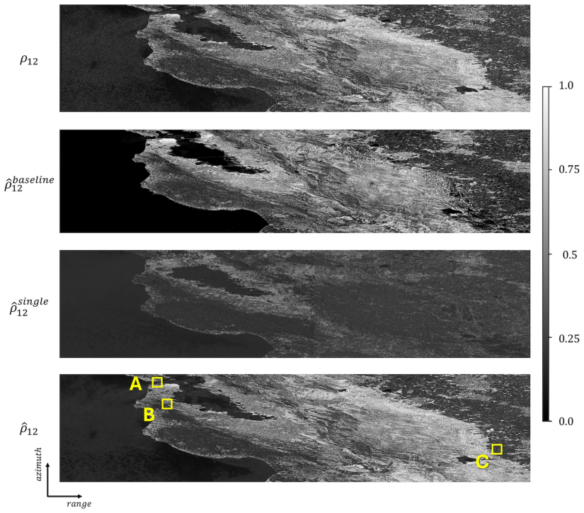
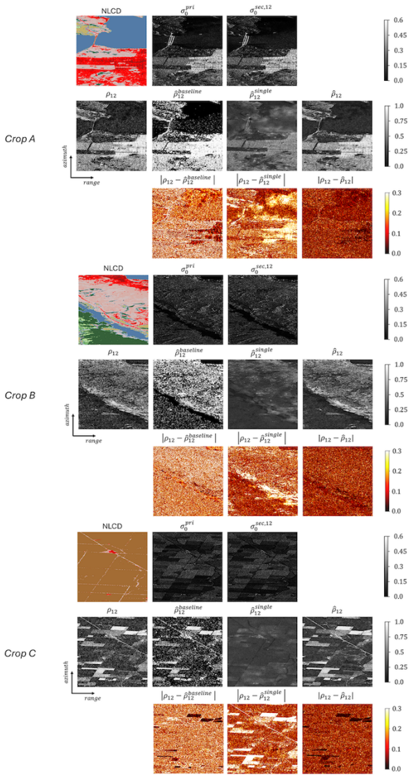
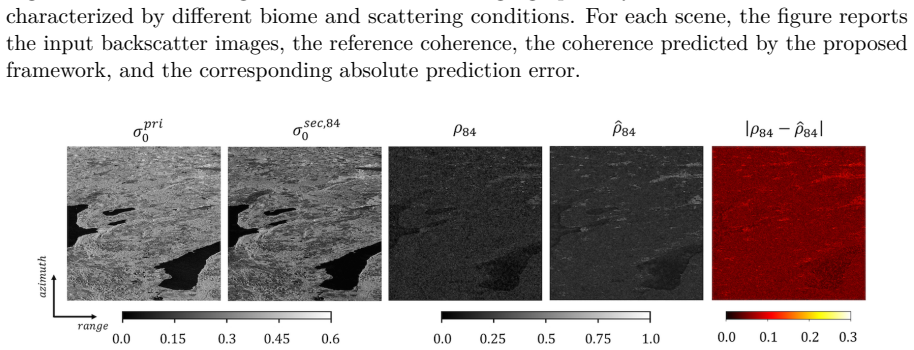
The authors show that a Residual U-Net trained on coherence maps from coregistered Sentinel-1 SLC pairs can predict coherence from backscatter magnitudes alone in detected SAR images. The model delivers high-resolution estimates with improved accuracy over existing intensity-based techniques. It maintains performance across diverse locations and on temporal baselines different from the 12-day training pairs, and functions on globally distributed analysis-ready detected data.
What carries the argument
Residual U-Net that maps pairs of backscatter magnitude images to coherence values.
Load-bearing premise
The statistical mapping from backscatter magnitudes to coherence learned on coregistered 12-day Sentinel-1 SLC pairs transfers to detected SAR images that lack coregistration and may have different radiometric or geometric properties.
What would settle it
The trained model producing lower accuracy than conventional intensity-based coherence estimators when tested on a new collection of detected SAR images from an unseen sensor or geographic region.
If this is right
- Coherence estimation becomes possible on widely distributed analysis-ready detected products without coregistration processing.
- Accuracy exceeds that of existing backscatter-only methods for high-resolution outputs.
- The same model applies to temporal baselines not present in the training set.
- Large-scale mapping and change-monitoring tasks can use standard open data sources such as Google Earth Engine products.
Where Pith is reading between the lines
- Operational pipelines could shift away from SLC data requirements toward simpler detected-image workflows.
- The approach might combine with multi-temporal stacks to refine coherence estimates in time-series applications.
- Transfer tests on data from non-Sentinel-1 sensors would clarify how far the learned magnitude-to-coherence relation extends.
Editorial analysis
A structured set of objections, weighed in public.
Referee Report
Summary. The manuscript proposes a Residual U-Net for regressing InSAR coherence directly from pairs of detected SAR backscatter magnitude images. The network is trained on coherence targets derived from precisely coregistered 12-day Sentinel-1 SLC pairs and is evaluated on multiple datasets spanning coregistered SLC products and analysis-ready data (including GRD) with varying radiometric properties, geometries, and locations. The central claims are that the approach achieves high-resolution coherence estimation without requiring accurate coregistration at inference time, outperforms existing intensity-based methods, and generalizes across unseen geographical locations and temporal baselines.
Significance. If the generalization to misaligned detected-image inputs holds, the method would enable coherence-based applications at scale using globally distributed analysis-ready SAR products (e.g., via Google Earth Engine) without SLC processing or coregistration steps, which would be a practical advance for change monitoring and mapping tasks.
major comments (3)
- [Methods / Training procedure] The training inputs are magnitude pairs taken from precisely coregistered SLC data, yet the central claim requires the same weights to produce usable coherence on detected images that have not been coregistered. No description is given of deliberate misalignment augmentation during training or of controlled experiments that measure performance degradation as a function of geometric offset; this assumption is load-bearing for the claim of operating “without the need for accurate coregistration.”
- [Experiments / Evaluation datasets] Evaluation on “open access analysis-ready data” is reported to demonstrate generalization, but the manuscript does not state whether these test pairs were coregistered, what the typical residual misalignment is, or provide separate metrics for aligned versus unaligned inputs. Without such quantification, the transfer from the training distribution to the claimed inference distribution cannot be verified.
- [Abstract / Results] The abstract asserts “improved accuracy compared to existing intensity-based approaches,” yet the provided summary contains no numerical error metrics, baseline tables, or train/validation split details. If these are absent from the full results section as well, the quantitative support for the accuracy claim is insufficient.
minor comments (1)
- [Abstract] The abstract states that the network “generalizes well … across different temporal baselines that were never seen at training time,” but does not name the specific temporal baselines used in training versus testing.
Simulated Author's Rebuttal
We thank the referee for the constructive and detailed review. We address each major comment point by point below, indicating where revisions will be made to strengthen the manuscript.
read point-by-point responses
-
Referee: [Methods / Training procedure] The training inputs are magnitude pairs taken from precisely coregistered SLC data, yet the central claim requires the same weights to produce usable coherence on detected images that have not been coregistered. No description is given of deliberate misalignment augmentation during training or of controlled experiments that measure performance degradation as a function of geometric offset; this assumption is load-bearing for the claim of operating “without the need for accurate coregistration.”
Authors: We agree that the manuscript does not describe misalignment augmentation or controlled offset experiments. Training used coregistered SLC pairs to obtain reliable coherence targets, with the model intended to generalize to detected products at inference. To support the claim, the revised manuscript will include a new subsection with controlled misalignment experiments reporting accuracy degradation versus offset. revision: yes
-
Referee: [Experiments / Evaluation datasets] Evaluation on “open access analysis-ready data” is reported to demonstrate generalization, but the manuscript does not state whether these test pairs were coregistered, what the typical residual misalignment is, or provide separate metrics for aligned versus unaligned inputs. Without such quantification, the transfer from the training distribution to the claimed inference distribution cannot be verified.
Authors: The analysis-ready datasets (e.g., GRD) were used as distributed without additional coregistration. We will add explicit statements on their processing status and residual misalignment characteristics in the revised manuscript. Separate aligned/unaligned metrics will be provided where the data permits; otherwise we will note the limitation. revision: partial
-
Referee: [Abstract / Results] The abstract asserts “improved accuracy compared to existing intensity-based approaches,” yet the provided summary contains no numerical error metrics, baseline tables, or train/validation split details. If these are absent from the full results section as well, the quantitative support for the accuracy claim is insufficient.
Authors: The full results section contains quantitative error metrics, baseline comparisons, and train/validation details supporting the abstract claim. We will add explicit cross-references from the abstract to the relevant tables and figures in the revised version to make this support clearer. revision: no
Circularity Check
No circularity detected; supervised regression is self-contained
full rationale
The paper trains a Residual U-Net on magnitude pairs extracted from coregistered Sentinel-1 SLC data, with targets given by independently computed InSAR coherence maps from the identical SLC pairs. This constitutes a standard supervised learning setup in which the supervision signal is generated by a separate interferometric process rather than by the network itself or by any self-referential equation. No load-bearing claim reduces to a fitted parameter renamed as a prediction, no self-citation chain is invoked to justify uniqueness, and the generalization statements are presented as empirical results on held-out datasets rather than as derivations that collapse to the training inputs by construction.
Axiom & Free-Parameter Ledger
free parameters (1)
- Residual U-Net weights and training hyperparameters
axioms (1)
- domain assumption Coherence is a learnable function of backscatter magnitude alone
read the original abstract
In this work, we propose a deep learning framework for coherence regression directly from detected SAR images, without the need for accurate coregistration. A Residual U-Net is trained using coherence maps derived from precisely coregistered Sentinel-1 SLC data to learn the relationship between backscatter magnitudes and coherence. The model is trained on 12-day SLC pairs and evaluated across different datasets, including coregistered SLC products and open access analysis-ready data, covering diverse radiometric properties, geometries, and locations. Experimental results demonstrate that the proposed method achieves high-resolution coherence regression with improved accuracy compared to existing intensity-based approaches. The network generalizes well across diverse geographical locations and even across different temporal baselines that were never seen at training time. Additionally, the ability to operate on globally available analysis-ready data, such as ground range detected data, e.g., distributed through Google Earth Engine, enables its large-scale application in mission design, change monitoring, and diverse mapping tasks.
Figures






Reference graph
Works this paper leans on
-
[1]
Aiazzi, L
B. Aiazzi, L. Alparone, S. Baronti, and A. Garzelli. Coherence estimation from multilook incoherent SAR imagery.IEEE Transactions on Geoscience and Remote Sensing, 41(11): 2531–2539, 2003
2003
-
[2]
Chen and H.A
C.W. Chen and H.A. Zebker. Phase unwrapping for large SAR interferograms: statistical segmentation and generalized network models.IEEE Transactions on Geoscience and Remote Sensing, 40(8):1709–1719, 2002
2002
-
[3]
S. R. Cloude and E. Pottier. A review of target decomposition theorems in radar polarimetry. IEEE Transactions on Geoscience and Remote Sensing, 34(2):498–518, 1997
1997
-
[4]
R.J. Dekker. Texture analysis and classification of ERS SAR images for map updating of urban areas in The Netherlands.IEEE Transactions on Geoscience and Remote Sensing, 41(9):1950–1958, 2003
1950
-
[5]
P. C. Dubois, J. van Zyl, and E. T. Engman. A model for the estimation of soil moisture from radar backscatter.IEEE Transactions on Geoscience and Remote Sensing, 33(4): 915–926, 1995
1995
-
[6]
Engdahl and J.M
M.E. Engdahl and J.M. Hyyppa. Land-cover classification using multitemporal ERS-1/2 InSAR data.IEEE Transactions on Geoscience and Remote Sensing, 41(7):1620–1628, 2003
2003
-
[7]
E. T. Engman and J. T. Wang. Evaluation of Three Radar Backscatter Roughness Models Using Soil Moisture Data Collected by the Space Shuttle Flight 41G SIR-B SAR.IEEE Transactions on Geoscience and Remote Sensing, 25(5):709–715, 1987
1987
-
[8]
ESA, Frascati, Italy, version 3.9 edition, 2020
European Space Agency (ESA).Sentinel-1 Product Specification Document. ESA, Frascati, Italy, version 3.9 edition, 2020. URL https://sentinels.copernicus.eu/documents/ 247904/1877131/Sentinel-1-Product-Specification. Accessed: 2025-09-12
2020
-
[9]
The copernicus pod service.Advances in Space Research, 74(6):2615–2648, 2024
Jaime Fernández, Heike Peter, Carlos Fernández, Javier Berzosa, Marc Fernández, Luning Bao, Miguel Ángel Muñoz, Sonia Lara, Eva Terradillos, Pierre Féménias, and Carolina Nogueira. The copernicus pod service.Advances in Space Research, 74(6):2615–2648, 2024
2024
-
[10]
[Online]
Google.Google Earth Engine (GEE). [Online]. Available:https://earthengine.google. com/,
-
[11]
[Online]
Google.GEE: Sentinel-1 GRD dataset. [Online]. Available: https://developers.google. com/earth-engine/datasets/catalog/COPERNICUS_S1_GRD,
-
[12]
[Online]
Google.GEE: Sentinel-1 GRD preprocessing. [Online]. Available:https://developers. google.com/earth-engine/guides/sentinel1#sentinel-1-preprocessing, . 25
-
[13]
M. T. Hallikainen, F. T. Ulaby, M. C. Dobson, M. A. El-Rayes, and L. Wu. Microwave dielectric behavior of wet soil—Part 1: Empirical models and experimental observations. IEEE Transactions on Geoscience and Remote Sensing, 23(1):25–34, 1985
1985
-
[14]
Deep Residual Learning for Image Recognition
Kaiming He, Xiangyu Zhang, Shaoqing Ren, and Jian Sun. Deep Residual Learning for Image Recognition, 2015. URLhttps://arxiv.org/abs/1512.03385
work page internal anchor Pith review Pith/arXiv arXiv 2015
-
[15]
Collin Homer, Jon Dewitz, Limin Yang, Suming Jin, Patrick Danielson, George Xian, John Coulston, Nathaniel Herold, James Wickham, and Kevin Megown. Completion of the 2011 National Land Cover Database for the Conterminous United States – Representing a Decade of Land Cover Change Information.Photogrammetric Engineering & Remote Sensing, 81 (5):345–354, 2015
2011
-
[16]
Jacob, Fernando Vicente-Guijalba, Carlos Lopez-Martinez, Juan M
Alexander W. Jacob, Fernando Vicente-Guijalba, Carlos Lopez-Martinez, Juan M. Lopez- Sanchez, Marius Litzinger, Harald Kristen, Alejandro Mestre-Quereda, Dariusz Ziółkowski, Marco Lavalle, Claudia Notarnicola, Gopika Suresh, Oleg Antropov, Shaojia Ge, Jaan Praks, Yifang Ban, Eric Pottier, Jordi Joan Mallorquí Franquet, Javier Duro, and Marcus E. Engdahl. ...
2020
-
[17]
TanDEM-X: A Satellite Formation for High-Resolution SAR Interferometry.IEEE Transactions on Geoscience and Remote Sensing, 45(11):3317–3341, 2007
Gerhard Krieger, Alberto Moreira, Hauke Fiedler, Irena Hajnsek, Marian Werner, Marwan Younis, and Manfred Zink. TanDEM-X: A Satellite Formation for High-Resolution SAR Interferometry.IEEE Transactions on Geoscience and Remote Sensing, 45(11):3317–3341, 2007
2007
-
[18]
Kuplich, P.J
T.M. Kuplich, P.J. Curran, and P.M. Atkinson. Relating SAR image texture and backscatter to tropical forest biomass. InIGARSS 2003. 2003 IEEE International Geoscience and Remote Sensing Symposium. Proceedings (IEEE Cat. No.03CH37477), volume 4, pages 2872–2874, 2003
2003
-
[19]
TanDEM-X Forest Mapping Using Convolutional Neural Networks.Remote Sensing, 11(24):2980, 2019
Antonio Mazza, Francescopaolo Sica, Paola Rizzoli, and Giuseppe Scarpa. TanDEM-X Forest Mapping Using Convolutional Neural Networks.Remote Sensing, 11(24):2980, 2019
2019
-
[20]
Quick and dirty
A. V. Monti-Guarnieri and C. Prati. SAR interferometry: a "Quick and dirty" coherence estimator for data browsing.IEEE Transactions on Geoscience and Remote Sensing, 35(3): 660–669, 1997
1997
-
[21]
Coherent change detection for multipass sar.IEEE Transactions on Geoscience and Remote Sensing, 56(11):6811–6822, 2018
Andrea Monti-Guarnieri, Maria Antonia Brovelli, Marco Manzoni, Mauro Mari- otti d’Alessandro, Monia Elisa Molinari, and Daniele Oxoli. Coherent change detection for multipass sar.IEEE Transactions on Geoscience and Remote Sensing, 56(11):6811–6822, 2018
2018
-
[22]
Nisar sample data product suite, 2025
NASA. Nisar sample data product suite, 2025. URLhttps://science.nasa.gov/mission/ nisar/sample-data/. Accessed: 2026-04-15
2025
-
[23]
Pinheiro
M. Pinheiro. Increase of sentinel-1a orbital tube: Impact on interferometry. Technical report, Technical Note ESA-EOPG-EOPGMQ-TN-2024-12, 2024
2024
-
[24]
Multi-Temporal Sentinel-1 Backscatter and Coherence for Rainforest Mapping
Andrea Pulella, Rodrigo Aragao Santos, Francescopaolo Sica, Philipp Posovszky, and Paola Rizzoli. Multi-Temporal Sentinel-1 Backscatter and Coherence for Rainforest Mapping. Remote Sensing, 12(5):847, 2020
2020
-
[25]
Raney, T
R.K. Raney, T. Freeman, R.W. Hawkins, and R. Bamler. A plea for radar brightness. In Proceedings of IGARSS ’94 - 1994 IEEE International Geoscience and Remote Sensing Symposium, volume 2, pages 1090–1092, 1994. 26
1994
-
[26]
The SAR2Height framework for urban height map reconstruction from single SAR intensity images.ISPRS Journal of Photogrammetry and Remote Sensing, 211:104–120, 2024
Michael Recla and Michael Schmitt. The SAR2Height framework for urban height map reconstruction from single SAR intensity images.ISPRS Journal of Photogrammetry and Remote Sensing, 211:104–120, 2024
2024
-
[27]
Deep learning for InSAR processing
Francescopaolo Sica. Deep learning for InSAR processing. In Michael Schmitt and Ronny Hänsch, editors,Deep Learning for Synthetic Aperture Radar Remote Sensing, chapter 7, pages 147–173. Elsevier, 2026
2026
-
[28]
Repeat-pass SAR interferometry for land cover classification: a methodology using Sentinel-1 short-time-series.Remote Sensing of Environment, 232:111277, 2019
Francescopaolo Sica, Andrea Pulella, Matteo Nannini, Muriel Pinheiro, and Paola Rizzoli. Repeat-pass SAR interferometry for land cover classification: a methodology using Sentinel-1 short-time-series.Remote Sensing of Environment, 232:111277, 2019
2019
-
[29]
Francescopaolo Sica, Sofie Bretzke, Andrea Pulella, José-Luis Bueso-Bello, Michele Martone, Pau Prats-Iraola, María-José González-Bonilla, Michael Schmitt, and Paola Rizzoli. Insar decorrelation at x-band from the joint tandem-x/paz constellation.IEEE Geoscience and Remote Sensing Letters, 18(12):2107–2111, 2021. doi: 10.1109/LGRS.2020.3014809
-
[30]
Francescopaolo Sica, Giorgia Gobbi, Paola Rizzoli, and Lorenzo Bruzzone.ϕ-Net: Deep Residual Learning for InSAR Parameters Estimation.IEEE Transactions on Geoscience and Remote Sensing, 59(5):3917–3941, 2021
2021
-
[31]
D. Small. Flattening Gamma: Radiometric Terrain Correction for SAR Imagery.IEEE Transactions on Geoscience and Remote Sensing, 49(8):3081–3093, 2011
2011
-
[32]
Stephenson, Tobias Köhne, Eric Zhan, Brent E
Oliver L. Stephenson, Tobias Köhne, Eric Zhan, Brent E. Cahill, Sang-Ho Yun, Zachary E. Ross, and Mark Simons. Deep Learning-Based Damage Mapping With InSAR Coherence Time Series.IEEE Transactions on Geoscience and Remote Sensing, 60:1–17, 2022
2022
-
[33]
Strozzi, P.B.G
T. Strozzi, P.B.G. Dammert, U. Wegmuller, J.-M. Martinez, J.I.H. Askne, A. Beaudoin, and N.T. Hallikainen. Landuse mapping with ers sar interferometry.IEEE Transactions on Geoscience and Remote Sensing, 38(2):766–775, 2000
2000
-
[34]
Touzi, A
R. Touzi, A. Lopes, P. W. Vachon, and C. W. King. Coherence estimation for multilook polsar imagery.IEEE Transactions on Geoscience and Remote Sensing, 42(7):1386–1399, 2004
2004
-
[35]
Minglong Xue, Jian Li, Zheng Zhao, and Qingli Luo. SAR2HEIGHT: Height Estimation from a Single SAR Image in Mountain Areas via Sparse Height and Proxyless Depth-Aware Penalty Neural Architecture Search for U-Net.Remote Sensing, 14(21):5392, 2022
2022
-
[36]
Interferometric Processing of Sentinel-1 TOPS Data.IEEE Transactions on Geoscience and Remote Sensing, 54(4):2220–2234, 2016
Néstor Yagüe-Martínez, Pau Prats-Iraola, Fernando Rodríguez González, Ramon Brcic, Robert Shau, Dirk Geudtner, Michael Eineder, and Richard Bamler. Interferometric Processing of Sentinel-1 TOPS Data.IEEE Transactions on Geoscience and Remote Sensing, 54(4):2220–2234, 2016
2016
-
[37]
H. A. Zebker and R. M. Goldstein. Topographic Mapping from Interferometric SAR Observations.Journal of Geophysical Research, 97(B4):5037–5046, 1992
1992
-
[38]
Zebker and J
H.A. Zebker and J. Villasenor. Decorrelation in interferometric radar echoes.IEEE Transactions on Geoscience and Remote Sensing, 30(5):950–959, 1992. 27
1992
discussion (0)
Sign in with ORCID, Apple, or X to comment. Anyone can read and Pith papers without signing in.