Landslide Detection and Mapping Using Deep Learning Across Multi-Source Satellite Data and Geographic Regions
Pith reviewed 2026-05-21 23:57 UTC · model grok-4.3
The pith
Deep learning models using Sentinel-2 multispectral data and ALOS PALSAR elevation layers detect and map landslides across diverse geographic regions.
A machine-rendered reading of the paper's core claim, the machinery that carries it, and where it could break.
Core claim
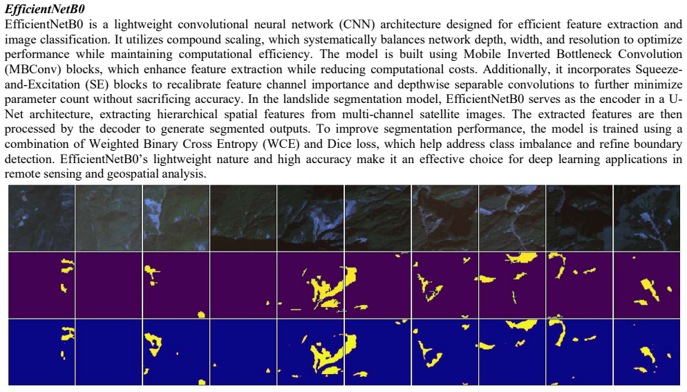
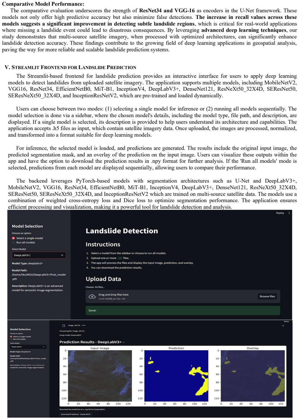
The authors claim that integrating multi-source satellite imagery from Sentinel-2 and ALOS PALSAR with deep learning segmentation models such as U-Net, DeepLabV3+, and Res-Net enables effective landslide detection and mapping. This combination captures critical environmental features including terrain characteristics, vegetation cover, and rainfall effects, producing models that are robust, scalable, and transferable across geographic regions for better disaster preparedness.
What carries the argument
Fusion of Sentinel-2 multispectral bands with ALOS PALSAR-derived slope and DEM layers as input to deep learning segmentation networks including U-Net for pixel-wise landslide classification.
If this is right
- The approach supports development of reliable early warning systems for landslides.
- It improves disaster risk management through automated mapping.
- It aids sustainable land-use planning by identifying high-risk zones.
- It demonstrates potential for creating scalable and transferable prediction models from remote sensing data.
Where Pith is reading between the lines
- Historical satellite archives could be processed with the same pipeline to identify long-term changes in landslide frequency.
- Pairing the detection outputs with near-real-time rainfall observations might extend the method from mapping to short-term forecasting.
- Similar multi-source inputs and models could be tested on other hazards such as debris flows or subsidence.
Load-bearing premise
Models trained on the chosen Sentinel-2 and ALOS PALSAR datasets will maintain useful accuracy when applied to new geographic regions with different terrain, vegetation, or rainfall patterns.
What would settle it
Retraining or testing the models on imagery from a new region with substantially different geology or climate and measuring whether segmentation accuracy falls below a practical threshold for usable mapping.
Figures


read the original abstract
Landslides pose severe threats to infrastructure, economies, and human lives, necessitating accurate detection and predictive mapping across diverse geographic regions. With advancements in deep learning and remote sensing, automated landslide detection has become increasingly effective. This study presents a comprehensive approach integrating multi-source satellite imagery and deep learning models to enhance landslide identification and prediction. We leverage Sentinel-2 multispectral data and ALOS PALSAR-derived slope and Digital Elevation Model (DEM) layers to capture critical environmental features influencing landslide occurrences. Various geospatial analysis techniques are employed to assess the impact of terra in characteristics, vegetation cover, and rainfall on detection accuracy. Additionally, we evaluate the performance of multiple stateof-the-art deep learning segmentation models, including U-Net, DeepLabV3+, and Res-Net, to determine their effectiveness in landslide detection. The proposed framework contributes to the development of reliable early warning systems, improved disaster risk management, and sustainable land-use planning. Our findings provide valuable insights into the potential of deep learning and multi-source remote sensing in creating robust, scalable, and transferable landslide prediction models.
Editorial analysis
A structured set of objections, weighed in public.
Referee Report
Summary. The paper describes a comprehensive approach to landslide detection and mapping by integrating Sentinel-2 multispectral data and ALOS PALSAR-derived slope and DEM layers with deep learning segmentation models such as U-Net, DeepLabV3+, and ResNet. It evaluates model performance and assesses the impact of terrain, vegetation cover, and rainfall on detection accuracy, claiming contributions to early warning systems and transferable prediction models across geographic regions.
Significance. Should the quantitative results and cross-region generalization tests confirm the robustness and transferability of the models, this work would offer valuable insights for disaster risk management and land-use planning by demonstrating effective use of multi-source remote sensing data in deep learning frameworks for natural hazard detection.
major comments (2)
- Abstract: The abstract asserts that multiple models were evaluated and geospatial factors assessed, yet provides no quantitative metrics, data-split details, or cross-region generalization results, leaving the central performance claims unsupported by visible evidence.
- Evaluation section: The transferability claim for 'robust, scalable, and transferable landslide prediction models' rests on an untested assumption; no region-level hold-out protocol is described, so reported scores may reflect intra-region interpolation rather than extrapolation to new terrain, vegetation, or rainfall regimes.
minor comments (2)
- Abstract: Typo 'stateof-the-art' should be 'state-of-the-art'.
- Abstract: Typo 'terra in characteristics' should be 'terrain characteristics'.
Simulated Author's Rebuttal
We thank the referee for their constructive and detailed feedback. We address each major comment below and outline the revisions we will make to strengthen the manuscript.
read point-by-point responses
-
Referee: Abstract: The abstract asserts that multiple models were evaluated and geospatial factors assessed, yet provides no quantitative metrics, data-split details, or cross-region generalization results, leaving the central performance claims unsupported by visible evidence.
Authors: We agree that the abstract would be strengthened by the inclusion of key quantitative results. In the revised manuscript we will update the abstract to report the best-performing model’s IoU and F1 scores, the overall data-split ratios, and a brief statement of the cross-region generalization outcomes. revision: yes
-
Referee: Evaluation section: The transferability claim for 'robust, scalable, and transferable landslide prediction models' rests on an untested assumption; no region-level hold-out protocol is described, so reported scores may reflect intra-region interpolation rather than extrapolation to new terrain, vegetation, or rainfall regimes.
Authors: We acknowledge that the original manuscript did not sufficiently detail the region-level hold-out protocol. The evaluation did include explicit cross-region tests in which models were trained on data from one set of geographic regions and evaluated on completely held-out regions. We will revise the Evaluation section to describe this protocol, including the specific regions reserved for testing and the rationale for ensuring the assessment reflects extrapolation rather than interpolation. revision: yes
Circularity Check
No significant circularity in empirical ML application study
full rationale
The paper is an empirical evaluation applying existing segmentation architectures (U-Net, DeepLabV3+, ResNet) to Sentinel-2 and ALOS PALSAR data for landslide mapping. No mathematical derivations, new equations, fitted parameters renamed as predictions, or ansatzes appear. Claims of robustness and transferability rest on reported IoU/F1 metrics from the chosen datasets rather than any self-referential reduction or self-citation chain that would make the central result equivalent to its inputs by construction. This is a standard empirical comparison with no load-bearing circular steps.
Axiom & Free-Parameter Ledger
axioms (1)
- domain assumption Deep learning segmentation models can learn to identify landslide features from multispectral and elevation satellite data when trained on representative examples.
Lean theorems connected to this paper
-
IndisputableMonolith/Cost/FunctionalEquation.leanwashburn_uniqueness_aczel unclear?
unclearRelation between the paper passage and the cited Recognition theorem.
We leverage Sentinel-2 multispectral data and ALOS PALSAR-derived slope and Digital Elevation Model (DEM) layers... evaluate the performance of multiple state-of-the-art deep learning segmentation models, including U-Net, DeepLabV3+, and Res-Net
-
IndisputableMonolith/Foundation/RealityFromDistinction.leanreality_from_one_distinction unclear?
unclearRelation between the paper passage and the cited Recognition theorem.
The proposed framework contributes to the development of reliable early warning systems...
What do these tags mean?
- matches
- The paper's claim is directly supported by a theorem in the formal canon.
- supports
- The theorem supports part of the paper's argument, but the paper may add assumptions or extra steps.
- extends
- The paper goes beyond the formal theorem; the theorem is a base layer rather than the whole result.
- uses
- The paper appears to rely on the theorem as machinery.
- contradicts
- The paper's claim conflicts with a theorem or certificate in the canon.
- unclear
- Pith found a possible connection, but the passage is too broad, indirect, or ambiguous to say the theorem truly supports the claim.
Reference graph
Works this paper leans on
-
[1]
Estimating the quality of landslide susceptibility models,
F. Guzzetti, P. Reichenbach, F. Ardizzone, M. Cardinali, and M. Galli, “Estimating the quality of landslide susceptibility models,” Geomorphology, vol. 81, no. 1-2, pp. 166–184, 2006
work page 2006
-
[2]
Landslide susceptibility mapping at national scale: a first attempt for Austria,
P. Lima, S. Steger, T. Glade, N. Tilch, L. Schwarz, and A. Kociu, “Landslide susceptibility mapping at national scale: a first attempt for Austria,” in Workshop on World Landslide Forum. Springer, 2017, pp. 943–951
work page 2017
-
[3]
Image-Data-Driven Slope Stability Analysis for Preventing Landslides Using Deep Learning,
B. Azmoon, A. Biniyaz, Z. Liu, and Y. Sun, “Image-Data-Driven Slope Stability Analysis for Preventing Landslides Using Deep Learning,” IEEE Access, vol. 9, pp. 150 623–150 636, 2021
work page 2021
-
[4]
Landslide4Sense: Reference Benchmark Data and Deep Learning Models for Landslide Detection,
O. Ghorbanzadeh, Y. Xu, P. Ghamisi, M. Kopp and D. Kreil, "Landslide4Sense: Reference Benchmark Data and Deep Learning Models for Landslide Detection," in IEEE Transactions on Geoscience and Remote Sensing, vol. 60, pp. 1-17, 2022, Art no. 5633017, doi: 10.1109/TGRS.2022.3215209
-
[5]
Kaushal, A., Gupta, A.K. & Sehgal, V.K. A semantic segmentation framework with UNet-pyramid for landslide prediction using remote sensing data. Sci Rep 14, 30071 (2024). doi: 10.1038/s41598-024-79266-6
-
[6]
Burange, Rahul and Shinde, Harsh and Mutyalwar, Omkar, An Exhaustive Review on Deep Learning for Advanced Landslide Detection and Prediction from Multi-Source Satellite Imagery (February 26, 2025). doi: 10.2139/ssrn.5155990 [7]A Comprehensive Approach to Landslide Detection: Deep Learning and Remote Sensing Integration. (2025). IJARCCE, 14(3). doi: 10.171...
-
[7]
Rainfall and landslide initiation,
F. Guzzetti, S. L. Gariano, S. Peruccacci, M. T. Brunetti, and M. Melillo, “Rainfall and landslide initiation,” Rainfall, pp. 427– 450, 2022. [Online]. Available: https://linkinghub.elsevier.com/retrieve/pii/ B9780128225448000123
work page 2022
-
[8]
K. Dai, Z. Li, Q. Xu, R. Burgmann, D. G. Milledge, R. Tomas, X. Fan, ¨ C. Zhao, X. Liu, J. Peng et al., “Entering the era of earth observationbased landslide warning systems: A novel and exciting framework,” IEEE Geosci. Remote Sens. Mag., vol. 8, no. 1, pp. 136–153, 2020
work page 2020
-
[9]
B. Pradhan, M. N. Jebur, H. Z. M. Shafri, and M. S. Tehrany, “Data fusion technique using wavelet transform and taguchi methods for automatic landslide detection from airborne laser scanning data and quickbird satellite imagery,” IEEE Trans. Geos. Remote Sens., vol. 54, no. 3, pp. 1610–1622, 2015
work page 2015
-
[10]
Comparing landslide inventory maps,
M. Galli, F. Ardizzone, M. Cardinali, F. Guzzetti, and P. Reichenbach, “Comparing landslide inventory maps,” Geomorphology, vol. 94, no. 3-4, pp. 268–289, 2008
work page 2008
-
[11]
Landslides: investigation and mitigation. Chapter 3-Landslide types and processes,
D. M. Cruden and D. J. Varnes, “Landslides: investigation and mitigation. Chapter 3-Landslide types and processes,” Transportation research board special report, no. 247, 1996
work page 1996
-
[12]
B. Yang, T. Xiao, L. Wang, and W. Huang, “Using Complementary Ensemble Empirical Mode Decomposition and Gated Recurrent Unit to Predict Landslide Displacements in Dam Reservoir,” 2022
work page 2022
-
[13]
C. Noviello, S. Verde, V. Zamparelli, G. Fornaro, A. Pauciullo, D. Reale, G. Nicodemo, S. Ferlisi, G. Gulla, and D. Peduto, “Monitoring buildings at landslide risk with sar: A methodology based on the use of multipass interferometric data,” IEEE Geosci. Remote Sens. Mag., vol. 8, no. 1, pp. 91–119, 2020
work page 2020
-
[14]
Prediction of Rainfall Based on Deep Learning and Internet of Things to Prevent Landslide,
C. C. Khaing and T. L. L. Thein, “Prediction of Rainfall Based on Deep Learning and Internet of Things to Prevent Landslide,” in 2020 IEEE 9th Global Conference on Consumer Electronics (GCCE). IEEE, 2020, pp. 190–191
work page 2020
-
[15]
G. Titti, C. van Westen, L. Borgatti, A. Pasuto, and L. Lombardo, “When Enough Is Really Enough? On the Minimum Number of Landslides to Build Reliable Susceptibility Models,” Geosciences, vol. 11, no. 11, p. 469, 2021
work page 2021
-
[16]
O. Ghorbanzadeh, T. Blaschke, K. Gholamnia, S. R. Meena, D. Tiede, and J. Aryal, “Evaluation of different machine learning methods and deep-learning convolutional neural networks for landslide detection,” Remote Sensing, vol. 11, no. 2, p. 196, 2019
work page 2019
discussion (0)
Sign in with ORCID, Apple, or X to comment. Anyone can read and Pith papers without signing in.