REVIEW 2 major objections 1 minor 1 cited by
Absorption-Feature-Guided Distance-Decoupled Estimation and Band Selection for LWIR Hyperspectral Passive Ranging
T0 review · 2 major / 1 minor · reviewed 2026-07-01 · grok-4.3
Pith's one-line read The ADER framework recovers LiDAR-consistent distances from LWIR hyperspectral data by decoupling emissivity via B-spline smoothness and ozone absorption classification.
desk verdict ADER gives a concrete speed-up for LWIR passive ranging via B-splines and ozone cues, but the validation stays mostly qualitative. read the letter →
The pith
A machine-rendered reading of the paper's core claim, the machinery that carries it, and where it could break.
The reading
What carries the argument
Absorption-Guided Distance-Decoupled Estimation and Refinement (ADER) framework, which separates distance from emissivity by B-spline smoothness prior and ozone-based pixel classification followed by type-specific compensation.
What would settle it
A comparison showing that ADER distance maps deviate substantially from independent LiDAR ground truth in scenes where emissivity contains sharp spatial variations that violate the B-spline smoothness prior.
Extended reading notes
Core claim
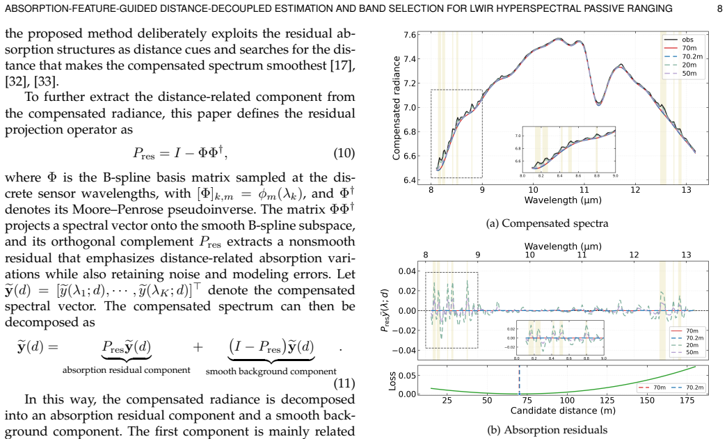
ADER represents emissivity with B-spline control points under a smoothness prior that suppresses overfitting to atmospheric absorption, classifies pixels into emission-dominant and reflection-dominant groups using ozone-absorption cues, compensates path radiance and transmittance to estimate distance by one-dimensional absorption-residual minimization for emission-dominant pixels, refines the estimate with downwelling-radiance compensation for reflection-dominant pixels, and applies greedy band selection based on multi-scene effective Fisher information; experiments on real scenes recover LiDAR-consistent spatial distance structures under both full-band and 20-band settings while improving a
Load-bearing premise
The B-spline smoothness prior on emissivity sufficiently suppresses overfitting to atmospheric absorption structures while still allowing accurate distance recovery.
Editorial extensions
If this is right
- Recovers LiDAR-consistent spatial distance structures in real scenes.
- Maintains performance under both full-band and 20-band settings.
- Improves ranging accuracy in the evaluated regions.
- Achieves approximately two orders of magnitude speedup over public full-band hyperspectral ranging methods.
Reading between the lines
- The pixel classification and compensation strategy could extend to other wavelength ranges that exhibit distinct atmospheric absorption lines.
- Fisher-information band selection might be repurposed to optimize spectral channels for estimating parameters other than distance, such as surface temperature.
- The decoupling of emissivity via smoothness priors may lower computational cost in broader hyperspectral unmixing or material identification tasks.
Editorial analysis
A structured set of objections, weighed in public.
Referee Report
Summary. The manuscript introduces the Absorption-Feature-Guided Distance-Decoupled Estimation and Refinement (ADER) framework for LWIR hyperspectral passive ranging. It represents emissivity via B-splines under a smoothness prior to suppress overfitting to atmospheric absorption, classifies pixels into emission- and reflection-dominant groups using ozone cues, applies path-radiance/transmittance compensation followed by 1-D absorption-residual minimization for emission-dominant pixels and downwelling compensation for reflection-dominant pixels, and performs greedy band selection via multi-scene effective Fisher information. Real-scene experiments are reported to recover LiDAR-consistent distance maps under full-band and 20-band settings, improve accuracy in evaluated regions, and yield ~100x speedup versus a public full-band method.
Significance. If the central performance claims hold under rigorous validation, the work would be significant for remote-sensing applications by providing a computationally tractable solution to the ill-posed distance inversion problem that explicitly exploits sharp atmospheric absorption features while reducing spectral redundancy. The combination of smoothness-constrained B-spline emissivity modeling and pixel-type classification addresses a key practical bottleneck in existing full-band joint-optimization approaches.
major comments (2)
- [Experiments] Experiments section: the central claim of LiDAR-consistent distance recovery and improved ranging accuracy is presented without quantitative error statistics (RMSE, MAE, or correlation with LiDAR ground truth), without description of the spatial regions used for evaluation, without error bars or cross-validation, and without discussion of failure cases. This directly limits assessment of whether the reported spatial structures constitute a substantive improvement.
- [ADER framework] ADER framework description (B-spline smoothness prior): the distance estimate for emission-dominant pixels is obtained via 1-D absorption-residual minimization after compensation; the claim that the B-spline smoothness prior sufficiently decouples emissivity from atmospheric absorption lines (ozone and others) is load-bearing, yet no ablation on the smoothness weight, no recovered emissivity spectra versus laboratory references, and no sensitivity analysis are supplied to confirm the prior operates in the regime that separates the signals rather than trading one bias for another.
minor comments (1)
- [Abstract] Abstract: the reported 'approximately two orders of magnitude speedup' does not identify the exact baseline implementation or hardware platform, reducing reproducibility.
Simulated Author's Rebuttal
Thank you for the constructive feedback. We address the major comments below and will revise the manuscript to strengthen the evaluation and analysis where feasible.
read point-by-point responses
-
Referee: [Experiments] Experiments section: the central claim of LiDAR-consistent distance recovery and improved ranging accuracy is presented without quantitative error statistics (RMSE, MAE, or correlation with LiDAR ground truth), without description of the spatial regions used for evaluation, without error bars or cross-validation, and without discussion of failure cases. This directly limits assessment of whether the reported spatial structures constitute a substantive improvement.
Authors: We agree that quantitative validation metrics are needed to substantiate the claims. In the revised manuscript we will report RMSE, MAE, and correlation coefficients against LiDAR ground truth for the evaluated regions, explicitly describe the spatial regions (e.g., building facades, vegetation, and road surfaces shown in the figures), include error bars or standard deviations across scenes, and discuss observed failure cases such as low-signal or strongly reflective pixels. These additions will be computed from the existing LiDAR-aligned data. revision: yes
-
Referee: [ADER framework] ADER framework description (B-spline smoothness prior): the distance estimate for emission-dominant pixels is obtained via 1-D absorption-residual minimization after compensation; the claim that the B-spline smoothness prior sufficiently decouples emissivity from atmospheric absorption lines (ozone and others) is load-bearing, yet no ablation on the smoothness weight, no recovered emissivity spectra versus laboratory references, and no sensitivity analysis are supplied to confirm the prior operates in the regime that separates the signals rather than trading one bias for another.
Authors: We will add an ablation study on the smoothness weight λ and a sensitivity analysis showing its impact on distance estimates across scenes. We will also include representative recovered emissivity spectra from the real scenes to illustrate the effect of the prior. Laboratory reference emissivity spectra for the precise materials present in the outdoor scenes are unavailable, so direct comparisons cannot be provided. revision: partial
- Direct comparison of recovered emissivity spectra against laboratory references, because laboratory emissivity data for the specific real-scene materials are not available.
Circularity Check
No circularity detected in derivation chain
full rationale
The ADER framework is constructed from the standard radiative-transfer equation by adding an explicit B-spline emissivity representation under a smoothness prior, ozone-based pixel classification, and separate 1-D residual minimization for emission-dominant pixels plus downwelling compensation for reflection-dominant pixels. Distance recovery is obtained by direct optimization after path compensation rather than by re-using any fitted parameter or self-defined quantity from the same data; band selection uses multi-scene Fisher information on the distance parameter. No self-citations appear as load-bearing steps, no ansatz is smuggled via prior work, and no prediction reduces to its own input by construction. The derivation therefore remains independent of the target outputs.
Assumptions & free parameters
Cite this review
Pith. "Pith review of Absorption-Feature-Guided Distance-Decoupled Estimation and Band Selection for LWIR Hyperspectral Passive Ranging." pith.science (2026). https://pith.science/paper/4H7Z2TYO
@misc{pith2026260631824,
  author       = {Pith},
  title        = {Pith review of: Absorption-Feature-Guided Distance-Decoupled Estimation and Band Selection for LWIR Hyperspectral Passive Ranging},
  year         = {2026},
  howpublished = {\url{https://pith.science/paper/4H7Z2TYO}},
  note         = {Machine review of arXiv:2606.31824}
}
read the original abstract
Long-wave infrared (LWIR) hyperspectral observations contain distance-dependent atmospheric absorption signatures, providing a physical basis for long-range passive ranging. However, in natural scenes, these signatures are nonlinearly coupled with target temperature, material emissivity, and path radiance, making distance inversion from observed radiance ill posed. Existing methods typically rely on full-band measurements and pixel-wise joint optimization, which is computationally expensive and does not explicitly exploit sharp atmospheric absorption structures. This paper proposes an Absorption-Guided Distance-Decoupled Estimation and Refinement (ADER) framework for LWIR hyperspectral passive ranging. ADER represents emissivity with B-spline control points under a smoothness prior, suppressing overfitting to atmospheric absorption structures and enabling distance-decoupled estimation. It further uses ozone-absorption cues to classify pixels into emission-dominant and reflection-dominant groups. For emission-dominant pixels, ADER compensates path radiance and transmittance and estimates distance by one-dimensional absorption-residual minimization. For reflection-dominant pixels, ADER refines the initial estimate using downwelling-radiance compensation based on the complete radiative model. To reduce spectral redundancy, ADER also introduces a greedy band selection strategy based on multi-scene effective Fisher information for the distance parameter. Experiments on real scenes show that ADER recovers LiDAR-consistent spatial distance structures under both full-band and 20-band settings, improves ranging accuracy in the evaluated regions, and achieves approximately two orders of magnitude speedup over a public full-band hyperspectral ranging method.
Figures


Figures from the paper (9 more)




Forward citations
Cited by 1 Pith paper
-
T$^2$exture: Sparsely Perturbed Thermal-to-Texture Imaging
A two-stage framework reconstructs dense thermal texture sequences from dense passive frames and sparse actively illuminated keyframes, using adapted video frame interpolation.
Reference graph
Works this paper leans on
-
[1]
J. Rapp, J. Tachella, Y. Altmann, S. McLaughlin, and V . K. Goyal, “Advances in single-photon lidar for autonomous vehicles: Work- ing principles, challenges, and recent advances,”IEEE Signal Pro- cessing Magazine, vol. 37, no. 4, pp. 62–71, 2020
work page 2020
-
[2]
Lidar measurement of snow depth: A review,
J. S. Deems, T. H. Painter, and D. C. Finnegan, “Lidar measurement of snow depth: A review,”Journal of Glaciology, vol. 59, no. 215, pp. 467–479, 2013
work page 2013
-
[3]
Evaluation of HoloLens tracking and depth sensing for indoor mapping applications,
P . H ¨ubner, K. Clintworth, Q. Liu, M. Weinmann, and S. Wursthorn, “Evaluation of HoloLens tracking and depth sensing for indoor mapping applications,”Sensors, vol. 20, no. 4, p. 1021, 2020. ABSORPTION-FEATURE-GUIDED DISTANCE-DECOUPLED ESTIMATION AND BAND SELECTION FOR LWIR HYPERSPECTRAL PASSIVE RANGING 17
work page 2020
-
[4]
An overview of lidar imaging systems for autonomous vehicles,
S. Royo and M. Ballesta-Garcia, “An overview of lidar imaging systems for autonomous vehicles,”Applied Sciences, vol. 9, no. 19, p. 4093, 2019
work page 2019
-
[5]
Stereo visual SLAM for autonomous vehicles: A review,
B. Gao, H. Lang, and J. Ren, “Stereo visual SLAM for autonomous vehicles: A review,” in2020 IEEE International Conference on Sys- tems, Man, and Cybernetics (SMC), 2020, pp. 1316–1322
work page 2020
-
[6]
Digging into self-supervised monocular depth estimation,
C. Godard, O. Mac Aodha, M. Firman, and G. J. Brostow, “Digging into self-supervised monocular depth estimation,” inProceedings of the IEEE/CVF International Conference on Computer Vision (ICCV), 2019, pp. 3827–3837
work page 2019
-
[7]
K. Wang, Z. Zhang, Z. Yan, X. Li, B. Xu, J. Li, and J. Yang, “Regu- larizing nighttime weirdness: Efficient self-supervised monocular depth estimation in the dark,” inProceedings of the IEEE/CVF In- ternational Conference on Computer Vision (ICCV), 2021, pp. 16 055– 16 064
work page 2021
-
[8]
FoggyStereo: Stereo matching with fog vol- ume representation,
C. Yao and L. Yu, “FoggyStereo: Stereo matching with fog vol- ume representation,” inProceedings of the IEEE/CVF Conference on Computer Vision and Pattern Recognition (CVPR), 2022, pp. 13 043– 13 052
work page 2022
Show all 53 references
-
[9]
Robust monocular depth estimation under challenging condi- tions,
S. Gasperini, N. Morbitzer, H. Jung, N. Navab, and F. Tombari, “Robust monocular depth estimation under challenging condi- tions,” inProceedings of the IEEE/CVF International Conference on Computer Vision (ICCV), 2023, pp. 8177–8186
2023
-
[10]
Heat-assisted detection and ranging,
F. Bao, X. Wang, S. H. Sureshbabu, G. Sreekumar, L. Yang, V . Ag- garwal, V . N. Boddeti, and Z. Jacob, “Heat-assisted detection and ranging,”Nature, vol. 619, pp. 743–748, 2023
2023
-
[11]
Shape from thermal radiation: Passive ranging using multi- spectral LWIR measurements,
Y. Nagase, T. Kushida, K. Tanaka, T. Funatomi, and Y. Mukaigawa, “Shape from thermal radiation: Passive ranging using multi- spectral LWIR measurements,” inProceedings of the IEEE/CVF Conference on Computer Vision and Pattern Recognition (CVPR), 2022, pp. 12 661–12 671
2022
-
[12]
Absorption-based, passive range imaging from hyper- spectral thermal measurements,
U. Dorken Gallastegi, H. Rueda-Chac ´on, M. J. Stevens, and V . K. Goyal, “Absorption-based, passive range imaging from hyper- spectral thermal measurements,”IEEE Transactions on Pattern Analysis and Machine Intelligence, vol. 47, no. 5, pp. 4044–4060, 2025
2025
-
[13]
Longwave infrared hyperspectral imaging: Principles, progress, and challenges,
D. Manolakis, M. Pieper, E. Truslow, R. Lockwood, A. Weisner, J. Jacobson, and T. Cooley, “Longwave infrared hyperspectral imaging: Principles, progress, and challenges,”IEEE Geoscience and Remote Sensing Magazine, vol. 7, no. 2, pp. 72–100, 2019
2019
-
[14]
D. G. Manolakis, R. B. Lockwood, and T. W. Cooley,Hyperspectral Imaging Remote Sensing: Physics, Sensors, and Algorithms. Cam- bridge University Press, 2016
2016
-
[15]
M. T. Eismann,Hyperspectral Remote Sensing. SPIE Press, 2012
2012
-
[16]
Absorption-based hyperspectral thermal ranging: Perfor- mance analyses, optimization, and simulations,
U. Dorken Gallastegi, H. Rueda-Chac ´on, M. J. Stevens, and V . K. Goyal, “Absorption-based hyperspectral thermal ranging: Perfor- mance analyses, optimization, and simulations,”Optics Express, vol. 32, no. 1, pp. 151–166, 2024
2024
-
[17]
An in-scene method for atmospheric compensation of thermal hyperspectral data,
S. J. Young, B. R. Johnson, and J. A. Hackwell, “An in-scene method for atmospheric compensation of thermal hyperspectral data,”Journal of Geophysical Research: Atmospheres, vol. 107, no. D24, p. 4774, 2002
2002
-
[18]
AT2ES: Simultaneous atmospheric transmittance-temperature-emissivity separation using online up- per midwave infrared hyperspectral images,
S. Kim, J. Shin, and S. Kim, “AT2ES: Simultaneous atmospheric transmittance-temperature-emissivity separation using online up- per midwave infrared hyperspectral images,”Remote Sensing, vol. 13, no. 7, p. 1249, 2021
2021
-
[19]
Depth sensing by near-infrared light absorption in water,
Y. Asano, Y. Zheng, K. Nishino, and I. Sato, “Depth sensing by near-infrared light absorption in water,”IEEE Transactions on Pattern Analysis and Machine Intelligence, vol. 43, no. 8, pp. 2611– 2622, 2021
2021
-
[20]
Affine transform representation for reducing calibration cost on absorption-based LWIR depth sensing,
T. Kushida, R. Nakamura, H. Matsuda, W. Chen, and K. Tanaka, “Affine transform representation for reducing calibration cost on absorption-based LWIR depth sensing,”Scientific Reports, vol. 14, no. 1, p. 26429, 2024
2024
-
[21]
Ozone cues mit- igate reflected downwelling radiance in LWIR absorption-based ranging,
U. Dorken Gallastegi, W. Shangguan, V . Choudhary, A. Agarwal, H. Rueda-Chac´on, M. J. Stevens, and V . K. Goyal, “Ozone cues mit- igate reflected downwelling radiance in LWIR absorption-based ranging,”IEEE Transactions on Computational Imaging, vol. 12, pp. 587–600, 2026
2026
-
[22]
Hyperspectral remote sensing data analysis and future challenges,
J. M. Bioucas-Dias, A. Plaza, G. Camps-Valls, P . Scheunders, N. M. Nasrabadi, and J. Chanussot, “Hyperspectral remote sensing data analysis and future challenges,”IEEE Geoscience and Remote Sens- ing Magazine, vol. 1, no. 2, pp. 6–36, 2013
2013
-
[23]
Feature extraction for hyperspectral imagery: The evolution from shallow to deep: Overview and toolbox,
B. Rasti, D. Hong, R. Hang, P . Ghamisi, X. Kang, J. Chanussot, and J. A. Benediktsson, “Feature extraction for hyperspectral imagery: The evolution from shallow to deep: Overview and toolbox,”IEEE Geoscience and Remote Sensing Magazine, vol. 8, no. 4, pp. 60–88, 2020
2020
-
[24]
A survey of band selection techniques for hyperspectral image classification,
S. S. Sawant and M. Prabukumar, “A survey of band selection techniques for hyperspectral image classification,”Journal of Spec- tral Imaging, vol. 9, p. a5, 2020
2020
-
[25]
Passive infrared ranging,
N. K. Leonpacher, “Passive infrared ranging,” Master’s thesis, Air Force Institute of Technology, 1983
1983
-
[26]
Passive ranging using atmospheric oxygen absorp- tion spectra,
M. R. Hawks, “Passive ranging using atmospheric oxygen absorp- tion spectra,” Ph.D. dissertation, Air Force Institute of Technology, 2006
2006
-
[27]
Passive ranging of dynamic rocket plumes using infrared and visible oxygen attenuation,
R. A. Vincent and M. R. Hawks, “Passive ranging of dynamic rocket plumes using infrared and visible oxygen attenuation,” in Acquisition, Tracking, Pointing, and Laser Systems Technologies XXV, ser. Proceedings of SPIE, vol. 8052, 2011, p. 80520D
2011
-
[28]
Monocular passive ranging by an optical system with band pass filtering,
J. R. Anderson, “Monocular passive ranging by an optical system with band pass filtering,” Master’s thesis, Air Force Institute of Technology, 2010
2010
-
[29]
Short- range demonstrations of monocular passive ranging using O 2 absorption spectra,
M. R. Hawks, R. A. Vincent, J. Martin, and G. P . Perram, “Short- range demonstrations of monocular passive ranging using O 2 absorption spectra,”Applied Spectroscopy, vol. 67, no. 5, pp. 513– 519, 2013
2013
-
[30]
Passive ranging using a filter- based non-imaging method based on oxygen absorption,
H. Yu, B. Liu, Z. Yan, and Y. Zhang, “Passive ranging using a filter- based non-imaging method based on oxygen absorption,”Applied Optics, vol. 56, no. 28, pp. 7803–7807, 2017
2017
-
[31]
Eleven years of ground–air temperature tracking over different land cover types,
V . Cermak, L. Bodri, M. Kresl, P . Dedecek, and J. Safanda, “Eleven years of ground–air temperature tracking over different land cover types,”International Journal of Climatology, vol. 37, no. 2, pp. 1084– 1099, 2017
2017
-
[32]
Au- tonomous atmospheric compensation (AAC) of high resolution hyperspectral thermal infrared remote-sensing imagery,
D. Gu, A. R. Gillespie, A. B. Kahle, and F. D. Palluconi, “Au- tonomous atmospheric compensation (AAC) of high resolution hyperspectral thermal infrared remote-sensing imagery,”IEEE Transactions on Geoscience and Remote Sensing, vol. 38, no. 6, pp. 2557–2570, 2000
2000
-
[33]
Coupled subspace-based atmospheric compensation of LWIR hyperspectral data,
N. Acito, M. Diani, and G. Corsini, “Coupled subspace-based atmospheric compensation of LWIR hyperspectral data,”IEEE Transactions on Geoscience and Remote Sensing, vol. 57, no. 8, pp. 5224–5238, 2019
2019
-
[34]
A temperature and emissivity separation algorithm for advanced spaceborne thermal emission and reflec- tion radiometer (ASTER) images,
A. R. Gillespie, S. Rokugawa, T. Matsunaga, J. S. Cothern, S. J. Hook, and A. B. Kahle, “A temperature and emissivity separation algorithm for advanced spaceborne thermal emission and reflec- tion radiometer (ASTER) images,”IEEE Transactions on Geoscience and Remote Sensing, v...
1998
-
[35]
Temperature and emissivity retrievals from hyperspectral thermal infrared data using linear spectral emissivity constraint,
N. Wang, H. Wu, F. Nerry, C. Li, and Z.-L. Li, “Temperature and emissivity retrievals from hyperspectral thermal infrared data using linear spectral emissivity constraint,”IEEE Transactions on Geoscience and Remote Sensing, vol. 49, no. 4, pp. 1291–1303, 2011
2011
-
[36]
Land surface temperature and emissivity retrieval from field-measured hyperspectral thermal infrared data using wavelet transform,
Y.-Z. Zhang, H. Wu, X.-G. Jiang, Y.-Z. Jiang, Z.-X. Liu, and F. Nerry, “Land surface temperature and emissivity retrieval from field-measured hyperspectral thermal infrared data using wavelet transform,”Remote Sensing, vol. 9, no. 5, p. 454, 2017
2017
-
[37]
Airborne thermal infrared hyperspectral image temperature and emissivity retrieval based on inter-channel correlated automatic atmospheric compensation and TES,
D. Wang, L. Cao, L. Gao, and Y. Zhong, “Airborne thermal infrared hyperspectral image temperature and emissivity retrieval based on inter-channel correlated automatic atmospheric compensation and TES,”Remote Sensing of Environment, vol. 315, p. 114410, 2024
2024
-
[38]
Universal computational thermal imaging overcoming the ghosting effect,
H. Xu, D. Wang, C. Zhao, J. Chen, J. Lin, L. Cao, Y. Zhong, Y. She, and F. Bao, “Universal computational thermal imaging overcoming the ghosting effect,” 2026
2026
-
[39]
HADAR-based thermal infrared hyperspectral image restora- tion,
C. Dai, J. Lin, B. Song, Y. Chen, J. Chen, X. Yuan, and F. Bao, “HADAR-based thermal infrared hyperspectral image restora- tion,” 2026
2026
-
[40]
A symmetric sparse repre- sentation based band selection method for hyperspectral imagery classification,
W. Sun, M. Jiang, W. Li, and Y. Liu, “A symmetric sparse repre- sentation based band selection method for hyperspectral imagery classification,”Remote Sensing, vol. 8, no. 3, p. 238, 2016
2016
-
[41]
Band subset selection for hyperspectral image classification,
C. Yu, M. Song, and C.-I. Chang, “Band subset selection for hyperspectral image classification,”Remote Sensing, vol. 10, no. 1, p. 113, 2018
2018
-
[42]
Unsupervised hyperspectral band selec- tion using spectral–spatial iterative greedy algorithm,
X. Yang and W. Wang, “Unsupervised hyperspectral band selec- tion using spectral–spatial iterative greedy algorithm,”Sensors, vol. 25, no. 18, p. 5638, 2025
2025
-
[43]
MODTRAN6: A major upgrade of the MOD- TRAN radiative transfer code,
A. Berk, P . Conforti, R. Kennett, T. Perkins, F. Hawes, and J. van den Bosch, “MODTRAN6: A major upgrade of the MOD- TRAN radiative transfer code,” inAlgorithms and Technologies for Multispectral, Hyperspectral, and Ultraspectral Imagery XX, vol. 9088. SPIE, 2014, p. 90880H
2014
-
[44]
The HITRAN2020 molecular spectroscopic database,
I. E. Gordon, L. S. Rothman, R. J. Hargreaves, R. Hashemi, E. V . Karlovets, F. M. Skinner, E. K. Conway, C. Hill, R. V . Kochanov, Y. Tan, P . Wcisło, A. A. Finenko, K. Nelson, P . F. Bernath, M. Birk, V . Boudon, A. Campargue, K. V . Chance, A. Coustenis, B. J. Drouin et al....
2022
-
[45]
The ECOSTRESS spectral library version 1.0,
S. K. Meerdink, S. J. Hook, D. A. Roberts, and E. A. Abbott, “The ECOSTRESS spectral library version 1.0,”Remote Sensing of Environment, vol. 230, p. 111196, 2019
2019
-
[46]
The ASTER spectral library version 2.0,
A. M. Baldridge, S. J. Hook, C. I. Grove, and G. Rivera, “The ASTER spectral library version 2.0,”Remote Sensing of Environment, vol. 113, no. 4, pp. 711–715, 2009
2009
-
[47]
Iterative retrieval of surface emissivity and tempera- ture for a hyperspectral sensor,
C. C. Borel, “Iterative retrieval of surface emissivity and tempera- ture for a hyperspectral sensor,” Los Alamos National Laboratory, Tech. Rep., 1997
1997
-
[48]
S. M. Kay,Fundamentals of Statistical Signal Processing, Volume I: Estimation Theory. Prentice Hall, 1993
1993
-
[49]
Adam: A method for stochastic optimiza- tion,
D. P . Kingma and J. Ba, “Adam: A method for stochastic optimiza- tion,” inInternational Conference on Learning Representations, 2015
2015
-
[50]
Hyperspectral band selection: A review,
W. Sun and Q. Du, “Hyperspectral band selection: A review,”IEEE Geoscience and Remote Sensing Magazine, vol. 7, no. 2, pp. 118–139, 2019
2019
-
[51]
Sensor selection via convex optimization,
S. Joshi and S. Boyd, “Sensor selection via convex optimization,” IEEE Transactions on Signal Processing, vol. 57, no. 2, pp. 451–462, 2009
2009
-
[52]
Near-optimal sensor placements in gaussian processes: Theory, efficient algorithms and empirical studies,
A. Krause, A. Singh, and C. Guestrin, “Near-optimal sensor placements in gaussian processes: Theory, efficient algorithms and empirical studies,”Journal of Machine Learning Research, vol. 9, pp. 235–284, 2008
2008
-
[53]
DARPA Invisible Headlights Dataset,
Kitware, “DARPA Invisible Headlights Dataset,” Registry of Open Data on AWS, 2021, multi-sensor off-road navigation dataset with visible, hyperspectral, polarimetric, broadband, and LiDAR data
2021
Reviewed July 1, 2026 · model on record in the stance chip above.
Discussion (0). Continue with ORCID to comment.