REVIEW 4 major objections 5 minor 24 references
TrajSceneLLM: A Multimodal Perspective on Semantic GPS Trajectory Analysis
T0 review · 4 major / 5 minor · reviewed 2026-08-15 · deepseek-v4-flash
Pith's one-line read The paper claims that TrajSceneLLM, which concatenates map-image and LLM-text embeddings, reaches 86.8% accuracy on travel mode identification, beating the compared baselines by 2.4 points.
desk verdict Nice multimodal recipe for TMI with public code, but the SOTA claim rests on an uncontrolled comparison that needs a tighter protocol before it holds. read the letter →
The pith
A machine-rendered reading of the paper's core claim, the machinery that carries it, and where it could break.
The reading
What carries the argument
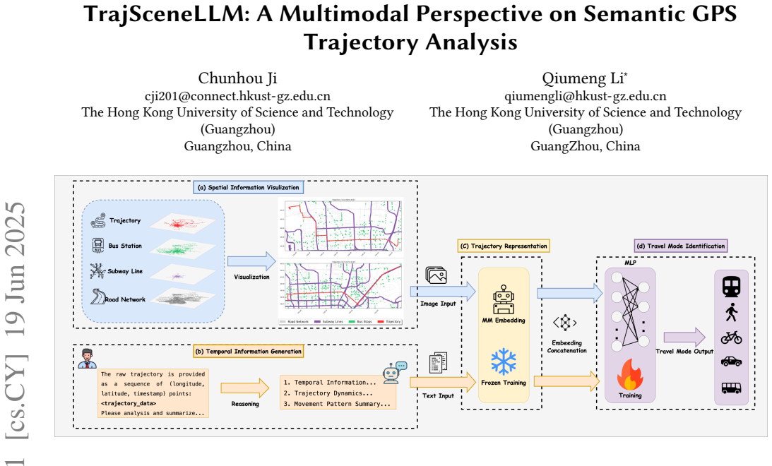
The trajectory scene embedding is the concatenation of two separate embeddings of the same trajectory segment: one from a vision-language model looking at a rendered map image with map layers such as road network, subway lines, and bus stops overlaid, and one from the same model reading a text produced by a reasoning LLM that lists temporal features and movement dynamics (start and end times, duration, inactivity, speed profile, turn frequency, detour index). These two vectors are concatenated and fed to a simple MLP for classification. The concatenation operation itself is load-bearing: the paper reports 86.8% accuracy with concatenation versus 83.5% with a fusion combination, and the two single-modality ablations each lose several points.
What would settle it
Re-run the exact classifiers on the same training and test partition used by the strongest baseline, with the same five modes, and check whether the 86.8% accuracy and the reported ablation differences reproduce; if the gap over 84.4% disappears or reverses, the claimed advantage is an artifact of the comparison setup.
Extended reading notes
Core claim
The central claim is that composing visual-spatial and textual-temporal modalities produces a richer, more discriminative trajectory representation than either alone or than engineered features. Concretely, the paper reports that concatenated map-image and LLM-text embeddings reach 86.8% accuracy on the travel-mode identification task, a 2.4% improvement over the strongest baseline it evaluates. The ablations support the composition claim: removing the map image drops accuracy to 82.8%, removing the LLM text drops it to 81.9%, and feeding the raw embeddings of a single modality directly gives only about 48.5%. Concatenation also beats a learned fusion of the same modalities (86.8% versus 83.5%). The paper concludes that the two modalities carry complementary, non-redundant evidence and that the framework captures deep spatio-temporal dependencies while reducing reliance on handcrafted features.
Load-bearing premise
The claim that 86.8% is a state-of-the-art gain assumes the GeoLife train/test split and the set of five travel modes used in this paper are identical to those used by the compared baselines, since the paper reports only accuracy numbers and does not demonstrate that the evaluation settings match.
Editorial extensions
If this is right
- If the reported result holds, travel mode identification can be solved without handcrafted feature engineering: map renders plus LLM-written text, embedded and concatenated, feed a simple MLP classifier.
- The ablations imply the visual map context and the textual temporal summary each carry about four accuracy points of independent signal, so removing either leaves a materially weaker representation.
- Because the LLM is used only to produce embeddings and classification is decoupled, the same trajectory scene embeddings could in principle be reused for other trajectory tasks without rerunning the model.
- The concatenation-versus-fusion comparison suggests that for this setting, keeping the two modalities as separate vectors is better than merging them into a fused representation.
Reading between the lines
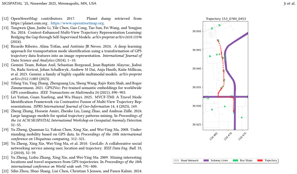
- A natural extension the paper does not test is whether the same recipe transfers to trajectory clustering, next-location prediction, or trip-purpose inference; if the embedding captures scene semantics rather than just mode-discriminative cues, those tasks should also improve.
- The generated text contains explicit numeric quantities (duration, detour index, stop lengths). One could test whether exposing these numbers directly to the classifier, or checking their accuracy against ground-truth computations, explains part of the gain or introduces a hidden leakage channel.
- The 'direct' raw-embedding baselines (about 48.5%) suggest the improvement is not from LLM representation strength alone but from the concatenation of aligned modalities; a testable prediction is that modality alignment or normalization strongly affects the final accuracy.
Signed reviews
Editorial analysis
A structured set of objections, weighed in public.
Referee Report
Summary. TrajSceneLLM (Ji and Li) proposes a multimodal representation for GPS trajectories: trajectories are rendered as map images with OSM context (the visual-spatial modality) and converted into textual descriptions by DeepSeek-R1 from raw coordinate/time sequences (the textual-temporal modality). Seed1.5-VL generates separate embeddings for each modality; these embeddings are concatenated (or fused) and fed to an MLP classifier for Travel Mode Identification on the GeoLife dataset. The paper reports 86.8% accuracy for the concatenated version, exceeding SVM, RF, MASO-MSF, and several ablations, and claims state-of-the-art performance. Ablations that remove either modality drop accuracy, which the authors interpret as evidence that the two modalities are complementary. Code and dataset links are provided.
Significance. If the reported comparison is valid, the paper offers a practical recipe: off-the-shelf multimodal LLM embeddings, combined with a simple classifier, can outperform handcrafted-feature and dedicated semantic models on TMI. The framework is simple, the code is public, and the ablation design cleanly isolates the contribution of each modality. However, the 'state-of-the-art' conclusion rests on a single uncontrolled comparison, and the manuscript currently provides no evidence that the 2.4% gain over MASO-MSF is not an artifact of different evaluation protocols. The contribution is therefore a promising demonstration rather than a validated SOTA result.
major comments (4)
- [Section 3, Table 1] The central SOTA claim (86.8% vs. MASO-MSF's 84.4%) is not supported as reported because the manuscript does not specify the GeoLife train/test split, trajectory segmentation, or class set used for the baselines. GeoLife's raw labels include taxi, and published TMI protocols often use six classes; the paper uses five modes and never states whether MASO-MSF and the traditional classifiers were evaluated under this same five-class protocol or quoted from prior work. Without this information, the 2.4% gain may reflect protocol differences rather than method quality, and the comparison is not valid. The authors should either re-run all baselines under exactly the same split, segmentation, and class set, or clearly report the source of each number and justify comparability.
- [Section 3, Table 1] No error bars, multiple seeds, or significance tests are reported for any row; a 2.4% gap is small relative to typical variation from random seeds and data splits in GeoLife experiments. In addition, the 'Direct' baseline is underspecified because no classifier or training procedure is described, and recent published baselines such as MVCF-TMI (ref. [17]) are cited but not included in Table 1. Please provide means and standard deviations over at least five random seeds/splits, a paired significance test for the main comparison, and a concrete description of the Direct baseline.
- [Appendix A and Section 2.1.2] The textual modality is generated by prompting DeepSeek-R1 to extract closed-form handcrafted features (average speed, detour index, turn frequency, speed variation) from the raw coordinates. This undercuts the abstract's claim that the method reduces reliance on handcrafted features and makes it difficult to tell whether the improvement comes from LLM reasoning about raw data or from feeding the same handcrafted statistics (reformatted as text) into the multimodal encoder. Please clarify the division of labor and rephrase the handcrafted-feature claim to match what is actually computed.
- [Section 2.1.2 and Appendix A] The prompt template for DeepSeek-R1 is never given; only an example of the output is shown. Because the content of the textual summaries is a free parameter that can encode the authors' expectations (for example, instructing the LLM to list mode-discriminative features such as stops and detour index), the prompt must be included in the appendix or supplement for reproducibility and to rule out prompt-induced label leakage. Also, the MLP architecture and training hyperparameters are not reported, so the classifier component is not reproducible as stated.
minor comments (5)
- [Section 1] Please proofread punctuation; for example, 'mobility behaviors, The main' should be 'mobility behaviors. The main'.
- [Section 2.1.1] The parenthetical 'Appendix A(Figure 2)' in the text should be written as 'Appendix A (Figure 2)' for clarity.
- [Table 1] The rows 'Direct(w/o. text)' and 'Direct(w/o. image)' are difficult to interpret; a footnote should explain whether these are single-modality raw LLM embeddings produced by the same Seed1.5-VL encoder used in the Ours rows.
- [Appendix A] The example textual summary for the bus trajectory concludes 'consistent with cycling or slow motorized travel'; this may be a realistic reflection of GeoLife ambiguity, but the main text should note explicitly that the LLM output is not required to name the mode, so that readers do not suspect the prompt leaks the label.
- [Section 3] The phrase 'significant improvement' is used without statistical support; please either soften it to 'numerical improvement' or provide the significance test referenced in Major Comment 2.
Circularity Check
No circularity: TrajSceneLLM's TMI accuracy is an empirical result not forced by construction or self-citation.
full rationale
The paper's pipeline is: raw GPS segments are converted into OSM map images and into DeepSeek-R1-generated textual descriptions of temporal and dynamic features; Seed1.5-VL produces separate embeddings; the embeddings are concatenated and fed to an MLP trained for travel-mode classification on GeoLife. The reported 86.8% accuracy is a measured downstream outcome, not a quantity that is definitionally equal to any input or fitted parameter. The multimodal embeddings are generated without access to the travel-mode labels, and the MLP is trained separately, so there is no fitted-input-called-prediction pattern. There are no load-bearing self-citations: references to Seed1.5-VL and DeepSeek-R1 are external model technical reports, not prior work by these authors, and no uniqueness claim is imported from the authors' own papers. The ablations (w/o image, w/o text, fusion vs. concatenation) are internal comparisons that support the thesis empirically rather than assuming it. Concerns that the SOTA comparison with MASO-MSF may be uncontrolled (different splits, class sets, or missing error bars) are correctness and reproducibility risks, not circularity: even if the comparison is invalid, the paper's own controlled ablations do not reduce to the inputs by construction. The appendix does show that the textual 'semantic' content is built from explicit handcrafted quantities such as average speed, detour index, and turn frequency, which weakens the 'reducing reliance on handcrafted features' narrative, but this is an overstatement, not a circular derivation.
Assumptions & free parameters
free parameters (3)
- Map image buffer size
- DeepSeek-R1 prompt template
- MLP hyperparameters
assumptions (3)
- domain assumption OpenStreetMap map layers (road network, subway lines, bus stations) are accurate and temporally relevant to the GeoLife trajectories collected in 2008-2011
- domain assumption The GeoLife dataset split used here is the same as that used by the comparison methods
- domain assumption The DeepSeek-R1 generated text is faithful and does not inject label information
Cite this review
Pith. "Pith review of TrajSceneLLM: A Multimodal Perspective on Semantic GPS Trajectory Analysis." pith.science (2026). https://pith.science/paper/AYTXXZ4J
@misc{pith2026250616401,
  author       = {Pith},
  title        = {Pith review of: TrajSceneLLM: A Multimodal Perspective on Semantic GPS Trajectory Analysis},
  year         = {2026},
  howpublished = {\url{https://pith.science/paper/AYTXXZ4J}},
  note         = {Machine review of arXiv:2506.16401}
}
read the original abstract
GPS trajectory data reveals valuable patterns of human mobility and urban dynamics, supporting a variety of spatial applications. However, traditional methods often struggle to extract deep semantic representations and incorporate contextual map information. We propose TrajSceneLLM, a multimodal perspective for enhancing semantic understanding of GPS trajectories. The framework integrates visualized map images (encoding spatial context) and textual descriptions generated through LLM reasoning (capturing temporal sequences and movement dynamics). Separate embeddings are generated for each modality and then concatenated to produce trajectory scene embeddings with rich semantic content which are further paired with a simple MLP classifier. We validate the proposed framework on Travel Mode Identification (TMI), a critical task for analyzing travel choices and understanding mobility behavior. Our experiments show that these embeddings achieve significant performance improvement, highlighting the advantage of our LLM-driven method in capturing deep spatio-temporal dependencies and reducing reliance on handcrafted features. This semantic enhancement promises significant potential for diverse downstream applications and future research in geospatial artificial intelligence. The source code and dataset are publicly available at: https://github.com/februarysea/TrajSceneLLM.
Figures
Reference graph
Works this paper leans on
-
[17]
Lei Yutian, Guan Xuefeng, and Wu Huayi. 2025. MVCF-TMI: A Travel Mode Identification Framework via Contrastive Fusion of Multi-View Trajectory Rep- resentations.ISPRS International Journal of Geo-Information14, 4 (2025), 169
work page 2025
-
[1]
Josh Achiam, Steven Adler, Sandhini Agarwal, Lama Ahmad, Ilge Akkaya, Floren- cia Leoni Aleman, Diogo Almeida, Janko Altenschmidt, Sam Altman, Shyamal Anadkat, et al. 2023. Gpt-4 technical report.arXiv preprint arXiv:2303.08774 (2023)
arXiv 2023
-
[2]
Wei Chen, Yuxuan Liang, Yuanshao Zhu, Yanchuan Chang, Kang Luo, Haomin Wen, Lei Li, Yanwei Yu, Qingsong Wen, Chao Chen, et al. 2024. Deep learning for trajectory data management and mining: A survey and beyond.arXiv preprint arXiv:2403.14151(2024)
arXiv 2024
-
[3]
Sina Dabiri and Kevin Heaslip. 2018. Inferring transportation modes from GPS trajectories using a convolutional neural network.Transportation research part C: emerging technologies86 (2018), 360–371
work page 2018
-
[4]
Tao-Yang Fu and Wang-Chien Lee. 2020. Trembr: Exploring road networks for trajectory representation learning.ACM Transactions on Intelligent Systems and Technology (TIST)11, 1 (2020), 1–25
work page 2020
-
[5]
Song Gao. 2015. Spatio-temporal analytics for exploring human mobility patterns and urban dynamics in the mobile age.Spatial Cognition & Computation15, 2 (2015), 86–114
work page 2015
-
[6]
Dong Guo, Faming Wu, Feida Zhu, Fuxing Leng, Guang Shi, Haobin Chen, Haoqi Fan, Jian Wang, Jianyu Jiang, Jiawei Wang, et al . 2025. Seed1.5-VL Technical Report.arXiv preprint arXiv:2505.07062(2025)
arXiv 2025
-
[7]
Daya Guo, Dejian Yang, Haowei Zhang, Junxiao Song, Ruoyu Zhang, Runxin Xu, Qihao Zhu, Shirong Ma, Peiyi Wang, Xiao Bi, et al . 2025. Deepseek-r1: Incentivizing reasoning capability in llms via reinforcement learning.arXiv preprint arXiv:2501.12948(2025)
arXiv 2025
Show all 24 references
-
[8]
Yuhan Ji and Song Gao. 2024. Evaluating the Effectiveness of Large Language Mod- els in Representing and Understanding Movement Trajectories.arXiv preprint arXiv:2409.00335(2024)
2024 arXiv
-
[9]
Yifan Liu, Chenchen Kuai, Xishun Liao, Haoxuan Ma, Brian Yueshuai He, and Jiaqi Ma. 2024. Semantic trajectory data mining with llm-informed poi classification. In2024 IEEE 27th International Conference on Intelligent Transportation Systems (ITSC). IEEE, 207–213
2024
-
[10]
Zhou Lu. 2023. A theory of multimodal learning.Advances in Neural Information Processing Systems36 (2023), 57244–57255
2023
-
[11]
Yanli Ma, Xuefeng Guan, Jun Cao, and Huayi Wu. 2023. A multi-stage fusion network for transportation mode identification with varied scale representation of GPS trajectories.Transportation Research Part C: Emerging Technologies150 (2023), 104088. SIGSPATIAL ’25, November 2025,...
2023
-
[12]
OpenStreetMap contributors. 2017. Planet dump retrieved from https://planet.osm.org . https://www.openstreetmap.org
2017
-
[13]
Tangwen Qian, Junhe Li, Yile Chen, Gao Cong, Tao Sun, Fei Wang, and Yongjun Xu. 2024. Context-Enhanced Multi-View Trajectory Representation Learning: Bridging the Gap through Self-Supervised Models.arXiv preprint arXiv:2410.13196 (2024)
2024 arXiv
-
[14]
Ricardo Ribeiro, Alina Trifan, and António JR Neves. 2024. A deep learning approach for transportation mode identification using a transformation of GPS trajectory data features into an image representation.International Journal of Data Science and Analytics(2024), 1–10
2024
-
[15]
Gemini Team, Rohan Anil, Sebastian Borgeaud, Jean-Baptiste Alayrac, Jiahui Yu, Radu Soricut, Johan Schalkwyk, Andrew M Dai, Anja Hauth, Katie Millican, et al. 2023. Gemini: a family of highly capable multimodal models.arXiv preprint arXiv:2312.11805(2023)
2023 arXiv
-
[16]
Yifang Yin, Ying Zhang, Zhenguang Liu, Sheng Wang, Rajiv Ratn Shah, and Roger Zimmermann. 2021. GPS2Vec: Pre-trained semantic embeddings for worldwide GPS coordinates.IEEE Transactions on Multimedia24 (2021), 890–903
2021
-
[18]
Zheng Zhang, Hossein Amiri, Zhenke Liu, Liang Zhao, and Andreas Züfle. 2024. Large language models for spatial trajectory patterns mining. InProceedings of the 1st ACM SIGSPATIAL International Workshop on Geospatial Anomaly Detection. 52–55
2024
-
[19]
Yu Zheng, Quannan Li, Yukun Chen, Xing Xie, and Wei-Ying Ma. 2008. Under- standing mobility based on GPS data. InProceedings of the 10th international conference on Ubiquitous computing. 312–321
2008
-
[20]
Yu Zheng, Xing Xie, Wei-Ying Ma, et al. 2010. GeoLife: A collaborative social networking service among user, location and trajectory.IEEE Data Eng. Bull.33, 2 (2010), 32–39
2010
-
[21]
Yu Zheng, Lizhu Zhang, Xing Xie, and Wei-Ying Ma. 2009. Mining interesting locations and travel sequences from GPS trajectories. InProceedings of the 18th international conference on World wide web. 791–800
2009
-
[22]
Silin Zhou, Shuo Shang, Lisi Chen, Christian S Jensen, and Panos Kalnis. 2024. RED: Effective Trajectory Representation Learning with Comprehensive Infor- mation.arXiv preprint arXiv:2411.15096(2024). A Example Inputs for the multimodal LLM The following example presents both ...
2024 arXiv
-
[23]
Total Duration:∼10.75 minutes (645 seconds)
Temporal Information Start/End Time: The trajectory spans from1236500298.0 (April 8, 2009, ∼15:38 UTC; local time ∼23:38 Beijing) to1236500943.0(April 8, 2009, ∼15:49 UTC; local time ∼23:49 Beijing). Total Duration:∼10.75 minutes (645 seconds). Day Type: Occurred on a weekday ...
2009
-
[24]
Figure 2: Example Inputs for the Multimodal LLM Speed Variation: Moderate fluctuations (5–29 km/h in initial segments), with deceleration during brief stops
Trajectory Dynamics Average Speed: Estimated at∼11 km/h (3.1 m/s), calcu- lated as total travel distance (∼2,000 meters) divided by total duration (645 seconds). Figure 2: Example Inputs for the Multimodal LLM Speed Variation: Moderate fluctuations (5–29 km/h in initial segmen...
Reviewed August 15, 2026 · model on record in the stance chip above.
Discussion (0). Continue with ORCID to comment.