Self-Supervised Tree-level Biomass Estimation in Urban Environments From Airborne LiDAR and Optical Observations
Pith reviewed 2026-06-26 01:42 UTC · model grok-4.3
The pith
A self-supervised framework estimates above-ground biomass for individual urban tree crowns from LiDAR and optical imagery, reaching R²=0.57 on operational segmentation.
A machine-rendered reading of the paper's core claim, the machinery that carries it, and where it could break.
Core claim
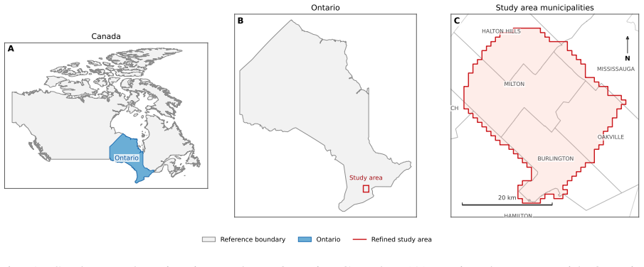
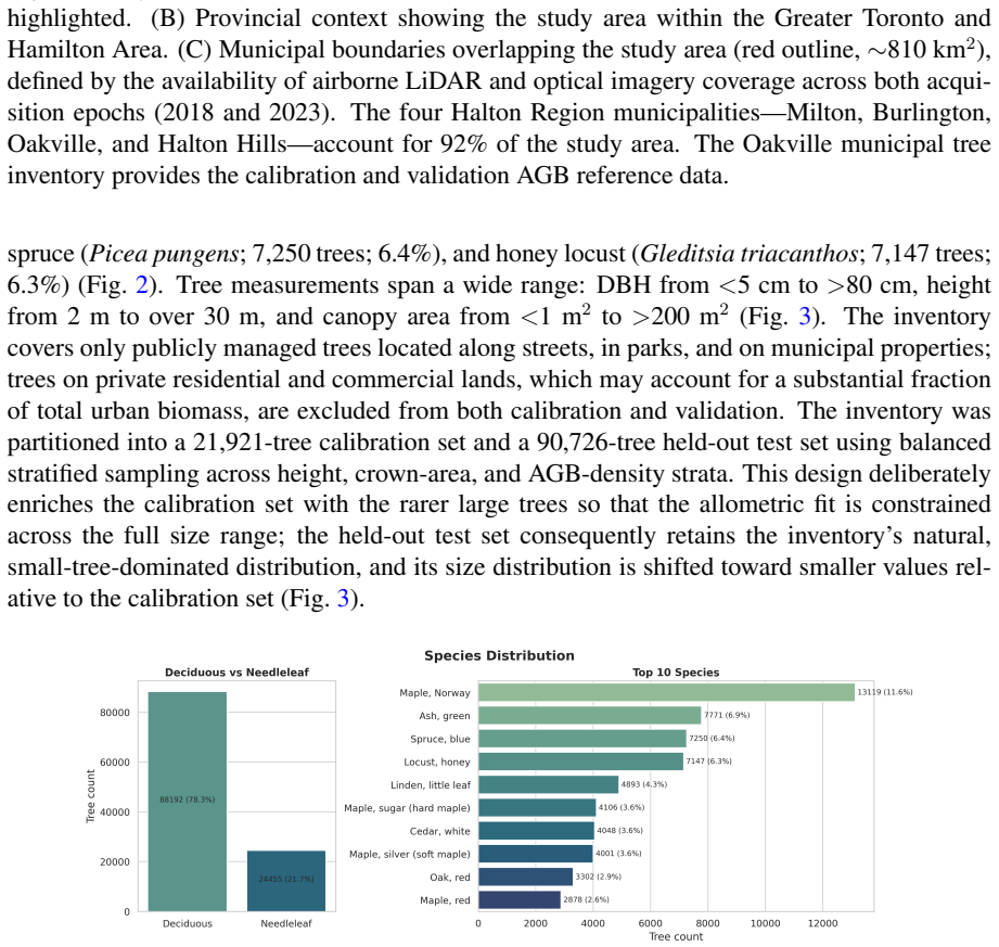
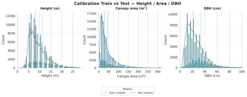
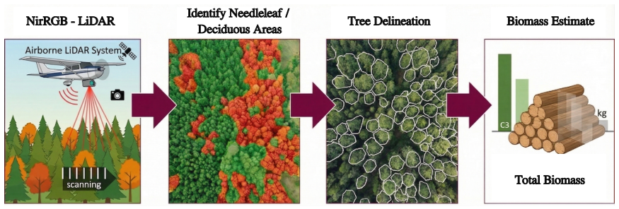
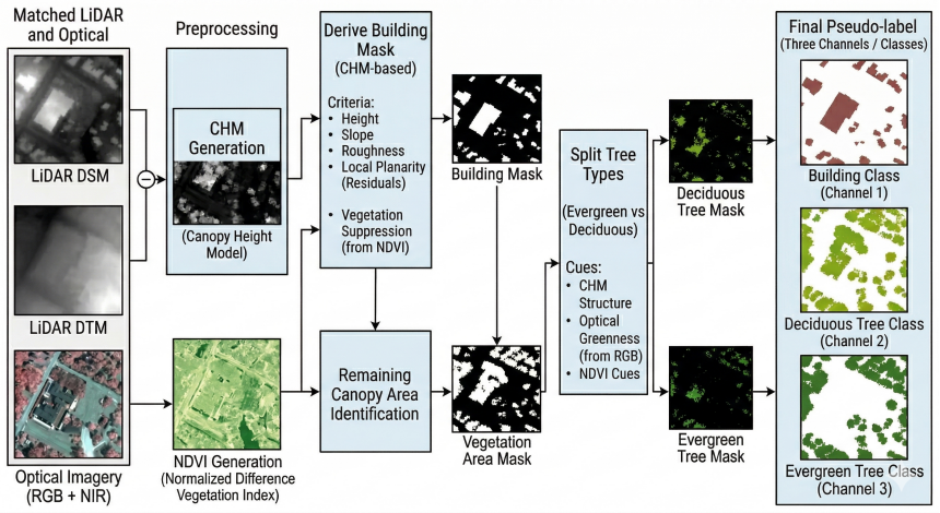
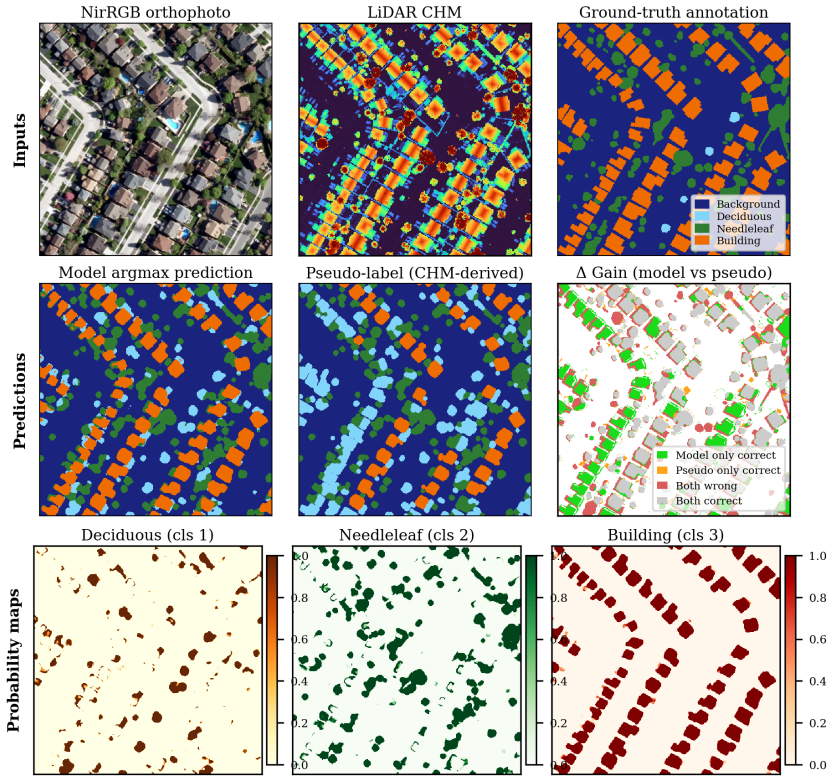
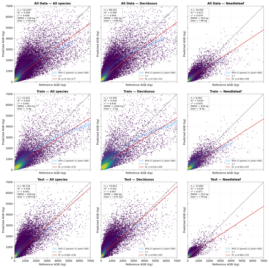
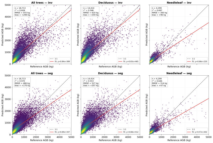
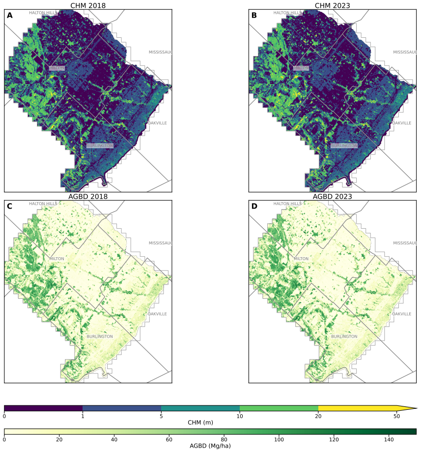
The authors present a crown-level above-ground biomass framework using a dual-stream cross-attention network trained on rule-based pseudo-labels to segment buildings, needleleaf trees, and deciduous trees from 8-10 pulses m⁻² LiDAR and 0.16-0.20 m orthophotography. Crowns are delineated with multiscale watershed segmentation in mapped tree areas, and AGB is estimated from a crown area-height power-law proxy calibrated to species-specific allometry for 21,921 inventory trees. For 18,713 inventory-segment matched pairs from a 90,726-tree held-out test set, AGB prediction achieved R²=0.609 using inventory crown geometry and R²=0.570 under operational segmentation. Aggregated to 30 m, estimates
What carries the argument
Dual-stream cross-attention network trained on rule-based pseudo-labels for semantic segmentation of tree functional types, combined with multiscale watershed segmentation for crown delineation and the crown area-height power-law AGB proxy calibrated to inventory allometry.
If this is right
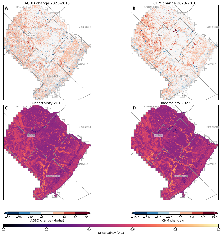
- Aggregated 30 m biomass maps reveal local densities up to ~140 Mg ha⁻¹ and allow tracking of net carbon gains of 39 Gg C between 2018 and 2023.
- Deep-ensemble uncertainty maps identify high-uncertainty zones where a pooled allometric equation should replace species-specific ones.
- The entire pipeline runs on standard provincial airborne data and requires no manual annotation, producing a public bitemporal crown-level AGB database.
- Crown delineation is identified as the dominant remaining uncertainty source limiting AGB accuracy under operational conditions.
Where Pith is reading between the lines
- Closing the gap between the 0.609 inventory R² and the 0.570 operational R² would require only better automatic crown outlines rather than changes to the biomass formula.
- The public crown-level database could be overlaid with other urban layers to examine links between tree biomass and local temperature or air quality.
- The same self-supervised segmentation step could be reused to estimate additional crown attributes such as volume or growth rate from repeated LiDAR acquisitions.
- Testing the framework in cities with different tree species mixes would reveal how far the Lambert et al. (2005) allometric calibration generalizes.
Load-bearing premise
Biomass can be accurately calculated from the area and height of each automatically segmented crown using a power-law relationship fitted to species data from field inventories.
What would settle it
Direct biomass measurements obtained by harvesting and weighing a sample of urban trees would show whether the model predictions match actual values at the reported R² level, especially for operationally segmented crowns.
Figures
read the original abstract
Urban tree biomass remains less spatially explicitly quantified than biomass in managed forests because many estimates rely on inventories or coarse products that cannot resolve individual crowns or fine-scale heterogeneity. We present a crown-level above-ground biomass (AGB) framework for an 810~km$^2$ landscape in Ontario, Canada, using leaf-off airborne LiDAR (8--10~pulses~m$^{-2}$) and near-infrared RGB orthophotography (0.16--0.20~m) from 2018 and 2023. A dual-stream cross-attention network trained on rule-based pseudo-labels produced semantic marks for buildings, needleleaf trees, and deciduous trees, supporting crown delineation and functional-type assignment. On independently annotated withheld tiles, global/mean precision, recall, and Dice scores were 0.86, 0.83, and 0.84. Crowns were delineated with multiscale watershed segmentation in mapped tree areas, and AGB was estimated from a crown area--height power-law proxy calibrated to species-specific allometry (Lambert et al., 2005) for 21,921 inventory trees. For 18,713 inventory--segment matched pairs from a 90,726-tree held-out test set, AGB prediction achieved $R^2=0.609$ using inventory crown geometry and $R^2=0.570$ under operational segmentation, identifying crown delineation as the remaining uncertainty source. Aggregated to 30~m, estimates yielded total AGB stocks of 1.73~Tg in 2018 and 1.81~Tg in 2023 (811--850~Gg~C), local densities up to ${\sim}140$~Mg~ha$^{-1}$ along the Niagara Escarpment, and a net carbon gain of 39~Gg~C over five years. Deep-ensemble uncertainty maps highlighted high-epistemic-uncertainty areas linked to underrepresented land covers and guided assignment of uncertain crowns to a pooled allometric equation. The framework uses standard provincial data, requires no manual annotation, and produces a public bitemporal crown-level AGB database for trees outside forests at management-relevant resolution.
Editorial analysis
A structured set of objections, weighed in public.
Referee Report
Summary. The manuscript proposes a self-supervised pipeline for crown-level above-ground biomass (AGB) estimation in urban settings from airborne LiDAR and RGB imagery over an 810 km² area. It uses a dual-stream cross-attention network trained on rule-based pseudo-labels for semantic segmentation, multiscale watershed segmentation for crown delineation, and a crown area-height power-law proxy calibrated to species-specific allometry (Lambert et al., 2005) on 21,921 inventory trees for AGB prediction. On 18,713 matched pairs from a 90,726-tree held-out test set, it reports R²=0.609 using inventory crown geometry and R²=0.570 under operational segmentation, with aggregated stocks of 1.73 Tg (2018) and 1.81 Tg (2023) at 30 m resolution and a public bitemporal database.
Significance. If the evaluation procedure is clarified, the framework could enable fine-scale, crown-level biomass mapping in urban areas using standard provincial data without manual annotation. Strengths include the self-supervised segmentation, deep-ensemble uncertainty maps, and production of a public database. The reported performance metrics, however, rest on a proxy calibrated to the validation allometry and a matched-pair subset whose representativeness is unspecified.
major comments (3)
- [Abstract] Abstract: The AGB prediction R² values (0.609 on inventory crowns, 0.570 on segmented crowns) are obtained from a crown area-height power-law proxy whose coefficients are calibrated to the same species-specific allometry (Lambert et al., 2005) used to generate the reference AGB values for both the 21,921 calibration trees and the 18,713 test pairs. This setup means the metrics partly measure consistency with the calibration step rather than independent prediction from LiDAR/optical observations.
- [Abstract] Abstract: No matching criteria (e.g., overlap threshold, proximity, or minimum crown size) are stated for selecting the 18,713 inventory-segment pairs from the 90,726-tree held-out set. Without these details, it cannot be determined whether the matched subset is enriched for well-delineated crowns, leaving the performance on the remaining trees (where segmentation error is identified as the primary uncertainty) untested.
- [Abstract] Abstract: The calibration procedure for the power-law coefficients, any sensitivity analysis to the fit, and the handling of functional-type (vs. species-specific) labels for unmatched crowns are not described. These omissions are load-bearing for the claim that crown delineation is the remaining uncertainty source after reporting R²=0.570.
minor comments (1)
- [Abstract] Abstract: The segmentation metrics ('global/mean precision, recall, and Dice scores were 0.86, 0.83, and 0.84') are reported without clarifying whether they are overall or per-class averages, which affects interpretation of the semantic segmentation step.
Simulated Author's Rebuttal
We appreciate the referee's comments on the clarity of our evaluation procedure. We will make revisions to address the omissions noted and provide additional context for the reported metrics.
read point-by-point responses
-
Referee: [Abstract] Abstract: The AGB prediction R² values (0.609 on inventory crowns, 0.570 on segmented crowns) are obtained from a crown area-height power-law proxy whose coefficients are calibrated to the same species-specific allometry (Lambert et al., 2005) used to generate the reference AGB values for both the 21,921 calibration trees and the 18,713 test pairs. This setup means the metrics partly measure consistency with the calibration step rather than independent prediction from LiDAR/optical observations.
Authors: We agree with the observation that the R² metrics evaluate the application of the calibrated proxy to crown geometries rather than an independent machine learning model predicting AGB directly from the input data. The framework is designed to use the proxy as the link from remotely sensed crown attributes to AGB, calibrated on available inventory. The comparison between inventory and segmented crowns specifically isolates the contribution of the segmentation step. We will revise the abstract to clarify this distinction and emphasize that the method enables AGB mapping in the absence of inventory data by applying the proxy to delineated crowns. revision: yes
-
Referee: [Abstract] Abstract: No matching criteria (e.g., overlap threshold, proximity, or minimum crown size) are stated for selecting the 18,713 inventory-segment pairs from the 90,726-tree held-out set. Without these details, it cannot be determined whether the matched subset is enriched for well-delineated crowns, leaving the performance on the remaining trees (where segmentation error is identified as the primary uncertainty) untested.
Authors: The referee is correct that the matching criteria are not described in the current manuscript. We will add a detailed description of how the 18,713 matched pairs were selected, including any overlap thresholds or size criteria used. This will also include a discussion of potential selection bias and how the uncertainty quantification addresses performance across the full set of trees. revision: yes
-
Referee: [Abstract] Abstract: The calibration procedure for the power-law coefficients, any sensitivity analysis to the fit, and the handling of functional-type (vs. species-specific) labels for unmatched crowns are not described. These omissions are load-bearing for the claim that crown delineation is the remaining uncertainty source after reporting R²=0.570.
Authors: We acknowledge that the calibration procedure, sensitivity analysis, and handling of unmatched crowns require more detailed description. We will expand the methods section to include these elements, which will strengthen the support for identifying crown delineation as the primary uncertainty source. This revision will provide the necessary transparency for the evaluation. revision: yes
Circularity Check
No significant circularity detected
full rationale
The AGB proxy is a power-law fitted on a distinct calibration set of 21,921 trees using external Lambert et al. (2005) allometry, then evaluated on a held-out test set of 18,713 matched pairs drawn from a separate 90,726-tree pool. The reported R² values therefore measure out-of-sample approximation quality rather than reproducing calibration inputs by construction. Semantic segmentation relies on rule-based pseudo-labels and multiscale watershed operates on the resulting maps; neither step reduces to the biomass calibration. No self-citation chains, uniqueness theorems, or ansatz smuggling appear in the load-bearing steps.
Axiom & Free-Parameter Ledger
free parameters (1)
- power-law coefficients in AGB proxy
axioms (2)
- domain assumption Rule-based pseudo-labels accurately capture semantic classes of buildings, needleleaf trees, and deciduous trees
- domain assumption Lambert et al. (2005) allometric equations apply to the urban trees in the Ontario study area
Reference graph
Works this paper leans on
-
[1]
Ontario Imagery Program (South Central Ontario Orthophotography Project — SCOOP) , year =
-
[2]
Ontario Elevation Mapping Program (OEMP) , year =
-
[3]
2022 , address =
Federal Airborne LiDAR Data Acquisition Guideline, Version 3.1 , institution =. 2022 , address =
2022
-
[4]
Municipal Tree Inventory , year =
-
[5]
Canadian national tree aboveground biomass equations , journal =
Lambert, Marie-Claude and Ung, Chhun-Huor and Raulier, Fr. Canadian national tree aboveground biomass equations , journal =. 2005 , volume =
2005
-
[6]
Allometric equations for integrating remote sensing imagery into forest monitoring programmes , journal =
Jucker, Tommaso and Caspersen, John and Chave, J. Allometric equations for integrating remote sensing imagery into forest monitoring programmes , journal =. 2017 , volume =
2017
-
[7]
, title =
Baskerville, Gordon L. , title =. Canadian Journal of Forest Research , year =
-
[8]
Journal of the American Statistical Association , year =
Duan, Naihua , title =. Journal of the American Statistical Association , year =
-
[9]
PLOS ONE , year =
Liu, Xinyi and Dong, Lili and Li, Shitong and Li, Zhaoyi and Wang, Yingxin and Mao, Zeqing and others , title =. PLOS ONE , year =
-
[10]
Figueiredo, Evandro J. A. and dos Santos, Daniel R. and Ferrari, Felipe and others , title =. Urban Forestry & Urban Greening , year =
-
[11]
Frontiers in Remote Sensing , year =
Wang, Xiaoyu and Chen, Jian and Zhang, Wei and others , title =. Frontiers in Remote Sensing , year =
-
[12]
Urban Forestry & Urban Greening , year =
Aguilar, Emilio and Vallejo, Gonzalo , title =. Urban Forestry & Urban Greening , year =
-
[13]
PLOS ONE , year =
Fischer, Rico and Ensslin, Andreas and Rutten, Gemma and others , title =. PLOS ONE , year =
-
[14]
Advances in Neural Information Processing Systems (NeurIPS) , year =
Lakshminarayanan, Balaji and Pritzel, Alexander and Blundell, Charles , title =. Advances in Neural Information Processing Systems (NeurIPS) , year =
-
[15]
Advances in Neural Information Processing Systems (NeurIPS) , year =
Kendall, Alex and Gal, Yarin , title =. Advances in Neural Information Processing Systems (NeurIPS) , year =
-
[16]
, title =
Guo, Chuan and Pleiss, Geoff and Sun, Yu and Weinberger, Kilian Q. , title =. Proceedings of the 34th International Conference on Machine Learning (ICML) , year =
-
[17]
Advances in Neural Information Processing Systems (NeurIPS) , year =
Ovadia, Yaniv and Fertig, Emily and Ren, Jie and others , title =. Advances in Neural Information Processing Systems (NeurIPS) , year =
-
[18]
and Danelljan, Martin and Schon, Thomas B
Gustafsson, Fredrik K. and Danelljan, Martin and Schon, Thomas B. , title =. Proceedings of the IEEE/CVF Conference on Computer Vision and Pattern Recognition Workshops (CVPRW) , year =
-
[19]
Decomposition of Uncertainty in
Depeweg, Stefan and Hern. Decomposition of Uncertainty in. Proceedings of the 35th International Conference on Machine Learning (ICML) , year =
-
[20]
Masked Autoencoders Are Scalable Vision Learners , journal =
He, Kaiming and Chen, Xinlei and Xie, Saining and Li, Yanghao and Doll. Masked Autoencoders Are Scalable Vision Learners , journal =. 2022 , pages =
2022
-
[21]
and Gupta, Agrim and Li, Shoaib and others , title =
Reed, Connor J. and Gupta, Agrim and Li, Shoaib and others , title =. Proceedings of the IEEE/ICCV , year =
-
[22]
Nature Communications , year =
Tuia, Devis and Kellenberger, Benjamin and Beery, Sara and others , title =. Nature Communications , year =
-
[23]
Proceedings of the IEEE/CVF International Conference on Computer Vision (ICCV) , year =
Howard, Andrew and Sandler, Mark and Chu, Grace and others , title =. Proceedings of the IEEE/CVF International Conference on Computer Vision (ICCV) , year =
-
[24]
Proceedings of the IEEE/CVF Conference on Computer Vision and Pattern Recognition (CVPR) , year =
Szegedy, Christian and Vanhoucke, Vincent and Ioffe, Sergey and Shlens, Jon and Wojna, Zbigniew , title =. Proceedings of the IEEE/CVF Conference on Computer Vision and Pattern Recognition (CVPR) , year =
-
[25]
and Marconi, Sergio and Bohlman, Stephanie and Zare, Alina and White, Ethan , title =
Weinstein, Ben G. and Marconi, Sergio and Bohlman, Stephanie and Zare, Alina and White, Ethan , title =. Remote Sensing , year =
-
[26]
Ball, James G. C. and Hickman, Sebastian H. M. and Jackson, Tobias D. and Korat, Xian J. and Sherwood, Sruthi C. and Coomes, David A. , title =. Remote Sensing in Ecology and Conservation , year =
-
[27]
Proceedings of the IEEE/CVF International Conference on Computer Vision (ICCV) , year =
Kirillov, Alexander and Mintun, Eric and Ravi, Nikhila and others , title =. Proceedings of the IEEE/CVF International Conference on Computer Vision (ICCV) , year =
-
[28]
and Wynne, Randolph H
Popescu, Sorin C. and Wynne, Randolph H. and Nelson, Ross F. , title =. Canadian Journal of Remote Sensing , year =
-
[29]
Brent , title =
Naveed, Faizaan and Hu, Baoxin and Wang, Jianguo and Hall, G. Brent , title =. Sensors , year =
-
[30]
Remote Sensing , year =
Yang, Jian and Jones, Taryn and Caspersen, John and He, Yuhong , title =. Remote Sensing , year =
-
[31]
and Gaulton, Rachel , title =
Berra, Elias F. and Gaulton, Rachel , title =. International Journal of Remote Sensing , year =
-
[32]
and Coops, Nicholas C
Nuijten, Renee J.G. and Coops, Nicholas C. and Goodbody, Tristan R.H. and Pelletier, Gaetan , title =. Remote Sensing , year =
-
[33]
Forests , year =
Dietenberger, Sebastian and Berger, Christian and Siegmann, Bastian and others , title =. Forests , year =
-
[34]
and Vepakomma, Udayalakshmi and others , title =
Vandendaele, Bastien and Fournier, Richard A. and Vepakomma, Udayalakshmi and others , title =. Remote Sensing , year =
-
[35]
ISPRS Journal of Photogrammetry and Remote Sensing , year =
Dersch, Sebastian and Heurich, Marco and Krueger, Norbert and Krzystek, Peter , title =. ISPRS Journal of Photogrammetry and Remote Sensing , year =
-
[36]
Remote Sensing , year =
Benciolini, Battista and Toth, Charles and Vettore, Antonio , title =. Remote Sensing , year =
-
[37]
Individual tree crown detection and delineation in mixed temperate forest using airborne
Eker, Remzi and Ay. Individual tree crown detection and delineation in mixed temperate forest using airborne. Remote Sensing , year =
-
[38]
Remote Sensing of Environment , year =
Ahmed, Rafi and Siqueira, Paul and Hensley, Scott , title =. Remote Sensing of Environment , year =. doi:10.1016/j.rse.2012.11.015 , note =
-
[39]
and Smith, Thomas E
Simpson, Jonathan E. and Smith, Thomas E. L. and Wooster, Martin J. , title =. Remote Sensing , year =
-
[40]
Chen, Qi and Vaglio Laurin, Gaia and Battles, John J. and Saah, David , title =. Remote Sensing of Environment , year =. doi:10.1016/j.rse.2012.01.021 , note =
-
[41]
and Saenz, Eraldo and Montesano, Paul M
Cushman, Kelsey C. and Saenz, Eraldo and Montesano, Paul M. and others , title =. Agricultural and Forest Meteorology , year =
-
[42]
Remote Sensing of Environment , year =
Rajab Pourrahmati, Mehrdad and Baghdadi, Nicolas and Darvishzadeh, Roshanak and Ziaee, Hooman , title =. Remote Sensing of Environment , year =
-
[43]
and Carboni, Elisa and Burt, Andrew and others , title =
Boyd, Doreen S. and Carboni, Elisa and Burt, Andrew and others , title =. Remote Sensing of Environment , year =
-
[44]
and Goodbody, Tristan R
Chadwick, Arthur J. and Goodbody, Tristan R. H. and Coops, Nicholas C. and others , title =. Agricultural and Forest Meteorology , year =
-
[45]
Song, Xiao-Peng and Hansen, Matthew C. and Stehman, Stephen V. and others , title =. Nature , year =. doi:10.1038/s41586-018-0411-9 , note =
-
[46]
IEEE Geoscience and Remote Sensing Magazine , year =
Liang, Xinlian and Kukko, Antero and Kaartinen, Harri and others , title =. IEEE Geoscience and Remote Sensing Magazine , year =
-
[47]
, title =
Zenonos, Alexandros and Ioannidis, Chrysostomos and Grigoriadis, Vassilios N. , title =. Remote Sensing , year =
-
[48]
Science of Remote Sensing , year =
Dubayah, Ralph and Blair, James Bryan and Goetz, Scott and others , title =. Science of Remote Sensing , year =
-
[49]
Urban Forestry & Urban Greening , year =
Ma, Chunyuan and Zhao, Jingxia and Zheng, Zhaoju and others , title =. Urban Forestry & Urban Greening , year =
-
[50]
Remote Sensing , year =
Lian, Xi and Zhang, Hua and Xiao, Wenfa and others , title =. Remote Sensing , year =
-
[51]
Remote Sensing , year =
Khan, Mohd Rihan and Gupta, Ayan and Kumar, Amit and others , title =. Remote Sensing , year =
-
[52]
Remote Sensing , year =
Lyu, Xinyu and Li, Xiliang and Dang, Dongliang and others , title =. Remote Sensing , year =
-
[53]
Remote Sensing , year =
So, Yan and Zhong, Zilong and Cyr, Dominic and Gonsamo, Alemu and Bermudez, Jose , title =. Remote Sensing , year =
-
[54]
Carbon Balance and Management , year =
Hadush, Hagos and Zewdie, Woldeamlak , title =. Carbon Balance and Management , year =
-
[55]
and Raja Segaran, Raja Rizal and Clarke, Kevin D
Jones, Andrew R. and Raja Segaran, Raja Rizal and Clarke, Kevin D. and others , title =. Frontiers in Marine Science , year =
-
[56]
and Bahn, Volker and Ciuti, Simone and others , title =
Roberts, David R. and Bahn, Volker and Ciuti, Simone and others , title =. Ecography , year =
-
[57]
ISPRS Journal of Photogrammetry and Remote Sensing , year =
Kolanuvada, Sai Rohit and Pham, Trung Hieu and Nguyen, Anh Duc , title =. ISPRS Journal of Photogrammetry and Remote Sensing , year =
-
[58]
and Danylo, Olha and others , title =
Weber, Henri and Gella, Geert W. and Danylo, Olha and others , title =. Geospatial Foundation Models , year =
-
[59]
International Journal of Applied Earth Observation and Geoinformation , year =
Michelini, Lorenzo and Mura, Matteo and Miozzo, Marcello , title =. International Journal of Applied Earth Observation and Geoinformation , year =
-
[60]
and Dubayah, Ralph O
Duncanson, Laura I. and Dubayah, Ralph O. and Cook, Bruce D. and Rosette, Jacqueline and Parker, Geoffrey , title =. Remote Sensing of Environment , year =
-
[61]
and Nemmaoui, Abderrahim and Aguilar, Manuel A
Aguilar, Francisco J. and Nemmaoui, Abderrahim and Aguilar, Manuel A. and others , title =. Computers and Electronics in Agriculture , year =
-
[62]
Proceedings of the IEEE/CVF Conference on Computer Vision and Pattern Recognition (CVPR) , year =
Woo, Sanghyun and Debnath, Shoubhik and Hu, Ronghang and Chen, Xinlei and Liu, Zhuang and Kweon, In So and Xie, Saining , title =. Proceedings of the IEEE/CVF Conference on Computer Vision and Pattern Recognition (CVPR) , year =
-
[63]
Proceedings of the IEEE/CVF Conference on Computer Vision and Pattern Recognition (CVPR) , year =
Liu, Zhuang and Mao, Hanzi and Wu, Chao-Yuan and Feichtenhofer, Christoph and Darrell, Trevor and Xie, Saining , title =. Proceedings of the IEEE/CVF Conference on Computer Vision and Pattern Recognition (CVPR) , year =
-
[64]
Medical Image Computing and Computer-Assisted Intervention (MICCAI) , year =
Ronneberger, Olaf and Fischer, Philipp and Brox, Thomas , title =. Medical Image Computing and Computer-Assisted Intervention (MICCAI) , year =
-
[65]
and Kaiser,
Vaswani, Ashish and Shazeer, Noam and Parmar, Niki and Uszkoreit, Jakob and Jones, Llion and Gomez, Aidan N. and Kaiser,. Attention Is All You Need , booktitle =. 2017 , volume =
2017
-
[66]
International Conference on Learning Representations (ICLR) , year =
Loshchilov, Ilya and Hutter, Frank , title =. International Conference on Learning Representations (ICLR) , year =
-
[67]
Signal Processing , year =
Meyer, Fernand , title =. Signal Processing , year =
-
[68]
He, Kaiming and Gkioxari, Georgia and Doll. Mask. Proceedings of the IEEE International Conference on Computer Vision (ICCV) , year =
-
[69]
European Conference on Computer Vision (ECCV) , year =
Carion, Nicolas and Massa, Francisco and Synnaeve, Gabriel and Usunier, Nicolas and Kirillov, Alexander and Zagoruyko, Sergey , title =. European Conference on Computer Vision (ECCV) , year =
-
[70]
and Waldner, Fran
Diakogiannis, Foivos I. and Waldner, Fran. ISPRS Journal of Photogrammetry and Remote Sensing , year =
-
[71]
Technometrics , volume=
Note on a method for calculating corrected sums of squares and products , author=. Technometrics , volume=. 1962 , publisher=
1962
-
[72]
1999 , publisher=
Morphological image analysis: principles and applications , author=. 1999 , publisher=
1999
-
[73]
Annual review of entomology , volume=
Emerald ash borer invasion of North America: history, biology, ecology, impacts, and management , author=. Annual review of entomology , volume=. 2014 , publisher=
2014
-
[74]
Forests , volume=
Carbon content of tree tissues: a synthesis , author=. Forests , volume=. 2012 , publisher=
2012
-
[75]
Urban forestry & urban greening , volume=
Air pollution removal by urban trees and shrubs in the United States , author=. Urban forestry & urban greening , volume=. 2006 , publisher=
2006
-
[76]
Urban tree database and allometric equations , author=. Gen. Tech. Rep. PSW-GTR-253. Albany, CA: US Department of Agriculture, Forest Service, Pacific Southwest Research Station. 86 p. , volume=
-
[77]
Remote Sensing of Environment , volume=
Red and photographic infrared linear combinations for monitoring vegetation , author=. Remote Sensing of Environment , volume=. 1979 , publisher=
1979
-
[78]
2026 , type =
National Inventory Report: Greenhouse Gas Sources and Sinks in Canada , institution =. 2026 , type =
2026
-
[79]
and Sobie, Stephen R
Cannon, Alex J. and Sobie, Stephen R. and Murdock, Trevor Q. , title =. Journal of Climate , year =
-
[80]
Empirical-statistical downscaling and error correction of regional climate models and its impact on the climate change signal , journal =
Theme. Empirical-statistical downscaling and error correction of regional climate models and its impact on the climate change signal , journal =. 2012 , volume =
2012
discussion (0)
Sign in with ORCID, Apple, or X to comment. Anyone can read and Pith papers without signing in.