REVIEW 5 major objections 5 minor 28 references
Rapid Distributed Fine-tuning of a Segmentation Model Onboard Satellites
T0 review · 5 major / 5 minor · reviewed 2026-08-12 · deepseek-v4-flash
Pith's one-line read In-orbit retraining lifts flood-map accuracy from 0.47 to 0.69 IoU
desk verdict A credible proof-of-concept for onboard MobileSAM fine-tuning with open code, but the 'benefits from decentralised learning' claim lacks a no-communication baseline. read the letter →
The pith
A machine-rendered reading of the paper's core claim, the machinery that carries it, and where it could break.
The reading
What carries the argument
The load-bearing object is MobileSAM, a lightweight segmentation model with 5.78 million parameters in its image encoder, about 60 times smaller than the original Segment Anything encoder, paired with the same mask decoder; the paper freezes the encoder and fine-tunes only the decoder. The distributed training loop is the second piece: each satellite trains on its own local tiles, and when a communication window opens the satellites exchange model weights rather than raw imagery, with scenario 1 using three ground stations and scenario 2 using a geostationary relay satellite. An orbital operations simulator couples these activities to battery state of charge and hardware temperature, forcing satellites into standby below 0.2 state of charge or above 40 degrees Celsius, so the reported convergence times include realistic operational interruptions.
What would settle it
Run the same fine-tuning loop continuously on the actual satellite processor for a full day under realistic orbital lighting, logging temperature and battery state; if the hardware throttles, overheats, or drains faster than the simulator predicts, the feasibility claim under operational constraints would have to be revised.
Extended reading notes
Core claim
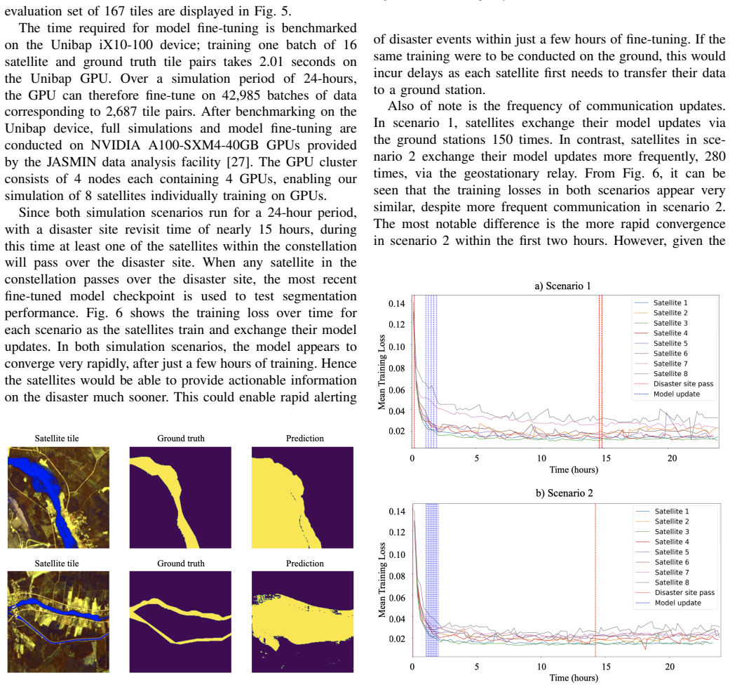
The central claim, stated on the paper's own terms, is that MobileSAM can be rapidly fine-tuned onboard satellite hardware and that decentralised learning within a constellation improves that fine-tuning under simulated orbital constraints. The evidence is a controlled comparison: eight satellites each train on a private partition of 1,840 flood tiles, exchange model weights through ground stations (scenario 1) or a geostationary relay (scenario 2), and pause when battery or temperature limits are hit. The fine-tuned model lifts IoU from 0.47 to 0.69 in scenario 2 and to about 0.64 in scenario 1 at the Ylitornio disaster site, and the training loss converges within a few hours in both scenarios. The authors also benchmark one training batch on a radiation-tolerant satellite processor, reporting 2.01 seconds per batch of 16 image-mask pairs.
Load-bearing premise
The load-bearing premise is that labelled flood masks are already available on the satellites when fine-tuning begins; without stored or in-orbit-generated labels, the training loop has no signal to learn from.
Editorial extensions
If this is right
- Fine-tuning needs very little labelled data: the entire processed training set is 1.3 GB (1,840 tile pairs), small enough to be stored and used onboard.
- In both simulated scenarios the model converges within a few hours, meaning a useful flood map could be produced before the next ground-station contact.
- More frequent communication through the relay satellite speeds up convergence in the first two hours, but final performance is similar to the ground-station scenario, so the relay's extra cost must be justified by time saved.
- Since only the mask decoder is retrained, the same procedure can be repeated for new disaster sites or other hazards without retraining the full model.
- Where ground truth labels are imperfect, the fine-tuned predictions can even look better than the labels, so reported IoU should be read as a lower bound on true map quality.
Reading between the lines
- The single-batch hardware benchmark leaves sustained-operation behaviour unmeasured; a real multi-orbit run could show thermal or power limits that the simulation only approximates.
- If the gain transfers to other disasters, the main remaining bottleneck is labels in orbit, so self-supervised pretraining on raw, unlabelled imagery is the natural next step rather than collecting more labelled data.
- The similar final IoU under very different communication frequencies hints that update frequency saturates quickly; if so, constellations could conserve bandwidth by exchanging weights only at rare, predictable windows.
- The improvement is measured at one held-out flood site; repeating the protocol across several disaster sites would test whether the 0.47-to-0.69 jump is robust or site-specific.
Editorial analysis
A structured set of objections, weighed in public.
Referee Report
Summary. The paper presents a proof-of-concept for fine-tuning MobileSAM on satellite hardware for flood segmentation, using the WorldFloods dataset and the PASEOS orbital-simulation framework. The authors benchmark one training batch on a Unibap iX10-100 processor, then simulate an 8-satellite constellation fine-tuning the mask decoder over 24 hours under two communication scenarios (ground-station relaying and EDRS relay). They report an improvement in IoU at a held-out flood site from 0.47 before fine-tuning to 0.64 (scenario 1) and 0.69 (scenario 2), and argue that MobileSAM can be rapidly fine-tuned and benefits from decentralised learning under operational constraints.
Significance. If the claims hold, the work is a useful proof-of-concept for onboard fine-tuning of lightweight foundation models in Earth observation, with potential relevance to disaster response. The paper's strengths include releasing code for data processing, modelling, and simulation; integrating MobileSAM with PASEOS; and reporting per-batch timing on actual satellite hardware. However, the evidence for the decentralised-learning benefit is incomplete, and several quantitative claims are based on a single run with a very small test set. The paper is therefore a reasonable engineering demonstration, but its central interpretive claim needs additional experiments or careful rephrasing.
major comments (5)
- [Abstract; Section III (Results); Section IV (Concluding Remarks)] The central claim that MobileSAM 'benefits from decentralised learning' is not directly supported by the experiments. In both simulation scenarios every satellite exchanges model updates (150 exchanges via ground stations in scenario 1, 280 via EDRS in scenario 2), and there is no control configuration in which satellites train solely on their local data and never communicate. Figure 6 therefore demonstrates that two communication-enabled configurations converge quickly, but it does not measure the marginal benefit of communication. A zero-communication baseline under matched orbital parameters is required before the abstract and concluding remarks can claim a benefit from decentralised learning.
- [Section III (Results) and Section IV] The fine-tuning experiments were run on NVIDIA A100 GPUs at JASMIN; the Unibap iX10-100 was used only to benchmark a single batch of 16 tile pairs (2.01 s). Statements such as 'MobileSAM can effectively be fine-tuned onboard satellite hardware' (Section IV) therefore exceed the evidence. Please either perform the full fine-tuning on the Unibap device or rephrase the claims so that the on-device evidence is limited to the measured per-batch cost, with end-to-end training described as simulated on ground GPUs.
- [Table I; Section III (Results); Figure 6] The comparison between scenarios 1 and 2 is confounded: the scenarios differ simultaneously in communication infrastructure (ground stations vs EDRS), altitude (786 vs 450 km), inclination (98.6 vs 97.4 degrees), and orbits per day (14.3 vs 15.4). Consequently the faster early convergence in scenario 2 cannot be attributed to the larger number of exchange events (280 vs 150). The orbital parameters should be held fixed when varying communication frequency.
- [Section III (Results); Figure 8] All reported IoU values, including the headline improvement from 0.47 to 0.69/0.64, come from a single run evaluated on 17 test tiles from one flood site (Ylitornio) and are presented without error bars, confidence intervals, or multiple seeds. Given the small evaluation set, the improvement could lie within run-to-run variability; please report variance over repeated fine-tuning runs and, if possible, results on additional disaster sites.
- [Section III (Results)] The throughput calculation contains an arithmetic inconsistency: 42,985 batches per day at 16 tile pairs per batch corresponds to approximately 687,800 tile pairs per day, not the stated 2,687. The value 2,687 appears to result from dividing 42,985 by 16 rather than multiplying. Since this number is used to support the 'rapid fine-tuning' claim, please correct the calculation and re-derive any conclusions that depend on it.
minor comments (5)
- [Section II-B] The sentence 'We identify the optimal configuration by maximising training and validation losses' presumably should read 'minimising' rather than 'maximising'.
- [Section II-A] The paper does not report how many of the 1,840 training tile-pairs were used for validation during hyperparameter selection, nor any validation metrics; adding this information would make the hyperparameter choices more reproducible.
- [Figure 5] The caption says 'Cumulative frequency of IoU values for a satellite from each scenario', but the text and plot appear to combine results across satellites; please clarify what is aggregated.
- [References] References [23] and [28] are the same Thales Group item and should be merged.
- [Section I-C] The contribution 'We demonstrate for the first time use of a SAM model onboard satellite hardware' is stronger than the evidence warrants, since the full model was not trained onboard; suggesting 'to our knowledge' and clarifying the exact scope would be more precise.
Circularity Check
No significant circularity: the reported IoU gains are measured outcomes of an empirical fine-tuning pipeline, not quantities that reduce to fitted inputs or self-citation.
full rationale
The paper's derivation chain is empirical and self-contained. No parameter is fitted to the reported outcome and then renamed a prediction; the IoU figures (0.47 before fine-tuning, 0.69 for scenario 2, and about 0.64 for scenario 1) are measured on held-out Ylitornio disaster-site tiles after training on WorldFloods tiles, with hyperparameters selected by training and validation loss (Section II-B) rather than by test-set performance. The PASEOS simulations supply operational constraints (power, temperature, communication windows) as exogenous inputs, not as functions of the segmentation results. Self-citations ([6], [7], [17]) are used as prior work, tools, or comparison points and are not load-bearing in the sense of predetermining or defining the reported convergence behavior. The stated assumption that labelled training samples are already available onboard is a transparency limitation, not a circular input. The skeptical concern that the 'benefits from decentralised learning' claim is under-supported because no zero-communication baseline is reported is an external-validity gap, not a circularity: the absence of a control does not make the measured improvement equivalent to its inputs. Therefore no circular steps are identified.
Assumptions & free parameters
free parameters (7)
- learning_rate =
1e-5
- batch_size =
16
- loss_function =
MSE
- state_of_charge_threshold =
0.2
- temperature_threshold =
40 degrees C
- downlink_speed =
10 Mbit/s
- data_split =
1840 tiles split equally among 8 satellites
assumptions (4)
- domain assumption Labelled training samples are already available onboard the satellites.
- domain assumption PASEOS accurately captures power, thermal, and communication constraints of the satellites.
- domain assumption WorldFloods ground truth masks are sufficiently accurate for training and evaluation.
- domain assumption Sentinel-2 L1C data approximates onboard-acquired data.
Cite this review
Pith. "Pith review of Rapid Distributed Fine-tuning of a Segmentation Model Onboard Satellites." pith.science (2026). https://pith.science/paper/F57VFXU4
@misc{pith2026241117831,
  author       = {Pith},
  title        = {Pith review of: Rapid Distributed Fine-tuning of a Segmentation Model Onboard Satellites},
  year         = {2026},
  howpublished = {\url{https://pith.science/paper/F57VFXU4}},
  note         = {Machine review of arXiv:2411.17831}
}
read the original abstract
Segmentation of Earth observation (EO) satellite data is critical for natural hazard analysis and disaster response. However, processing EO data at ground stations introduces delays due to data transmission bottlenecks and communication windows. Using segmentation models capable of near-real-time data analysis onboard satellites can therefore improve response times. This study presents a proof-of-concept using MobileSAM, a lightweight, pre-trained segmentation model, onboard Unibap iX10-100 satellite hardware. We demonstrate the segmentation of water bodies from Sentinel-2 satellite imagery and integrate MobileSAM with PASEOS, an open-source Python module that simulates satellite operations. This integration allows us to evaluate MobileSAM's performance under simulated conditions of a satellite constellation. Our research investigates the potential of fine-tuning MobileSAM in a decentralised way onboard multiple satellites in rapid response to a disaster. Our findings show that MobileSAM can be rapidly fine-tuned and benefits from decentralised learning, considering the constraints imposed by the simulated orbital environment. We observe improvements in segmentation performance with minimal training data and fast fine-tuning when satellites frequently communicate model updates. This study contributes to the field of onboard AI by emphasising the benefits of decentralised learning and fine-tuning pre-trained models for rapid response scenarios. Our work builds on recent related research at a critical time; as extreme weather events increase in frequency and magnitude, rapid response with onboard data analysis is essential.
Figures


Figures from the paper (4 more)



Reference graph
Works this paper leans on
-
[1]
Novaspace, ”Earth Observation Satellite Systems”, Euroconsult Digital platform, Available at: https://digital-platform.euroconsult-ec.com/ product/earth-observation-satellite-systems-database/ (Accessed: 22 July 2024)
work page 2024
- [2]
-
[3]
Kothari, V ., Liberis, E. and Lane, N.D., ”The Final Frontier: Deep Learning in Space,” Proceedings of the 21st International Workshop on Mobile Computing Systems and Applications. , Mar. 2020
work page 2020
-
[4]
Φ-sats programme: Φ-Lab, ” Φ-sats programme”, European Space Agency, Available at: https://philab.esa.int/flagship-programmes/ phi-sats-programme/ (Accessed: 22 July 2024)
work page 2024
-
[5]
R ˚uˇziˇcka, V . Gonzalo Mateo-Garc´ıa, C. Bridges, C. Brunskill, C. Purcell, N. Long ´ep´e, et al., ”Fast model inference and training on-board of Satellites”, IGARSS 2023 - 2023 IEEE International Geoscience and Remote Sensing Symposium [Preprint] , 2023
work page 2023
-
[6]
P. G ´omez and G. Meoni, ”Tackling the Satellite Downlink Bottleneck with Federated Onboard Learning of Image Compression,” in Proceed- ings of the IEEE/CVF Conference on Computer Vision and Pattern Recognition (in press) , 2024
work page 2024
-
[7]
J. ¨Ostman, P. G ´omez, V . M. Shreenath, and G. Meoni, ”Decentralised semi-supervised onboard learning for scene classification in low-earth orbit,” arXiv preprint arXiv:2305.04059 , 2023
arXiv 2023
-
[8]
Matthiesen, B., Razmi, N., Leyva-Mayorga, I., Dekorsy, A. and Popovski, P. ”Federated Learning in Satellite Constellations” IEEE Network, pp.1–16., 2023
work page 2023
Show all 28 references
-
[9]
Bagwari, S
N. Bagwari, S. Kumar, and V . S. Verma, ”A comprehensive review on segmentation techniques for satellite images,”Archives of Computational Methods in Engineering , vol. 30, no. 7, pp. 4325-4358, 2023
2023
-
[10]
Meoni, M
G. Meoni, M. M ¨artens, D. Derksen, K. See, T. Lightheart, A. S ´echer, et al., ”The OPS-SAT case: A data-centric competition for onboard satellite image classification,” Astrodynamics, vol. 2522-0098, Mar. 2024
2024
-
[11]
Mateo-Garcia, J
G. Mateo-Garcia, J. Veitch-Michaelis, L. Smith, S. V . Oprea, G. Schu- mann, Y . Gal, et al., ”Towards global flood mapping onboard low cost satellites with machine learning,” Scientific Reports, vol. 11, no. 1, 2021
2021
-
[12]
Giuffrida, L
G. Giuffrida, L. Fanucci, G. Meoni, M. Bati ˇc, L. Buckley, A. Dunne, et al., ”The Φ-Sat-1 Mission: The First On-Board Deep Neural Network Demonstrator for Satellite Earth Observation,” IEEE Transactions on Geoscience and Remote Sensing , vol. 60, pp. 1-14, 2022
2022
-
[13]
Sebastianelli, M
A. Sebastianelli, M. P. Del Rosso, and S. L. Ullo, ”Automatic dataset builder for machine learning applications to satellite imagery,” Soft- wareX, vol. 15, p. 100739, 2021
2021
-
[14]
Kirillov, E
A. Kirillov, E. Mintun, N. Ravi, H. Mao, C. Rolland, L. Gustafson, et al., ”Segment anything,” arXiv.org, 2023
2023
-
[15]
L. P. Osco, Q. Wu, E. L. de Lemos, W. N. Gonc ¸alves, A. P. M. Ramos, J. Li, et al., ”The segment anything model (Sam) for remote sensing applications: From zero to one shot,” arXiv.org, 2023
2023
-
[16]
Zhang, D
C. Zhang, D. Han, Y . Qiao, J. U. Kim, S.-H. Bae, S. Lee, et al., ”Faster segment anything: Towards lightweight sam for mobile applications,” arXiv.org, 2023
2023
-
[17]
G ´omez, J
P. G ´omez, J. ¨Ostman, V . M. Shreenath, and G. Meoni, ”Paseos simulates the environment for operating multiple spacecraft,” arXiv.org, 2023
2023
-
[18]
Datasets at Hugging Face., ”ISP-UV-es/worldfloodsv2,” Hugging Face,
-
[19]
Portal ´es-Juli`a, G
E. Portal ´es-Juli`a, G. Mateo-Garc ´ıa, C. Purcell, and L. G ´omez-Chova, ”Global flood extent segmentation in optical satellite images,” Scientific Reports, vol. 13, no. 1, pp. 20316, Nov. 2023
2023
-
[20]
Available: https://unibap.com/solutions/ spacecloud-hardware/ix10/
Unibap, ”SpaceCloud® IX10-100 solution,” Unibap SpaceCloud Hardware, [Online]. Available: https://unibap.com/solutions/ spacecloud-hardware/ix10/
-
[21]
[Online]
European Space Agency, ”Sentinel-2 operations”, ESA, no date. [Online]. Available: https://www.esa.int/Enabling Support/Operations/ Sentinel-2 operations (Accessed: 22 July 2024)
2024
-
[22]
European Space Agency, ”European Data Relay Satellite System (EDRS) overview”, ESA CSC , Available: https://connectivity.esa.int/ european-data-relay-satellite-system-edrs-overview (Accessed: 22 July 2024)
2024
-
[24]
J. Wu, W. Ji, Y . Liu, H. Fu, M. Xu, Y . Xu, et al., ”Medical SAM Adapter: Adapting Segment Anything Model for Medical Image Segmentation,” arXiv.org, 2023
2023
-
[25]
X. Pu, H. Jia, L. Zheng, F. Wang, and F. Xu, ”ClassWise-SAM- Adapter: Parameter Efficient Fine-tuning Adapts Segment Anything to SAR Domain for Semantic Segmentation,” arXiv.org, 2024
2024
-
[26]
[Online]
Copernicus EMS, 2018. [Online]. Available https://emergency. copernicus.eu/mapping/system/files/components/EMSR284 01YLITORNIONORTHERN 01DELINEATION MONIT01 v1 300dpi.pdf. [Accessed: 17-July-2024]
2018
-
[27]
[Online]
JASMIN, ”About JASMIN,” JASMIN, 2024. [Online]. Available: https: //jasmin.ac.uk/about/. [Accessed: 27-May-2024]
2024
-
[28]
[Online]
Thales Group, ”Sentinel-2: So much data, so Little Time”, Thales Group , 2016. [Online]. Available: https://www.thalesgroup. com/en/critical-information-systems-and-cybersecurity/news/ sentinel-2-so-much-data-so-little-time (Accessed: 22 July 2024)
2016
-
[2024]
Available: https://huggingface.co/datasets/isp-uv-es/ WorldFloodsv2
[Online]. Available: https://huggingface.co/datasets/isp-uv-es/ WorldFloodsv2
Reviewed August 12, 2026 · model on record in the stance chip above.
Discussion (0). Continue with ORCID to comment.