REVIEW 3 major objections 5 minor 40 references
A new four-class remote-sensing traffic dataset and a multi-scale network that keeps spatial and channel detail push traffic-object segmentation higher.
Reviewed by Pith at T0; open to challenge. T0 means a machine referee read the full paper against a public rubric. the ladder, T0–T4 →
T0 review · grok-4.5
2026-07-11 22:49 UTC pith:LCJQINQQ
load-bearing objection Useful new four-class global traffic segmentation dataset with a competent multi-scale network; SOTA margin is thin and rests on a single split. the 3 major comments →
A Large-Scale Dataset and a New Method for RemoteSensing Traffic Object Segmentation
The pith
A machine-rendered reading of the paper's core claim, the machinery that carries it, and where it could break.
Core claim
CSPNet, which keeps spatial position and channel semantics intact during multi-scale feature interaction and then adaptively blends local and global cues in the decoder, reaches state-of-the-art 73.50 % mIoU, 98.76 % overall accuracy and 83.36 % F1 on the NWPU-Traffic test set, outperforming DeepLabv3+, ABCNet, UNetFormer, GCBNet, ScaleFormer, CMLFormer and FSEL.
What carries the argument
Spatial-Channel Preserving Feature Interaction Network (CSPNet): pixel-shuffle / unfold operations that align multi-scale maps without collapsing position or channel identity, followed by a gated local-global decoder that weights convolutional detail against transformer context.
Load-bearing premise
That a single 7:1:2 geographic split of the 1,479 images already yields an unbiased picture of how the model will behave on cities or countries never represented in the collection.
What would settle it
Train the identical CSPNet on the same split, then measure mIoU on a completely held-out city or country outside the seven-country set; a large, systematic drop would falsify the claimed generalization.
Editorial analysis
A structured set of objections, weighed in public.
Referee Report
Summary. The paper introduces NWPU-Traffic, a remote-sensing semantic-segmentation dataset of 1,479 images (GSD 0.12–0.5 m) containing 31,628 instance-level masks of four traffic categories (car, airplane, ship, train) collected from 49 cities in 7 countries, with most imagery dated 2020–2024. It also proposes CSPNet, a ResNet-34 encoder–decoder that inserts a Spatial-Preserved Feature Interaction Module (SPFIM), a Channel-Preserved Feature Interaction Module (CPFIM) that uses pixel-shuffle and frequency-domain weighting, and a Local-Global Feature Fusion Decoder (LGFFD) with gated CNN–Transformer fusion. On a single 7:1:2 geographic split the method reports 73.50 mIoU / 98.76 OA / 83.36 F1, edging CMLFormer by 0.55 mIoU, with ablations (Table 4) and qualitative results on dense, occluded and external untrained scenes offered as supporting evidence. Dataset and code are released.
Significance. A multi-category, multi-country traffic-object segmentation dataset with instance masks and recent imagery fills a genuine gap relative to detection-centric or single-class collections (HRSC2016, iSAID, SSDD, etc.). The architectural claim—that preserving spatial and channel information during multi-scale fusion improves small-object and dense-scene segmentation—is plausible and is backed by consistent ablations and external qualitative tests. Public release of data and code further raises the work’s utility for the remote-sensing community. If the reported ranking proves stable under multi-run and leave-one-city evaluation, the paper would become a useful benchmark and baseline for transportation-capacity analysis from satellite imagery.
major comments (3)
- Section 5.1 and Tables 2/3: the SOTA claim (CSPNet 73.50 mIoU vs. CMLFormer 72.95) rests on a single 7:1:2 geographic partition and one training run per method. No standard deviations, repeated seeds, or per-city / leave-one-country metrics are supplied. The absolute margin is only 0.55 mIoU overall and 0.09 IoU on the hardest class (car). Because residual city-level correlation can inflate all scores equally, the ranking is not yet shown to be stable; multi-run statistics or held-out-city numbers are required before the superiority claim can be accepted as load-bearing.
- Section 4.2 (CPFIM) and Section 4.3 (SPFIM): the central design premise is that pixel-shuffle / unshuffle and 3-D unfold operations “preserve” spatial and channel information that ordinary concat/sum lose. No quantitative diagnostic (e.g., boundary F-score, feature-map mutual information, or controlled ablation that isolates the preservation operators from the rest of the modules) is provided. Without such evidence the architectural novelty remains an untested assertion rather than a demonstrated mechanism.
- Table 1 and Section 3.5: NWPU-Traffic is presented as “large-scale” and the first comprehensive four-category traffic segmentation set. With 1,479 images it is smaller than several listed detection sets (xView, DOTA, HRRSD) and only modestly larger than iSAID’s traffic subset. The paper should either (a) justify the “large-scale” label by instance density / scene diversity metrics or (b) temper the claim so that the contribution is accurately scoped as a multi-category, multi-country instance-segmentation resource rather than a scale leap.
minor comments (5)
- Throughout the manuscript the dataset is alternately called “NWPU-Traffic” and “NPWU-Traffic” (e.g., Abstract vs. Sections 1–3). Standardize the acronym.
- Figure 5 is a composite of multiple overlapping architecture sketches; the final CSPNet topology is hard to parse. A single clean diagram with clear module boundaries would improve readability.
- Tables 2 and 3 are essentially duplicates (one with FLOPs/Params, one without). Merge them or drop the redundant table.
- Section 5.2: the loss is described as “binary cross entropy with Dice coefficient” without stating the weighting coefficient; please report the exact combination used.
- Several Chinese city names and figure captions contain minor English typos (“Shanhai”, “Canberr a”, “边缘” residual Chinese labels in early figure drafts). A language pass is needed.
Circularity Check
No circularity: new dataset + architecture evaluated empirically against external baselines on a held-out geographic split; no derivation reduces to its own inputs.
full rationale
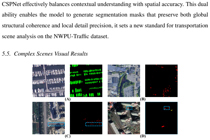
The paper's central claims are (1) construction of the new NWPU-Traffic dataset (1 479 images, four traffic classes, 49 cities/7 countries, instance masks) and (2) empirical superiority of CSPNet (SPFIM + CPFIM + LGFFD) on that dataset's 7:1:2 geographic split (mIoU 73.50, OA 98.76, F1 83.36 vs. DeepLabv3+, ABCNet, UNetFormer, GCBNet, ScaleFormer, CMLFormer, FSEL). Neither claim is a mathematical derivation. There are no equations that define a quantity in terms of the quantity later 'predicted', no parameters fitted to a subset and then re-reported as predictions, no uniqueness theorems imported from the authors' prior work, and no ansatz smuggled via self-citation. Self-citations (e.g., prior road-extraction or multi-scale papers by the same group) appear only as background motivation and are not load-bearing for the reported numbers. Ablations (Table 4) and external qualitative tests (Figs. 10-12) are consistent with the architecture story but do not create circular dependence. The work is therefore self-contained against external benchmarks; circularity score is zero.
Axiom & Free-Parameter Ledger
free parameters (3)
- base learning rate =
6e-4
- batch size / crop size =
4 / 512
- loss weighting (BCE + Dice)
axioms (3)
- domain assumption Standard supervised semantic-segmentation training with ResNet-34 ImageNet-pretrained encoder yields transferable multi-scale features for remote-sensing traffic objects.
- domain assumption Instance-level polygon masks on optical satellite imagery are a sufficient and unbiased proxy for evaluating regional transportation capacity.
- ad hoc to paper Pixel-shuffle / unshuffle and 3-D unfold operations preserve the spatial and channel information needed for accurate multi-scale fusion.
invented entities (2)
-
NWPU-Traffic dataset
no independent evidence
-
CSPNet (SPFIM + CPFIM + LGFFD)
no independent evidence
read the original abstract
Remote sensing imagery plays a crucial role in evaluating regional transportation capacity. However, existing segmentation datasets often lack diversity in object categories and scenes, limiting the ability of models to comprehensively evaluate trans portation capacity in real-world scenes. To alleviate this gap, we construct a large-scale and diverse dataset for transportation object segmentation, named as NWPU-Traffic. This dataset encompass four traffic object categories (car, airplane, ship, and train) and a wide range of scenes from 49 cities across 7 countries, with instance-level annotations to ensure precise segmentation of individual objects, which bridges critical shortcomings in resolution and scene diversity in existing datasets. Leveraging this dataset, we establish a benchmark with several popular segmentation networks. Furthermore, we propose a novel segmentation method that leverages spatial-channel preserving feature interaction and an adaptive feature decoder, enabling robust segmentation across varying scales and complex environments. Extensive experiments and ablation studies validate the effectiveness of our approach. The dataset and code are publicly available at https://github.com/CVer-Yang/NWPU-Traffic.
Figures




Reference graph
Works this paper leans on
-
[1]
T. Yang, Q. Zhou, Q. Wang, Dia: Deriving linguistic information from auxil- iary languages for remote sensing image captioning, Pattern Recognition (2025) 112209
2025
-
[2]
X. Chen, Q. Liu, H. H. Deng, T. Kuang, H. H.-Y . Lin, D. Xiao, J. Gateno, J. J. Xia, P.-T. Yap, Improving image segmentation with contextual and structural sim- ilarity, Pattern Recognition 152 (2024) 110489
2024
-
[3]
Z. Yang, D. Zhou, Y . Yang, J. Zhang, Z. Chen, Road extraction from satellite imagery by road context and full-stage feature, IEEE Geoscience and Remote Sensing Letters 20 (2022) 1–5. 25
2022
-
[4]
Zhang, K
J. Zhang, K. Yang, A. Constantinescu, K. Peng, K. Müller, R. Stiefelhagen, Trans4Trans: Efficient transformer for transparent object and semantic scene seg- mentation in real-world navigation assistance, IEEE Transactions on Intelligent Transportation Systems 23 (10) (2022) 19173–19186
2022
-
[5]
B. Ren, X. Yang, Y . Yu, J. Luo, Z. Deng, Pointobb-v2: Towards simpler, faster, and stronger single point supervised oriented object detection, arXiv preprint arXiv:2410.08210 (2024)
Pith/arXiv arXiv 2024
-
[6]
Z. Liu, H. Wang, L. Weng, Y . Yang, Ship rotated bounding box space for ship ex- traction from high-resolution optical satellite images with complex backgrounds, IEEE Geoscience and Remote Sensing Letters 13 (8) (2016) 1074–1078
2016
-
[7]
H. Zhu, X. Chen, W. Dai, K. Fu, Q. Ye, J. Jiao, Orientation robust object detection in aerial images using deep convolutional neural network, in: Proceedings of the IEEE International Conference on Image Processing, IEEE, 2015, pp. 3735– 3739
2015
-
[8]
W. Lin, Z. Wu, J. Chen, J. Huang, L. Jin, Scale-aware modulation meet trans- former, in: Proceedings of the IEEE/CVF International Conference on Computer Vision, 2023, pp. 6015–6026
2023
-
[9]
Zhang, X
H. Zhang, X. Zuo, J. Jiang, C. Guo, J. Ma, MRFS: Mutually Reinforcing Im- age Fusion and Segmentation, in: Proceedings of the IEEE/CVF Conference on Computer Vision and Pattern Recognition, 2024, pp. 26974–26983
2024
-
[10]
J. Zhan, Y . Luo, C. Guo, Y . Wu, J. Meng, J. Liu, Yolopx: Anchor-free multi-task learning network for panoptic driving perception, Pattern Recognition 148 (2024) 110152
2024
-
[11]
Cheng, P
G. Cheng, P. Zhou, J. Han, Learning rotation-invariant convolutional neural net- works for object detection in VHR optical remote sensing images, IEEE Transac- tions on Geoscience and Remote Sensing 54 (12) (2016) 7405–7415. 26
2016
-
[12]
Zhang, Y
Y . Zhang, Y . Yuan, Y . Feng, X. Lu, Hierarchical and robust convolutional neural network for very high-resolution remote sensing object detection, IEEE Transac- tions on Geoscience and Remote Sensing 57 (8) (2019) 5535–5548
2019
-
[13]
Z. Xiao, Q. Liu, G. Tang, X. Zhai, Elliptic fourier transformation-based his- tograms of oriented gradients for rotationally invariant object detection in remote- sensing images, International Journal of Remote Sensing 36 (2) (2015) 618–644
2015
-
[14]
Zhang, X
T. Zhang, X. Zhang, J. Li, X. Xu, B. Wang, X. Zhan, Y . Xu, X. Ke, T. Zeng, H. Su, et al., Sar ship detection dataset (ssdd): Official release and comprehensive data analysis, Remote Sensing 13 (18) (2021) 3690
2021
-
[15]
Z. Zou, Z. Shi, Random access memories: A new paradigm for target detection in high resolution aerial remote sensing images, IEEE Transactions on Image Processing 27 (3) (2017) 1100–1111
2017
-
[16]
Q. Li, Y . Yuan, Q. Wang, Multiscale factor joint learning for hyperspectral im- age super-resolution, IEEE Transactions on Geoscience and Remote Sensing 61 (2023) 1–10
2023
-
[17]
Q. Li, M. Gong, Y . Yuan, Q. Wang, RGB-induced feature modulation network for hyperspectral image super-resolution, IEEE Transactions on Geoscience and Remote Sensing 61 (2023) 1–11
2023
-
[18]
Zheng, Y
Z. Zheng, Y . Zhong, J. Wang, A. Ma, Foreground-aware relation network for geospatial object segmentation in high spatial resolution remote sensing imagery, in: Proceedings of the IEEE Conference on Computer Vision and Pattern Recog- nition, 2020, pp. 4096–4105
2020
-
[19]
Q. Zhu, X. Guo, Z. Li, D. Li, A review of multi-class change detection for satellite remote sensing imagery, Geo-spatial Information Science 27 (1) (2024) 1–15
2024
-
[20]
Q. Li, M. Zhang, Z. Yang, Y . Yuan, Q. Wang, Edge-Guided Perceptual Network for Infrared Small Target Detection, IEEE Transactions on Geoscience and Re- mote Sensing (2024). 27
2024
-
[21]
W. Yang, Y . Zhang, X. Liu, B. Gao, Scene adaptive building individual segmenta- tion based on large-scale airborne lidar point clouds, IEEE Transactions on Geo- science and Remote Sensing (2024)
2024
-
[22]
Z. Yang, W. Zhang, Q. Li, W. Ni, J. Wu, Q. Wang, C 2 Net: Road Extraction via Context Perception and Cross Spatial-Scale Feature Interaction, IEEE Transac- tions on Geoscience and Remote Sensing (2024)
2024
-
[23]
Z. Guo, H. Gan, CPP-Net: Embracing Multi-Scale Feature Fusion into Deep Unfolding CP-PPA Network for Compressive Sensing, in: Proceedings of the IEEE/CVF Conference on Computer Vision and Pattern Recognition, 2024, pp. 25086–25095
2024
-
[24]
H. Huang, S. Xie, L. Lin, Y . Iwamoto, X. Han, Y .-W. Chen, R. Tong, Scale- former: revisiting the transformer-based backbones from a scale-wise perspective for medical image segmentation, arXiv:2207.14552 (2022)
Pith/arXiv arXiv 2022
-
[25]
H. Wu, P. Huang, M. Zhang, W. Tang, X. Yu, CMTFNet: Cnn and multiscale transformer fusion network for remote-sensing image semantic segmentation, IEEE Transactions on Geoscience and Remote Sensing 61 (2023) 1–12
2023
-
[26]
Q. Zeng, J. Zhou, J. Tao, L. Chen, X. Niu, Y . Zhang, Multiscale global con- text network for semantic segmentation of high-resolution remote sensing images, IEEE Transactions on Geoscience and Remote Sensing 62 (2024) 1–13
2024
-
[27]
L. Li, J. Yi, H. Fan, H. Lin, A lightweight semantic segmentation network based on self-attention mechanism and state space model for efficient urban scene segmentation, IEEE Transactions on Geoscience and Remote Sensing (2025). doi:10.1109/TGRS.2025.3562185
-
[28]
Heitz, D
G. Heitz, D. Koller, Learning spatial context: Using stuff to find things, in: Pro- ceedings of the European Conference on Computer Vision, Springer, 2008, pp. 30–43
2008
-
[29]
T. N. Mundhenk, G. Konjevod, W. A. Sakla, K. Boakye, A large contextual dataset for classification, detection and counting of cars with deep learning, in: 28 Proceedings of the European Conference on Computer Vision, Springer, 2016, pp. 785–800
2016
-
[30]
Razakarivony, F
S. Razakarivony, F. Jurie, Vehicle detection in aerial imagery: A small target de- tection benchmark, Journal of Visual Communication and Image Representation 34 (2016) 187–203
2016
-
[31]
D. Lam, R. Kuzma, K. McGee, S. Dooley, M. Laielli, M. Klaric, Y . Bula- tov, B. McCord, xview: Objects in context in overhead imagery, arXiv preprint arXiv:1802.07856 (2018)
Pith/arXiv arXiv 2018
-
[32]
G.-S. Xia, X. Bai, J. Ding, Z. Zhu, S. Belongie, J. Luo, M. Datcu, M. Pelillo, L. Zhang, DOTA: A large-scale dataset for object detection in aerial images, in: Proceedings of the IEEE Conference on Computer Vision and Pattern Recogni- tion, 2018, pp. 3974–3983
2018
-
[33]
Airbus ship detection challenge dataset,https://www.kaggle.com/c/ airbus-ship-detection/, accessed: 2019-05-27 (2018)
2019
-
[34]
Waqas Zamir, A
S. Waqas Zamir, A. Arora, A. Gupta, S. Khan, G. Sun, F. Shahbaz Khan, F. Zhu, L. Shao, G.-S. Xia, X. Bai, isaid: A large-scale dataset for instance segmenta- tion in aerial images, in: Proceedings of the IEEE/CVF Conference on Computer Vision and Pattern Recognition Workshops, 2019, pp. 28–37
2019
-
[35]
L.-C. Chen, Y . Zhu, G. Papandreou, F. Schroff, H. Adam, Encoder-decoder with atrous separable convolution for semantic image segmentation, in: Proceedings of European Conference on Computer Vision, 2018, pp. 801–818
2018
-
[36]
R. Li, S. Zheng, C. Zhang, C. Duan, L. Wang, P. M. Atkinson, ABCNet: Attentive bilateral contextual network for efficient semantic segmentation of fine-resolution remotely sensed imagery, ISPRS Journal of Photogrammetry and Remote Sensing 181 (2021) 84–98
2021
-
[37]
L. Wang, R. Li, C. Zhang, S. Fang, C. Duan, X. Meng, P. M. Atkinson, UNet- Former: A unet-like transformer for efficient semantic segmentation of remote 29 sensing urban scene imagery, ISPRS Journal of Photogrammetry and Remote Sensing 190 (2022) 196–214
2022
-
[38]
H. Wu, M. Zhang, P. Huang, W. Tang, CMLFormer: CNN and Multi-scale Local- context Transformer network for remote sensing images semantic segmentation, IEEE Journal of Selected Topics in Applied Earth Observations and Remote Sens- ing (2024)
2024
-
[39]
Q. Zhu, Y . Zhang, L. Wang, Y . Zhong, Q. Guan, X. Lu, L. Zhang, D. Li, A global context-aware and batch-independent network for road extraction from vhr satellite imagery, ISPRS Journal of Photogrammetry and Remote Sensing 175 (2021) 353–365
2021
-
[40]
Y . Sun, C. Xu, J. Yang, H. Xuan, L. Luo, Frequency-spatial entanglement learning for camouflaged object detection, in: Proceedings of European Conference on Computer Vision, Springer, 2025, pp. 343–360. 30
2025
discussion (0)
Sign in with ORCID, Apple, or X to comment. Anyone can read and Pith papers without signing in.