REVIEW 2 major objections 6 minor 15 references
V2X-Based Vehicular Positioning: Opportunities, Challenges, and Future Directions
T0 review · 2 major / 6 minor · reviewed 2026-08-14 · deepseek-v4-flash
Pith's one-line read V2X signals can locate vehicles where GPS, radar, and lidar cannot
desk verdict A solid, well-structured survey of V2X positioning that is worth reading, but the headline 'seamless NLoS positioning' claim outruns the evidence, including the authors' own Fig. 5. read the letter →
The pith
A machine-rendered reading of the paper's core claim, the machinery that carries it, and where it could break.
The reading
What carries the argument
The central machinery is the set of positioning elements extracted from V2X waveforms—ToA/TDoA, PoA/PDoA, and AoA/AoD—combined with a dual-band complementarity argument. The 60 GHz band's beamformed sparsity gives accurate LoS measurements, while the 5.9 GHz band's persistent multipath supplies the NLoS clues; the multipath-geometry approach then uses AoA-AoD lines and TDoA differences from single-bounce paths to intersect a hidden vehicle's position. PDoA provides a bandwidth-efficient ranging alternative, and backscatter tags serve as low-cost anchors with known locations.
What would settle it
Measure the number of resolvable single-bounce multipath components at 5.9 GHz in a dense urban NLoS street using a real V2X waveform. If fewer than three single-bounce paths are available in a substantial fraction of channel realizations, or if their AoA/AoD/TDoA estimates are too noisy to intersect into a consistent position, the hidden-vehicle positioning method cannot run and the seamless-NLoS claim loses its support.
Extended reading notes
Core claim
On the paper's own terms, V2X-based vehicular positioning is feasible and can be seamless: the 60 GHz band, with beamforming, exposes a few dominant paths whose sparsity enables precise angle and time estimation in line-of-sight conditions, while the 5.9 GHz band, without beamforming, delivers many multipath components that remain observable even when the direct path is blocked. These NLoS paths can be exploited rather than discarded, enabling hidden-vehicle positioning through the geometric intersection of single-bounce paths carrying AoA, AoD, and TDoA measurements. The article also argues that phase-difference-of-arrival ranging can overcome the coarse time resolution of the 20 MHz 5.9 GHz band without costly oversampling, and that roadside backscatter tags can cheaply densify the anchor network.
Load-bearing premise
The claim of seamless NLoS positioning assumes that a vehicle can always detect enough resolvable single-bounce multipath components—at least two or three—with reliable AoA/AoD/TDoA estimates, and that real V2X channels actually provide this stable multipath geometry.
Editorial extensions
If this is right
- Autonomous vehicles could maintain positioning in urban canyons and other NLoS settings where GPS and onboard sensors lose lock, using only V2X waveforms.
- Waveform-based V2I and V2V positioning could augment or replace message-based cooperative positioning, reducing reliance on GPS-derived coordinates.
- Exploiting NLoS multipath, rather than rejecting it, turns building blockages from a liability into a source of geometric information.
- Phase-difference ranging could deliver useful accuracy over the narrow 5.9 GHz band without the cost of oversampling, making positioning cheaper to deploy.
- Roadside backscatter tags could make anchor densification affordable, extending positioning coverage in areas with few base stations or RSUs.
Reading between the lines
- A testable extension would be a field measurement campaign that compares the number of resolvable single-bounce paths at 5.9 GHz against the 2–3 path minimum the hidden-vehicle method requires, in realistic urban layouts.
- If the dual-band complementarity holds, the same architecture could extend to UAV positioning and control, since the paper's scenarios transfer from ground vehicles to aerial anchors and targets.
- The phase-ranging argument suggests that other narrowband V2X services could gain positioning capability almost for free, by reusing existing OFDM subcarrier pairs rather than adding new reference signals.
- Map information, already proposed to identify single-bounce scatterers, could be combined with the multipath-geometry method to disambiguate multi-bounce paths and relax the required path count.
Signed reviews
Editorial analysis
A structured set of objections, weighed in public.
Referee Report
Summary. The paper investigates whether Vehicle-to-Everything (V2X) communications can support vehicular positioning (VP) for autonomous driving. It argues that V2X has advantages over GPS, RADAR, LIDAR, and cameras, and that the 5.9 GHz and 60 GHz bands can jointly provide positioning in both line-of-sight (LoS) and non-line-of-sight (NLoS) environments. It reviews positioning techniques in 3GPP, IEEE, ETSI, and SAE standards, identifies their limitations, and proposes three research directions: phase-based positioning for band-limited scenarios, multipath-geometry-based hidden vehicle positioning, and backscatter tags as cost-effective anchors. The paper presents a simulation comparing ToA and PDoA ranging and a ray-tracing example of NLoS multipath.
Significance. If the claims are upheld, the paper would provide a useful roadmap for leveraging V2X infrastructure and standards for vehicle positioning, a critical gap for autonomous driving. Its strengths include a broad standardization review, a clear taxonomy of V2X positioning scenarios, and several concrete research directions grounded in prior work. The paper also makes falsifiable claims: the 'seamless' LoS/NLoS positioning capability and the quantitative advantage of PDoA over ToA. However, the evidence is not yet sufficient to support the headline 'seamless' claim, and the simulation in Fig. 3 lacks the details needed for reproducibility. The contribution is best read as a position/survey that identifies opportunities and open problems, not as a demonstration of an established capability.
major comments (2)
- [Section II-B and Section IV-B] The summary claim that 'V2X can provide seamless VP services in both LoS and NLoS environments' is not supported by the paper's own evidence. The NLoS mechanism is the hidden-vehicle positioning method of Section IV-B, which requires at least three usable signal paths (Fig. 4). However, the ray-tracing result in Fig. 5, obtained in a real NLoS environment, shows only two single-bounce paths among the top seven received-power paths, and the text explicitly states that 'the number of observable single-bounce paths is random and can be less than 3.' The proposed remedy of combining paths over time 'requires the vehicle's maneuver information' and movement tracking/prediction, whose accuracy is not demonstrated. Thus the 'seamless' claim is overstated; it should be qualified as a research opportunity with open feasibility questions, or supported by additional evidence that the temporal-combination approach actually works.
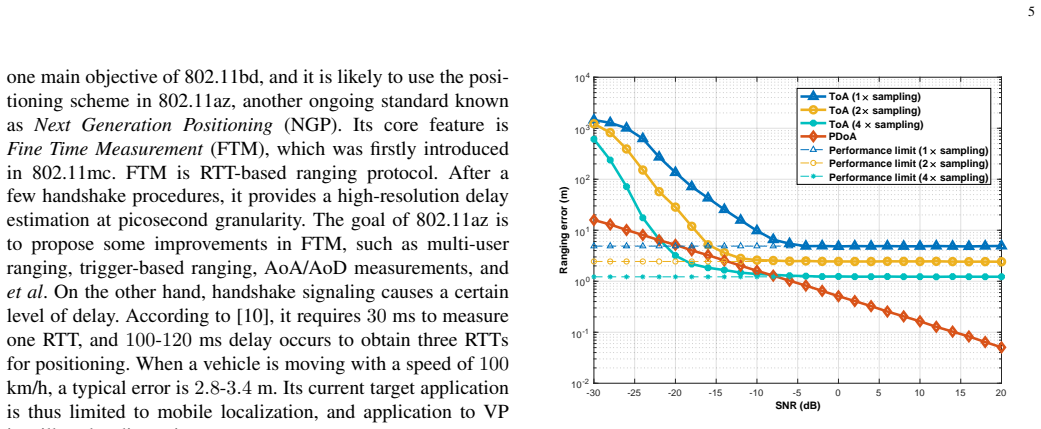
- [Section IV-A, Fig. 3] The quantitative comparison of ToA and PDoA ranging errors is not reproducible. The figure caption and text do not describe the ToA estimation algorithm (e.g., matched filtering, correlation peak detection), the number of Monte Carlo runs, the channel model beyond AWGN, or any error bars or confidence intervals. The claim that PDoA error 'keeps decreasing as SNR increases' while oversampled ToA has a constant sampling-error floor is the central motivation for the phase-based research direction. Without these experimental details, the reader cannot assess statistical significance or the validity of the conclusions under the stated V2X assumptions.
minor comments (6)
- [Section II-B] 'most paths are likely to arrive within a short delay-spread (around 5–30 µsec)' should presumably read '5–30 ns' to be consistent with the delay values in Fig. 5 and with typical V2V channel delay spreads; 5–30 µs corresponds to propagation distances of 1.5–9 km, which is not 'short' in this context.
- [Table I] The checkmark for 'Relying on GPS' under 3GPP is not supported by Section III-B 1: the described OTDoA and UTDoA methods rely on network synchronization among base stations, not on GPS for positioning. Please clarify or remove this entry.
- [Section III-A 2] 'It is thus recommended of using Phase-Difference-of-Arrival' should be 'it is recommended to use Phase-Difference-of-Arrival'; also 'a few recent studies on NLoS positioning ... aims at exploiting NLoS signal paths can enhance positioning performance' is ungrammatical and should be rewritten.
- [Section IV-B] 'The pair of the lines have one crossing point' should be 'The pair of the lines has one crossing point.'
- [Section IV-A, Fig. 3] The figure would be easier to interpret with markers on the curves and a table listing simulation parameters; the caption should also state the number of independent trials so the reader can judge the variability.
- [References] References [12] and [15] are the authors' own related work; the manuscript should state explicitly what is new in the present article relative to these prior papers.
Circularity Check
No significant circularity: the central V2X positioning claims are supported by external standards, independent channel simulations, and self-contained geometry, not by self-cited results.
full rationale
The paper is a survey/position article rather than a derivation of a new prediction from fitted inputs. Its central claim that V2X can provide seamless positioning in both LoS and NLoS environments is supported by documented propagation differences between the 5.9 GHz and 60 GHz bands, illustrated by the paper's own RSS simulation in Fig. 1 and grounded in an external 3GPP channel model. The PDoA-vs-ToA comparison in Fig. 3 is a standalone AWGN simulation with explicitly stated parameters and does not use a fitted parameter renamed as a prediction. The hidden-vehicle multipath-geometry method in Sec. IV-B is derived from elementary AoA/AoD/TDoA line intersections and is explicitly challenged by the paper's own ray-tracing result in Fig. 5, which admits that the number of observable single-bounce paths can be insufficient; this is a self-contained research direction with acknowledged open problems, not a conclusion forced by construction. The citations to the authors' own prior works [12] and [15] introduce research directions, but the article provides the underlying reasoning and limitations in the text, and these sections are not load-bearing for the paper's main feasibility argument, which rests on external standardization activities and physical propagation reasoning. No equation or predicted quantity reduces to its own input, and no fitted parameter is relabeled as a prediction. Therefore, there is no significant circularity.
Assumptions & free parameters
assumptions (5)
- domain assumption V2X channels at 5.9 GHz have rich NLoS multipath that can be exploited for positioning.
- domain assumption The 60 GHz V2X band has sparse multipath with a few dominant paths suitable for beamforming-based positioning.
- domain assumption A sufficient number of resolvable single-bounce paths is available for hidden vehicle positioning.
- domain assumption Auto-driving requires positioning accuracy around 0.1 m lateral and 0.5 m longitudinal error.
- domain assumption Standard positioning techniques (ToA, TDoA, AoA) require anchor synchronization and line-of-sight conditions.
Cite this review
Pith. "Pith review of V2X-Based Vehicular Positioning: Opportunities, Challenges, and Future Directions." pith.science (2026). https://pith.science/paper/LHRLLK5Y
@misc{pith2026190804606,
  author       = {Pith},
  title        = {Pith review of: V2X-Based Vehicular Positioning: Opportunities, Challenges, and Future Directions},
  year         = {2026},
  howpublished = {\url{https://pith.science/paper/LHRLLK5Y}},
  note         = {Machine review of arXiv:1908.04606}
}
read the original abstract
Vehicle-to-Everything (V2X) will create many new opportunities in the area of wireless communications, while its feasibility on enabling vehicular positioning has not been explored yet. Vehicular positioning is a crucial operation for autonomous driving. Its complexity and stringent safety requirement render conventional technologies like RADAR and LIDAR inadequate. This article aims at investigating whether V2X can help vehicular positioning from different perspectives. We first explain V2X's critical advantages over other approaches and suggest new scenarios of V2X-based vehicular positioning. Then we review the state-of-the-art positioning techniques discussed in the ongoing 3GPP standardization and point out their limitations. Lastly, some promising research directions for V2X-based vehicular positioning are presented, which shed light on realizing fully autonomous driving by overcoming the current barriers.
Figures


Figures from the paper (1 more)

Reference graph
Works this paper leans on
-
[1]
LTE evolution for vehicle-to-everything services,
H. Seo, K. Lee, S. Yasukawa, Y . Peng, and P. Sartori, “LTE evolution for vehicle-to-everything services,” IEEE Comm. Mag. , vol. 54, pp. 22–28, Jun. 2016
work page 2016
-
[2]
5G mmWave positioning for vehicular networks,
H. Wymeersch, G. Seco-Granados, G. Destino, D. Dardari, and F. Tufvesson, “5G mmWave positioning for vehicular networks,” IEEE Wireless Comm., vol. 24, pp. 80–86, Dec. 2017
work page 2017
-
[3]
Network design for accurate vehicle localization,
J. A. d. Peral-Rosado, G. Seco-Granados, S. Kim, and J. A. Lopez- Salcedo, “Network design for accurate vehicle localization,”IEEE Trans. Veh. Tech., vol. 68, pp. 4316–4327, May 2019
work page 2019
-
[4]
Study on evaluation methodology of new vehicle-to-everything (v2x) use cases for lte and nr,
3GPP, TR 37.885, v15.3.0, “Study on evaluation methodology of new vehicle-to-everything (v2x) use cases for lte and nr,” Available: http://www.3gpp.org/DynaReport/37885.htm
-
[5]
Positioning for NLOS propagation: Algorithm derivations and Cramer-Rao bounds,
H. Miao, K. Yu, and M. Juntti, “Positioning for NLOS propagation: Algorithm derivations and Cramer-Rao bounds,”IEEE Trans. Veh. Tech., vol. 56, pp. 2568–2580, Sep. 2007
work page 2007
-
[6]
Cooperative positioning for vehicular networks: Facts and future,
N. Alam and A. Dempster, “Cooperative positioning for vehicular networks: Facts and future,” IEEE Trans. Intell. Transp. Syst. , vol. 14, pp. 1708–1717, Dec. 2013
work page 2013
-
[7]
Study on enhancement of 3GPP support for 5G V2X services,
3GPP, TR 22.886 v16.1.1, “Study on enhancement of 3GPP support for 5G V2X services,” Available: http://www.3gpp.org/DynaReport/22886.htm
-
[8]
FCC drives 5.9 GHz proposal for C-V2X, Wi-Fi use forward,
B. Fletcher, “FCC drives 5.9 GHz proposal for C-V2X, Wi-Fi use forward,” FierceWireless, 12th Dec. 2019
work page 2019
Show all 15 references
-
[9]
Revised SID: Study on NR positioning support,
3GPP, RP-182155, “Revised SID: Study on NR positioning support,” 3GPP TSG RAN Meeting 81 , Sep. 2018
2018
-
[10]
High-accuracy indoor geolocation using collaborative time of arrival-whitepaper,
L. Banin, O. Bar-Shalom, N. Dvorecki, and Y . Amizur, “High-accuracy indoor geolocation using collaborative time of arrival-whitepaper,” IEEE 802.11-17/1397R0, Sep. 2017
2017
-
[11]
Intelligent transport system (ITS); vehicular communications; basic set of applications; facilities layer protocols and communication requirements for infrastructure services,
ETSI, TS 103.301, V1.3.1, “Intelligent transport system (ITS); vehicular communications; basic set of applications; facilities layer protocols and communication requirements for infrastructure services,” Feb. 2020
2020
-
[12]
Hidden vehicle sensing via asynchronous V2V transmission: A multi-path-geometry approach,
K. Han, S.-W. Ko, H. Chae, B.-H. Kim, and K. Huang, “Hidden vehicle sensing via asynchronous V2V transmission: A multi-path-geometry approach,” IEEE Access, vol. 7, pp. pp.169399–169419, Dec. 2019
2019
-
[13]
Map-assisted millimeter wave localization for accurate position location,
O. Kanhere, S. Ju, Y . Xing, and T. S. Rappaport, “Map-assisted millimeter wave localization for accurate position location,” in Proc. of IEEE GLOBECOM , Dec. 2019
2019
-
[14]
Vehicles on RFID: Error-cognitive vehicle localization in GPS-less environments,
H. Qin, Y . Peng, and W. Zhang, “Vehicles on RFID: Error-cognitive vehicle localization in GPS-less environments,” IEEE Trans. Veh. Tech., vol. 66, pp. 9943–9957, Nov. 2017
2017
-
[15]
Joint frequency- and-phase modulation for backscatter-tag assisted vehicular positioning,
K. Han, S.-W. Ko, S. Lee, W.-S. Ko, and K. Huang, “Joint frequency- and-phase modulation for backscatter-tag assisted vehicular positioning,” in Proc IEEE SPAWC, Jul. 2019
2019
Reviewed August 14, 2026 · model on record in the stance chip above.
Discussion (0). Continue with ORCID to comment.