REVIEW 4 major objections 5 minor 24 references
A Multimodal Vision Sensor for Autonomous Driving
T0 review · 4 major / 5 minor · reviewed 2026-08-14 · deepseek-v4-flash
Pith's one-line read This paper claims a compact three-camera sensor can give autonomous vehicles depth, 360-degree views, semantic labels, and polarization-based water-hazard detection in near real time.
desk verdict The hardware integration is real and the stereo-polarization pipeline is usable, but the water-hazard demonstration rests on one unvalidated threshold and a single qualitative image. read the letter →
The pith
A machine-rendered reading of the paper's core claim, the machinery that carries it, and where it could break.
The reading
What carries the argument
The central mechanism is the cross-modal registration between the left stereo camera and the polarization camera, treated as a second stereo pair. After calibrating intrinsics and extrinsics, a pixel in the left color image is reprojected to the polarization camera using the transformation $\mathbf{u}_{\text{polar}} = \pi(\mathbf{K}_{\text{polar}} \mathbf{T} \mathbf{K}_{\text{color}}^{-1}(z \cdot \dot{\mathbf{u}}_{\text{color}}))$, which lets the system assign a DOP value to every color pixel that falls in the polarization camera's field of view. This registration enables the fusion rule in Algorithm 1: if the semantic class is road and the corresponding DOP is at least 0.6, relabel the pixel as water hazard. The polarization camera itself uses a pixel-level wire-grid polarizer array to measure Stokes parameters, from which DOP is computed.
What would settle it
Take the assembled sensor to a variety of outdoor scenes under different lighting and weather, with controlled water puddles on both asphalt and concrete, and compute detection accuracy against manual ground-truth labels; if dry shiny roads frequently exceed DOP 0.6, the threshold fails. Alternatively, plot detection rate versus threshold across many scenes to see whether 0.6 is stable or arbitrary.
Extended reading notes
Core claim
The authors assembled a multimodal sensor that combines three cameras: a stereo camera for per-pixel depth, a polarization camera that measures degree of linear polarization (DOP), and a panoramic annular lens (PAL) for 360-degree imagery. They calibrate the left stereo camera and the polarization camera as a new stereo pair, allowing them to reproject pixels from one image plane to the other. Using this registration, they run a semantic segmentation network (ERF-PSPNet) on the left color image, then detect water hazards by thresholding DOP on road-class pixels: pixels that are classified as road and have DOP ≥ 0.6 are labeled as water hazards. The sensor is demonstrated on a campus street, showing that polarization can reveal specular surfaces that semantic segmentation alone cannot label. The authors also report runtime performance across different platforms, from an NVIDIA Jetson TX2 to a desktop GPU, showing frame rates from 2.8 to 21.2 FPS depending on resolution.
Load-bearing premise
The water-hazard detection rests entirely on a hard-coded rule that any road pixel with degree of polarization at least 0.6 is a water hazard, a threshold tested on one campus image with no sensitivity analysis.
Editorial extensions
If this is right
- If the water-hazard detection rule holds, vehicles and robots can identify puddles, glass doors, and other specular hazards without retraining semantic segmentation networks on rare classes.
- The registration method can be reused for any pair of cameras with known intrinsics and extrinsics, enabling fusion of depth and polarization beyond the specific stereo camera used here.
- The sensor's reported frame rates (up to 21 FPS at low resolution on a desktop GPU) suggest that the multimodal pipeline could run on embedded devices for near-real-time driving assistance.
- The compact design, without LiDAR, makes the sensor suitable for drones or small robots where weight and power are limited.
- The panoramic annular lens provides a 360-degree field of view that, when unwrapped, can support surrounding perception tasks beyond the forward-facing stereo camera.
Reading between the lines
- The fixed DOP threshold of 0.6 is likely scene-dependent; a more robust detector might learn the threshold per environment or combine polarization with temporal cues to avoid false positives from dry shiny asphalt.
- The reported semantic segmentation accuracy (71.5% mIoU on Cityscapes, 54.3% on Mapillary Vistas) is only on a handful of classes; combining polarization with segmentation could improve detection of other specular objects like glass walls, which are similarly missed by standard datasets.
- The cross-modal registration assumes the cameras are rigidly mounted and time-synchronized; in practice, vibration or thermal drift could break the pixel correspondence, suggesting that an online recalibration step would help long-term deployment.
- The water-hazard demonstration uses a single campus image; a natural extension would be to validate the method across seasons, weather conditions, and times of day, and to compare against ground-truth water annotations.
Signed reviews
Editorial analysis
A structured set of objections, weighed in public.
Referee Report
Summary. The manuscript describes an integrated multimodal vision sensor for autonomous driving, combining a ZED Mini stereo camera, a Lucid polarization camera with a VisionDatum lens, and a panoramic annular lens camera. It applies standard stereo triangulation, Stokes-parameter-based DoLP computation, and reprojection-based registration to demonstrate semantic segmentation and water hazard detection, and reports frame rates on a Jetson TX2 and a desktop GPU platform. The central claim is that the assembled unit provides a practical multimodal perception platform for autonomous driving, with depth, 360-degree imagery, semantic labels, and polarization-based water hazard cues.
Significance. If validated, the sensor integration is of genuine interest to the autonomous driving and robotic perception communities: it combines dense stereo depth, compact 360-degree panoramic imaging, and polarization-based specular cues in a single portable device, and includes a semantic segmentation network and runtime measurements. The main conceptual value is the cross-modal registration of the stereo and polarization cameras, which could indeed support water hazard and other specular-object cues. However, the paper's only quantitative demonstration that the polarization channel adds value is the water hazard example, and that example currently rests on a single image and an unvalidated threshold. The hardware description and the standard perception equations are sound, but the evidence for the fusion pipeline is not yet at the level needed to support the paper's practical-platform claim.
major comments (4)
- [Section 4.2, Algorithm 1] The water hazard detector reclassifies every road-class pixel with DOP greater than or equal to 0.6 as a water hazard. The paper supports this fixed threshold with a single campus image and no ground-truth labels, no precision/recall numbers, no sensitivity analysis over delta, and no variation of lighting, weather, water depth, or viewing angle. Since DoLP depends on incidence angle and surface properties through the Fresnel equations in Eq. (3), the cutoff cannot be assumed to transfer to the Lucid camera or to a moving vehicle. Please provide a quantitative evaluation with labeled water and dry-road pixels across multiple scenes and lighting conditions, and report a threshold sweep and detection accuracy, or explicitly limit the claim to an illustrative example.
- [Section 4.2, Eq. (6)] The reprojection from the left stereo camera to the polarization camera uses z from the stereo depth map, but the paper does not state how invalid or missing stereo depth is handled, nor does it report calibration or reprojection error between the two cameras. Without such validation, the geometric accuracy of the fused water hazard regions is unknown. Please add a quantitative registration metric (e.g., reprojection error on a calibration target) and a description of depth preprocessing.
- [Section 4.1, Table 1] The table row labeled 'mIoU' reports 54.3, while the text says the network achieves 54.3% mIoU for 27 classes on Mapillary Vistas; the table appears to list only six classes, so it is unclear whether 54.3 is the 27-class average or the mean over the six listed classes. Please clarify the metric and report the full-class mIoU together with the per-class numbers.
- [Section 4.3, Table 2] The runtime comparison does not specify which algorithms are included in the FPS measurement, what resolution each camera ran at, whether the semantic segmentation, polarization processing, and PAL unwrapping are all counted, or whether synchronization overhead is included. As a result, Table 2 does not substantiate the 'near real time' claim. Please provide a per-module latency breakdown and a clear description of the measurement procedure.
minor comments (5)
- [Section 3.2, Eq. (3)] The Fresnel formulas appear to contain typographical errors: the expression for rp uses n2 in both the numerator and denominator, and the denominators of the transmission coefficients are not written consistently with the standard forms. Please check these formulas against a standard optics reference.
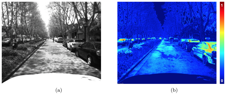
- [Section 3.2, Figure 3] The caption of Figure 3 says 'Visualization of depth measurement,' but the figure shows a polarization image and its alignment to the left color image; the caption appears to be copied from Figure 1. Please correct it.
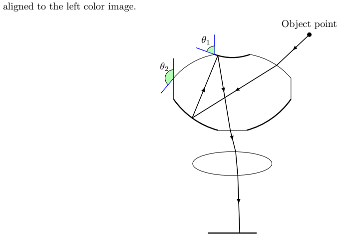
- [Section 3.3] There are several typos in the hardware description, including 'relative aperature aperture' and 'refracion'; please proofread the text.
- [Section 4.2] The claim that the water hazard detection is 'highly efficient and accurate' is not supported by any quantitative result at that point in the paper; please soften the wording or add the evaluation requested above.
- [Conclusion] The closing paragraph cites several applications of the sensor to panoramic scene parsing, localization, and nighttime understanding without details; please either describe these briefly or cite the relevant publications more precisely so readers can verify the claims.
Circularity Check
No significant circularity; the water hazard example reuses the authors' prior DOP>=0.6 ansatz, but the central sensor claims rest on independent engineering.
-
ansatz smuggled in via citation
[Section 4.2, Algorithm 1 (Water hazard detection)]
"To find out the water hazard area, Algorithm 1 inspired by 21 is applied, and the segmentation result is shown in Fig. 8. ... 2: δ← 0.6 ⊿ input water area DOP threshold ... 5: if class(ucolor) = road and (DOP (upolar)≥δ) then 6: class(ucolor)← water hazard"
The water hazard detector's only water-specific content is the DOP>=0.6 rule, which is imported from reference [21], a paper sharing author Kailun Yang with this work. The present paper supplies no independent derivation, ground-truth validation, or sensitivity analysis for this threshold; hence the 'detected' water hazard set is, by construction, exactly the set of road pixels whose DOP exceeds the threshold. The cross-modal demonstration therefore restates the authors' prior ansatz rather than testing it. This is a minor self-citation because the sensor integration, stereo depth, and semantic segmentation are independently benchmarked.
full rationale
The paper's core contributions are hardware integration and standard perception pipelines: stereo depth via calibration, rectification, and correspondence (Eqs. 1-2); semantic segmentation trained on Cityscapes and Mapillary Vistas and evaluated by mIoU on those external benchmarks; cross-modal reprojection via standard intrinsics and extrinsics (Eq. 6); PAL unwrapping; and runtime FPS measurements. None of these reduce to a fitted parameter or to a self-citation; they are self-contained engineering demonstrations. The only questionable step is the water hazard detector in Algorithm 1: the classification rule 'road and DOP>=0.6' is introduced as an input and attributed to the authors' own prior work [21]. No ground-truth evaluation or sensitivity analysis supports the 0.6 cutoff, so the water hazard image is essentially the defining rule applied to a single campus scene. That is a validation weakness and a minor self-citation, but it is an illustrative example rather than the load-bearing derivation of the sensor's central claim. Accordingly, the paper has no significant circularity; a score of 2 reflects the one minor self-cited ansatz.
Assumptions & free parameters
free parameters (2)
- DOP threshold delta =
0.6
- Cross-modal calibration parameters (K, R, T) =
not reported
assumptions (4)
- standard math Pinhole camera model and rigid-body transformation describe the stereo and polarization cameras (Eq. 6-7).
- domain assumption Circular polarization S3 is negligible in natural scenes.
- domain assumption High degree of linear polarization on road surfaces indicates water or other specular hazards.
- domain assumption Semantic segmentation trained on Cityscapes and Mapillary transfers to the authors' campus scenes without fine-tuning.
Cite this review
Pith. "Pith review of A Multimodal Vision Sensor for Autonomous Driving." pith.science (2026). https://pith.science/paper/LLTWGULS
@misc{pith2026190805649,
  author       = {Pith},
  title        = {Pith review of: A Multimodal Vision Sensor for Autonomous Driving},
  year         = {2026},
  howpublished = {\url{https://pith.science/paper/LLTWGULS}},
  note         = {Machine review of arXiv:1908.05649}
}
read the original abstract
This paper describes a multimodal vision sensor that integrates three types of cameras, including a stereo camera, a polarization camera and a panoramic camera. Each sensor provides a specific dimension of information: the stereo camera measures depth per pixel, the polarization obtains the degree of polarization, and the panoramic camera captures a 360-degree landscape. Data fusion and advanced environment perception could be built upon the combination of sensors. Designed especially for autonomous driving, this vision sensor is shipped with a robust semantic segmentation network. In addition, we demonstrate how cross-modal enhancement could be achieved by registering the color image and the polarization image. An example of water hazard detection is given. To prove the multimodal vision sensor's compatibility with different devices, a brief runtime performance analysis is carried out.
Figures


Figures from the paper (5 more)


Reference graph
Works this paper leans on
-
[21]
Yang, K., Bergasa, L. M., Romera, E., Wang, J., Wang, K., and L´ opez, E., “Perception framework of water hazards beyond traversability for real-world navigation assistance systems,” in [ 2018 IEEE International Conference on Robotics and Biomimetics (ROBIO) ], 186–191, IEEE (December 2018)
work page 2018
-
[1]
Super-sensor for 360-degree environment perception: Point cloud segmentation using image features,
Varga, R., Costea, A., Florea, H., Giosan, I., and Nedevschi, S., “Super-sensor for 360-degree environment perception: Point cloud segmentation using image features,” in [ 2017 IEEE 20th International Conference on Intelligent Transportation Systems (ITSC) ], 1–8, IEEE (2017)
work page 2017
-
[2]
Fusing semantic labeled camera images and 3d lidar data for the detection of urban curbs,
Goga, S. E. C. and Nedevschi, S., “Fusing semantic labeled camera images and 3d lidar data for the detection of urban curbs,” in [2018 IEEE 14th International Conference on Intelligent Computer Communication and Processing (ICCP)], 301–308, IEEE (2018)
work page 2018
-
[3]
Can we pass beyond the field of view? panoramic annular semantic segmentation for real-world surrounding perception,
Yang, K., Hu, X., Bergasa, L. M., Romera, E., Huang, X., Sun, D., and Wang, K., “Can we pass beyond the field of view? panoramic annular semantic segmentation for real-world surrounding perception,” in [ 2019 IEEE Intelligent Vehicles Symposium (IV). IEEE ], 374–381 (June 2019)
2019
-
[4]
Unifying terrain awareness for the visually impaired through real-time semantic segmentation,
Yang, K., Wang, K., Bergasa, L. M., Romera, E., Hu, W., Sun, D., Sun, J., Cheng, R., Chen, T., and L´ opez, E., “Unifying terrain awareness for the visually impaired through real-time semantic segmentation,” Sensors 18(5), 1506 (2018)
2018
-
[5]
Semantic perception of curbs beyond traversability for real-world navigation assistance systems,
Yang, K., Bergasa, L. M., Romera, E., Sun, D., Wang, K., and Barea, R., “Semantic perception of curbs beyond traversability for real-world navigation assistance systems,” in [2018 IEEE International Conference on Vehicular Electronics and Safety (ICVES) ], 1–7, IEEE (September 2018)
work page 2018
-
[6]
The cityscapes dataset for semantic urban scene understanding,
Cordts, M., Omran, M., Ramos, S., Rehfeld, T., Enzweiler, M., Benenson, R., Franke, U., Roth, S., and Schiele, B., “The cityscapes dataset for semantic urban scene understanding,” in [ Proc. of the IEEE Con- ference on Computer Vision and Pattern Recognition (CVPR) ], (2016)
work page 2016
-
[7]
The mapillary vistas dataset for semantic understanding of street scenes,
Neuhold, G., Ollmann, T., Bul` o, S. R., and Kontschieder, P., “The mapillary vistas dataset for semantic understanding of street scenes,” in [ 2017 IEEE International Conference on Computer Vision (ICCV) ], 5000–5009, IEEE (2017)
2017
Show all 24 references
-
[8]
6d-vision: Fusion of stereo and motion for robust environment perception,
Franke, U., Rabe, C., Badino, H., and Gehrig, S., “6d-vision: Fusion of stereo and motion for robust environment perception,” in [ Joint Pattern Recognition Symposium ], 216–223, Springer (2005)
2005
-
[9]
Towards reliable multimodal sensing in aware environments,
Stillman, S. and Essa, I., “Towards reliable multimodal sensing in aware environments,” in [ Proceedings of the 2001 workshop on Perceptive user interfaces ], 1–6, ACM (2001)
2001
-
[10]
3d lidar + monocular camera: an inverse- depth induced fusion framework for urban road detection,
Gu, S., Lu, T., Zhang, Y., Alvarez, J. M., Yang, J., and Kong, H., “3d lidar + monocular camera: an inverse- depth induced fusion framework for urban road detection,” IEEE Transactions on Intelligent Vehicles PP, 1–1 (06 2018)
2018
-
[11]
Tracking people with networks of heterogeneous sensors,
Brooks, A. and Williams, S., “Tracking people with networks of heterogeneous sensors,” in [ Proceedings of the Australasian Conference on Robotics and Automation ], 1–7, Citeseer (2003)
2003
-
[12]
and Bradski, G., [ Learning OpenCV 3: computer vision in C++ with the OpenCV library ], ” O’Reilly Media, Inc.” (2016)
Kaehler, A. and Bradski, G., [ Learning OpenCV 3: computer vision in C++ with the OpenCV library ], ” O’Reilly Media, Inc.” (2016)
2016
-
[13]
Computing rectifying homographies for stereo vision,
Loop, C. and Zhang, Z., “Computing rectifying homographies for stereo vision,” in [ Proceedings. 1999 IEEE Computer Society Conference on Computer Vision and Pattern Recognition (Cat. No PR00149) ], 1, 125–131, IEEE (1999)
1999
-
[14]
Pmf: A stereo correspondence algorithm using a disparity gradient limit,
Pollard, S. B., Mayhew, J. E., and Frisby, J. P., “Pmf: A stereo correspondence algorithm using a disparity gradient limit,” Perception 14(4), 449–470 (1985)
1985
-
[15]
A taxonomy and evaluation of dense two-frame stereo correspondence algorithms,
Scharstein, D. and Szeliski, R., “A taxonomy and evaluation of dense two-frame stereo correspondence algorithms,” International journal of computer vision 47(1-3), 7–42 (2002)
2002
-
[16]
Target enhanced 3d reconstruction based on polarization-coded structured light,
Huang, X., Bai, J., Wang, K., Liu, Q., Luo, Y., Yang, K., and Zhang, X., “Target enhanced 3d reconstruction based on polarization-coded structured light,” Optics express 25(2), 1173–1184 (2017)
2017
-
[17]
Light backscattering polarization patterns from turbid media: theory and experiment,
Rakovi´ c, M. J., Kattawar, G. W., Mehr˝ ubeo˘ glu, M., Cameron, B. D., Wang, L. V., Rastegar, S., and Cot´ e, G. L., “Light backscattering polarization patterns from turbid media: theory and experiment,” Applied optics 38(15), 3399–3408 (1999)
1999
-
[18]
H., [ Polarized light ], CRC press (2016)
Goldstein, D. H., [ Polarized light ], CRC press (2016)
2016
-
[19]
Catadioptric omnidirectional camera,
Nayar, S. K., “Catadioptric omnidirectional camera,” in [ Proceedings of IEEE computer society conference on computer vision and pattern recognition ], 482–488, IEEE (1997)
1997
-
[20]
A toolbox for easily calibrating omnidirectional cameras,
Scaramuzza, D., Martinelli, A., and Siegwart, R., “A toolbox for easily calibrating omnidirectional cameras,” in [2006 IEEE/RSJ International Conference on Intelligent Robots and Systems ], 5695–5701, IEEE (2006)
2006
-
[22]
Panoramic annular localizer: Tackling the variation challenges of outdoor localization using panoramic annular images and active deep descriptors,
Cheng, R., Wang, K., Lin, S., Hu, W., Yang, K., Huang, X., Li, H., Sun, D., and Bai, J., “Panoramic annular localizer: Tackling the variation challenges of outdoor localization using panoramic annular images and active deep descriptors,” arXiv preprint arXiv:1905.05425 (2019)
2019 arXiv
-
[23]
Bridging the day and night domain gap for semantic segmentation,
Romera, E., Bergasa, L. M., Yang, K., Alvarez, J. M., and Barea, R., “Bridging the day and night domain gap for semantic segmentation,” in [ 2019 IEEE Intelligent Vehicles Symposium (IV) ], 1184–1190, IEEE (June 2019)
2019
-
[24]
See clearer at night: Towards robust nighttime semantic segmentation through day-night image conversion,
Sun, L., Wang, K., Yang, K., and Xiang, K., “See clearer at night: Towards robust nighttime semantic segmentation through day-night image conversion,” in [ Artificial Intelligence and Machine Learning in Defense Applications ], International Society for Optics and Photonics (2019)
2019
Reviewed August 14, 2026 · model on record in the stance chip above.
Discussion (0). Continue with ORCID to comment.