REVIEW 5 major objections 7 minor 36 references
IGraSS: Learning to Identify Infrastructure Networks from Satellite Imagery by Iterative Graph-constrained Semantic Segmentation
T0 review · 5 major / 7 minor · reviewed 2026-08-07 · deepseek-v4-flash
Pith's one-line read IGraSS alternately trains a semantic segmentation network and applies graph-based network completion to add pseudo-links connecting unreachable canal fragments to water sources, cutting unreachable canal pixels from roughly 18% to 3% and…
desk verdict A solid applied paper on iterative graph-constrained segmentation for canal mapping; the main accuracy claim survives conventional metrics, though it needs variance reporting and independent validation of the pseudo-labels. read the letter →
The pith
A machine-rendered reading of the paper's core claim, the machinery that carries it, and where it could break.
The reading
What carries the argument
The central object is the iterative learner–solver loop: a semantic segmentation network (DeepLabV3+, ResUNet, ResNet50, or Swin Transformer) acting on RGB plus NDWI plus DEM patches, and a graph-based constraint solver operating on the full mosaic. The solver computes reachable pixels from water sources by 8-connected BFS, identifies unreachable terminal endpoints, and for each terminal builds a local weighted subgraph where each pixel's weight is $1/w_i(v)$ if the learner's likelihood $w_i(v)$ exceeds a confidence threshold $\alpha$ (otherwise the weight is 0), then uses Dijkstra's shortest path to connect the terminal to the nearest reachable source. The added path pixels become positive pseudo-labels in the next round's training mask. The paper also introduces r-neighborhood metrics (rTP, rFP, rFN and derived scores) that tolerate one-pixel misalignment in thin-structure annotations.
What would settle it
Take a region with verified, complete canal ground truth (for example, hand-digitized from high-resolution imagery), inject a known false canal segment or delete one water source from the source set, run IGraSS, and check whether the added pseudo-links follow the false topology and whether retrained models become worse on the verified map than the original labels. Alternatively, apply IGraSS to a dataset where canals are fed by pumps or tanks not connected to the mapped source set and measure whether completion adds phantom links.
Extended reading notes
Core claim
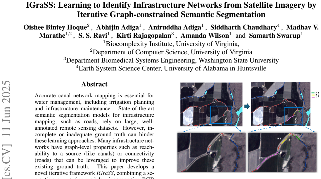
IGraSS's central claim is that iterative ground-truth refinement via graph-constrained pseudo-labels improves canal identification beyond what the same segmentation models achieve when trained on the original labels. The framework views the canal map as a grid graph, marks pixels reachable from a water source set $F$ by breadth-first search, detects unreachable terminal endpoints, and solves a node-weighted shortest-path problem in a local graph around each terminal to connect it to a reachable node. These added paths are positive pseudo-labels that update the training mask for the next iteration. The paper reports that this reduces unreachable canal segments from around 18% to 3% and improves all tested models on both conventional and r-neighborhood metrics; with Swin Transformer as learner, F1 improves from 0.770 to 0.815 on Test Set 1. The same loop, with shortest-path distance as the constraint, also repairs artificially introduced gaps in road networks.
Load-bearing premise
The method assumes the supplied canal ground truth is incomplete but never wrong, and that reachability from the given water-source set is the correct property of every visible canal; if a source is missing or a label is a false positive, the shortest-path repairs can encode hallucinated topology that retraining then amplifies.
Editorial extensions
If this is right
- Canal mapping for water management and irrigation planning can be improved without new satellite data or manual annotation, just by iterating segmentation with reachability constraints.
- The framework is general: any infrastructure network with a graph property (connectivity, reachability, planarity) can be treated the same way; the road-network experiment demonstrates this with a shortest-path objective.
- The released refined canal labels for Washington state provide a cleaner training resource for subsequent remote-sensing models.
- The r-neighborhood metrics offer a practical evaluation standard for thin linear structures, where pixel-perfect annotations misalign with satellite imagery.
Reading between the lines
- If the true ground truth contains false positives (for example, dried-up or underground canals still present in the source hydrography), the pseudo-label loop may propagate these errors; a robust variant would filter added links by multi-image agreement or by confidence before committing them.
- The reliance on a predefined water-source set $F$ could be relaxed by jointly predicting sources from imagery (e.g., water-body segmentation), which would make the framework applicable where source maps do not exist.
- This is essentially a self-training loop, so a useful stress test is to run IGraSS with a deliberately skewed or incomplete source set and measure how quickly hallucinated shortest-path links degrade downstream metrics on verified ground truth.
- Because the loop produces a connectivity-consistent map at each time step, comparing refined maps across years could flag new canal construction or canal-to-pipe conversions, turning the framework into a change-detection tool.
Editorial analysis
A structured set of objections, weighed in public.
Referee Report
Summary. The paper proposes IGraSS, an iterative framework that alternates a semantic segmentation learner with a graph-constrained refinement module. The refinement module treats the predicted canal mask as a graph, identifies unreachable terminal pixels, and connects them to reachable sources via shortest paths in the learner's confidence-weighted grid, adding pseudo-labels to the training data. Experiments on two spatially separated canal test sets in Washington report consistent improvements across three segmentation backbones (ResUNet, DeepLabv3+, Swin Transformer) in both conventional and r-neighborhood metrics, and a road-network experiment demonstrates generalization under a different graph constraint (shortest-path minimization). The authors release code and refined canal data.
Significance. If the claims hold, IGraSS provides a practical method for exploiting global structural constraints in weakly labeled infrastructure mapping, with a reproducible pipeline and released data. The strengths are the consistent gains across three backbones and two held-out test sets, the explicit inclusion of conventional P/R/F1/IoU in Table 1, and the road-network transfer experiment. The main limitations are the absence of uncertainty quantification, the unspecified evaluation radius r for the r-neighborhood metrics, and a refinement objective that can amplify label errors if the underlying assumptions of incomplete-but-not-erroneous ground truth and complete water-source sets are violated.
major comments (5)
- [§3.5, Table 1] The r-neighborhood metrics are defined in Section 3.5 with an unspecified radius r. The main tables report both conventional and r-metric columns, but no value of r is given for any reported result, so the reader cannot assess how much of the rF1/rI improvements depends on this parameter. Please state r for the reported numbers, and include a sensitivity analysis over r (e.g., r = 1, 2, 5) to show that the conclusion that IGraSS improves all metrics is stable. Additionally, Table 1 reports single point estimates without standard deviations or significance tests; the word 'significantly' in Section 5.1 is therefore not statistically supported.
- [§5.1, Table S3] The main text states that IGraSS was run with an initial confidence threshold α of 0.2, later reduced to 0.01 for optimal results, but the supplementary parameter analysis in Table S3 shows that for DeepLabv3+, ResNet50, and ResUNet the best metric performance occurs at α = 0.1 or 0.2, while α = 0.01 reduces unreachable nodes but generally lowers F1. The exact α schedule used to produce Table 1 is not specified, and the phrase 'for optimal result' is ambiguous in light of the trade-off. Please state the precise configuration for the final results and report conventional P/R/F1/IoU for that configuration, so that the central claim that refined ground truth improves canal identification is unambiguous.
- [§3.2, Appendix B] The inference goal in Section 3.2 assumes that the ground-truth canal network is 'incomplete (but not erroneous),' and the refinement module relies on reachability to the source set F. The paper filters unreachable nodes by intersecting with the ground-truth unreachable set (Appendix B), but it does not quantify the false-positive rate of the NHD labels or the completeness of the water-source set F. Because shortest paths are computed through the learner's confidence field, any systematic model bias can be propagated into pseudo-labels and reinforced during retraining. Please add a sensitivity analysis in which a small fraction of ground-truth edges is randomly corrupted, or a fraction of source nodes is removed, and measure the effect on the final held-out test performance and completion accuracy.
- [§5.1, Figure 4] The reported reduction in unreachable canals from roughly 18% to 3% is computed on the training region that the framework itself is refining, so this statistic partly measures the framework's success at changing its own training labels rather than an independent evaluation of completion quality. Table S2 does report reachability on the test sets, but it is not summarized as a percentage reduction. Please report the reachability statistics on both held-out test sets as percentages, and compare with a control that adds the same number of pseudo-label pixels without a connectivity constraint, to demonstrate that the graph constraint, rather than the added label volume, drives the improvement.
- [Appendix D, §3.5] The training pipeline uses a dilation of 4 pixels on the ground-truth masks (Appendix D), while the evaluation includes the r-neighborhood metrics from Section 3.5. These two choices can interact: a model trained on dilated labels will naturally achieve higher rTP for small r even if its topology is unchanged. The paper does not state whether the test labels are dilated, nor does it justify the evaluation radius relative to the training dilation. Please clarify the evaluation protocol and show that the r-metric gains reflect structural improvement rather than the added label thickness.
minor comments (7)
- [Abstract, §5.1] The abstract says IGraSS 'reduces unreachable canal segments from around 18% to 3%,' while Section 5.1 says 'from (18−15)% to (5−3)%'; these numbers should be aligned.
- [Table 3] Table 3 has repeated column headers ('rI rI rF1 rI'); the intended columns should list conventional and r-neighborhood precision, recall, F1, and IoU separately.
- [Algorithm 2] Algorithm 2 uses the parameter name th in its pseudocode, while the main text calls this parameter the confidence threshold α; a single symbol should be used throughout.
- [§3.5] The definition of the r-neighborhood true-positive metric should state explicitly that N_r(i,j) is the Chebyshev ball of radius r around pixel (i,j), rather than leaving the neighborhood shape implicit.
- [§4, Table 2] The text in Section 4 says four deep learning models were evaluated (DeepLabv3+, ResNet50, ResUNet, Swin Transformer), but Table 2 reports results for only DeepLab, ResUNet, and Swin; please add the ResNet50 row or correct the text.
- [Appendix D] Appendix D states that 'we selected a dilation level of 4 for our subsequent analysis,' but Figure S7 shows results for dilations 2, 4, and 8; make the link between this choice and the final tables explicit.
- [References] The reference for Swin Transformer is cited as He et al. (2022), which is not the original Swin Transformer architecture paper; the original citation (Liu et al., 2021) should be added.
Circularity Check
No significant circularity: the main claim is tested on held-out labels, and the refinement loop is broken for evaluation.
full rationale
The paper's central claim—that training with IGraSS-refined ground truth significantly improves canal identification (Section 5.1, Table 1)—is evaluated on spatially separated held-out test sets whose labels are not modified by IGraSS. Appendix A explicitly states, "We do not modify or examine any data from the test set while running IGraSS," so the self-training loop is broken for evaluation. The refinement module uses the learner's own thresholded predictions to add pseudo-labels, but the test-time evaluation against original NHD labels provides an independent check that could have failed. The reported reduction in unreachable canal segments from about 18% to 3% (Figure 4) is a diagnostic of the algorithm's own network-completion step rather than an external prediction; however, the paper does not rely on this as evidence for improved identification, which instead rests on the held-out comparison. No load-bearing self-citations, imported uniqueness theorems, or ansatz-by-citation chains appear in the manuscript. The unspecified radius r for the r-neighborhood metrics is a reproducibility concern, not a circularity, because conventional P/R/F1/IoU metrics are also reported and show the same qualitative improvement.
Assumptions & free parameters
free parameters (7)
- Pre-completion likelihood threshold tau =
0.5
- Confidence threshold alpha for local graph weights =
Initially 0.2, later reduced to 0.01
- Radius rho for source-terminal pairing =
100
- Number of iterations =
5
- Epochs per iteration =
20, with 10 used for low alpha cases
- Dilation kernel size =
4
- Dataset filtering thresholds =
Exclude patches with over 30% black pixels or under 0.5% canal pixels
assumptions (5)
- domain assumption The ground-truth canal network is incomplete but not erroneous.
- domain assumption Every canal node must be reachable from a water source in the provided set F.
- ad hoc to paper The shortest weighted path through the model confidence grid between a terminal and a reachable source corresponds to the true canal centerline.
- domain assumption Satellite imagery and NHD shapefile labels are correctly co-registered at the pixel grid level.
- ad hoc to paper Minimizing the sum of all-pairs shortest path lengths is a valid objective for repairing road networks.
Cite this review
Pith. "Pith review of IGraSS: Learning to Identify Infrastructure Networks from Satellite Imagery by Iterative Graph-constrained Semantic Segmentation." pith.science (2026). https://pith.science/paper/OXR6R7OQ
@misc{pith2026250608137,
  author       = {Pith},
  title        = {Pith review of: IGraSS: Learning to Identify Infrastructure Networks from Satellite Imagery by Iterative Graph-constrained Semantic Segmentation},
  year         = {2026},
  howpublished = {\url{https://pith.science/paper/OXR6R7OQ}},
  note         = {Machine review of arXiv:2506.08137}
}
read the original abstract
Accurate canal network mapping is essential for water management, including irrigation planning and infrastructure maintenance. State-of-the-art semantic segmentation models for infrastructure mapping, such as roads, rely on large, well-annotated remote sensing datasets. However, incomplete or inadequate ground truth can hinder these learning approaches. Many infrastructure networks have graph-level properties such as reachability to a source (like canals) or connectivity (roads) that can be leveraged to improve these existing ground truth. This paper develops a novel iterative framework IGraSS, combining a semantic segmentation module-incorporating RGB and additional modalities (NDWI, DEM)-with a graph-based ground-truth refinement module. The segmentation module processes satellite imagery patches, while the refinement module operates on the entire data viewing the infrastructure network as a graph. Experiments show that IGraSS reduces unreachable canal segments from around 18% to 3%, and training with refined ground truth significantly improves canal identification. IGraSS serves as a robust framework for both refining noisy ground truth and mapping canal networks from remote sensing imagery. We also demonstrate the effectiveness and generalizability of IGraSS using road networks as an example, applying a different graph-theoretic constraint to complete road networks.
Figures


Figures from the paper (3 more)


Reference graph
Works this paper leans on
-
[1]
Abolfazl Abdollahi, Biswajeet Pradhan, Nagesh Shukla, Subrata Chakraborty, and Abdullah Alamri. Deep learning approaches applied to remote sensing datasets for road extraction: A state-of-the-art review. Remote Sensing , 12(9):1444, 2020
work page 2020
-
[2]
Archuleta and Silvia Terziotti
Christy-Ann M. Archuleta and Silvia Terziotti. Elevation-derived hydrography—representation, extraction, attribution, and delineation rules. Technical report, U.S. Department of the Interior, U.S. Geological Survey, January 2023
work page 2023
-
[3]
Roadtracer: Automatic extraction of road networks from aerial images
Farzaneh Bastani, Songtao He, Miao Liu, Hamed Samet, and John Krumm. Roadtracer: Automatic extraction of road networks from aerial images. In Proceedings of the IEEE Conference on Computer Vision and Pattern Recognition (CVPR) , pages 4720--4728, 2018
work page 2018
-
[4]
Richard L. Belt and Stephen W. Smith. Infrastructure Inventory and GIS Mapping for Canal Irrigation Delivery Systems . U.S. Committee on Irrigation and Drainage, June 2009. Presented at Irrigation District Sustainability - Strategies to Meet the Challenges: USCID Irrigation District Specialty Conference, June 3-6, 2009, Reno, Nevada
work page 2009
-
[5]
Encoder-decoder with atrous separable convolution for semantic image segmentation
Liang - Chieh Chen, Yukun Zhu, George Papandreou, Florian Schroff, and Hartwig Adam. Encoder-decoder with atrous separable convolution for semantic image segmentation. CoRR , abs/1802.02611, 2018
arXiv 2018
-
[6]
Ga-net: A geometry prior assisted neural network for road extraction
Xin Chen, Qun Sun, Wenyue Guo, Chunping Qiu, and Anzhu Yu. Ga-net: A geometry prior assisted neural network for road extraction. International Journal of Applied Earth Observation and Geoinformation , 114:103004, 2022
work page 2022
-
[7]
Joint topology-preserving and feature-refinement network for curvilinear structure segmentation
Mingfei Cheng, Kaili Zhao, Xuhong Guo, Yajing Xu, and Jun Guo. Joint topology-preserving and feature-refinement network for curvilinear structure segmentation. In Proceedings of the IEEE/CVF International Conference on Computer Vision , pages 7147--7156, 2021
work page 2021
-
[8]
Calimanut-Ionut Cira, Martin Kada, Miguel- \'A ngel Manso-Callejo, Ram \'o n Alcarria, and Borja Bordel Sanchez. Improving road surface area extraction via semantic segmentation with conditional generative learning for deep inpainting operations. ISPRS International Journal of Geo-Information , 11(1):43, 2022
work page 2022
Show all 36 references
-
[9]
Creaco, G
E. Creaco, G. Barbero, A. Montanaro, et al. Effective optimization of irrigation networks with pressure-driven outflows at randomly selected installation nodes. Scientific Reports , 13:19218, 2023
2023
-
[10]
Deepglobe 2018: A challenge to parse the earth through satellite images
Demir et al. Deepglobe 2018: A challenge to parse the earth through satellite images. In Proceedings of the IEEE Conference on Computer Vision and Pattern Recognition Workshops (CVPRW) , pages 172--181, 2018
2018
-
[11]
Diakogiannis, Fran c ois Waldner, Peter Caccetta, and Chen Wu
Foivos I. Diakogiannis, Fran c ois Waldner, Peter Caccetta, and Chen Wu. Resunet-a: a deep learning framework for semantic segmentation of remotely sensed data. CoRR , abs/1904.00592, 2019
1904 arXiv
-
[12]
Dijkstra
Edsger W. Dijkstra. A note on two problems in connexion with graphs. Numerische Mathematik , 1(1):269--271, 1959
1959
-
[13]
Canal water distribution optimization model based on water supply conditions
Yu Fan, Haorui Chen, Zhanyi Gao, and Xiaomin Chang. Canal water distribution optimization model based on water supply conditions. Computers and Electronics in Agriculture , 205:107565, 2023
2023
-
[14]
Hypermedia image processing reference (hipr2), 2003
Robert Fisher, Simon Perkins, Ashley Walker, and Erik Wolfart. Hypermedia image processing reference (hipr2), 2003
2003
-
[15]
Semi-supervised learning for segmentation under semantic constraint
Pierre-Antoine Ganaye, Micha \"e l Sdika, and Hugues Benoit-Cattin. Semi-supervised learning for segmentation under semantic constraint. In Medical Image Computing and Computer Assisted Intervention--MICCAI 2018: 21st International Conference, Granada, Spain, September 16-20, ...
2018
-
[16]
Deep learning for automatic extraction of water bodies using satellite imagery
Reham Gharbia. Deep learning for automatic extraction of water bodies using satellite imagery. Journal of the Indian Society of Remote Sensing , 51(7):1511--1521, 2023
2023
-
[17]
Deep residual learning for image recognition, 2015
Kaiming He, Xiangyu Zhang, Shaoqing Ren, and Jian Sun. Deep residual learning for image recognition, 2015
2015
-
[18]
Sat2graph: Road graph extraction through graph-tensor encoding
Songtao He, Favyen Bastani, Satvat Jagwani, Mohammad Alizadeh, Hari Balakrishnan, Sanjay Chawla, Mohamed M Elshrif, Samuel Madden, and Mohammad Amin Sadeghi. Sat2graph: Road graph extraction through graph-tensor encoding. In Computer Vision--ECCV 2020: 16th European Conference...
2020
-
[19]
Swin transformer embedding unet for remote sensing image semantic segmentation
Xin He, Yong Zhou, Jiaqi Zhao, Di Zhang, Rui Yao, and Yong Xue. Swin transformer embedding unet for remote sensing image semantic segmentation. IEEE Transactions on Geoscience and Remote Sensing , 60:1--15, 2022
2022
-
[20]
Pagsuyoin, Kumaraswamy Ponnambalam, and Mohammad J
Zeinab Hosseinzade, Sheree A. Pagsuyoin, Kumaraswamy Ponnambalam, and Mohammad J. Monem. Decision-making in irrigation networks: Selecting appropriate canal structures using multi-attribute decision analysis. Science of The Total Environment , 601-602:177--185, 2017
2017
-
[21]
Accurate water extraction using remote sensing imagery based on normalized difference water index and unsupervised deep learning
Junjie Li, Yizhuo Meng, Yuanxi Li, Qian Cui, Xining Yang, Chongxin Tao, Zhe Wang, Linyi Li, and Wen Zhang. Accurate water extraction using remote sensing imagery based on normalized difference water index and unsupervised deep learning. Journal of Hydrology , 612:128202, 2022
2022
-
[22]
Survey of road extraction methods in remote sensing images based on deep learning
Pengfei Liu, Qing Wang, Gaochao Yang, Lu Li, and Huan Zhang. Survey of road extraction methods in remote sensing images based on deep learning. Journal of Photogrammetry, Remote Sensing and Geoinformation Science , 90(2):135--159, 2022
2022
-
[23]
Loureiro, P
D. Loureiro, P. Beceiro, E. Fernandes, et al. Energy efficiency assessment in collective irrigation systems using water and energy balances: methodology and application. Irrigation Science , 42:745--768, 2024
2024
-
[24]
Extraction of surface water bodies using optical remote sensing images: A review
R Nagaraj and Lakshmi Sutha Kumar. Extraction of surface water bodies using optical remote sensing images: A review. Earth Science Informatics , 17(2):893--956, 2024
2024
-
[25]
Commercial Smallsat Data Acquisition Program
NASA . Commercial Smallsat Data Acquisition Program . https://earthdata.nasa.gov/esds/csdap, 2023. Accessed: 31 August, 2024
2023
-
[26]
National Hydrography Dataset
National Hydrography . National Hydrography Dataset . https://www.usgs.gov/national-hydrography/national-hydrography-dataset, 2020. U.S. Department of the Interior
2020
-
[27]
Transforming our world: The 2030 agenda for sustainable development, 2015
United Nations. Transforming our world: The 2030 agenda for sustainable development, 2015. Accessed: 2014-01-15
2015
-
[28]
Dionisio P\' e rez-Blanco, Arthur Hrast-Essenfelder, and Chris Perry
C. Dionisio P\' e rez-Blanco, Arthur Hrast-Essenfelder, and Chris Perry. Irrigation technology and water conservation: A review of the theory and evidence. Review of Environmental Economics and Policy , 14(2):216--239, 2020
2020
-
[29]
Automated extraction of energy systems information from remotely sensed data: A review and analysis
Simiao Ren, Wayne Hu, Kyle Bradbury, Dylan Harrison-Atlas, Laura Malaguzzi Valeri, Brian Murray, and Jordan M Malof. Automated extraction of energy systems information from remotely sensed data: A review and analysis. Applied Energy , 326:119876, 2022
2022
-
[30]
Datasets
SpaceNet on Amazon Web Services (AWS) . Datasets . https://spacenet.ai/datasets/, 2018. The SpaceNet Catalog. Last modified October 1st, 2018. Accessed on Sep 2, 2024
2018
-
[31]
USGS . U.s. geological survey 3d elevation program (3dep), 1-meter digital elevation model (dem), 2024
2024
-
[32]
Modification of normalised difference water index (ndwi) to enhance open water features in remotely sensed imagery
Hanqiu Xu. Modification of normalised difference water index (ndwi) to enhance open water features in remotely sensed imagery. International journal of remote sensing , 27(14):3025--3033, 2006
2006
-
[33]
Boundary-guided semantic context network for water body extraction from remote sensing images
Jie Yu, Yang Cai, Xin Lyu, Zhennan Xu, Xinyuan Wang, Yiwei Fang, Wenxuan Jiang, and Xin Li. Boundary-guided semantic context network for water body extraction from remote sensing images. Remote Sensing , 15(17):4325, 2023
2023
-
[34]
Road network representation learning: A dual graph-based approach
Liang Zhang and Cheng Long. Road network representation learning: A dual graph-based approach. ACM Trans. Knowl. Discov. Data , 17(9), jun 2023
2023
-
[35]
D-linknet: Linknet with pretrained encoder and dilated convolution for high resolution satellite imagery road extraction
Lichen Zhou, Chuang Zhang, and Ming Wu. D-linknet: Linknet with pretrained encoder and dilated convolution for high resolution satellite imagery road extraction. 2018 IEEE/CVF Conference on Computer Vision and Pattern Recognition Workshops (CVPRW) , pages 192--1924, 2018
2018
-
[36]
write newline
" write newline "" before.all 'output.state := FUNCTION fin.entry add.period write newline FUNCTION new.block output.state before.all = 'skip after.block 'output.state := if FUNCTION new.sentence output.state after.block = 'skip output.state before.all = 'skip after.sentence '...
Reviewed August 7, 2026 · model on record in the stance chip above.
Discussion (0). Sign in to comment.