REVIEW 2 major objections 7 minor 1 cited by
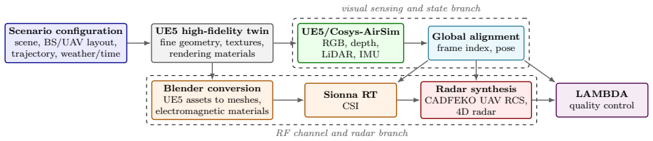
A large digital-twin dataset aligns vision, LiDAR, motion, CSI, and radar for low-altitude UAV sensing and communication under shared trajectories.
Reviewed by Pith at T0; open to challenge. T0 means a machine referee read the full paper against a public rubric. the ladder, T0–T4 →
T0 review · grok-4.5
2026-07-11 23:40 UTC pith:TPLZ5QGE
load-bearing objection Solid, usable low-altitude multimodal ISAC dataset release with real configurability and public code/data; main limit is synthetic RF fidelity without hardware validation, already scoped honestly. the 2 major comments →
LAMBDA: A Low-Altitude Multimodal Base Dataset for UAV Sensing and Communication
The pith
A machine-rendered reading of the paper's core claim, the machinery that carries it, and where it could break.
Core claim
LAMBDA is a high-fidelity, modality-diverse, scenario-rich, and RF-configurable low-altitude multimodal base dataset of 2.04 TB and 517,939 aligned frames whose synchronized visual, geometric, inertial, CSI, and radar records are complete, physically plausible, and directly consumable by UAV ISAC pipelines, as supported by generation-time quality control, weather and multimodal visualizations, and two learning use cases.
What carries the argument
The digital-twin generation pipeline: UE5/Cosys-AirSim for frame-indexed UAV motion and visual/LiDAR/IMU streams; Blender mesh conversion with refined electromagnetic materials into Sionna RT path-level CSI; CADFEKO UAV RCS for configurable FMCW radar synthesis; offline alignment in a shared right-handed world frame by common frame index and realized pose.
Load-bearing premise
That this offline stack of rendering, material-aware ray tracing, UAV radar-cross-section models, and modality-specific weather degradations is realistic and consistent enough that algorithms trained on it can transfer toward real low-altitude base-station-to-UAV systems without matching physical measurements in the same geometries.
What would settle it
Measure real BS–UAV CSI, radar returns, and camera/LiDAR under matched trajectories, weather, and antenna setups in one of the released scenes and check whether synthetic multipath, beam labels, and localization geometry agree closely enough that models trained on LAMBDA retain accuracy when fine-tuned or tested on the hardware data.
Editorial analysis
A structured set of objections, weighed in public.
Referee Report
Summary. The manuscript introduces LAMBDA, a large synthetic digital-twin dataset (2.04 TB, 517,939 aligned frames) for low-altitude UAV integrated sensing and communication (ISAC). It provides synchronized RGB, depth, LiDAR, IMU, UAV poses, path-level CSI, and configurable FMCW radar-synthesis resources under shared frame indices and a unified right-handed world coordinate system. Generation combines UE5/Cosys-AirSim, Blender mesh conversion, refined electromagnetic materials, Sionna RT multipath, and CADFEKO UAV RCS, with modality-specific weather models. Coverage includes urban/suburban/campus scenes, multi-UAV/multi-BS layouts, night, and rain/snow/fog. Reliability is assessed via generation-time quality control, weather and multimodal visualizations, and two usability experiments: RGB-aided 60 GHz beam prediction (with few-shot transfer to DeepSense Scenario 23) and RGB–LiDAR 3D UAV localization across scenes.
Significance. Low-altitude UAV ISAC research has been constrained by the lack of synchronized multimodal records that jointly capture RF propagation, vision, geometry, motion, and weather under common trajectories. LAMBDA is a substantial resource contribution: it is larger and more modality-complete for infrastructure-side low-altitude observation than prior wireless or synthetic-city datasets (Table 1), stores configurable path-level CSI rather than fixed tensors, and releases public data (Science Data Bank DOI) plus code for CSI postprocessing and radar synthesis. The offline pose-centered alignment protocol, multi-stage QC, and non-circular usability checks—including backbone pretraining transfer to a real multimodal dataset—are concrete strengths that make the resource immediately usable for benchmarking and pretraining.
major comments (2)
- Abstract and Background & Summary repeatedly characterize LAMBDA as offering “high physical and visual fidelity,” while Technical Validation assesses reliability mainly via archive/QC checks, qualitative visualizations (Figs. 6–8), and two learning use cases. There is no quantitative comparison of synthetic RF statistics (e.g., path-loss vs range, delay-spread or angular-spread distributions, weather attenuation) against published low-altitude measurement campaigns or standard models. For a dataset paper this is not an internal inconsistency, but the fidelity claim is load-bearing for intended algorithm transfer toward real BS–UAV systems. A short Limitations subsection should state that RF/radar realism is model-based (Sionna RT + ITU/Gunn–East + CADFEKO RCS) without same-geometry hardware validation, and clarify that LAMBDA is positioned as a synthetic base/pretraining resource rather
- Technical Validation, Use Case 1 (RGB-aided beam prediction; Fig. 9): The transfer experiment to DeepSense Scenario 23 is the strongest external check, yet the text only states that LAMBDA Open Ground–pretrained models “converge effectively” and that solid lines outperform ImageNet-only dashed lines. Numerical Top-1/Top-3/Top-5 accuracies (or deltas) at the reported training ratios (N=64…1024) should be given in the main text or a small table so the magnitude of the transfer benefit is assessable without sole reliance on the figure. The protocol (reinitialized heads, fair comparison) is sound; the reporting gap is what needs fixing.
minor comments (7)
- Abstract body text contains a spacing/formatting glitch (“alow-altitudemultimodalbase dataset”); fix for production.
- Use Case 2 heading and related text use “UA V” with an internal space; normalize to “UAV” throughout.
- Table 1 is useful but dense; a one-sentence takeaway in the caption (what unique joint coverage LAMBDA adds vs Multimodal-NF / PML-CellularEye / SynthSoM) would help readers.
- Methods, Trajectory Control: free parameters of z-traj (L, Δℓ, Δh, v) and mobility clip limits are stated; briefly note whether these presets are fixed for all released trajectories or user-reconfigurable in the generator scripts.
- Fig. 6 LiDAR panels use red/blue overlays for missing/weather-induced points—state this encoding explicitly in the figure caption for accessibility.
- Data Records / Usage Notes: path-level CSI fields are listed; a short example of reconstructing an OFDM channel tensor (array size, SCS, bandwidth) in the code README or Usage Notes would lower the barrier for communication users.
- References include several 2025–2026 arXiv/preprint entries; ensure final citation metadata (venue, DOI) is updated at proof stage where available.
Circularity Check
No circularity: dataset release with independent QC, external transfer check, and non-tautological usability experiments.
full rationale
LAMBDA is a synthetic multimodal dataset paper, not a first-principles derivation. Its load-bearing claims are that the digital-twin pipeline produces synchronized, complete, and usable low-altitude ISAC records. Those claims are supported by generation-time integrity checks, cross-modal visualizations, public code/DOI, and two learning use cases that do not reduce to their inputs by construction: (1) RGB-aided beam prediction pretrains a ResNet-50 backbone on LAMBDA Open Ground then few-shot adapts to the external real DeepSense Scenario 23 with reinitialized classification heads, so transfer accuracy is not forced by the LAMBDA labels; (2) RGB–LiDAR localization trains on Block 1 and tests on held-out Square 1, with Success@1m compared against an explicit geometric upper bound that uses ground-truth pixels rather than the model’s own predictions. Path-level CSI and radar synthesis are configurable post-processing of stored multipath geometry and CADFEKO RCS, not fitted targets renamed as predictions. Self-citations are limited to the dataset deposit and standard tooling (UE5, AirSim, Sionna, etc.) and do not import uniqueness theorems or ansatzes that force the central result. No self-definitional loop, fitted-input-as-prediction, or self-citation chain is present.
Axiom & Free-Parameter Ledger
free parameters (4)
- z-traj geometric parameters (L, Δℓ, Δh, v)
- random-trajectory mobility limits
- reference FMCW radar preset
- local Niagara emitter volume and spawn rates
axioms (5)
- domain assumption Sionna RT multipath geometry plus frequency-dependent materials and ITU/Gunn–East atmospheric attenuation adequately represent low-altitude BS–UAV channels for algorithm research.
- domain assumption Frame-indexed realized UAV poses in a unified right-handed world frame suffice for offline spatiotemporal alignment of all modalities.
- domain assumption CADFEKO RCS of the AirSim UAV model, queried by attitude, is an adequate radar target model when combined with path-level CSI.
- domain assumption Modality-specific weather degradations (Niagara, LISA, UE5 volumetric fog, Hahner fog model, ITU rain/fog) produce mutually consistent adverse-weather labels.
- standard math Standard computer-graphics and ray-tracing mathematics (coordinate transforms, path gains/delays/angles, FMCW dechirp/FFT processing) hold as implemented.
Cite this review
Pith. "Pith review of LAMBDA: A Low-Altitude Multimodal Base Dataset for UAV Sensing and Communication." pith.science (2026). https://pith.science/paper/TPLZ5QGE
@misc{pith2026260703826,
  author       = {Pith},
  title        = {Pith review of: LAMBDA: A Low-Altitude Multimodal Base Dataset for UAV Sensing and Communication},
  year         = {2026},
  howpublished = {\url{https://pith.science/paper/TPLZ5QGE}},
  note         = {Machine review of arXiv:2607.03826}
}
read the original abstract
Research on low-altitude integrated sensing and communication (ISAC) requires aligned multimodal data that jointly describe wireless propagation, visual appearance, unmanned aerial vehicle (UAV) motion, light detection and ranging (LiDAR) perception, and radar sensing under common trajectories and timestamps. To address this need, a low-altitude multimodal base dataset, named LAMBDA, is introduced. LAMBDA is characterized by high fidelity, modality diversity, scenario richness, and configuration flexibility. It is generated through a high-fidelity digital-twin pipeline with detailed scene geometry, refined material assignment, and electromagnetic modeling of UAVs. LAMBDA provides synchronized RGB images, depth maps, LiDAR point clouds, inertial measurement unit states, UAV poses, channel state information (CSI), and radar-synthesis resources across matched low-altitude operating conditions, shared coordinate systems, and synchronized frame indices. The dataset covers urban, suburban, and campus scenes, multi-UAV/multi-base-station settings, nighttime conditions, and sunny, rainy, snowy, and foggy weather variations. Its CSI and radar resources support user-defined antenna-array sizes, bandwidths, subcarrier spacings, chirp parameters, and plane-wave or spherical-wavefront channel synthesis. The reliability and usability of LAMBDA are assessed through quality control, weather and multimodal visualization, and two UAV ISAC-related use cases: RGB-aided beam prediction and RGB-LiDAR-based UAV localization.
Figures


Forward citations
Cited by 1 Pith paper
-
BDFlow-3DRM: Height-Coherent 3D Radio Map Construction via Bi-Dynamical Flow Matching
A bi-dynamical flow-matching model constructs height-coherent 3D radio maps from environment and transceiver heights, improving accuracy and height generalization while cutting inference cost versus diffusion baselines.
Reference graph
Works this paper leans on
-
[1]
Mohammad Mozaffari, Walid Saad, Mehdi Bennis, Young-Han Nam, and M´ erouane Debbah. A tutorial on UAVs for wireless networks: Applications, challenges, and open problems.IEEE Communications Surveys & Tutorials, 21(3):2334–2360, 2019.https://doi.org/10.1109/ COMST.2019.2902862
arXiv 2019
-
[2]
Heung-Yeung Shum and Shipeng Li. Low-altitude economy: next frontier in spatial exploration and economic development.National Science Review, 13(12):nwag208, June 2026.https: //doi.org/10.1093/nsr/nwag208
-
[3]
Fan Liu, Yuanhao Cui, Christos Masouros, Jie Xu, Tony Xiao Han, Yonina C. Eldar, and Ste- fano Buzzi. Integrated sensing and communications: Towards dual-functional wireless networks for 6G and beyond.IEEE Journal on Selected Areas in Communications, 40(6):1728–1767, 2022.https://doi.org/10.1109/JSAC.2022.3156632
-
[4]
Yihang Jiang, Xiaoyang Li, Guangxu Zhu, Hang Li, Jing Deng, Kaifeng Han, Chao Shen, Qingjiang Shi, and Rui Zhang. Integrated sensing and communication for low altitude economy: Opportunities and challenges.IEEE Communications Magazine, 63(12):72–78, 2025.https: //doi.org/10.1109/MCOM.001.2400685
-
[5]
An overview of cellular ISAC for low-altitude UAV: New opportunities and challenges.IEEE Communications Magazine, 63(12):88–95, 2025.https://doi.org/10
Yuxuan Song, Yong Zeng, Yuhang Yang, Zixiang Ren, Gaoyuan Cheng, Xiaoli Xu, Jie Xu, Shi Jin, and Rui Zhang. An overview of cellular ISAC for low-altitude UAV: New opportunities and challenges.IEEE Communications Magazine, 63(12):88–95, 2025.https://doi.org/10. 1109/MCOM.002.2400742
2025
-
[6]
Framework and overall objectives of the future development of IMT for 2030 and beyond
ITU-R. Framework and overall objectives of the future development of IMT for 2030 and beyond. Recommendation ITU-R M.2160-0, International Telecommunication Union, 2023. https://www.itu.int/rec/R-REC-M.2160-0-202311-I/en
2030
-
[7]
Mohamed-Slim Alouini, Emil Bj¨ ornson, Meixia Tao, and Yasamin Mostofi. The road to 6G: Driving the next wave of connectivity—Part I [Scanning the Issue].Proceedings of the IEEE, 112(7):615–620, 2024.https://doi.org/10.1109/JPROC.2024.3475891
-
[8]
Are we ready for autonomous driving? The KITTI vision benchmark suite
Andreas Geiger, Philip Lenz, and Raquel Urtasun. Are we ready for autonomous driving? The KITTI vision benchmark suite. InProceedings of the IEEE Conference on Computer Vision and Pattern Recognition, pages 3354–3361, 2012.https://doi.org/10.1109/CVPR. 2012.6248074. 17
doi:10.1109/cvpr 2012
-
[9]
Runsheng Xu, Hao Xiang, Zhengzhong Tu, Xin Xia, Ming-Hsuan Yang, and Jiaqi Ma. OPV2V: An open benchmark dataset and fusion pipeline for perception with vehicle-to-vehicle commu- nication. InProceedings of the IEEE International Conference on Robotics and Automation, pages 2583–2589, 2022.https://doi.org/10.1109/ICRA46639.2022.9812038
-
[10]
DAIR-V2X: A large-scale dataset for vehicle- infrastructure cooperative 3D object detection
Haibao Yu, Yizhen Luo, Mao Shu, Yiyi Huo, Zebang Yang, Yifeng Shi, Zhenglong Guo, Hanyu Li, Xing Hu, Jirui Yuan, and Zaiqing Nie. DAIR-V2X: A large-scale dataset for vehicle- infrastructure cooperative 3D object detection. InProceedings of the IEEE/CVF Conference on Computer Vision and Pattern Recognition, pages 21329–21338, 2022.https://doi.org/ 10.1109/...
-
[11]
A synthetic digital city dataset for robustness and generalisation of depth esti- mation models.Sci
Jihao Li, Jincheng Hu, Yanjun Huang, Zheng Chen, Jingjing Jiang, Yuanjian Zhang, and Bingzhao Gao. A synthetic digital city dataset for robustness and generalisation of depth esti- mation models.Sci. Data, 11:301, 2024.https://doi.org/10.1038/s41597-024-03025-5
-
[12]
DeepMIMO: A generic deep learning dataset for millimeter wave and mas- sive MIMO applications
Ahmed Alkhateeb. DeepMIMO: A generic deep learning dataset for millimeter wave and mas- sive MIMO applications. InProceedings of the Information Theory and Applications Workshop, 2019.https://doi.org/10.48550/arXiv.1902.06435
-
[13]
WAIR-D: Wireless AI research dataset
Yourui Huangfu, Jian Wang, Shengchen Dai, Rong Li, Jun Wang, Chongwen Huang, and Zhaoyang Zhang. WAIR-D: Wireless AI research dataset. InProceedings of the IEEE/CIC International Conference on Communications in China, pages 43–48, 2022
2022
-
[14]
ViWi: A deep learning dataset framework for vision-aided wireless communications
Muhammad Alrabeiah, Andrew Hredzak, Zhenhao Liu, and Ahmed Alkhateeb. ViWi: A deep learning dataset framework for vision-aided wireless communications. In2020 IEEE 91st Vehicular Technology Conference (VTC2020-Spring), pages 1–5. IEEE, 2020.https: //doi.org/10.1109/VTC2020-Spring48590.2020.9128579
-
[15]
Jerry Gu, Batool Salehi, Debashri Roy, and Kaushik R. Chowdhury. Multimodality in mmWave MIMO beam selection using deep learning: Datasets and challenges.IEEE Communications Magazine, 60(11):36–41, 2022.https://doi.org/10.1109/MCOM.002.2200028
-
[16]
Ahmed Alkhateeb et al. DeepSense 6G: A large-scale real-world multi-modal sensing and communication dataset.IEEE Communications Magazine, 61(9):122–128, 2023.https:// doi.org/10.1109/MCOM.006.2200730
-
[17]
Xiang Cheng, Ziwei Huang, Lu Bai, Haotian Zhang, Mingran Sun, Boxun Liu, Sijiang Li, Jianan Zhang, and Minson Lee. M3SC: A generic dataset for mixed multi-modal sensing and communication integration.China Communications, 20(11):13–29, 2023.https://doi.org/ 10.23919/JCC.fa.2023-0268.202311
-
[18]
SynthSoM: A synthetic intelligent multi-modal sensing-communication dataset for synesthesia of machines (SoM).Sci
Xiang Cheng, Ziwei Huang, Yong Yu, Lu Bai, Mingran Sun, Zengrui Han, Ruide Zhang, and Sijiang Li. SynthSoM: A synthetic intelligent multi-modal sensing-communication dataset for synesthesia of machines (SoM).Sci. Data, 12:819, 2025.https://doi.org/10.1038/ s41597-025-05065-x
2025
-
[19]
DeepVerse 6G and WI-Lab dataset collection.https://www
Wireless Intelligence Lab. DeepVerse 6G and WI-Lab dataset collection.https://www. wi-lab.net/datasets-page/, 2025. 18
2025
-
[20]
Tianhao Mao, Le Liang, Jie Yang, Hao Ye, Shi Jin, and Geoffrey Ye Li. Multimodal-Wireless: A large-scale dataset for sensing and communication.arXiv preprint arXiv:2511.03220, 2025. https://arxiv.org/abs/2511.03220
arXiv 2025
-
[21]
Mengyuan Li, Qianfan Lu, Jiachen Tian, Hongjun Hu, Yu Han, Xiao Li, Chao-Kai Wen, and Shi Jin. Multimodal-NF: A wireless dataset for near-field low-altitude sensing and communi- cations.arXiv preprint arXiv:2603.28280, 2026.https://doi.org/10.48550/arXiv.2603. 28280
-
[22]
PML-CellularEye: A multi-modal experimental dataset for 6G ISAC re- search.Science China Information Sciences, 69(6):167301, 2026.https://doi.org/10.1007/ s11432-026-4923-1
Ziguo Zhong, Yongming Huang, Huazhou Hou, Fanfei Xu, Haisheng Feng, Shengheng Liu, and Xiaohu You. PML-CellularEye: A multi-modal experimental dataset for 6G ISAC re- search.Science China Information Sciences, 69(6):167301, 2026.https://doi.org/10.1007/ s11432-026-4923-1
2026
-
[23]
Unreal Engine 5.https://www.unrealengine.com/
Epic Games. Unreal Engine 5.https://www.unrealengine.com/
-
[24]
AirSim: High-fidelity visual and physical simulation for autonomous vehicles
Shital Shah, Debadeepta Dey, Chris Lovett, and Ashish Kapoor. AirSim: High-fidelity visual and physical simulation for autonomous vehicles. InField and Service Robotics: Results of the 11th International Conference, pages 621–635. Springer, 2018.https://doi.org/10.1007/ 978-3-319-67361-5_40
2018
-
[25]
Cosys-AirSim: Extended AirSim simulation for autonomous mobility systems
Cosys-Lab. Cosys-AirSim: Extended AirSim simulation for autonomous mobility systems. https://cosys-lab.github.io/Cosys-AirSim/
-
[26]
Blender.https://www.blender.org/
Blender Foundation. Blender.https://www.blender.org/
-
[27]
Sionna RT: Technical report, 2025
Fay¸ cal Ait Aoudia, Jakob Hoydis, Merlin Nimier-David, Sebastian Cammerer, and Alex Keller. Sionna RT: Technical report, 2025
2025
-
[28]
Altair Feko: High-frequency electromagnetic simulation software
Altair Engineering Inc. Altair Feko: High-frequency electromagnetic simulation software. https://altair.com/feko
-
[29]
Rong Li and Vesselin P
X. Rong Li and Vesselin P. Jilkov. Survey of maneuvering target tracking. Part I: Dynamic models.IEEE Transactions on Aerospace and Electronic Systems, 39(4):1333–1364, October 2003
2003
-
[30]
Velat Kilic, Deepti Hegde, Vishwanath Sindagi, A. Brinton Cooper, Mark A. Foster, and Vishal M. Patel. LiDAR light scattering augmentation (LISA): Physics-based simulation of adverse weather conditions for 3D object detection. InICASSP 2025 - 2025 IEEE International Conference on Acoustics, Speech and Signal Processing (ICASSP), pages 1–5, 2025.https: //d...
-
[31]
Fog simulation on real LiDAR point clouds for 3D object detection in adverse weather
Martin Hahner, Christos Sakaridis, Dengxin Dai, and Luc Van Gool. Fog simulation on real LiDAR point clouds for 3D object detection in adverse weather. InProceedings of the IEEE/CVF International Conference on Computer Vision (ICCV), pages 15263–15272, 2021. https://doi.org/10.1109/ICCV48922.2021.01500
-
[32]
LAMBDA: A low-altitude multimodal base dataset for UAV sensing and communication
Lin Zhou, Peichuan Rao, Chenshuo Zhang, Jianhua Mo, Shu Sun, Zhiyong Chen, and Meixia Tao. LAMBDA: A low-altitude multimodal base dataset for UAV sensing and communication. Science Data Bank, 2026.https://doi.org/10.57760/sciencedb.36052. 19
-
[33]
Specific attenuation model for rain for use in prediction methods
ITU-R. Specific attenuation model for rain for use in prediction methods. Recommendation ITU-R P.838-3, International Telecommunication Union, 2005
2005
-
[34]
Attenuation due to clouds and fog
ITU-R. Attenuation due to clouds and fog. Recommendation ITU-R P.840-9, International Telecommunication Union, 2024
2024
-
[35]
K. L. S. Gunn and T. W. R. East. The microwave properties of precipitation parti- cles.Quarterly Journal of the Royal Meteorological Society, 80(346):522–545, 1954.https: //doi.org/10.1002/qj.49708034603
-
[36]
Gopala K. Charan, Ammar Hredzak, Christopher Stoddard, Mustafa Al-Sabah, Jaspreet Chourasia, and Ahmed Alkhateeb. Towards real-world 6G drone communication: Position and camera aided beam prediction. InProceedings of the IEEE Global Communications Con- ference (GLOBECOM), pages 2951–2956, 2022.https://doi.org/10.1109/GLOBECOM48099. 2022.10000718. Acknowle...
discussion (0)
Sign in with ORCID, Apple, or X to comment. Anyone can read and Pith papers without signing in.