REVIEW 4 major objections 5 minor 73 references
KRAFT: A Knowledge Graph-Based Framework for Automated Map Conflation
T0 review · 4 major / 5 minor · reviewed 2026-08-15 · deepseek-v4-flash
Pith's one-line read This paper claims that representing two maps as knowledge graphs, learning entity embeddings with a gated multi-hop graph encoder, and merging unmatched entities through a mixed-integer linear program makes map conflation both more…
desk verdict KRAFT is a genuinely new learned pipeline for map conflation that handles buildings as well as roads, but its 'outperforms state-of-the-art' claim currently rests on an inferred Hootenanny baseline that needs an actual run. read the letter →
The pith
A machine-rendered reading of the paper's core claim, the machinery that carries it, and where it could break.
The reading
What carries the argument
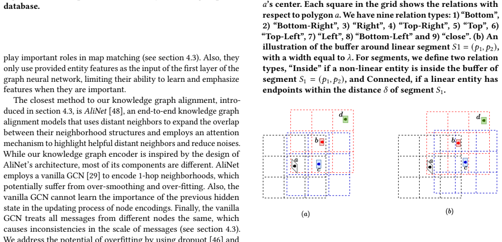
The load-bearing mechanism is the map-as-knowledge-graph construction followed by a two-stream graph encoder and a merging MILP. Non-linear entities receive a 3x3 grid of directional relations, while linear segments receive buffer-based Inside and Connected relations. A 1-hop GNN preserves local structure, a multi-hop graph attention encoder weights distant neighbors, and an MLP-Mixer encodes cross-feature metadata; a gated combination plus a relation-semantics loss produces entity embeddings that are matched by maximum-weight bipartite matching. For merging, the epsilon-shift operation generalizes translation and resizing of axis-aligned rectangles, and three overlap cases are encoded as mixed-integer linear constraints whose objective minimizes the sum of absolute shifts, with a shape-preserving weight.
What would settle it
Run KRAFT's merging on a dataset whose buildings are rotated 45 degrees relative to the x and y axes, reconstruct the true footprints, and measure pairwise intersections: any nonzero overlap would refute the zero-additional-inconsistency claim. Appendix H.3 predicts such a failure, since axis-aligned bounding rectangles create nonfunctioning space around rotated objects.
Extended reading notes
Core claim
On the paper's own terms, the discovery is that treating a map as a knowledge graph unlocks a data-driven conflation pipeline that beats MAYUR, Hootenanny, Jaccard similarity, rubbersheeting, and position-based merging on both linear and non-linear objects. Matching works because the knowledge graph captures relative positions of neighbors, the 1-hop and multi-hop encoders recover connections broken by positional noise, and a learned gate combines structural and metadata signals. Merging works because every object is approximated as an axis-aligned minimum bounding rectangle, reducing overlap removal to linear constraints over epsilon-shift variables that move, resize, and recenter unmatched objects while minimizing total perturbation. The zero-new-inconsistency result is presented as a guarantee of the MILP formulation, not merely as an empirical improvement.
Load-bearing premise
The load-bearing premise is that every object can be treated as an axis-aligned minimum bounding rectangle for the purpose of guaranteeing a consistent merge; if true footprints overlap outside those rectangles, the promised no-inconsistency outcome does not follow.
Editorial extensions
If this is right
- If the central claim holds, map conflation no longer needs separate algorithms for roads and buildings; one learned pipeline can match both object classes.
- Data-driven matching should transfer to new cities with different discrepancy patterns, because similarity is learned rather than thresholded by hand.
- The MILP merging formulation offers a guarantee of no newly overlapping minimum-bounding rectangles, which is directly relevant for navigation and parcel-level map updates.
- On OSM-BOD the reported numbers are near saturation (sidewalk recall 0.997, building precision 0.958), so future comparisons will need harder datasets or heterogeneous geometric representations to show further gains.
Reading between the lines
- The no-inconsistency guarantee is proved for axis-aligned minimum bounding rectangles, not true building footprints; Appendix H.3 concedes that rotated objects leave nonfunctioning space, so the strongest version of the claim should be tested on rotated geometries.
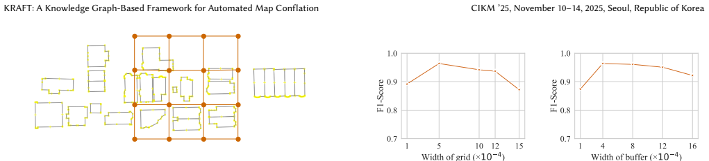
- Fixed grid and buffer widths are likely to become a bottleneck in cities with very different densities; the paper lists adaptive sizing as future work, and the attention mechanism only partially compensates.
- The same structural-plus-metadata encoding could plausibly align other noisy spatial entity sets, such as indoor floor plans or cadastral parcels, though the paper does not test these.
- Training relies on ground-truth aligned pairs, so deployment on a new unlabeled region would require a weakly supervised or self-supervised variant that the paper does not provide.
Signed reviews
Editorial analysis
A structured set of objections, weighed in public.
Referee Report
Summary. The paper proposes KRAFT, a three-module map-conflation framework. It represents each vector GDB as a knowledge graph whose nodes are linear and non-linear entities and whose edges encode directional grid relations and buffer/connectivity relations; it then learns entity embeddings with a 1-hop GNN, a 2-hop attention module, an MLP-Mixer feature encoder, and a gated combination, trained with a contrastive plus relation-semantics loss. Matching is solved as max-weight bipartite matching. Unmatched target entities are merged into an immutable source via a MILP that epsilon-shifts/resizes axis-aligned minimum bounding rectangles to avoid overlaps while minimizing total perturbation. Experiments on OSM and Boston Open Data report precision/recall for sidewalk, building, and overall matching, plus CNI and perturbation metrics for merging, with ablations in the appendix.
Significance. If the claims were fully supported, KRAFT would be a meaningful step beyond road-only, heuristic conflation: it explicitly handles non-linear entities, learns matching from data, and formulates merging as an optimization with formal linear-inequality encodings. The paper's strengths include a modular design, explicit complexity analysis of KG construction and matching, and appendix proofs (Lemmas 1-4, Proposition 1) for the MILP encoding. However, the current evidence does not yet establish the headline claim: the state-of-the-art comparison rests on an inferred Hootenanny baseline, the inconsistency guarantee is stated for MBR proxies, and evaluation lacks variance reporting. With these gaps closed, the framework would be a solid contribution to CIKM.
major comments (4)
- [Section 5, Baselines; Table 2] The Hootenanny row in Table 2 (and the Hootenanny column in Table 3) is not measured: the text states 'Since we lack access to Hootenanny's map matching results, we infer missing and incorrect matches based on duplicate and disoriented geometries.' Because the abstract's headline claim is that KRAFT outperforms state-of-the-art methods, and Hootenanny is the only competitor that also handles both buildings and sidewalks in the overall map-matching row, an inferred baseline cannot support that claim. Please run the actual Hootenanny pipeline on the same OSM-BOD data, or, if that is not possible, remove Hootenanny from the SOTA comparison and explicitly restrict the superiority claim to the measured baselines (MAYUR and Jaccard).
- [Section 4.4 and Appendix H.3] The 'no inconsistencies' guarantee is proved only for axis-aligned minimum bounding rectangles, not for the actual object geometries. While a polygon is contained in its MBR, so disjoint MBRs imply disjoint polygons, the paper never specifies how an epsilon-shift of the MBR (including side-by-side resizing) is transported back to the original polygon when the MILP solution is applied; Appendix H.3 itself concedes that axis-aligned MBRs 'can cause nonfunctioning space around objects that are not parallel to the x and y axes.' Please specify the geometry transformation used at merge time and restate the guarantee as 'no additional MBR overlaps' or prove the analogous statement for the transformed original shapes.
- [Section 5, Experimental Setup; Tables 2, 3, 6] No standard deviations, confidence intervals, or repeated-run statistics are reported for any of the matching or merging metrics. The precision gaps over MAYUR (0.988 vs 0.981 on sidewalks) are small, and without variance information or a description of the test split beyond the 100-building/100-segment validation set, it is impossible to judge whether the reported improvements are statistically meaningful. Please report mean and variance over multiple data splits or runs and specify exactly which entities are used for training, validation, and testing.
- [Section 4.3, Equations (8)-(10) and Algorithm 2] The relation-semantics loss is under-specified: Equation (8) defines Θ_r as the average of h_e - h_e' over triples, and then Equation (9) minimizes the deviation of each residual from that same average, so the objective is essentially a variance term; moreover Algorithm 2 computes separate Θ^s_r and Θ^t_r for the source and target graphs but the loss in Equation (10) is written with a single Θ_r, leaving unclear how relation semantics are shared or aligned across the two GDBs. Please clarify the exact objective (including whether Θ_r is treated as a constant or differentiated through) and justify why this loss enforces the intended cross-GDB alignment.
minor comments (5)
- [Definition 7] The matching definition uses a threshold 𝒮 that never appears in the later optimization (Equation 12); please clarify whether the threshold is part of the formal problem or only an informal illustration.
- [Section 1, Introduction] There is a typo in the sentence 'these methods are are time-consuming and not scalable'; the duplicate 'are' should be removed.
- [Algorithm 1] The grid-relation conditions use strict inequalities, so entities lying exactly on a grid boundary are not assigned any relation; please state how ties are broken.
- [Appendix F.1, Case 2] In the second displayed implication of Case 2, the expression 'a'_2+\varepsilon^x_2\varepsilon^x_c' is missing a '+' between the two epsilon terms.
- [Appendix G.1] The text refers to 'Bosten datasets'; this should be 'Boston datasets'.
Circularity Check
Minor self-referential relation-semantics loss; central matching and merging claims remain independent of the fitted parameters.
-
self definitional
[Section 4.3, Equations 8–9 (Training and Loss Function)]
"for a relation r∈R we consider its encoding, Θ_r, as the average of the differences between its related entity embeddings: Θ_r = 1/|T_r| Σ_{(e,r,e')∈T} (h_e−h_e'), ... Next, we use the following relation loss for refinement: L_semantics = Σ_{r∈R} 1/|T_r| Σ_{(e,r,e')∈T} ||h_e−h_e'−Θ_r||."
Θ_r is not an independently defined relation vector: it is the arithmetic mean of the same differences h_e−h_e' over exactly the same triples that Equation 9 penalizes. The semantic loss therefore mostly reduces the scatter of h_e−h_e' around their own average rather than fitting the encodings to an externally supplied relation semantics. In this narrow sense the target of the penalty is a function of the penalized variables, so the step is self-referential by construction. This does not undermine the central matching claim, because the matching model is evaluated on held-out ground-truth correspondences and the relation loss is only one auxiliary component; the ablation shows it is a useful regularizer, not a disguised prediction of the reported precision/recall.
full rationale
The core derivation chain of KRAFT is otherwise self-contained and benchmarked against held-out correspondences. The map matching module is trained with ground-truth aligned pairs and evaluated on precision/recall, so the headline matching numbers are not fitted values renamed as predictions. The map merging MILP is constructed from explicit overlap-avoidance inequalities and solved with standard solvers; the MBR approximation is a geometric gap that may weaken the “no inconsistencies” guarantee for non-axis-aligned shapes, but it is not circular. MAYUR is a baseline, not a load-bearing input, even though one of its authors is a co-author of KRAFT; the paper does not invoke MAYUR to justify KRAFT's design or to forbid alternatives. The Hootenanny comparison is weakened because the paper says it “infer[s] missing and incorrect matches” without access to Hootenanny's results, but that is an experimental-validity concern rather than a circular derivation. The only genuinely self-referential construction is the relation-semantics loss in Equations 8–9, where the relation encoding is the mean of the very differences the loss constrains; this is a minor, local circularity and does not by itself force the paper's main empirical conclusions.
Assumptions & free parameters
free parameters (6)
- Grid width mu =
approximately 100 m (5e-4 in map units)
- Buffer width lambda =
selected from interval 1e-4 to 8e-4 in map units; exact value not reported
- Similarity mixing weight tau =
0.5
- Merging shape-vs-shift weight gamma =
2.1
- Contrastive margin and loss weights =
grid-searched over beta in {0.1,0.2,0.4,0.8}, alpha in {0.005,...,0.2}, margin in {0.6,...,2}; best values not reported
- Terminal point angle threshold theta =
45 degrees (pi/4 rad)
assumptions (5)
- domain assumption Source GDB is immutable and provides broader coverage than target; conflated map is a copy of source with unmatched target entities added.
- domain assumption A set of pre-aligned entity pairs A+ is available for supervised training.
- ad hoc to paper A fixed 3x3 grid of width mu around each non-linear entity and a buffer of width lambda around each linear segment captures the neighborhoods needed for matching.
- ad hoc to paper Every object can be approximated by an axis-aligned minimum bounding rectangle for merging, and overlap avoidance on these rectangles yields a consistent map.
- domain assumption Negative samples for contrastive loss are generated by randomly replacing one entity in each aligned pair.
Cite this review
Pith. "Pith review of KRAFT: A Knowledge Graph-Based Framework for Automated Map Conflation." pith.science (2026). https://pith.science/paper/TRIOJZR2
@misc{pith2026250904684,
  author       = {Pith},
  title        = {Pith review of: KRAFT: A Knowledge Graph-Based Framework for Automated Map Conflation},
  year         = {2026},
  howpublished = {\url{https://pith.science/paper/TRIOJZR2}},
  note         = {Machine review of arXiv:2509.04684}
}
read the original abstract
Digital maps play a crucial role in various applications such as navigation, fleet management, and ride-sharing, necessitating their accuracy and currency, which require timely updates. While the majority of geospatial databases (GDBs) provide high-quality information, their data is (i) limited to specific regions and/or (ii) missing some entities, even in their covered areas. Map conflation is the process of augmentation of a GDB using another GDB to conflate missing spatial features. Existing map conflation methods suffer from two main limitations: (1) They are designed for the conflation of linear objects (e.g., road networks) and cannot simply be extended to non-linear objects, thus missing information about most entities in the map. (2) They are heuristic algorithmic approaches that are based on pre-defined rules, unable to learn entities matching in a data-driven manner. To address these limitations, we design KRAFT, a learning based approach consisting of three parts: (1) Knowledge Graph Construction - where each GDB is represented by a knowledge graph, (2) Map Matching - where we use a knowledge graph alignment method as well as a geospatial feature encoder to match entities in obtained knowledge graphs, and (3) Map Merging - where we merge matched entities in the previous modules in a consistent manner, using a mixed integer linear programming formulation that fully merges the GDBs without adding any inconsistencies. Our experimental evaluation shows that not only does KRAFT achieve outstanding performance compared to state-of-the-art and baseline methods in map conflation tasks, but each of its modules (e.g., Map Matching and Map Merging) also separately outperforms traditional matching and merging methods.
Figures


Figures from the paper (7 more)




Reference graph
Works this paper leans on
-
[1]
2021.A principled approach to automated road network confla- tion
Gorisha Agarwal. 2021.A principled approach to automated road network confla- tion. Master’s thesis. University of British Columbia. doi:10.14288/1.0398182
-
[2]
Gorisha Agarwal, Laks VS Lakshmanan, Xiaoming Gao, Kevin Ventullo, Saurav Mohapatra, and Saikat Basu. 2021. MAYUR: Map conflAtion using earlY prUning and Rank join. InProceedings of the 29th International Conference on Advances in Geographic Information Systems. 550–553
work page 2021
-
[3]
Gibran Ali, Neal Feierabend, Prarthana Doshi, Whoibin Chung, Simona Babiceanu, and Michael Fontaine. 2025. Automated Route-based Conflation Between Linear Referencing System Maps And OpenStreetMap Using Open- source Tools.arXiv preprint arXiv:2507.13939(2025)
work page Pith review arXiv 2025
-
[4]
Mousa Almotairi, Tariq Alsahfi, and Ramez Elmasri. 2018. Using Local and Global Divergence Measures to Identify Road Similarity in Different Road Network Datasets. InProceedings of the 11th ACM SIGSPATIAL International Workshop on Computational Transportation Science. 21–28
work page 2018
-
[5]
Logan Beal, Daniel Hill, R Martin, and John Hedengren. 2018. GEKKO Optimiza- tion Suite.Processes6, 8 (2018), 106. doi:10.3390/pr6080106
-
[6]
Ali Behrouz and Farnoosh Hashemi. 2024. Graph mamba: Towards learning on graphs with state space models. InProceedings of the 30th ACM SIGKDD conference on knowledge discovery and data mining. 119–130
work page 2024
-
[7]
Ali Behrouz, Zeman Li, Praneeth Kacham, Majid Daliri, Yuan Deng, Peilin Zhong, Meisam Razaviyayn, and Vahab Mirrokni. 2025. Atlas: Learning to optimally memorize the context at test time.arXiv preprint arXiv:2505.23735(2025)
arXiv 2025
-
[8]
Ali Behrouz, Meisam Razaviyayn, Peilin Zhong, and Vahab Mirrokni. 2025. It’s All Connected: A Journey Through Test-Time Memorization, Attentional Bias, Retention, and Online Optimization.arXiv preprint arXiv:2504.13173(2025)
arXiv 2025
Show all 73 references
-
[9]
Ali Behrouz, Peilin Zhong, and Vahab Mirrokni. 2024. Titans: Learning to memo- rize at test time.arXiv preprint arXiv:2501.00663(2024)
2024 arXiv
-
[10]
Antoine Bordes, Nicolas Usunier, Alberto Garcia-Duran, Jason Weston, and Ok- sana Yakhnenko. 2013. Translating Embeddings for Modeling Multi-relational Data. InAdvances in Neural Information Processing Systems, C.J. Burges, L. Bot- tou, M. Welling, Z. Ghahramani, and K.Q. Wein...
2013
-
[11]
Michael M Bronstein, Joan Bruna, Taco Cohen, and Petar Veličković. 2021. Geo- metric deep learning: Grids, groups, graphs, geodesics, and gauges.arXiv preprint arXiv:2104.13478(2021)
2021 arXiv
-
[12]
Roberto Canavosio-Zuzelski, Jason Surratt, Drew Bower, Joseph Governski, and Matthew Sorenson. 2015. Hootenanny Github. https://github.com/ngageoint/ hootenanny
2015
-
[13]
Roberto Canavosio-Zuzelski, Jason Surratt, Drew Bower, Joseph Governski, and Matthew Sorenson. 2015. Hootenanny: web enabeled geospatial vector-data con- flation and map generation. InProceedings of the 2015 Annual ASPRS Conference. ASPRS Tampa, FL
2015
-
[14]
Knoblock
Ching-Chien Chen and Craig A. Knoblock. 2008.Conflation of Geospatial Data. Springer US, Boston, MA, 133–140. doi:10.1007/978-0-387-35973-1_182
2008 doi
-
[15]
Ching-Chien Chen, Craig A Knoblock, and Cyrus Shahabi. 2006. Automatically conflating road vector data with orthoimagery.GeoInformatica10 (2006), 495– 530
2006
-
[16]
Zihang Dai, Zhilin Yang, Yiming Yang, Jaime Carbonell, Quoc V Le, and Ruslan Salakhutdinov. 2019. Transformer-xl: Attentive language models beyond a fixed- length context.arXiv preprint arXiv:1901.02860(2019)
2019 arXiv
-
[17]
Austin Derrow-Pinion, Jennifer She, David Wong, Oliver Lange, Todd Hester, Luis Perez, Marc Nunkesser, Seongjae Lee, Xueying Guo, Brett Wiltshire, et al
-
[18]
Lingbing Guo, Zequn Sun, and Wei Hu. 2019. Learning to exploit long-term relational dependencies in knowledge graphs. InInternational conference on machine learning. PMLR, 2505–2514
2019
-
[19]
Antonin Guttman. 1984. R-trees: A dynamic index structure for spatial searching. InProceedings of the 1984 ACM SIGMOD international conference on Management of data. 47–57
1984
-
[20]
Muki Haklay. 2010. How Good is Volunteered Geographical Information? A Com- parative Study of OpenStreetMap and Ordnance Survey Datasets.Environment and Planning B: Planning and Design37, 4 (2010), 682–703. doi:10.1068/b35097
2010 doi
-
[21]
Lars E Harrie. 1999. The constraint method for solving spatial conflicts in cartographic generalization.Cartography and geographic information science26, 1 (1999), 55–69
1999
-
[22]
Jan-Henrik Haunert. 2005. Link based conflation of geographic datasets. InICA Workshop on Generalisation and Multiple Representation, Vol. 7
2005
-
[23]
Dan Hendrycks and Kevin Gimpel. 2020. Gaussian Error Linear Units (GELUs). arXiv:1606.08415 [cs.LG]
2020 arXiv
-
[24]
Benjamin Herfort, Sven Lautenbach, Jéssica Porto de Albuquerque, Jonny An- derson, Michael Eckle, and Alexander Zipf. 2023. A spatio-temporal analysis investigating completeness and inequalities of global urban building data in OpenStreetMap.Nature Communications14, 1 (2023), ...
2023 doi
-
[25]
Sven Hertling, Jan Portisch, and Heiko Paulheim. 2021. Matching with trans- formers in MELT.arXiv preprint arXiv:2109.07401(2021)
2021 arXiv
-
[26]
Jilin Hu, Bin Yang, Chenjuan Guo, Christian S Jensen, and Hui Xiong. 2020. Stochastic origin-destination matrix forecasting using dual-stage graph convolu- tional, recurrent neural networks. In2020 IEEE 36th International conference on data engineering (ICDE). IEEE, 1417–1428
2020
-
[27]
Yaron Katzil and Yerach Doytsher. 2005. Spatial rubber sheeting of DTMs. In Proceedings of the 6th Geomatic Week Conference, Barcelona, Spain, Vol. 811
2005
-
[28]
Seyed Mehran Kazemi and David Poole. 2018. Simple embedding for link predic- tion in knowledge graphs.Advances in neural information processing systems31 (2018)
2018
-
[29]
Kipf and Max Welling
Thomas N. Kipf and Max Welling. 2017. Semi-Supervised Classification with Graph Convolutional Networks. InInternational Conference on Learning Repre- sentations. https://openreview.net/forum?id=SJU4ayYgl
2017
-
[30]
Ting Lei and Zhen Lei. 2019. Optimal spatial data matching for conflation: A network flow-based approach.Transactions in GIS23, 5 (2019), 1152–1176
2019
-
[31]
Maximilian Leitenstern, Florian Sauerbeck, Dominik Kulmer, and Johannes Betz
-
[32]
Linna Li and Michael F Goodchild. 2010. Optimized feature matching in conflation. InGeographic information science: 6th international conference, GIScience. 14–17
2010
-
[33]
Linna Li and Michael F Goodchild. 2011. An optimisation model for linear feature matching in geographical data conflation.International Journal of Image and Data Fusion2, 4 (2011), 309–328
2011
-
[34]
Changyong Liu, Lian Xiong, Xiangyun Hu, and Jie Shan. 2015. A progressive buffering method for road map update using OpenStreetMap data.ISPRS Interna- tional Journal of Geo-Information4, 3 (2015), 1246–1264
2015
-
[35]
Zhiyuan Liu, Yixin Cao, Liangming Pan, Juanzi Li, and Tat-Seng Chua. 2020. Exploring and evaluating attributes, values, and structures for entity alignment. arXiv preprint arXiv:2010.03249(2020)
2020
-
[36]
Xin Mao, Wenting Wang, Huimin Xu, Man Lan, and Yuanbin Wu. 2020. MRAEA: an efficient and robust entity alignment approach for cross-lingual knowledge graph. InProceedings of the 13th International Conference on Web Search and Data Mining. 420–428
2020
-
[37]
Sébastien Mustière and Thomas Devogele. 2008. Matching networks with differ- ent levels of detail.GeoInformatica12, 4 (2008), 435–453
2008
-
[38]
OpenStreetMap contributors. 2022. Planet dump retrieved from https://planet.osm.org . https://www.openstreetmap.org
2022
-
[39]
Lyle Ramshaw and Robert E Tarjan. 2012. On minimum-cost assignments in unbalanced bipartite graphs.HP Labs, Palo Alto, CA, USA, Tech. Rep. HPL-2012- 40R120 (2012)
2012
-
[40]
Andrea Rossi, Denilson Barbosa, Donatella Firmani, Antonio Matinata, and Paolo Merialdo. 2021. Knowledge graph embedding for link prediction: A comparative analysis.ACM Transactions on Knowledge Discovery from Data (TKDD)15 (2021), 1–49
2021
-
[41]
Juan J Ruiz, F Javier Ariza, Manuel A Urena, and Elidia B Blázquez. 2011. Dig- ital map conflation: a review of the process and a proposal for classification. International Journal of Geographical Information Science25, 9 (2011), 1439–1466
2011
-
[42]
Michael Schäfers and Udo W Lipeck. 2014. SimMatching: adaptable road network matching for efficient and scalable spatial data integration. InProceedings of the 1st ACM SIGSPATIAL PhD Workshop. 1–5
2014
-
[43]
Karl Schnaitter and Neoklis Polyzotis. 2008. Evaluating rank joins with opti- mal cost. InProceedings of the twenty-seventh ACM SIGMOD-SIGACT-SIGART symposium on Principles of database systems. 43–52
2008
-
[44]
Wenbo Song, James M Keller, Timothy L Haithcoat, and Curt H Davis. 2008. Automated geospatial conflation of vector road maps to high resolution imagery. IEEE Transactions on image processing18 (2008), 388–400
2008
-
[45]
Wenbo Song, James M Keller, Timothy L Haithcoat, and Curt H Davis. 2011. Relaxation-based point feature matching for vector map conflation.Transactions in GIS15, 1 (2011), 43–60
2011
-
[46]
Nitish Srivastava, Geoffrey Hinton, Alex Krizhevsky, Ilya Sutskever, and Ruslan Salakhutdinov. 2014. Dropout: a simple way to prevent neural networks from overfitting.The journal of machine learning research15, 1 (2014), 1929–1958
2014
-
[47]
Bram Steenwinckel, Gilles Vandewiele, Michael Weyns, Terencio Agozzino, Filip De Turck, and Femke Ongenae. 2022. INK: knowledge graph embeddings for node classification.Data Mining and Knowledge Discovery36 (2022), 620–667. 10 KRAFT: A Knowledge Graph-Based Framework for Autom...
2022
-
[48]
Zequn Sun, Chengming Wang, Wei Hu, Muhao Chen, Jian Dai, Wei Zhang, and Yuzhong Qu. 2020. Knowledge graph alignment network with gated multi-hop neighborhood aggregation. InProceedings of the AAAI Conference on Artificial Intelligence, Vol. 34. 222–229
2020
-
[49]
BostonMaps GIS Team. 2022. Boston OpenData Sidewalks. https:// bostonopendata-boston.opendata.arcgis.com/datasets/sidewalk-centerline/
2022
-
[50]
BostonMaps GIS Team. 2022. BostonMaps Open Data. https://bostonopendata- boston.opendata.arcgis.com/
2022
-
[51]
Ilya Tolstikhin, Neil Houlsby, Alexander Kolesnikov, Lucas Beyer, Xiaohua Zhai, Thomas Unterthiner, Jessica Yung, Andreas Peter Steiner, Daniel Keysers, Jakob Uszkoreit, Mario Lucic, and Alexey Dosovitskiy. 2021. MLP-Mixer: An all-MLP Architecture for Vision. InAdvances in Neu...
2021
-
[52]
Xiaohua Tong, Dan Liang, and Yanmin Jin. 2014. A linear road object matching method for conflation based on optimization and logistic regression.International Journal of Geographical Information Science28, 4 (2014), 824–846
2014
-
[53]
Xiaohua Tong, Wenzhong Shi, and Susu Deng. 2009. A probability-based multi- measure feature matching method in map conflation.International Journal of Remote Sensing30, 20 (2009), 5453–5472
2009
-
[54]
Guillaume Touya, Adeline Coupé, Jérémie Le Jollec, Olivier Dorie, and Frank Fuchs. 2013. Conflation optimized by least squares to maintain geographic shapes. ISPRS International Journal of Geo-Information2, 3 (2013), 621–644
2013
-
[55]
Ashish Vaswani, Noam Shazeer, Niki Parmar, Jakob Uszkoreit, Llion Jones, Aidan N Gomez, Łukasz Kaiser, and Illia Polosukhin. 2017. Attention is all you need.Advances in neural information processing systems30 (2017)
2017
-
[56]
Petar Veličković, Guillem Cucurull, Arantxa Casanova, Adriana Romero, Pietro Liò, and Yoshua Bengio. 2018. Graph Attention Networks. InInternational Confer- ence on Learning Representations. https://openreview.net/forum?id=rJXMpikCZ
2018
-
[57]
Volker Walter and Dieter Fritsch. 1999. Matching spatial data sets: a statistical approach.International Journal of geographical information science13, 5 (1999), 445–473
1999
-
[58]
Dong Wang, Junbo Zhang, Wei Cao, Jian Li, and Yu Zheng. 2018. When will you arrive? estimating travel time based on deep neural networks. InProceedings of the AAAI Conference on Artificial Intelligence, Vol. 32
2018
-
[59]
Zhichun Wang, Qingsong Lv, Xiaohan Lan, and Yu Zhang. 2018. Cross-lingual knowledge graph alignment via graph convolutional networks. InProceedings of the 2018 conference on empirical methods in natural language processing. 349–357
2018
-
[60]
Jingjing Xu, Xu Sun, Zhiyuan Zhang, Guangxiang Zhao, and Junyang Lin. 2019. Understanding and improving layer normalization.Advances in Neural Informa- tion Processing Systems32 (2019)
2019
-
[61]
Haitao Yuan, Guoliang Li, Zhifeng Bao, and Ling Feng. 2020. Effective travel time estimation: When historical trajectories over road networks matter. In Proceedings of the 2020 acm sigmod international conference on management of data. 2135–2149
2020
-
[62]
Chuxu Zhang, Dongjin Song, Chao Huang, Ananthram Swami, and Nitesh V Chawla. 2019. Heterogeneous graph neural network. InProceedings of the 25th ACM SIGKDD international conference on knowledge discovery & data mining. 793–803
2019
-
[63]
Meng Zhang and Liqiu Meng. 2007. An iterative road-matching approach for the integration of postal data.Computers, Environment and Urban Systems31, 5 (2007), 597–615
2007
-
[64]
Meng Zhang and Liqiu Meng. 2008. Delimited stroke oriented algorithm-working principle and implementation for the matching of road networks.Geographic Information Sciences14, 1 (2008), 44–53
2008
-
[65]
Meng Zhang, Wei Yao, and Liqiu Meng. 2016. Automatic and accurate conflation of different road-network vector data towards multi-modal navigation.ISPRS International Journal of Geo-Information5, 5 (2016), 68
2016
-
[66]
Rui Zhang, Bayu Distiawan Trisedya, Miao Li, Yong Jiang, and Jianzhong Qi. 2022. A benchmark and comprehensive survey on knowledge graph entity alignment via representation learning.The VLDB Journal31, 5 (2022), 1143–1168
2022
-
[67]
Yingxue Zhang, Yanhua Li, Xun Zhou, Xiangnan Kong, and Jun Luo. 2020. Curb- gan: Conditional urban traffic estimation through spatio-temporal generative adversarial networks. InProceedings of the 26th ACM SIGKDD International Con- ference on Knowledge Discovery & Data Mining. 842–852
2020
-
[68]
Zhanqiu Zhang, Jianyu Cai, Yongdong Zhang, and Jie Wang. 2020. Learning hierarchy-aware knowledge graph embeddings for link prediction. InProceedings of the AAAI conference on artificial intelligence, Vol. 34. 3065–3072. 11 CIKM ’25, November 10–14, 2025, Seoul, Republic of Ko...
2020
-
[71]
control points
developSimMatchingthat builds a similarity matrix for the pairs of potential candidate matches between two given geospatial databases. In every iteration, an object in one database is matched to its candidate match if the topologically connected roads in one database are also ...
2025
-
[72]
Zhang et al
employs a rubbersheeting technique to merge the databases, assuming that the links between the corresponding spatial features in the databases are provided as input. Zhang et al. [65] introduce a simple map merging method that utilizes displacement vectors obtained from the co...
2025
-
[73]
Bottom-Right
“Bottom-Right”, 3) “Right”, 4) “Top-Right”, 5) “Top”, 6) “Top-Left”, 7) “Left”, 8) “Bottom-Left” and 9) “close”. (b) An illustration of the buffer around linear segment 𝑆1 =(𝑝 1,𝑝 2), with a width equal to 𝜆. For segments, we define two relation types, “Inside” if a non-linear...
2025
-
[2021]
InProceedings of the 30th ACM International Conference on Information & Knowledge Management
Eta prediction with graph neural networks in google maps. InProceedings of the 30th ACM International Conference on Information & Knowledge Management. 3767–3776
-
[2024]
In2024 IEEE Intelligent Vehicles Symposium (IV)
Flexmap fusion: Georeferencing and automated conflation of hd maps with openstreetmap. In2024 IEEE Intelligent Vehicles Symposium (IV). IEEE, 272–278
Reviewed August 15, 2026 · model on record in the stance chip above.
Discussion (0). Continue with ORCID to comment.