REVIEW 4 major objections 7 minor 67 references
SeasonStereo matches LiDAR-supervised accuracy on multi-date satellite stereo by training on synthetic seasonal pairs plus foundation-model geometry, without real multi-date labels or LiDAR.
Reviewed by Pith at T0; open to challenge. T0 means a machine referee read the full paper against a public rubric. the ladder, T0–T4 →
T0 review · grok-4.5
2026-07-30 11:25 UTC pith:WY23RAGD
load-bearing objection Solid, practical recipe that matches LiDAR-supervised diachronic stereo without LiDAR labels; the geometry-preservation assumption is real but does not sink the main result. the 4 major comments →
SeasonStereo: Robust Dense Stereo Matching for Multi-Date Satellite Imagery via Generative AI
The pith
A machine-rendered reading of the paper's core claim, the machinery that carries it, and where it could break.
Core claim
A stereo network fine-tuned only on geometry-preserving synthetic seasonal variants of curated real synchronic pairs, supervised by frozen foundation-model disparities plus photometric and smoothness terms evaluated on the real pairs, matches the mean altitude error of state-of-the-art LiDAR-supervised diachronic stereo while producing sharper building boundaries—and does so without any aligned real multi-date training products or LiDAR labels.
What carries the argument
The multi-term sequence loss on synthetic diachronic inputs: L1 match to zero-shot teacher disparities transferred from the real synchronic pair, plus a photometric reconstruction loss computed only on that real pair (restricted to building masks) and an edge-aware smoothness term. Synthetic seasons expand appearance while geometry is assumed fixed, so the teacher and photo cues remain valid.
Load-bearing premise
The generative seasonal edits keep scene geometry and multi-view alignment faithful enough that disparities from the original real pair are valid dense targets for every synthetic combination (except water and trees, which must be masked out).
What would settle it
Train the same loss on the released synthetic set, then measure altitude MAE on a held-out real diachronic WorldView-3 split whose geometry is independently verified (e.g., contemporaneous LiDAR); if error rises well above the ~1.05 m tie with the LiDAR-supervised baseline, or if building edges blur once water/tree masks are removed, the geometry-preservation premise fails.
If this is right
- Heterogeneous multi-date satellite archives can be used for dense stereo without first collecting aligned multi-date products or LiDAR over each site.
- Foundation stereo zero-shot maps can replace LiDAR as dense geometric supervision when paired with synthetic appearance variation.
- Photometric losses evaluated on the underlying synchronic pair recover sharper man-made discontinuities than disparity-only or LiDAR-only training.
- The released 21k-pair real/synthetic dataset becomes a reusable resource for further diachronic stereo work with reduced labeling cost.
Where Pith is reading between the lines
- If generative control of seasonal appearance continues to improve, the same teacher-plus-photo recipe could extend to other radiometric shifts (snow melt, flood, post-disaster change) without new LiDAR campaigns.
- Masking water and trees admits that current generators still break geometry in vegetation and water; progress on those classes would expand the usable pixel set and may close remaining error gaps.
- The approach is complementary to multi-view fusion and neural rendering pipelines that still need good pairwise disparities under appearance change.
Editorial analysis
A structured set of objections, weighed in public.
Referee Report
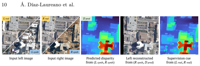
Summary. The paper proposes SeasonStereo, a framework for dense stereo matching of diachronic (multi-date) satellite image pairs. Starting from 871 highly consistent real synchronic WorldView-3 pairs curated by a multi-metric similarity consensus (Sec. 3.1), the authors use a text-conditioned generative model (Nano Banana Pro) to synthesize four seasonal variants per image, yielding 21,775 training pairs including 20 diachronic combinations per pair (Sec. 3.2). A MonSter++ backbone is then fine-tuned with a three-term loss (Eq. 4): an L1 disparity loss against frozen zero-shot MonSter++ predictions inherited from the real synchronic pair (Eq. 5), a photometric warping loss evaluated deliberately on the real synchronic pair rather than the synthetic diachronic input (Eq. 6), and an edge-aware smoothness regularizer (Eq. 8); water, tree, border, and occluded pixels are masked throughout (Fig. 5). On four test splits from DFC2019/IARPA, evaluated by altitude MAE of reconstructed DSMs against LiDAR-derived references, the full model ties its own LiDAR-supervised variant and the LiDAR-supervised prior art [41] at ~1.05 m average (Table 1), and the S1/S2/S3 ablation attributes the largest gain on the hardest split (Omaha Diachronic, 1.04→0.81) to synthetic diachronic data (Table 2). Qualitative results (Figs. 7–9) show sharper building contours than the LiDAR-trained baseline.
Significance. If the results hold, the paper removes the two most expensive ingredients of diachronic satellite stereo — aligned real multi-date training products and LiDAR-derived dense labels — replacing them with generative seasonal augmentation plus zero-shot foundation-model priors. Two features deserve explicit credit. First, despite the supervision loop being internally constructed (teacher disparities are inherited by construction from the real synchronic pairs, Eq. 5), the headline accuracy claim is validated externally: altitude MAE against LiDAR-derived DSMs on four held-out splits, so the parity-with-LiDAR-supervision claim is not tautological. Second, the authors commit to releasing a 21,775-pair real+synthetic dataset with rectification, validity masks, zero-shot and LiDAR-derived disparities — a concrete, reusable asset in a field where data scarcity is the acknowledged bottleneck. The S1→S3 ablation (Table 2) is a genuinely informative falsifiable check: synthetic diachronic augmentation helps most exactly where it should (Omaha Diachronic 1.04→0.81). The practical impact for large-scale 3D reconstruction from heterogeneous archives would be substantial.
major comments (4)
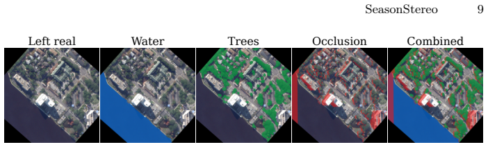
- [Sec. 3.3 / Eq. (5)] The load-bearing premise of the training scheme — stated in Sec. 3.3 ('Because the synthetic seasonal variants preserve geometry and alignment, these predictions can be transferred to supervise the corresponding synthetic diachronic pairs') — is asserted but never quantified. The only evidence is qualitative (Figs. 3–4), and the paper itself documents regimes where it fails: full 2048×2048 generation produces 'local hallucinations and distorted building contours' (Fig. 4), and water/tree regions are masked because generations are 'often inconsistent' (Sec. 3.2). This matters because both supervision terms are structurally blind to residual geometric error in the synthetic pair: in Eq. (5) the target D~ is inherited from the real synchronic pair, so a building edge displaced by ~1 px in the synthetic image receives a systematically wrong label with no corrective signal; and the phot oloss
- [Sec. 4 / Fig. 5] The valid-pixel mask V (Fig. 5) excludes water and tree pixels both during training (Eq. 5, 8) and evaluation (Sec. 4). The training exclusion is well motivated, but the evaluation consequence deserves explicit treatment: the classes where the geometry-preservation premise is admittedly violated are never tested, so Table 1's parity result is established only on the classes where the generator is not known to fail. The justification given (LiDAR–image temporal mismatch) is legitimate, but it applies to all methods equally and does not address the risk specific to this method. At minimum, please report the fraction of test pixels excluded by each mask component, and either (i) evaluate on water/tree regions of real diachronic pairs where the LiDAR reference is temporally reliable, or (ii) state clearly that performance on these land-cover classes is unknown. As written, a reader cannot
- [Sec. 4.2 / Table 1, Fig. 7] The second headline contribution — 'sharper geometric details' along building contours — is supported only qualitatively (Figs. 7–9, magenta markers). Table 1 itself shows no measurable gain from the terms that supposedly deliver it: (b) L_disp alone averages 1.06 with 0.79 on Omaha Diachronic, while the full model (d) averages 1.05 with 0.79 — within noise. Moreover, configuration (c) (adding L_photo) is worse than (b) on average (1.09 vs 1.06) and on Omaha Diachronic (0.84 vs 0.79), and this non-monotonicity is not discussed. If the photometric term improves boundary sharpness without improving global MAE, that is exactly the kind of claim that needs a boundary-sensitive metric: e.g., altitude/disparity error computed within a thin band around building edges (the building mask V_B is already available), or an edge-localization error between predicted discontinuities and image gradients
- [Table 1 / Sec. 4.2] The paper would benefit from a brief analysis of the teacher–student dynamics implicit in Table 1. The student in configuration (b) is trained purely to match a frozen MonSter++ teacher (Eq. 5), yet reaches avg. MAE 1.06 while the zero-shot teacher itself scores 1.93 (Table 1, row 2). This is plausible — fine-tuning on consistent synchronic pairs and photometric regularization can exceed the teacher's zero-shot accuracy — but it raises the question of where the student's error floor sits: teacher errors at building boundaries are inherited as labels by construction. A short discussion of this ceiling, ideally supported by comparing teacher vs. student error maps on the training AOIs against the LiDAR reference, would substantially strengthen the argument that zero-shot disparities are 'effective pseudo-ground truth' (Sec. 4.2) rather than merely adequate on average.
minor comments (7)
- [Sec. 2.1, Eq. (1)] Eq. (1) uses the symbol '⇐⇒' between I_L(x,y) and I_R(x−D(x,y),y), which reads as logical equivalence; standard correspondence notation (≈ or an explicit matching statement) would be clearer.
- [Eq. (3)] The schedule is typeset as 'γ = 0.9 15/(N−1)', which is ambiguous/garbled. Presumably γ = 0.9^(15/(N−1)) or similar; please fix the exponent notation and state N.
- [Sec. 4.1] λ_disp = 0.05 is set an order of magnitude below λ_photo = λ_smooth = 0.1 with no justification or sensitivity analysis. Given that L_disp is the only geometric term, a one-line rationale (or a small sensitivity sweep in supplementary) would help.
- [Fig. 3] The winter prompt in Fig. 3 is truncated with '(...)'. Since generation fidelity is sensitive to prompting, the full season-specific prompts should be included in supplementary material.
- [Sec. 3.2] Reproducibility: Nano Banana Pro is a proprietary, versioned API [24]. The released dataset mitigates this for the reported results, but please state the model version and access date, and note that regenerating the synthetic data may not be reproducible long-term.
- [Table 1] Test-set sizes (number of pairs per split in Table 1) are never reported, and the ±3.23 std for zero-shot MonSter++ on Omaha Diachronic suggests catastrophic failures on a subset of pairs; reporting outlier counts or median errors alongside MAE would make the comparison more informative.
- [Sec. 3.1] Several curation hyperparameters are arbitrary without stated sensitivity: d_max as the 95th percentile (Sec. 3.1), the top-1000 intersection threshold, and the 0.5/0.5 weighting in Eq. (2). A brief remark on robustness to these choices would suffice.
Circularity Check
No load-bearing circular derivation: pseudo-label transfer is by design, but the main accuracy claim is tested against external held-out LiDAR, not against the teacher.
specific steps
-
self citation load bearing
[Sec. 3.1–3.3; Table 1; comparison to Diachronic Stereo [41]]
"Building on this dataset, Masquil et al. [41] released a stereo matching benchmark comprising rectified synchronic and diachronic image pairs... We compare the zero-shot MonSter [15] and MonSter++ [14] models with Diachronic Stereo [41] and our SeasonStereo variants (a)-(d)"
The primary external baseline and the train/test splits are from Masquil et al. [41], which shares co-authors (Masquil, Marí, Facciolo) with the present paper. This is ordinary in-group benchmark reuse, not a uniqueness theorem that forces SeasonStereo’s result; evaluation still uses independent LiDAR MAE. Flagged only as minor self-citation, not load-bearing circularity.
full rationale
SeasonStereo’s chain is empirical method design, not a claimed first-principles derivation. Real synchronic pairs are curated; seasonal variants are synthesized under a geometry-preservation assumption; a frozen MonSter++ teacher supplies dense disparity targets (Eq. 5) that are copied onto aligned synthetic pairs; photometric and smoothness terms (Eqs. 6–8) are standard self-supervised regularizers evaluated on the real synchronic views. That L_disp equals the teacher on the training distribution is intentional distillation, not a tautological “prediction.” The central claim—parity with LiDAR-supervised Diachronic Stereo on altitude MAE (Table 1, avg. ~1.05 m) and sharper building edges—is measured against external LiDAR-derived DSMs on held-out Jacksonville / Buenos Aires / Omaha splits, with the same validity mask applied to all methods. Overlap with Masquil et al. [41] (shared co-authors, shared benchmark) is normal baseline/data reuse and does not force the reported numbers. The geometry-preservation premise is a weak external assumption (qualitative Figs. 3–4; water/trees masked), not a self-definitional loop. Score 1 only for mild same-family teacher→student self-distillation and in-group benchmark citation; neither reduces the main result by construction.
Axiom & Free-Parameter Ledger
free parameters (5)
- lambda_disp, lambda_photo, lambda_smooth =
0.05, 0.1, 0.1
- Scomb / S_DINOv3 top-1000 intersection threshold =
top-1000 intersection → 871 pairs
- photometric alpha and color d_max =
alpha=0.85; d_max=95th pct
- sequence loss gamma and N =
gamma schedule 0.9^{15/(N-1)}
- 1024×1024 center-crop generation extent =
1024×1024 center crops
axioms (5)
- standard math Rectified stereo correspondence is horizontal disparity as in Eq. (1).
- domain assumption Frozen MonSter++ zero-shot disparities on curated synchronic pairs are accurate enough dense pseudo-ground-truth for fine-tuning.
- ad hoc to paper Text-conditioned Nano Banana Pro seasonal edits preserve camera geometry, alignment, and man-made structure when prompted and cropped.
- domain assumption Water and tree regions are unreliable under generation and under temporal LiDAR mismatch, so excluding them from loss and MAE is valid.
- domain assumption Photometric loss on the real synchronic pair after warping with disparity predicted from (possibly synthetic) inputs improves boundary sharpness without requiring diachronic photometric consistency.
invented entities (2)
-
SeasonStereo multi-term supervision package (teacher disparity + synchronic photometric + edge-aware smoothness on synthetic diachronic inputs)
independent evidence
-
Released 21,775-pair real+synthetic seasonal satellite stereo dataset (JAX/OMA)
independent evidence
read the original abstract
Accurate 3D reconstruction from satellite imagery typically relies on near-simultaneous stereo pairs, limiting its applicability to diachronic settings where multi-date images exhibit varying seasonal and illumination conditions. Training dense stereo matching models robust to appearance changes is a long-standing challenge, as aligned multi-date imagery and ground-truth geometry are costly to obtain at scale. We propose SeasonStereo, a scalable framework that addresses disparity estimation from diachronic satellite images by training on synthetic image pairs with controlled seasonal appearance variation, while leveraging zero-shot geometric priors from foundation models. SeasonStereo matches the accuracy of state-of-the-art LiDAR-supervised models, while producing sharper geometric details without requiring aligned real multi-date training products or LiDAR-derived labels. As a result, SeasonStereo offers a practical path toward large-scale 3D reconstruction from heterogeneous satellite images with reduced supervision cost.
Figures




Reference graph
Works this paper leans on
-
[1]
The Photogrammetric Record37(180), 385–409 (2022)
Albanwan, H., Qin, R.: A comparative study on deep-learning methods for dense image matching of multi-angle and multi-date remote sensing stereo-images. The Photogrammetric Record37(180), 385–409 (2022)
2022
-
[2]
In: Proceedings of the IEEE/CVF Conference on Computer Vision and Pattern Recognition (CVPR) Workshops
Amadei, T., Meinhardt-Llopis, E., de Franchis, C., Anger, J., Ehret, T., Facciolo, G.: s2p-hd: GPU-accelerated binocular stereo pipeline for large-scale same-date stereo. In: Proceedings of the IEEE/CVF Conference on Computer Vision and Pattern Recognition (CVPR) Workshops. pp. 2364–2373 (2025)
2025
-
[3]
In: Proceedings of the IEEE/CVF Conference on Computer Vision and Pattern Recognition (CVPR)
Bartolomei, L., Tosi, F., Poggi, M., Mattoccia, S.: Stereo anywhere: Robust zero- shot deep stereo matching even where either stereo or mono fail. In: Proceedings of the IEEE/CVF Conference on Computer Vision and Pattern Recognition (CVPR). pp. 1013–1027 (June 2025)
2025
-
[4]
In: Proceedings of the IEEE/CVF Conference on Computer Vision and Pattern Recognition
Benidir, Y., Gonthier, N., Mallet, C.: The change you want to detect: Semantic change detection in earth observation with hybrid data generation. In: Proceedings of the IEEE/CVF Conference on Computer Vision and Pattern Recognition. pp. 2204–2214 (2025)
2025
-
[5]
Betker, J., Goh, G., Jing, L., Brooks, T., Wang, J., Li, L., Ouyang, L., Dinh, J., Contino, S., Tseng, T., et al.: Improving image generation with better captions. Tech. rep., OpenAI (2023)
2023
-
[6]
Earth and Space Science5(9), 537–548 (2018)
Beyer, R.A., Alexandrov, O., McMichael, S.: The Ames Stereo Pipeline: NASA’s open source software for deriving and processing terrain data. Earth and Space Science5(9), 537–548 (2018)
2018
-
[7]
Remote Sensing10(12), 1926 (2018)
Bittner, K., d’Angelo, P., Körner, M., Reinartz, P.: DSM-to-LoD2: Spaceborne stereo digital surface model refinement. Remote Sensing10(12), 1926 (2018)
1926
-
[8]
In: Proceedings of the IEEE Con- ference on Computer Vision and Pattern Recognition Workshops
Bittner, K., Korner, M.: Automatic large-scale 3D building shape refinement using conditional generative adversarial networks. In: Proceedings of the IEEE Con- ference on Computer Vision and Pattern Recognition Workshops. pp. 1887–1889 (2018)
2018
-
[9]
In: Proceedings of the IEEE/CVF Conference on Computer Vision and Pattern Recognition Workshops (2019)
Bittner, K., Reinartz, P., Korner, M.: Late or earlier information fusion from depth and spectral data? Large-scale digital surface model refinement by Hybrid-cGAN. In: Proceedings of the IEEE/CVF Conference on Computer Vision and Pattern Recognition Workshops (2019)
2019
-
[10]
In: 2019 IEEE Winter Conference on Appli- cations of Computer Vision (WACV)
Bosch, M., Foster, K., Christie, G., Wang, S., Hager, G.D., Brown, M.: Semantic stereo for incidental satellite images. In: 2019 IEEE Winter Conference on Appli- cations of Computer Vision (WACV). pp. 1524–1532 (2019)
2019
-
[11]
In: 2016 IEEE Applied Imagery Pattern Recognition Workshop (AIPR)
Bosch, M., Kurtz, Z., Hagstrom, S., Brown, M.: A multiple view stereo bench- mark for satellite imagery. In: 2016 IEEE Applied Imagery Pattern Recognition Workshop (AIPR). pp. 1–9 (2016)
2016
-
[12]
ISPRS Annals of the Photogrammetry, Remote Sensing and Spatial Information SciencesXI-2-2026, 217–224 (2026)
Bournez, P., Savant Aira, L., Ehret, T., Facciolo, G.: EOGS++: Earth observa- tion gaussian splatting with internal camera refinement and direct panchromatic rendering. ISPRS Annals of the Photogrammetry, Remote Sensing and Spatial Information SciencesXI-2-2026, 217–224 (2026)
2026
-
[13]
In: Laser Radar Technology and Applications XXIII
Brown, M., Goldberg, H., Foster, K., Leichtman, A., Wang, S., Hagstrom, S., Bosch, M., Almes, S.: Large-scale public lidar and satellite image data set for urban semantic labeling. In: Laser Radar Technology and Applications XXIII. vol. 10636, pp. 154–167 (2018)
2018
-
[14]
IEEE Transactions on Pattern Analysis and Machine Intelligence (2026) 16 Á
Cheng, J., Liao, W., Cai, Z., Liu, L., Xu, G., Wang, X., Wang, Y., Yuan, Z., Deng, Y., Zang, J., et al.: MonSter++: Unified stereo matching, multi-view stereo, and real-time stereo with monodepth priors. IEEE Transactions on Pattern Analysis and Machine Intelligence (2026) 16 Á. Díaz-Laureano et al
2026
-
[15]
In: Proceed- ings of the Computer Vision and Pattern Recognition Conference
Cheng, J., Liu, L., Xu, G., Wang, X., Zhang, Z., Deng, Y., Zang, J., Chen, Y., Cai, Z., Yang, X.: MonSter: Marry monodepth to stereo unleashes power. In: Proceed- ings of the Computer Vision and Pattern Recognition Conference. pp. 6273–6282 (2025)
2025
-
[16]
In: Proceedings of the IEEE/CVF International Conference on Computer Vision (ICCV)
Duggal, S., Wang, S., Ma, W.C., Hu, R., Urtasun, R.: DeepPruner: Learning efficient stereo matching via differentiable PatchMatch. In: Proceedings of the IEEE/CVF International Conference on Computer Vision (ICCV). pp. 4384–4393 (2019)
2019
-
[17]
ISPRS Annals of the Photogrammetry, Remote Sensing and Spatial In- formation Sciences2, 167–175 (2022)
Dumas, L., Defonte, V., Steux, Y., Sarrazin, E.: Improving pairwise DSM with 3SGM: A semantic segmentation for SGM using an automatically refined neural network. ISPRS Annals of the Photogrammetry, Remote Sensing and Spatial In- formation Sciences2, 167–175 (2022)
2022
-
[18]
In: Proceedings of the IEEE Conference on Com- puter Vision and Pattern Recognition Workshops
Facciolo, G., De Franchis, C., Meinhardt-Llopis, E.: Automatic 3D reconstruction from multi-date satellite images. In: Proceedings of the IEEE Conference on Com- puter Vision and Pattern Recognition Workshops. pp. 57–66 (2017)
2017
-
[19]
Facciolo, G., de Franchis, C., Meinhardt, E.: MGM: A significantly more global matchingforstereovision.In:ProceedingsoftheBritishMachineVisionConference (BMVC). pp. 1–12. No. 90 (2015)
2015
-
[20]
ISPRS Annals of the Photogrammetry, Remote Sensing and Spatial Information SciencesII-3, 49– 56 (2014)
de Franchis, C., Meinhardt-Llopis, E., Michel, J., Morel, J.M., Facciolo, G.: An automatic and modular stereo pipeline for pushbroom images. ISPRS Annals of the Photogrammetry, Remote Sensing and Spatial Information SciencesII-3, 49– 56 (2014)
2014
-
[21]
In: Proceedings of the IEEE conference on computer vision and pattern recognition
Godard, C., Mac Aodha, O., Brostow, G.J.: Unsupervised monocular depth es- timation with left-right consistency. In: Proceedings of the IEEE conference on computer vision and pattern recognition. pp. 270–279 (2017)
2017
-
[22]
In: Proceedings of the IEEE/CVF in- ternational conference on computer vision
Godard, C., Mac Aodha, O., Firman, M., Brostow, G.J.: Digging into self- supervised monocular depth estimation. In: Proceedings of the IEEE/CVF in- ternational conference on computer vision. pp. 3828–3838 (2019)
2019
-
[23]
In: Proceedings of the IEEE/CVF Winter Conference on Applications of Computer Vision
Gómez, A., Randall, G., Facciolo, G., von Gioi, R.G.: Improving the pair selection and the model fusion steps of satellite multi-view stereo pipelines. In: Proceedings of the IEEE/CVF Winter Conference on Applications of Computer Vision. pp. 6344–6353 (2023)
2023
-
[24]
Google AI: Gemini 3 Pro Image.https://ai.google.dev/gemini- api/docs/ models/gemini-3-pro-image(2026), accessed: 2026-06-24
2026
-
[25]
IEEE Transactions on Pattern Analysis and Machine Intelligence30(2), 328– 341 (2008)
Hirschmüller, H.: Stereo processing by semiglobal matching and mutual informa- tion. IEEE Transactions on Pattern Analysis and Machine Intelligence30(2), 328– 341 (2008)
2008
-
[26]
In: Proceedings of the IEEE/CVF International Conference on Computer Vision
Jakubik, J., Yang, F., Blumenstiel, B., Scheurer, E., Sedona, R., Maurogiovanni, S., Bosmans, J., Dionelis, N., Marsocci, V., Kopp, N., et al.: TerraMind: Large-scale generative multimodality for earth observation. In: Proceedings of the IEEE/CVF International Conference on Computer Vision. pp. 7383–7394 (2025)
2025
-
[27]
In: Proceedings of the IEEE International Conference on Computer Vision (ICCV)
Kendall, A., Martirosyan, H., Dasgupta, S., Henry, P., Kennedy, R., Bachrach, A., Bry, A.: End-to-end learning of geometry and context for deep stereo regression. In: Proceedings of the IEEE International Conference on Computer Vision (ICCV). pp. 66–75 (2017)
2017
-
[28]
In: International Conference on Learning Representations
Khanna, S., Liu, P., Zhou, L., Meng, C., Rombach, R., Burke, M., Lobell, D., Ermon, S.: DiffusionSat: A generative foundation model for satellite imagery. In: International Conference on Learning Representations. vol. 2024, pp. 5586–5604 (2024) SeasonStereo 17
2024
-
[29]
In: European Con- ference on Computer Vision (ECCV)
Khose, S., Pal, A., Agarwal, A., Deepanshi, Hoffman, J., Chattopadhyay, P.: SkyScenes: A synthetic dataset for aerial scene understanding. In: European Con- ference on Computer Vision (ECCV). pp. 19–35 (2024)
2024
-
[30]
In: Proceedings of the IEEE/CVF Conference on Computer Vision and Pattern Recognition (CVPR) Workshops (2026)
Kim, H.G., Park, J., Park, J., Kwon, D.: SatUnreal: A high-precision synthetic dataset for satellite stereo matching via Unreal Engine. In: Proceedings of the IEEE/CVF Conference on Computer Vision and Pattern Recognition (CVPR) Workshops (2026)
2026
-
[31]
IEEE Transactions on Geoscience and Remote Sensing55(3), 1477–1488 (2016)
Kuschk, G., d’Angelo, P., Gaudrie, D., Reinartz, P., Cremers, D.: Spatially reg- ularized fusion of multiresolution digital surface models. IEEE Transactions on Geoscience and Remote Sensing55(3), 1477–1488 (2016)
2016
-
[32]
IEEE Transactions on Pattern Analysis and Machine Intelligence44(4), 1738–1764 (2020)
Laga, H., Jospin, L.V., Boussaid, F., Bennamoun, M.: A survey on deep learn- ing techniques for stereo-based depth estimation. IEEE Transactions on Pattern Analysis and Machine Intelligence44(4), 1738–1764 (2020)
2020
-
[33]
IEEE Geoscience and Remote Sensing Magazine 7(1), 103–105 (2019)
Le Saux, B., Yokoya, N., Hansch, R., Brown, M., Hager, G.: 2019 Data Fusion Contest [Technical Committees]. IEEE Geoscience and Remote Sensing Magazine 7(1), 103–105 (2019)
2019
-
[34]
IEEE Transactions on Geoscience and Remote Sensing61, 1–14 (2023)
Li, S., He, S., Jiang, S., Jiang, W., Zhang, L.: WHU-Stereo: A challenging bench- mark for stereo matching of high-resolution satellite images. IEEE Transactions on Geoscience and Remote Sensing61, 1–14 (2023)
2023
-
[35]
In: 2021 International conference on 3D vision (3DV)
Lipson, L., Teed, Z., Deng, J.: RAFT-Stereo: Multilevel recurrent field transforms for stereo matching. In: 2021 International conference on 3D vision (3DV). pp. 218–227 (2021)
2021
-
[36]
In: 2021 IEEE International Geoscience and Remote Sensing Symposium IGARSS
Marí, R., De Franchis, C., Meinhardt-Llopis, E., Facciolo, G.: Automatic stockpile volume monitoring using multi-view stereo from SkySat imagery. In: 2021 IEEE International Geoscience and Remote Sensing Symposium IGARSS. pp. 4384–4387 (2021)
2021
-
[37]
Image Processing On Line12, 501–526 (2022)
Marí, R., Ehret, T., Facciolo, G.: Disparity estimation networks for aerial and high-resolution satellite images: A review. Image Processing On Line12, 501–526 (2022)
2022
-
[38]
In: 2022 IEEE/CVF Conference on Computer Vision and Pattern Recognition Work- shops (CVPRW)
Marí, R., Facciolo, G., Ehret, T.: Sat-NeRF: Learning multi-view satellite pho- togrammetry with transient objects and shadow modeling using RPC cameras. In: 2022 IEEE/CVF Conference on Computer Vision and Pattern Recognition Work- shops (CVPRW). pp. 1310–1320 (2022)
2022
-
[39]
In: 2023 IEEE/CVF Conference on Computer Vision and Pattern Recognition Workshops (CVPRW)
Marí, R., Facciolo, G., Ehret, T.: Multi-date earth observation NeRF: The detail is in the shadows. In: 2023 IEEE/CVF Conference on Computer Vision and Pattern Recognition Workshops (CVPRW). pp. 2035–2045 (2023)
2023
-
[40]
Image Processing On Line15, 20–31 (2025)
Marí, R., Redondo, R.: Latent Diffusion Approaches for Conditional Generation of Aerial Imagery: A Study. Image Processing On Line15, 20–31 (2025)
2025
-
[41]
ISPRS Annals of the Photogram- metry, Remote Sensing and Spatial Information SciencesXI-2-2026, 483–492 (2026)
Masquil, E., Aira, L.S., Marí, R., Ehret, T., Musé, P., Facciolo, G.: Diachronic stereo matching for multi-date satellite imagery. ISPRS Annals of the Photogram- metry, Remote Sensing and Spatial Information SciencesXI-2-2026, 483–492 (2026)
2026
-
[42]
arXiv preprint arXiv:2603.21882 (2026)
Masquil, E., Ehret, T., Musé, P., Facciolo, G.: Deep S2P: Integrating learning based stereo matching into the satellite stereo pipeline. arXiv preprint arXiv:2603.21882 (2026)
arXiv 2026
-
[43]
In: ISPRS Annals of the Pho- togrammetry, Remote Sensing and Spatial Information Sciences
Michel, J., Sarrazin, E., Youssefi, D., Cournet, M., Buffe, F., Delvit, J.M., Emilien, A., Bosman, J., Melet, O., L’Helguen, C.: A new satellite imagery stereo pipeline designed for scalability, robustness and performance. In: ISPRS Annals of the Pho- togrammetry, Remote Sensing and Spatial Information Sciences. vol. V-2-2020, pp. 171–178 (2020) 18 Á. Día...
2020
-
[44]
MIT License
odil111: SegFormer Fine-Tuned on OpenEarthMap.https://huggingface.co/ odil111/segformer-fine-tuned-on-openearthmap(2024), Hugging Face model repository. MIT License. Accessed: 2026-06-24
2024
-
[45]
arXiv preprint arXiv:1907.04404 (2019)
Patil, S., Comandur, B., Prakash, T., Kak, A.C.: A new stereo benchmarking dataset for satellite images. arXiv preprint arXiv:1907.04404 (2019)
Pith/arXiv arXiv 1907
-
[46]
International Archives of the Photogrammetry, Remote Sensing and Spatial Information SciencesXL VIII-M-1-2023, 433–440 (2023)
Patil, S., Guo, Q.: Stellar: A large satellite stereo dataset for digital surface model generation. International Archives of the Photogrammetry, Remote Sensing and Spatial Information SciencesXL VIII-M-1-2023, 433–440 (2023)
2023
-
[47]
In: ASPRS Annual Conference (2017)
Qin, R.: Automated 3D recovery from very high resolution multi-view images. In: ASPRS Annual Conference (2017)
2017
-
[48]
ISPRS Journal of Photogrammetry and Remote Sensing154, 139–150 (2019)
Qin, R.: A critical analysis of satellite stereo pairs for digital surface model genera- tion and a matching quality prediction model. ISPRS Journal of Photogrammetry and Remote Sensing154, 139–150 (2019)
2019
-
[49]
Remote Sensing14(6), 1309 (2022)
Qin, R., Ling, X., Farella, E.M., Remondino, F.: Uncertainty-guided depth fusion from multi-view satellite images to improve the accuracy in large-scale DSM gen- eration. Remote Sensing14(6), 1309 (2022)
2022
-
[50]
Open geospatial data, software and standards2(1), 14 (2017)
Rupnik, E., Daakir, M., Pierrot Deseilligny, M.: MicMac–a free, open-source solu- tion for photogrammetry. Open geospatial data, software and standards2(1), 14 (2017)
2017
-
[51]
In: Proceedings of the IEEE/CVF Conference on Computer Vision and Pattern Recognition (CVPR)
Savant Aira, L., Facciolo, G., Ehret, T.: Gaussian splatting for efficient satellite im- age photogrammetry. In: Proceedings of the IEEE/CVF Conference on Computer Vision and Pattern Recognition (CVPR). pp. 5959–5969 (2025)
2025
-
[52]
International Journal of Computer Vision47(1-3), 7– 42 (2002)
Scharstein, D., Szeliski, R.: A taxonomy and evaluation of dense two-frame stereo correspondence algorithms. International Journal of Computer Vision47(1-3), 7– 42 (2002)
2002
-
[53]
arXiv preprint arXiv:2508.10104 (2025)
Siméoni, O., Vo, H.V., Seitzer, M., Baldassarre, F., Oquab, M., Jose, C., Khali- dov, V., Szafraniec, M., Yi, S., Ramamonjisoa, M., et al.: DINOv3. arXiv preprint arXiv:2508.10104 (2025)
Pith/arXiv arXiv 2025
-
[54]
ISPRS Journal of Photogrammetry and Remote Sensing183, 560–580 (2022)
Stucker, C., Schindler, K.: ResDepth: A deep residual prior for 3D reconstruc- tion from high-resolution satellite images. ISPRS Journal of Photogrammetry and Remote Sensing183, 560–580 (2022)
2022
-
[55]
International Journal of Computer Vision133(7), 4245–4276 (2025)
Tosi, F., Bartolomei, L., Poggi, M.: A survey on deep stereo matching in the twen- ties. International Journal of Computer Vision133(7), 4245–4276 (2025)
2025
-
[56]
arXiv preprint arXiv:2410.04738 (2024)
Wang, Z., Li, D., Wu, Y., He, T., Bian, J., Jiang, R.: Diffusion models in 3D vision: A survey. arXiv preprint arXiv:2410.04738 (2024)
Pith/arXiv arXiv 2024
-
[57]
IEEE Transactions on Image Process- ing13(4), 600–612 (2004)
Wang, Z., Bovik, A.C., Sheikh, H.R., Simoncelli, E.P.: Image quality assessment: From error visibility to structural similarity. IEEE Transactions on Image Process- ing13(4), 600–612 (2004)
2004
-
[58]
In: Proceedings of the IEEE/CVF Conference on Computer Vision and Pattern Recognition
Wen, B., Trepte, M., Aribido, J., Kautz, J., Gallo, O., Birchfield, S.: Foundation- Stereo: Zero-shot stereo matching. In: Proceedings of the IEEE/CVF Conference on Computer Vision and Pattern Recognition. pp. 5249–5260 (2025)
2025
-
[59]
Wu, T., Vallet, B., Pierrot-Deseilligny, M., Rupnik, E.: A new stereo dense match- ingbenchmarkdatasetfordeeplearning.TheInternationalArchivesofPhotogram- metry, Remote Sensing and Spatial Information Sciences43, 405–412 (2021)
2021
-
[60]
In: Proceedings of the IEEE/CVF Winter Conference on Applications of Computer Vision
Xia, J., Yokoya, N., Adriano, B., Broni-Bediako, C.: OpenEarthMap: A bench- mark dataset for global high-resolution land cover mapping. In: Proceedings of the IEEE/CVF Winter Conference on Applications of Computer Vision. pp. 6254–6264 (2023)
2023
-
[61]
In: Ad- vances in Neural Information Processing Systems
Xie, E., Wang, W., Yu, Z., Anandkumar, A., Alvarez, J.M., Luo, P.: SegFormer: Simple and efficient design for semantic segmentation with transformers. In: Ad- vances in Neural Information Processing Systems. vol. 34, pp. 12077–12090 (2021) SeasonStereo 19
2021
-
[62]
In: Proceedings of the IEEE/CVF Conference on Computer Vision and Pattern Recognition (CVPR)
Yang, G., Manela, J., Happold, M., Ramanan, D.: Hierarchical deep stereo match- ing on high-resolution images. In: Proceedings of the IEEE/CVF Conference on Computer Vision and Pattern Recognition (CVPR). pp. 5515–5524 (2019)
2019
-
[63]
Advances in Neural Information Processing Systems37, 21875–21911 (2024)
Yang,L.,Kang,B.,Huang,Z.,Zhao,Z.,Xu,X.,Feng,J.,Zhao,H.:DepthAnything V2. Advances in Neural Information Processing Systems37, 21875–21911 (2024)
2024
-
[64]
In: European Conference on Computer Vision (ECCV)
Zabih, R., Woodfill, J.: Non-parametric local transforms for computing visual cor- respondence. In: European Conference on Computer Vision (ECCV). pp. 151–158 (1994)
1994
-
[65]
In: Proceedings of the IEEE/CVF Conference on Computer Vision and Pattern Recognition (CVPR)
Zhang, F., Prisacariu, V., Yang, R., Torr, P.H.: GA-Net: Guided aggregation net for end-to-end stereo matching. In: Proceedings of the IEEE/CVF Conference on Computer Vision and Pattern Recognition (CVPR). pp. 185–194 (2019)
2019
-
[66]
ISPRS Annals of the Photogrammetry, Remote Sensing and Spatial Information Sciences1, 895–902 (2023)
Zhang, L., Rupnik, E.: SparseSat-NeRF dense depth supervised neural radiance fields for sparse satellite images. ISPRS Annals of the Photogrammetry, Remote Sensing and Spatial Information Sciences1, 895–902 (2023)
2023
-
[67]
In: Proceedings of the IEEE Conference on Computer Vision and Pattern Recognition (CVPR)
Zhao, H., Shi, J., Qi, X., Wang, X., Jia, J.: Pyramid scene parsing network. In: Proceedings of the IEEE Conference on Computer Vision and Pattern Recognition (CVPR). pp. 6230–6239 (2017)
2017
discussion (0)
Sign in with ORCID, Apple, or X to comment. Anyone can read and Pith papers without signing in.