REVIEW 3 major objections 5 minor 31 references
Coverage Path Planning using Path Primitive Sampling and Primitive Coverage Graph for Visual Inspection
T0 review · 3 major / 5 minor · reviewed 2026-08-14 · deepseek-v4-flash
Pith's one-line read Directly sampling flight segments, not viewpoints, shortens UAV inspection paths by 18–29%.
desk verdict A genuinely new primitive-based coverage formulation with real practical promise, but the 18-29% savings claim is undercut by missing achieved-coverage numbers and no guarantee that the greedy search can reach the 99% target. read the letter →
The pith
A machine-rendered reading of the paper's core claim, the machinery that carries it, and where it could break.
The reading
What carries the argument
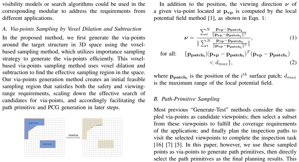
The central object is the Primitive Coverage Graph (PCG), a graph whose nodes are sampled via-points and whose edges are path primitives. Each edge stores the flight distance and an m-dimensional binary visibility vector indicating which surface patches of the target are visible from that segment. The load-bearing mechanism is the Greedy Neighborhood Search: starting from an initial edge, it repeatedly extends the current path by the neighboring primitive with the highest incremental coverage per unit flight distance until the desired coverage ratio is reached. Supporting mechanisms are voxel dilation and subtraction to define the sampling region and a sampling-based visibility estimator that combines the visibility of several viewpoints along each primitive into one edge attribute.
What would settle it
On either of the two test structures, run the proposed planning pipeline with the reported parameters, fly the resulting path in a camera-equipped simulator, and reconstruct the target as a voxel model; if the achieved surface coverage falls below 99% for a feasible sampling budget, or if the flown path length does not beat the 507.7 m and 587.5 m VPP-TSP baselines, the central claim fails.
Extended reading notes
Core claim
The central claim is that the coverage path planning problem for UAV visual inspection is better solved by making the path itself the sampling unit. The authors argue that sampling via-points in a shell around the target, obtained by voxel dilation and subtraction, connecting nearby via-points into collision-free path primitives, and encoding these primitives as edges in a Primitive Coverage Graph allows a greedy search to assemble a connected, unbranched inspection path that directly satisfies coverage constraints while minimizing flight distance. They report that on two target structures this yields 425.6 m and 466.2 m paths versus 507.7 m and 587.5 m for the viewpoint-plus-TSP baseline and 531.0 m and 687.1 m for the greedy viewpoint baseline, corresponding to 18.4% and 29.2% reductions in required inspection time at constant speed. The paper claims this advantage follows because the path primitive is the natural unit for a camera that records video continuously, and because visibility is precomputed per path segment rather than per viewpoint.
Load-bearing premise
The load-bearing premise is that the randomly sampled via-points and path primitives happen to form a connected, branchless path that can reach the desired 99% coverage; the paper gives no guarantee that this happens for a chosen sampling density.
Editorial extensions
If this is right
- Inspection paths can be generated as continuous collision-free flight segments rather than as an abstract set of waypoints, so the planned trajectory matches video-stream capture directly.
- The 18.4% and 29.2% flight-time reductions imply that, for constant-speed UAVs, comparable coverage can be obtained with proportionally shorter endurance requirements.
- Because visibility is precomputed per path primitive, the graph search itself only combines coverage bitsets and distances, keeping the search cheap after the offline graph construction.
- The modular design means other local planners, sampling strategies, visibility models, or search algorithms can be plugged in without changing the PCG encoding.
- The field-test reconstruction from 87 sampled video frames suggests that the planned paths provide enough visual overlap and viewpoint continuity for structure-from-motion reconstruction.
Reading between the lines
- Treating edges rather than nodes as the coverage unit suggests a general principle for streaming sensors: when the camera records continuously, the segment, not the viewpoint, is the atomic measurement, and the same reframing may apply to manipulator painting or polishing tasks.
- The greedy edge-addition rule resembles submodular coverage maximization, so an exchange or local-search step after Greedy Neighborhood Search might recover some of the optimality gap; the paper does not claim optimality.
- A testable extension is to re-run the comparison with visibility computed only from discrete viewpoints rather than from path primitives; if the gap disappears, the advantage may come from the visibility model rather than from path-primitive search itself.
- Because the framework is offline and model-based, adapting it to changing environments would require incremental PCG updates, which the paper leaves open.
Signed reviews
Editorial analysis
A structured set of objections, weighed in public.
Referee Report
Summary. The paper proposes an offline coverage path planning (CPP) method for UAV visual inspection that operates directly on path primitives rather than on discrete viewpoints. The method voxelizes the target structure, generates via-points in a dilated-and-subtracted sampling region, connects via-point pairs into path primitives, precomputes visibility per primitive, encodes the result in a Primitive Coverage Graph (PCG), and searches the graph with a Greedy Neighborhood Search (GNS) to find a connected, branchless path meeting a prescribed coverage ratio. Simulation with Drake and Octomap and one real-world DJI field test are presented, and the reported flight-path lengths are 18.4% and 29.2% shorter on average than two viewpoint-based baselines.
Significance. The path-primitive formulation is a genuine and sensible departure from the prevailing viewpoint-selection-plus-TSP pipeline, and the modular design, the edge-encoded visibility representation, and the inclusion of a real drone field test are clear strengths. The reported savings are suggestive, but the central evidence is incomplete: the achieved coverage ratio is never quantified, no variance is reported for the path lengths, and the greedy search has no termination or feasibility guarantee. Because the central claim is that the method satisfies coverage requirements while reducing flight time, these gaps are load-bearing. If the authors supply quantitative coverage verification, statistical support, and a convergence or repair mechanism for the search, the contribution would be solid and of interest to the robotics and inspection-planning communities.
major comments (3)
- [Section IV-B, Table II] The central quantitative claim—18.4% and 29.2% reductions in flight time—is not tied to a demonstrated coverage level. Table II reports only mean path lengths, and Section IV-B states that coverage is validated only through the reconstructed voxel visualizations in Fig. 10. For an apples-to-apples comparison, the paper must report the achieved coverage ratio (e.g., fraction of surface patches visible or fraction of target voxels reconstructed) for the proposed method and for both baselines in the Drake-Octomap simulation, ideally per trial and with standard deviations. Without this, the savings could reflect incomplete coverage rather than improved efficiency.
- [Section III-E, Algorithm 3] The Greedy Neighborhood Search has no termination or feasibility guarantee. The while loop (δ≤δd) assumes that the randomly sampled PCG contains a connected, branchless path whose union reaches δd, but Algorithms 1–2 provide no completeness or connectivity guarantee for a given sampling density. In particular, FindTraj (Eq. 4) may reach a via-point whose neighbor set contains no edge with positive incremental coverage, or no unvisited neighbor, before δd is reached; the algorithm then cannot proceed. The paper should either prove termination/completeness under explicit sampling assumptions, add an expansion/repair mechanism, or report an empirical study over sampling densities showing how often and at what cost δd is reached.
- [Section IV-B, Table II] The results are averages over 10 trials reported without variance or statistical testing, so the 18.4% and 29.2% improvements cannot be distinguished from run-to-run noise. Report standard deviations (or confidence intervals) and, ideally, a paired test across the same target models.
minor comments (5)
- [Algorithm 3, line 2] Line 2 computes δ←FindCoverage(G,e) using e before it is initialized in line 3; reorder the initialization or remove this line.
- [Equations (1)–(2) and Algorithm 1] The symbol dmax is used both for the maximum range of the local potential field in Eq. (2) and for the maximum distance for path-primitive sampling in Algorithm 1; use distinct symbols to avoid ambiguity.
- [Section IV-B, Fig. 10] The reconstructed voxel models are shown only visually; a quantitative comparison with the ground-truth voxel model (e.g., precision/recall or IoU) would strengthen the coverage validation.
- [Section IV-C] For the field test, the paper mentions that 87 pictures were sampled from the video and used for SFM reconstruction, but no coverage metric is reported for the real-world result; a quantitative completeness measure would help.
- [Throughout] There are typographical and formatting issues, including 'UA Vs' in the Related Work, 'papaer' in the Field Test section, and inconsistent spacing around references; these should be corrected.
Circularity Check
No significant circularity: the planning derivation is self-contained and the flight-time reductions are experimental outputs, not fitted or definitionally forced quantities.
full rationale
The paper's planning chain is self-contained: Algorithm 1 samples via-points and path primitives, Algorithm 2 constructs the Primitive Coverage Graph with edge lengths and binary visibility vectors, and Algorithm 3 greedily searches that graph. The reported path lengths in Table II are outputs of this search, not parameters fitted to reproduce the claimed 18.4% and 29.2% reductions. The coverage requirement enters as a user-chosen input (delta_d = 99.0% in Table I), and Algorithm 3's loop condition enforces it within the planner's own visibility model; this is a planning constraint, not a circular prediction. The visibility model is stated as an assumption drawn from prior work and similar external work, and the Drake/Octomap simulation and SFM field reconstruction are presented as independent validation attempts. The paper does cite the authors' own prior work for the viewing-direction computation, visibility model, and the VPP-TSP baseline, but these self-citations are component choices and benchmark comparisons rather than load-bearing derivations of the main claim. The possible absence of a termination guarantee for Algorithm 3 and the lack of reported achieved coverage ratios are correctness and evidence concerns, not circularity. No equation or quantity in the paper reduces by construction to an input or to a self-citation.
Assumptions & free parameters
free parameters (7)
- Maximum distance for path primitive sampling (d_max) =
not reported
- Max viewing range (d_vis) =
50 m simulation, 10 m field test
- Safety distance (d_safe) =
2 m simulation, 0.5 m field test
- Desired coverage ratio (delta_d) =
99.0%
- Number of via-points (n_vp) =
not reported; 1,765 and 1,410 primitives generated
- Visibility sampling density per path primitive =
not reported
- Voxel resolution =
not reported
assumptions (5)
- domain assumption The target 3D model is available and static during planning and execution.
- domain assumption Visibility from a path can be approximated by binary visibility from finite viewpoints sampled along that path.
- domain assumption Straight-line segments with collision checking are executable by the UAV.
- domain assumption Surface coverage can be measured as the fraction of triangular patches seen by at least one selected path primitive.
- ad hoc to paper The greedy incremental coverage-per-distance heuristic returns an acceptable inspection path.
Cite this review
Pith. "Pith review of Coverage Path Planning using Path Primitive Sampling and Primitive Coverage Graph for Visual Inspection." pith.science (2026). https://pith.science/paper/ZCJL7HTT
@misc{pith2026190802901,
  author       = {Pith},
  title        = {Pith review of: Coverage Path Planning using Path Primitive Sampling and Primitive Coverage Graph for Visual Inspection},
  year         = {2026},
  howpublished = {\url{https://pith.science/paper/ZCJL7HTT}},
  note         = {Machine review of arXiv:1908.02901}
}
read the original abstract
Planning the path to gather the surface information of the target objects is crucial to improve the efficiency of and reduce the overall cost, for visual inspection applications with Unmanned Aerial Vehicles (UAVs). Coverage Path Planning (CPP) problem is often formulated for these inspection applications because of the coverage requirement. Traditionally, researchers usually plan and optimize the viewpoints to capture the surface information first, and then optimize the path to visit the selected viewpoints. In this paper, we propose a novel planning method to directly sample and plan the inspection path for a camera-equipped UAV to acquire visual and geometric information of the target structures as a video stream setting in complex 3D environment. The proposed planning method first generates via-points and path primitives around the target object by using sampling methods based on voxel dilation and subtraction. A novel Primitive Coverage Graph (PCG) is then proposed to encode the topological information, flying distances, and visibility information, with the sampled via-points and path primitives. Finally graph search is performed to find the resultant path in the PCG to complete the inspection task with the coverage requirements. The effectiveness of the proposed method is demonstrated through simulation and field tests in this paper.
Figures


Figures from the paper (8 more)


Reference graph
Works this paper leans on
-
[1]
Sampling-based view planning for 3d visual coverage task with unmanned aerial vehicle,
W. Jing, J. Polden, W. Lin, and K. Shimada, “Sampling-based view planning for 3d visual coverage task with unmanned aerial vehicle,” in IEEE/RSJ International Conference on Intelligent Robots and Systems. IEEE, 2016, pp. 1808–1815
work page 2016
-
[2]
A. Bircher, K. Alexis, M. Burri, P. Oettershagen, S. Omari, T. Mantel, and R. Siegwart, “Structural inspection path planning via iterative viewpoint resampling with application to aerial robotics,” in IEEE International Conference on Robotics and Automation . IEEE, 2015, pp. 6423–6430
work page 2015
-
[3]
Heterogeneous vehicles routing for water canal damage assessment,
D. Deng, T. Pang, P. Palli, F. Shu, and K. Shimada, “Heterogeneous vehicles routing for water canal damage assessment,” in IEEE/RSJ International Conference on Intelligent Robots and Systems . IEEE, 2018, pp. 2375–2382
work page 2018
-
[4]
A survey on coverage path planning for robotics,
E. Galceran and M. Carreras, “A survey on coverage path planning for robotics,” Robotics and Autonomous Systems , vol. 61, no. 12, pp. 1258–1276, 2013
work page 2013
-
[5]
View planning for 3d shape reconstruction of buildings with unmanned aerial vehicles,
W. Jing, J. Polden, P. Y . Tao, W. Lin, and K. Shimada, “View planning for 3d shape reconstruction of buildings with unmanned aerial vehicles,” in International Conference on Control, Automation, Robotics and Vision . IEEE, 2016, pp. 1–6
work page 2016
-
[6]
Three-dimensional coverage planning for an underwater inspection robot,
B. Englot and F. S. Hover, “Three-dimensional coverage planning for an underwater inspection robot,”The International Journal of Robotics Research, vol. 32, no. 9-10, pp. 1048–1073, 2013
work page 2013
-
[7]
W. R. Scott, “Model-based view planning,” Machine Vision and Applications, vol. 20, no. 1, pp. 47–69, 2009
work page 2009
-
[8]
View planning for automated 3d object reconstruction inspection,
W. Scott, G. Roth, and J.-F. Rivest, “View planning for automated 3d object reconstruction inspection,” ACM Computing Surveys , vol. 35, no. 1, 2003
work page 2003
Show all 31 references
-
[9]
Active vision in robotic systems: A survey of recent developments,
S. Chen, Y . Li, and N. M. Kwok, “Active vision in robotic systems: A survey of recent developments,” The International Journal of Robotics Research, vol. 30, no. 11, pp. 1343–1377, 2011
2011
-
[10]
Robotic task sequenc- ing problem: A survey,
S. Alatartsev, S. Stellmacher, and F. Ortmeier, “Robotic task sequenc- ing problem: A survey,” Journal of Intelligent & Robotic Systems , vol. 80, no. 2, pp. 279–298, 2015
2015
-
[11]
Coverage planning for robotic vision applications in complex 3d environment,
W. Jing, “Coverage planning for robotic vision applications in complex 3d environment,” Ph.D. dissertation, Carnegie Mellon University, 2017
2017
-
[12]
Planning for complete sensor coverage in inspection,
G. H. Tarbox and S. N. Gottschlich, “Planning for complete sensor coverage in inspection,” Computer Vision and Image Understanding , vol. 61, no. 1, pp. 84–111, 1995
1995
-
[13]
View plan- ning for 3d object reconstruction with a mobile manipulator robot,
J. I. Vasquez-Gomez, L. E. Sucar, and R. Murrieta-Cid, “View plan- ning for 3d object reconstruction with a mobile manipulator robot,” in IEEE/RSJ International Conference on Intelligent Robots and Systems. IEEE, 2014, pp. 4227–4233
2014
-
[14]
Online inspection path planning for autonomous 3d modeling using a micro-aerial vehicle,
S. Song and S. Jo, “Online inspection path planning for autonomous 3d modeling using a micro-aerial vehicle,” in IEEE International Conference on Robotics and Automation . IEEE, 2017, pp. 6217– 6224
2017
-
[15]
A reinforcement learning approach to the view planning problem
M. D. Kaba, M. G. Uzunbas, and S.-N. Lim, “A reinforcement learning approach to the view planning problem.” in Conference on Computer Vision and Pattern Recognition (CVPR) , 2017, pp. 5094–5102
2017
-
[16]
Automatic sensor placement for model-based robot vision,
S. Chen and Y . Li, “Automatic sensor placement for model-based robot vision,” IEEE Transactions on Systems, Man, and Cybernetics, Part B: Cybernetics, vol. 34, no. 1, pp. 393–408, 2004
2004
-
[17]
Sampling-based coverage motion planning for industrial inspection application with redundant robotic system,
W. Jing, J. Polden, C. F. Goh, M. Rajaraman, W. Lin, and K. Shimada, “Sampling-based coverage motion planning for industrial inspection application with redundant robotic system,” in IEEE/RSJ International Conference on Intelligent Robots and Systems. IEEE, 2017, pp. 5211– 5218
2017
-
[18]
View planning problem with combined view and traveling cost,
P. Wang, R. Krishnamurti, and K. Gupta, “View planning problem with combined view and traveling cost,” in IEEE International Conference on Robotics and Automation . IEEE, 2007, pp. 711–716
2007
-
[19]
A survey on inspecting structures using robotic systems,
R. Almadhoun, T. Taha, L. Seneviratne, J. Dias, and G. Cai, “A survey on inspecting structures using robotic systems,” International Journal of Advanced Robotic Systems , vol. 13, no. 6, p. 1729881416663664, 2016
2016
-
[20]
Coverage for robotics–a survey of recent results,
H. Choset, “Coverage for robotics–a survey of recent results,” Annals of mathematics and artificial intelligence , vol. 31, no. 1-4, pp. 113– 126, 2001
2001
-
[21]
A survey of sensor planning in computer vision,
K. A. Tarabanis, P. K. Allen, and R. Y . Tsai, “A survey of sensor planning in computer vision,” IEEE Transactions on Robotics and Automation, vol. 11, no. 1, pp. 86–104, 1995
1995
-
[22]
Submodular trajectory optimization for aerial 3d scanning
M. Roberts, S. Shah, D. Dey, A. Truong, S. N. Sinha, A. Kapoor, P. Hanrahan, and N. Joshi, “Submodular trajectory optimization for aerial 3d scanning.” in International Conference on Computer Vision (ICCV), 2017, pp. 5334–5343
2017
-
[23]
Asymp- totically optimal inspection planning using systems with differential constraints,
G. Papadopoulos, H. Kurniawati, and N. M. Patrikalakis, “Asymp- totically optimal inspection planning using systems with differential constraints,” in IEEE International Conference on Robotics and Au- tomation. IEEE, 2013, pp. 4126–4133
2013
-
[24]
S. M. LaValle, Planning algorithms . Cambridge university press, 2006
2006
-
[25]
Prob- abilistic roadmaps for path planning in high-dimensional configuration spaces,
L. E. Kavraki, P. ˇSvestka, J.-C. Latombe, and M. H. Overmars, “Prob- abilistic roadmaps for path planning in high-dimensional configuration spaces,” IEEE TRANSACTIONS ON ROBOTICS AND AUTOMATION, vol. 12, no. 4, 1996
1996
-
[26]
Bubble mesh: automated triangular meshing of non-manifold geometry by sphere packing,
K. Shimada and D. C. Gossard, “Bubble mesh: automated triangular meshing of non-manifold geometry by sphere packing,” inProceedings of the third ACM symposium on Solid modeling and applications . ACM, 1995, pp. 409–419
1995
-
[27]
Drake: A planning, control, and analysis toolbox for nonlinear dynamical systems,
R. Tedrake and the Drake Development Team, “Drake: A planning, control, and analysis toolbox for nonlinear dynamical systems,” 2016. [Online]. Available: https://drake.mit.edu
2016
-
[28]
OctoMap: An efficient probabilistic 3D mapping framework based on octrees,
A. Hornung, K. M. Wurm, M. Bennewitz, C. Stachniss, and W. Burgard, “OctoMap: An efficient probabilistic 3D mapping framework based on octrees,” Autonomous Robots , 2013, software available at http://octomap.github.com. [Online]. Available: http: //octomap.github.com
2013
-
[29]
VisualSFM: A visual structure from motion system,
C. Wu, “VisualSFM: A visual structure from motion system,” URL http://ccwu. me/vsfm/, 2011
2011
-
[30]
Multi-view reconstruction preserving weakly-supported surfaces,
M. Jancosek and T. Pajdla, “Multi-view reconstruction preserving weakly-supported surfaces,” in IEEE Conference on Computer Vision and Pattern Recognition. IEEE, 2011, pp. 3121–3128
2011
-
[31]
Model-based coverage motion planning for industrial 3d shape in- spection applications,
W. Jing, J. Polden, P. Y . Tao, C. F. Goh, W. Lin, and K. Shimada, “Model-based coverage motion planning for industrial 3d shape in- spection applications,” in IEEE Conference on Automation Science and Engineering. IEEE, 2017, pp. 1293–1300
2017
Reviewed August 14, 2026 · model on record in the stance chip above.
Discussion (0). Continue with ORCID to comment.