REVIEW 3 major objections 5 minor 34 references
Planning Beyond the Sensing Horizon Using a Learned Context
T0 review · 3 major / 5 minor · reviewed 2026-08-14 · deepseek-v4-flash
Pith's one-line read A robot can find an unseen front door by learning to read driveway and walkway context from a partial semantic map.
desk verdict A clean, useful reformulation of context-aware exploration as image-to-image translation; the headline number is plausible but rests on unstated training-mask details and a single baseline. read the letter →
The pith
A machine-rendered reading of the paper's core claim, the machinery that carries it, and where it could break.
The reading
What carries the argument
The load-bearing object is the trained image-to-image translator: a U-Net with encoder-decoder layers and skip connections, trained with L1, GAN, or combined losses, that maps a 256x256 RGB semantic gridmap to a 256x256 RGB estimated cost-to-go image. Ground-truth labels come from Dijkstra's algorithm run on annotated satellite-view semantic maps, with element-wise observation masks applied to mimic partial observability, so the network learns the most likely cost-to-go given what has been seen so far. In online planning, Algorithm 2 filters the network output to traversable cells, considers only reachable cells that expand frontiers within the sensor field of view, and greedily selects the one with the highest estimated value; if the goal becomes reachable, it switches to a BFS shortest path. This machinery converts contextual cues such as a driveway connected to a road and a walkway leading to a door into a quantity a planner can optimize without knowing the goal coordinates.
What would settle it
Take the trained DC2G network to a neighborhood of houses with no driveways, with front doors opening directly onto the sidewalk or a pedestrian courtyard, and measure time-to-goal against Frontier; if the learned cost-to-go does not beat pure exploration there, the terrain-context assumption fails. Alternatively, build a test set of real partial maps from a forward-facing camera and compare planner performance to the same layouts' masked training maps; a large drop would show the synthetic masks do not capture online observability.
Extended reading notes
Core claim
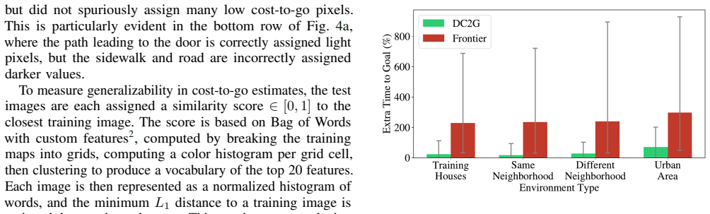
The paper's central claim is that the abstract notion of context for planning can be made operational as a translation between two images: a partial semantic map (the robot's current belief) and a cost-to-go map (a per-cell estimate of the shortest distance to the high-level goal). DC2G, Deep Cost-to-Go, trains a U-Net generator offline on pairs produced by computing exact cost-to-go with Dijkstra on annotated satellite maps and masking them with simulated observation patterns, then uses the network's output online to rank frontier-expanding cells for a frontier-based explorer. Because the output is a full cost-to-go image rather than a single predicted goal location, it can serve as a receding-horizon heuristic and be combined with local collision avoidance. The paper reports that this scheme reaches the goal within 63% of optimal on 42 held-out houses and is 189% faster than pure frontier exploration, and demonstrates the full pipeline on a vehicle with a forward-facing RGB-D and semantic camera in a high-fidelity Unreal simulation.
Load-bearing premise
The method assumes that the artificially masked maps used in training look like the partial maps a real robot builds from its camera and SLAM system, and that front doors in new neighborhoods sit in the same driveway-and-walkway context as the training houses.
Editorial extensions
If this is right
- A robot with no prior map can use learned terrain context to bias exploration toward a semantic goal, so delivery destinations can be specified as high-level concepts like "front door" instead of coordinates.
- The approach transfers from static satellite-derived training data to a forward-facing camera pipeline in simulation, suggesting the same context signal survives realistic noisy semantic maps.
- Because the learned output is a cost-to-go image rather than an action, the planner can be paired with standard local collision avoidance and can report failure if no frontier remains, which end-to-end policies cannot do.
- The method degrades gracefully: if context misleads, the robot still eventually explores all frontiers, whereas an end-to-end learned policy could get stuck.
- The planner generalizes to houses and neighborhoods not seen in training, including an urban neighborhood, though performance drops when layouts differ from training.
Reading between the lines
- The same cost-to-go translation frame should apply to other structured outdoor goals, such as mailboxes, loading docks, or parking entrances, as long as their terrain adjacency statistics are stable and can be labeled in overhead imagery; this is a testable extension the paper does not run.
- The real generalization condition hidden in the method is that front-door context is mostly terrain adjacency, so neighborhoods that violate that adjacency, such as alley-loaded houses or courtyard entrances, would require retraining or fallback to pure exploration.
- A practical improvement suggested by the paper's own similarity analysis would be to weigh the learned heuristic by its estimated reliability: when the current map is far from the training distribution, decay toward frontier exploration, bounding worst-case performance.
- Satellite imagery plus manual semantic annotation may be a general low-cost substitute for simulator interaction in other outdoor robot learning tasks, since the paper shows the learned representation transfers across data formats.
Signed reviews
Editorial analysis
A structured set of objections, weighed in public.
Referee Report
Summary. The paper proposes DC2G, a planner for last-mile delivery to an unknown goal (a house's front door) using only a partial semantic gridmap built online. Context is captured by training a U-Net/GAN image-to-image translator offline on pairs of masked partial semantic maps and masked Dijkstra cost-to-go maps derived from satellite imagery of real houses. At run time, the planner selects the reachable frontier cell with the highest estimated cost-to-go, then executes a shortest path to that cell. The main evaluation is a gridworld simulation over 42 test houses from Bing Maps, reporting that DC2G reaches the goal within 63% of optimal and 189% faster than frontier-based exploration; a qualitative Unreal Engine demonstration with a forward-facing camera is also included. The paper is clearly written, releases source code, and frames the training as using a static dataset rather than a simulator.
Significance. If the empirical claim holds, the paper offers a practical way to inject terrain context into exploration without pre-mapping, and the image-to-image formulation is a clean reduction of the context-utilization problem. The cost-to-go representation is more informative for planning than a single goal-point estimate, and the evaluation across 42 real house layouts is more extensive than many single-scene robotics demos. The open-source release and the use of a satellite-derived static dataset are concrete strengths, and the authors are candid about the task-specific nature of context. However, the central quantitative result depends on an unstated match between the training-mask distribution and the online observation process, and the headline averages are reported without variance or significance tests. The Unreal transfer demonstration is qualitative, so the deployment claim is supported only weakly. The circularity burden is low because the network is trained on Dijkstra ground truth and evaluated on held-out houses with no parameters fitted to the final planner result.
major comments (3)
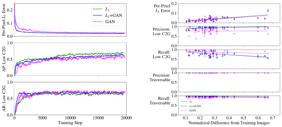
- [Section III-A, Algorithm 1; Section IV-B] The paper never specifies how the 256 observation masks M are generated, although this is the only mechanism that aligns the offline training distribution with the partial maps the planner sees online. In Section IV-B the online maps are accumulated from a 90-degree, 8-cell field of view along the robot's actual trajectory, so the training masks should be visibility wedges anchored at feasible robot poses with matching range and FOV. If the masks are instead sampled as arbitrary contiguous occlusions, the network can be well calibrated on the training masks but miscalibrated on the planner's true inputs, which would make the frontier ranking in Algorithm 2 unreliable even if per-pixel L1 error on full maps is low. Please state the exact mask-generation procedure and add a quantitative comparison, e.g., a distribution-distance measure or an ablation in which training masks are drawn from the online FOV process.
- [Section IV-B, Fig. 7] The headline result 'DC2G reaches the goal within 63% of optimal, and 189% faster than Frontier on average' is reported as a single average over 42 houses with no error bars, confidence intervals, or significance test. The text states that random starts are selected 100 times per neighborhood, so the data contain enough trials for a paired statistical comparison. Please report per-house and aggregate distributions with uncertainty, and perform a paired test (e.g., Wilcoxon signed-rank) against Frontier. Without this, the 189% figure cannot be distinguished from sampling noise, especially because Fig. 7 groups results by neighborhood without showing variability.
- [Section III-A] The dataset counts are internally inconsistent. With 31 train, 4 validation, and 42 test houses and 256 masks per house, the expected number of pairs is 7936, 1024, and 10752, respectively, yet the text reports 7936 train, 320 validation, and 615 test pairs. The test-pair count is not an integer multiple of 42 (615 = 41 × 15), so either the number of test houses, the number of masks, or the pair counts are misreported. This makes the exact composition of the evaluation set unclear and should be corrected.
minor comments (5)
- [Section IV-A.1] There is a typo, 'acheives', in the discussion of the GAN loss.
- [Abstract and Section IV-B] The phrase 'within 63% of optimal' is ambiguous because the metric defined in Section IV-B is percent extra time beyond the oracle path, (%te_goal). Recommend rewording to something like 'on average 63% longer than the optimal path'.
- [Section IV-D] The Unreal Engine demonstration is qualitative; reporting a quantitative success metric, such as completion rate and path-length ratio relative to an oracle, would strengthen the claim that the approach transfers to camera-built semantic maps.
- [Section IV-E] The statement that Frontier outperformed DC2G on 2/77 houses should be reconciled with the test-set claim of 42 houses; if the statistic includes training or validation houses, that should be stated explicitly.
- [Section III-C] The online mapping module is cited to a GitHub repository [32]; a peer-reviewed citation for semantic SLAM or a more detailed description of the projection would improve reproducibility.
Circularity Check
No significant circularity: the learned cost-to-go is trained on independently computed Dijkstra targets and evaluated on held-out houses; no final planner result is fitted.
full rationale
The paper's derivation chain is self-contained and empirically testable. Training data are produced by Algorithm 1: a manually annotated satellite-derived semantic map is separated into traversable and non-traversable regions, the ground-truth cost-to-go is computed by Dijkstra's algorithm from the goal, and 256 observation masks are applied to create partial-map training pairs (Section III-A). The network is then trained offline to translate the masked semantic map into the masked cost-to-go image (Section III-B). At planning time, the DC2G planner feeds the robot's current partial semantic map into the fixed network and uses the estimated cost-to-go to rank frontier-expanding cells (Algorithm 2). The headline result in Section IV-B is an average over 42 test houses whose layouts and masks were not used in training, measured against a frontier-exploration baseline and an oracle with a prior map. No parameter is fitted to the final planner result, and no claimed prediction is equivalent by construction to the training objective. The only substantive concern is distributional: whether the Algorithm 1 masks truly match the partial maps produced online by the forward-facing camera and semantic SLAM pipeline. That is a generalization risk about unseen sensor distributions, not a circularity, because the training targets and evaluation metric are independently defined. Self-citations are not load-bearing: reference [22] motivates U-Nets for context extraction but the planner's success is not derived from it. Therefore the paper warrants a circularity score of 0.
Assumptions & free parameters
free parameters (3)
- U-Net encoder-decoder weights =
Learned on 7,936 training image pairs (not enumerated)
- Observation masks per training map =
256
- Gridworld sensor FOV and range =
90 degrees horizontal, 8-cell radial range
assumptions (5)
- domain assumption Traversability is determined by terrain class in the semantic map, with roads and driveways traversable and grass and houses not.
- domain assumption The 256 synthetic observation masks per map produce training pairs representative of partial maps the robot will see online.
- domain assumption Online semantic SLAM maps from a forward-facing RGB-D camera are close enough to the clean training maps for the trained network to transfer.
- standard math Dijkstra's algorithm on the traversable grid gives the true cost-to-go to the goal.
- domain assumption Front doors have consistent contextual structure, such as driveway and walkway adjacency to roads, across the 42 test houses.
Cite this review
Pith. "Pith review of Planning Beyond the Sensing Horizon Using a Learned Context." pith.science (2026). https://pith.science/paper/YK2D4H76
@misc{pith2026190809171,
  author       = {Pith},
  title        = {Pith review of: Planning Beyond the Sensing Horizon Using a Learned Context},
  year         = {2026},
  howpublished = {\url{https://pith.science/paper/YK2D4H76}},
  note         = {Machine review of arXiv:1908.09171}
}
read the original abstract
Last-mile delivery systems commonly propose the use of autonomous robotic vehicles to increase scalability and efficiency. The economic inefficiency of collecting accurate prior maps for navigation motivates the use of planning algorithms that operate in unmapped environments. However, these algorithms typically waste time exploring regions that are unlikely to contain the delivery destination. Context is key information about structured environments that could guide exploration toward the unknown goal location, but the abstract idea is difficult to quantify for use in a planning algorithm. Some approaches specifically consider contextual relationships between objects, but would perform poorly in object-sparse environments like outdoors. Recent deep learning-based approaches consider context too generally, making training/transferability difficult. Therefore, this work proposes a novel formulation of utilizing context for planning as an image-to-image translation problem, which is shown to extract terrain context from semantic gridmaps, into a metric that an exploration-based planner can use. The proposed framework has the benefit of training on a static dataset instead of requiring a time-consuming simulator. Across 42 test houses with layouts from satellite images, the trained algorithm enables a robot to reach its goal 189\% faster than with a context-unaware planner, and within 63\% of the optimal path computed with a prior map. The proposed algorithm is also implemented on a vehicle with a forward-facing camera in a high-fidelity, Unreal simulation of neighborhood houses.
Figures


Figures from the paper (5 more)



Reference graph
Works this paper leans on
-
[1]
Frontier-based exploration using multiple robots,
B. Yamauchi, “Frontier-based exploration using multiple robots,” in Proceedings of the second international conference on Autonomous agents. ACM, 1998, pp. 47–53
work page 1998
-
[2]
Information gain-based exploration using rao-blackwellized particle filters
C. Stachniss, G. Grisetti, and W. Burgard, “Information gain-based exploration using rao-blackwellized particle filters.” in Robotics: Science and Systems , vol. 2, 2005, pp. 65–72
work page 2005
-
[3]
Learning search heuristics for finding objects in structured environments,
D. Joho, M. Senk, and W. Burgard, “Learning search heuristics for finding objects in structured environments,” Robotics and Autonomous Systems, vol. 59, no. 5, pp. 319–328, 2011
work page 2011
-
[4]
Using the web to interactively learn to find objects
M. Samadi, T. Kollar, and M. M. Veloso, “Using the web to interactively learn to find objects.” in AAAI, 2012, pp. 2074–2080
work page 2012
-
[5]
Utilizing object-object and object-scene context when planning to find things,
T. Kollar and N. Roy, “Utilizing object-object and object-scene context when planning to find things,” in Robotics and Automation, 2009. ICRA’09. IEEE International Conference on . IEEE, 2009, pp. 2168– 2173
work page 2009
-
[6]
Bootstrapping probabilistic models of qualitative spatial relations for active visual object search,
L. Kunze, C. Burbridge, and N. Hawes, “Bootstrapping probabilistic models of qualitative spatial relations for active visual object search,” in AAAI Spring Symposium , 2014, pp. 24–26
work page 2014
-
[7]
Using qualitative spatial relations for indirect object search,
L. Kunze, K. K. Doreswamy, and N. Hawes, “Using qualitative spatial relations for indirect object search,” in Robotics and Automation (ICRA), 2014 IEEE International Conference on . IEEE, 2014, pp. 163–168
work page 2014
-
[8]
Prior-assisted propagation of spatial information for object search,
M. Lorbach, S. H ¨ofer, and O. Brock, “Prior-assisted propagation of spatial information for object search,” in Intelligent Robots and Systems (IROS 2014), 2014 IEEE/RSJ International Conference on . IEEE, 2014, pp. 2904–2909
work page 2014
Show all 34 references
-
[9]
Learning to locate from demonstrated searches
P. Vernaza and A. Stentz, “Learning to locate from demonstrated searches.” in Robotics: Science and Systems , 2014
2014
-
[10]
Active visual object search in unknown environments using uncertain seman- tics,
A. Aydemir, A. Pronobis, M. G ¨obelbecker, and P. Jensfelt, “Active visual object search in unknown environments using uncertain seman- tics,” IEEE Transactions on Robotics , vol. 29, no. 4, pp. 986–1002, 2013
2013
-
[11]
Robot task planning and explanation in open and uncertain worlds,
M. Hanheide, M. G ¨obelbecker, G. S. Horn, A. Pronobis, K. Sj ¨o¨o, A. Aydemir, P. Jensfelt, C. Gretton, R. Dearden, M. Janicek, et al. , “Robot task planning and explanation in open and uncertain worlds,” Artificial Intelligence, vol. 247, pp. 119–150, 2017
2017
-
[12]
Deepnav: Learning to navigate large cities,
S. Brahmbhatt and J. Hays, “Deepnav: Learning to navigate large cities,” in Proc. IEEE Conf. Comput. Vis. Pattern Recognit. , 2017, pp. 3087–3096
2017
-
[14]
Following high-level navigation instructions on a simulated quadcopter with imitation learning,
V . Blukis, N. Brukhim, A. Bennett, R. A. Knepper, and Y . Artzi, “Following high-level navigation instructions on a simulated quadcopter with imitation learning,” arXiv preprint arXiv:1806.00047 , 2018
2018 arXiv
-
[15]
Target-driven Visual Navigation in Indoor Scenes using Deep Reinforcement Learning,
Y . Zhu, R. Mottaghi, E. Kolve, J. J. Lim, A. Gupta, L. Fei-Fei, and A. Farhadi, “Target-driven Visual Navigation in Indoor Scenes using Deep Reinforcement Learning,” in IEEE International Conference on Robotics and Automation , 2017
2017
-
[16]
Visual semantic planning using deep successor representations,
Y . Zhu, D. Gordon, E. Kolve, D. Fox, L. Fei-Fei, A. Gupta, R. Mottaghi, and A. Farhadi, “Visual semantic planning using deep successor representations,” in Proceedings of the IEEE International Conference on Computer Vision , 2017, pp. 483–492
2017
-
[17]
Iqa: Visual question answering in interactive environments,
D. Gordon, A. Kembhavi, M. Rastegari, J. Redmon, D. Fox, and A. Farhadi, “Iqa: Visual question answering in interactive environments,” in Proceedings of the IEEE Conference on Computer Vision and Pattern Recognition, 2018, pp. 4089–4098
2018
-
[18]
Cognitive mapping and planning for visual navigation,
S. Gupta, J. Davidson, S. Levine, R. Sukthankar, and J. Malik, “Cognitive mapping and planning for visual navigation,” in Proceedings of the IEEE Conference on Computer Vision and Pattern Recognition , 2017, pp. 2616–2625
2017
-
[19]
Em- bodied Question Answering,
A. Das, S. Datta, G. Gkioxari, S. Lee, D. Parikh, and D. Batra, “Em- bodied Question Answering,” in Proceedings of the IEEE Conference on Computer Vision and Pattern Recognition (CVPR) , 2018
2018
-
[20]
U-net: Convolutional net- works for biomedical image segmentation,
O. Ronneberger, P. Fischer, and T. Brox, “U-net: Convolutional net- works for biomedical image segmentation,” in International Conference on Medical image computing and computer-assisted intervention . Springer, 2015, pp. 234–241
2015
-
[21]
Image-to-image translation with conditional adversarial networks,
P. Isola, J.-Y . Zhu, T. Zhou, and A. A. Efros, “Image-to-image translation with conditional adversarial networks,” CVPR, 2017
2017
-
[22]
Learning deep generative spatial models for mobile robots,
A. Pronobis and R. P. Rao, “Learning deep generative spatial models for mobile robots,” in Intelligent Robots and Systems (IROS), 2017 IEEE/RSJ International Conference on . IEEE, 2017, pp. 755–762
2017
-
[23]
High-speed autonomous navigation of unknown environments using learned probabilities of collision,
C. Richter, J. Ware, and N. Roy, “High-speed autonomous navigation of unknown environments using learned probabilities of collision,” in 2014 IEEE International Conference on Robotics and Automation (ICRA), May 2014, pp. 6114–6121
2014
-
[24]
Learning to plan for visibility in navigation of unknown environments,
C. Richter and N. Roy, “Learning to plan for visibility in navigation of unknown environments,” in 2016 International Symposium on Experimental Robotics , D. Kuli ´c, Y . Nakamura, O. Khatib, and G. Venture, Eds. Cham: Springer International Publishing, 2017, pp. 387–398
2016
-
[25]
Richter, W
C. Richter, W. Vega-Brown, and N. Roy, Bayesian Learning for Safe High-Speed Navigation in Unknown Environments . Cham: Springer International Publishing, 2018, pp. 325–341. [Online]. Available: https://doi.org/10.1007/978-3-319-60916-4 19
2018 doi
-
[26]
Learning heuristic search via imitation,
M. Bhardwaj, S. Choudhury, and S. Scherer, “Learning heuristic search via imitation,” arXiv preprint arXiv:1707.03034 , 2017
2017 arXiv
-
[28]
Image-to-image translation in tensorflow,
C. Hesse, “Image-to-image translation in tensorflow,” https://affinelayer. com/pix2pix/, accessed: 2018-08-28
2018
-
[29]
A note on two problems in connexion with graphs,
E. W. Dijkstra, “A note on two problems in connexion with graphs,” Numerische mathematik, vol. 1, no. 1, pp. 269–271, 1959
1959
-
[30]
Bing maps,
Microsoft, “Bing maps,” https://www.bing.com/maps, accessed: 2019- 03-01
2019
-
[31]
Mask r-cnn,
K. He, G. Gkioxari, P. Doll ´ar, and R. Girshick, “Mask r-cnn,” IEEE transactions on pattern analysis and machine intelligence , 2018
2018
-
[32]
Real-time voxel based 3d semantic mapping with a hand held rgb-d camera,
Z. Xuan and F. David, “Real-time voxel based 3d semantic mapping with a hand held rgb-d camera,” https://github.com/floatlazer/semantic slam, 2018
2018
-
[33]
Improved techniques for training gans,
T. Salimans, I. Goodfellow, W. Zaremba, V . Cheung, A. Radford, and X. Chen, “Improved techniques for training gans,” in Advances in Neural Information Processing Systems , 2016, pp. 2234–2242
2016
-
[34]
Minimalistic gridworld environment for openai gym,
L. W. Maxime Chevalier-Boisvert, “Minimalistic gridworld environment for openai gym,” https://github.com/maximecb/gym-minigrid, 2018
2018
-
[35]
Airsim: High-fidelity visual and physical simulation for autonomous vehicles,
S. Shah, D. Dey, C. Lovett, and A. Kapoor, “Airsim: High-fidelity visual and physical simulation for autonomous vehicles,” in Field and service robotics. Springer, 2018, pp. 621–635
2018
-
[2018]
Available: http://arxiv.org/abs/1801.02209
[Online]. Available: http://arxiv.org/abs/1801.02209
Reviewed August 14, 2026 · model on record in the stance chip above.
Discussion (0). Continue with ORCID to comment.