REVIEW 5 major objections 5 minor 38 references
PEnG: Pose-Enhanced Geo-Localisation
T0 review · 5 major / 5 minor · reviewed 2026-08-12 · deepseek-v4-flash
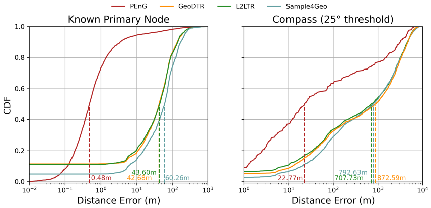
Pith's one-line read PEnG combines cross-view geo-localisation with relative pose estimation to cut median street-view localisation error in Manhattan from 734 m to 22.77 m, a 96.9% reduction.
desk verdict The architectural idea is new and the ablation is honest, but the headline 22.77m median may be inflated by self-retrieval because the paper never states a query/reference split. read the letter →
The pith
A machine-rendered reading of the paper's core claim, the machinery that carries it, and where it could break.
The reading
What carries the argument
The load-bearing object is a city graph \(G=(N,Q,E)\) with two node classes: primary nodes \(N\) at road junctions and secondary nodes \(Q\) placed at intervals along the edges \(E\) that connect junctions. This graph densifies the reference set (median adjacent-secondary-node spacing 9.83 m, versus 116 m between primary nodes) and gives every edge a known yaw, which is what makes the second stage possible. Stage 1 is graph-based cross-view retrieval over primary-node satellite embeddings; stage 2 is relative pose estimation along candidate edges, where a transformer network predicts dense 3D pointmaps for image pairs, RANSAC+PnP solves the relative pose, and the result is scored against a precomputed median edge rotation ('pose prior') using a weighted [1, 0.25, 1] X/Y/Z rotational error. The argument's force comes from chaining a coarse graph retrieval that prunes the city to a handful of edges with a continuous pose solver that no longer depends on tile spacing.
What would settle it
Take a set of StreetLearn Manhattan queries whose ground-truth positions lie off the road graph (or rotate the query crops so their yaw is not aligned with any adjacent edge), run PEnG, and measure median error; if error stays near the stage-1 retrieval level instead of the reported 22.77 m, the road-edge and yaw assumptions are the load-bearing cause of the gain.
Extended reading notes
Core claim
On the paper's own terms, the discovery is that the two viewpoints already present in cross-view geo-localisation datasets—street-level panoramas and overhead satellite imagery—can be used twice: once for coarse retrieval and once for metric pose refinement, and that this is enough to reach sub-metre accuracy at city scale. PEnG first retrieves candidate road junctions (primary nodes) from a city graph using a siamese CNN embedding, then, for each candidate junction, runs relative pose estimation against densely placed secondary nodes along the connected road edges, using transformer-predicted 3D pointmaps solved by RANSAC and PnP. Precomputed reference poses for each edge ('pose priors') and a compass-style yaw filter narrow the search and stabilise the refinement. The reported outcome is a median error of 22.77 m with 90° horizontal FOV images over a 36.1 km² Manhattan region, compared with 734 m for the best prior method, with the ablation showing each added stage—second pose, pose priors—contributing a measurable improvement.
Load-bearing premise
The method assumes the query image was taken on a mapped road, facing along that road, so the graph provides a matching edge and yaw; if the camera is in a parking lot, alley, or anywhere off the graph, the pose-refinement stage has no edge to work with and the claimed precision cannot be produced.
Editorial extensions
If this is right
- Localisation precision stops being bounded by satellite tile spacing: the secondary-node graph plus continuous pose estimates push the practical resolution of cross-view geo-localisation from hundreds of metres toward metres and, in some queries, centimetres.
- A cheap compass-style yaw filter on candidate edges is claimed to be a broadly applicable precision boost; the paper applies it to all baselines and still reports large gains, so the improvement is not an artifact of unfair comparison.
- The two-stage design is not tied to one first-stage model: results are reported both with a plain ConvNeXt-T retriever and with the SpaGBOL graph-based retriever (PEnG*), and both outperform prior single-stage methods.
- With 90° FOV images the method reaches median 22.77 m and Top-25m recall above 51%, while 70° images give 26.82 m and 120° images degrade to 37.72 m, indicating the pipeline is sensitive to the information/resolution trade-off of the input crop.
- The approach makes camera-only localisation a plausible fallback in GNSS-denied urban canyons: a vehicle with a forward monocular camera and a precomputed city graph could estimate its position without satellite navigation.
Reading between the lines
- Because the compass filter and edge assumption require the query camera to face along a mapped road, real-world deployment would likely need a separate heading estimator; a query with unknown orientation would need to try multiple yaw hypotheses, multiplying the pose-estimation cost.
- The reported comparison augments single-stage baselines with an oracle refinement that matches against ground-truth secondary-node satellite images; the fact that PEnG still wins suggests the pose-estimation stage contributes genuine metric information rather than just denser references, but the gap might shrink on datasets with irregular road geometry or heavier foliage.
- The same stage-2 pose-refinement head could be grafted onto any future cross-view retriever, so the paper's main transferable idea is the separation of discrete graph retrieval from continuous pose refinement rather than the specific CNN backbone.
- A natural stress test is to run PEnG on European cities with irregular junctions and varying building heights: Manhattan's grid gives unusually clean edge yaws and consistent urban canyon geometry, so out-of-distribution graph structures may weaken the edge-scoring step.
Editorial analysis
A structured set of objections, weighed in public.
Referee Report
Summary. The paper proposes PEnG, a two-stage system for city-scale cross-view geo-localisation. Stage 1 uses graph-based cross-view image retrieval on primary road-junction nodes to identify candidate edges; Stage 2 runs relative pose estimation along those edges, using precomputed reference poses of secondary nodes, to output a refined 3-DoF pose. The method is evaluated on the StreetLearn Manhattan dataset with 70°, 90°, and 120° horizontal FOV crops, reporting a median euclidean error of 22.77 m at 90° FOV versus a previous best of 734 m, a Top-5m accuracy of 29.18%, and a 96.90% reduction in median error. An ablation study attributes the improvement to the pose-refinement stages and to precomputing reference poses.
Significance. If the reported results hold, PEnG would be a substantial advance in precision for cross-view geo-localisation, demonstrating that combining coarse retrieval with relative pose estimation can overcome the tile-spacing limits of pure retrieval. The paper includes a clear ablation, a sensible compass-filtering heuristic, and a promise of code release and pretrained weights, which would aid reproducibility. The main contributions are empirically grounded and the headline improvement is large, but the evaluation protocol currently contains ambiguities and unfair baseline augmentations that need to be resolved before the central claim can be accepted at face value.
major comments (5)
- [Section IV-A and Section III-B] The paper never states whether the query images are excluded from the reference graph. Section IV-A says all 53,289 StreetLearn images are converted into a graph, and Section III-B builds the reference database from this graph and runs relative pose estimation 'against all reference images' on candidate edges. If a query image is itself a graph node on the selected edge, then Stage 2 can match the query to its own streetview/satellite pair, producing a zero-baseline pose estimate. This would directly inflate the Top-1m/Top-5m values and the median-error improvement. The authors must specify the exact query/reference split, or explicitly state that every query is a held-out image not present in the graph, and ideally report leave-one-out or disjoint-set results.
- [Section IV-D] The comparison baseline is unfair as stated: 'we augment these baselines with a secondary refinement stage where the same technique is run again, but only required to match against the ground-truth satellite images of the corresponding secondary nodes.' This gives the baselines oracle knowledge of the correct secondary node, which is infeasible in real operation. The headline claim of a 96.90% reduction from the previous best of 734 m is therefore a comparison against an oracle-boosted baseline, not against the published performance of those methods. The authors should also report results against the standard, unmodified baseline protocols, or clearly label the oracle-augmented numbers as a separate upper-bound comparison.
- [Abstract and Section IV-D] The abstract's claim of 'enhance precision to a sub-metre level' is an overstatement of the reported results. The median error is 22.77 m and Top-1m accuracy is 9.12%, so sub-metre localisation applies only to a minority of queries. The phrase should be qualified as 'some examples achieve sub-metre or centimetre-level accuracy' or similar, consistent with the data in Table II.
- [Section III-A and Section III-B] The method implicitly assumes that every query image is captured on a road segment represented as an edge in the graph, with the camera facing along the road. This is stated in the methodology but the coverage limitation is never acknowledged or tested. The authors should explicitly state that the method cannot localise queries that lie off the graph (e.g., parking lots, alleys, or newly constructed roads) and evaluate what fraction of typical urban queries fall inside the graph coverage, or provide a failure analysis for such cases.
- [Tables I and II] No error bars, confidence intervals, or repeated-run statistics are reported anywhere in the evaluation. The headline numbers are single-point estimates from a single evaluation pass, and the system contains stochastic components (training, RANSAC, pose optimisation). The authors should report variance across at least a few seeds or provide per-query error distributions with confidence intervals, especially for the 22.77 m median and the Top-K percentages in Tables I and II.
minor comments (5)
- [Section IV-D] The text contains a typographical duplicate percent sign in '96.90%% reduction' and 'approx 213%% increase'.
- [Section III-A] There is a typo in the set notation 'i ∈ {M anhattan, ...}' where 'M anhattan' should be 'Manhattan'.
- [Section V] The conclusion says the method reduces median distance errors 'to often centimetre level accuracy', but the data show only a small fraction of queries reach centimetre accuracy; this statement should be softened to match the quantitative results.
- [Figure 6] The CDF plot would be easier to interpret if the x-axis were shown in log scale, since the vast majority of mass is below 100 m and the differences among methods near zero are not visible on the current linear scale.
- [Section II-B] The related-work section mentions SpaGBOL and BEV-CV, which are the authors' own prior works, but it does not clearly distinguish which components of PEnG are newly proposed relative to those papers until Section III. A short sentence in Section II-B stating the novelty of the two-stage pose-refinement idea would help the reader.
Circularity Check
Headline median error is partly forced by construction: the query streetview is never excluded from the graph/reference set used for relative-pose estimation, so RPE can match a query to itself.
-
fitted input called prediction
[Section III-B (PEnG Procedure, Algorithm 1) and Section IV-A (Datasets)]
""Position along an edge is estimated against all reference images" ... "I pairs = exhaustive(Ecand + I street)" ... "The city's data are converted from unconnected images into a graph representation. This contains 53,289 images, comprising 2,622 primary nodes and 50,667 secondary nodes.""
The graph is built from all StreetLearn images and no query/reference split or leave-one-out exclusion is reported. Algorithm 1 pairs the query streetview with all reference images on candidate edges. Since every query image is one of the 53,289 graph nodes (50,667 of them secondary), the pair (query, query) is available whenever the correct edge is a candidate. Relative pose estimation on an identical image pair returns identity rotation and zero translation, so the predicted position is the query's own graph position by construction. The paper criticises previous works for '0m error when they correctly retrieve the corresponding correct satellite image' but never states how PEnG avoids the analogous self-match in its streetview-to-streetview RPE stage.
full rationale
The system itself is not a derivation from a fitted parameter; it is a learned two-stage pipeline evaluated on StreetLearn. However, the evaluation protocol creates a construction-level circularity for the headline numbers: the reference gallery for the relative-pose stage is the full set of graph nodes, with no stated removal of the query. Because RPE compares streetview images to streetview reference images, a query that is itself a node can be paired with itself, yielding an exact pose by construction. This is a form of fitted-input-called-prediction: the reference set contains the ground-truth image for most queries, so the reported precision is partly forced rather than measured on unseen poses. The self-citations to SpaGBOL and BEV-CV are present but not load-bearing for the main comparison, which also uses external baselines (L2LTR, GeoDTR+, Sample4Geo). The off-graph coverage limitation is an assumption, not a circularity. If a future version documents a query/reference split and excludes the query from RPE references, the circularity concern would be resolved; as written, the paper does not report such a split.
Assumptions & free parameters
free parameters (6)
- confidence_threshold_theta_c =
0.9
- median_pose_error_threshold_theta_re =
3 degrees
- yaw_filter_threshold =
not specified
- rotational_error_axis_weights =
[1, 0.25, 1]
- max_candidates_k =
not specified
- secondary_node_sampling_density =
median spacing 9.83m
assumptions (4)
- domain assumption The query street-view image is captured on a road segment that is present as an edge in the city graph.
- domain assumption The camera yaw (north-aligned heading) is known for both query and reference images.
- domain assumption Relative pose estimation (Mast3r) trained on generic image collections transfers to limited-FOV street-view crops with sufficient accuracy.
- domain assumption The graph representation and satellite images are geographically aligned to the query street-view images.
Cite this review
Pith. "Pith review of PEnG: Pose-Enhanced Geo-Localisation." pith.science (2026). https://pith.science/paper/RVAUVMK6
@misc{pith2026241115742,
  author       = {Pith},
  title        = {Pith review of: PEnG: Pose-Enhanced Geo-Localisation},
  year         = {2026},
  howpublished = {\url{https://pith.science/paper/RVAUVMK6}},
  note         = {Machine review of arXiv:2411.15742}
}
read the original abstract
Cross-view Geo-localisation is typically performed at a coarse granularity, because densely sampled satellite image patches overlap heavily. This heavy overlap would make disambiguating patches very challenging. However, by opting for sparsely sampled patches, prior work has placed an artificial upper bound on the localisation accuracy that is possible. Even a perfect oracle system cannot achieve accuracy greater than the average separation of the tiles. To solve this limitation, we propose combining cross-view geo-localisation and relative pose estimation to increase precision to a level practical for real-world application. We develop PEnG, a 2-stage system which first predicts the most likely edges from a city-scale graph representation upon which a query image lies. It then performs relative pose estimation within these edges to determine a precise position. PEnG presents the first technique to utilise both viewpoints available within cross-view geo-localisation datasets to enhance precision to a sub-metre level, with some examples achieving centimetre level accuracy. Our proposed ensemble achieves state-of-the-art precision - with relative Top-5m retrieval improvements on previous works of 213%. Decreasing the median euclidean distance error by 96.90% from the previous best of 734m down to 22.77m, when evaluating with 90 degree horizontal FOV images. Code will be made available: tavisshore.co.uk/PEnG
Figures


Figures from the paper (2 more)

Reference graph
Works this paper leans on
-
[1]
The streetlearn environment and dataset, 2019
Piotr Mirowski, Andras Banki-Horvath, Keith Anderson, De- nis Teplyashin, Karl Moritz Hermann, Mateusz Malinowski, Matthew Koichi Grimes, Karen Simonyan, Koray Kavukcuoglu, An- drew Zisserman, and Raia Hadsell. The streetlearn environment and dataset, 2019
work page 2019
-
[2]
Monocular Vision for Mobile Robot Localization and Autonomous Navigation
Eric Royer, Maxime Lhuillier, Michel Dhome, and Jean-Marc Lavest. Monocular Vision for Mobile Robot Localization and Autonomous Navigation. International Journal of Computer Vision, 74(3):237–260, 2007
work page 2007
-
[3]
From structure-from-motion point clouds to fast location recognition
Arnold Irschara, Christopher Zach, Jan-Michael Frahm, and Horst Bischof. From structure-from-motion point clouds to fast location recognition. In 2009 IEEE Conference on Computer Vision and Pattern Recognition, pages 2599–2606, 2009
work page 2009
-
[4]
Efficient & ef- fective prioritized matching for large-scale image-based localization
Torsten Sattler, Bastian Leibe, and Leif Kobbelt. Efficient & ef- fective prioritized matching for large-scale image-based localization. IEEE Transactions on Pattern Analysis and Machine Intelligence , 39(9):1744–1756, 2017
work page 2017
-
[5]
Scene coordinate regression forests for camera relocalization in rgb-d images
Jamie Shotton, Ben Glocker, Christopher Zach, Shahram Izadi, An- tonio Criminisi, and Andrew William Fitzgibbon. Scene coordinate regression forests for camera relocalization in rgb-d images. 2013 IEEE Conference on Computer Vision and Pattern Recognition , pages 2930–2937, 2013
work page 2013
-
[6]
Posenet: A convolutional network for real-time 6-dof camera relocalization
Alex Kendall, Matthew Grimes, and Roberto Cipolla. Posenet: A convolutional network for real-time 6-dof camera relocalization. In Proceedings of the IEEE international conference on computer vision , pages 2938–2946, 2015
work page 2015
-
[7]
Geometric loss functions for camera pose regression with deep learning, 2017
Alex Kendall and Roberto Cipolla. Geometric loss functions for camera pose regression with deep learning, 2017
work page 2017
-
[8]
Dsac - differen- tiable ransac for camera localization, 2018
Eric Brachmann, Alexander Krull, Sebastian Nowozin, Jamie Shotton, Frank Michel, Stefan Gumhold, and Carsten Rother. Dsac - differen- tiable ransac for camera localization, 2018
work page 2018
Show all 38 references
-
[9]
Vidloc: A deep spatio-temporal model for 6-dof video- clip relocalization, 2017
Ronald Clark, Sen Wang, Andrew Markham, Niki Trigoni, and Hongkai Wen. Vidloc: A deep spatio-temporal model for 6-dof video- clip relocalization, 2017
2017
-
[10]
From coarse to fine: Robust hierarchical localization at large scale
Paul-Edouard Sarlin, Cesar Cadena, Roland Siegwart, and Marcin Dymczyk. From coarse to fine: Robust hierarchical localization at large scale. In CVPR, 2019
2019
-
[11]
Map-free visual relocalization: Metric pose relative to a single image
Eduardo Arnold, Jamie Wynn, Sara Vicente, Guillermo Garcia- Hernando, ´Aron Monszpart, Victor Adrian Prisacariu, Daniyar Tur- mukhambetov, and Eric Brachmann. Map-free visual relocalization: Metric pose relative to a single image. In ECCV, 2022
2022
-
[12]
Chris Rockwell, Nilesh Kulkarni, Linyi Jin, Jeong Joon Park, Justin Johnson, and David F. Fouhey. Far: Flexible, accurate and robust 6dof relative camera pose estimation. In CVPR, 2024
2024
-
[13]
Dust3r: Geometric 3d vision made easy
Shuzhe Wang, Vincent Leroy, Yohann Cabon, Boris Chidlovskii, and Jerome Revaud. Dust3r: Geometric 3d vision made easy. In CVPR, 2024
2024
-
[14]
Grounding image matching in 3d with mast3r, 2024
Vincent Leroy, Yohann Cabon, and J ´erˆome Revaud. Grounding image matching in 3d with mast3r, 2024
2024
-
[15]
Crossfire: Camera relocalization on self-supervised features from an implicit representa- tion
Arthur Moreau, Nathan Piasco, Moussab Bennehar, Dzmitry Tsishkou, Bogdan Stanciulescu, and Arnaud de La Fortelle. Crossfire: Camera relocalization on self-supervised features from an implicit representa- tion. In Proceedings of the IEEE/CVF International Conference on Computer...
2023
-
[16]
Transgeo: Transformer is all you need for cross-view image geo-localization
Sijie Zhu, Mubarak Shah, and Chen Chen. Transgeo: Transformer is all you need for cross-view image geo-localization. 2022 IEEE/CVF Conference on Computer Vision and Pattern Recognition (CVPR) , pages 1152–1161, 2022
2022
-
[17]
Simple, effective and general: A new backbone for cross-view image geo- localization, 2023
Yingying Zhu, Hongji Yang, Yuxin Lu, and Qiang Huang. Simple, effective and general: A new backbone for cross-view image geo- localization, 2023
2023
-
[18]
Bev-cv: Birds-eye- view transform for cross-view geo-localisation, 2023
Tavis Shore, Simon Hadfield, and Oscar Mendez. Bev-cv: Birds-eye- view transform for cross-view geo-localisation, 2023
2023
-
[19]
On the location dependence of convolutional neural network features
Scott Workman and Nathan Jacobs. On the location dependence of convolutional neural network features. In 2015 IEEE Conference on Computer Vision and Pattern Recognition Workshops (CVPRW), pages 70–78, 2015
2015
-
[20]
Learn- ing deep representations for ground-to-aerial geolocalization
Tsung-Yi Lin, Yin Cui, Serge Belongie, and James Hays. Learn- ing deep representations for ground-to-aerial geolocalization. In 2015 IEEE Conference on Computer Vision and Pattern Recognition (CVPR), pages 5007–5015, 2015
2015
-
[21]
V o and James Hays
Nam N. V o and James Hays. Localizing and orienting street views using overhead imagery. In European Conference on Computer Vision, 2016
2016
-
[22]
Sixing Hu, Mengdan Feng, Rang M. H. Nguyen, and Gim Hee Lee. Cvm-net: Cross-view matching network for image-based ground-to- aerial geo-localization. In 2018 IEEE/CVF Conference on Computer Vision and Pattern Recognition , pages 7258–7267, 2018
2018
-
[23]
Netvlad: Cnn architecture for weakly supervised place recognition
Relja Arandjelovi ´c, Petr Gron ´at, Akihiko Torii, Tom ´as Pajdla, and Josef Sivic. Netvlad: Cnn architecture for weakly supervised place recognition. IEEE Transactions on Pattern Analysis and Machine Intelligence, 40:1437–1451, 2015
2015
-
[24]
Lending orientation to neural networks for cross-view geo-localization
Liu Liu and Hongdong Li. Lending orientation to neural networks for cross-view geo-localization. In 2019 IEEE/CVF Conference on Computer Vision and Pattern Recognition (CVPR) , pages 5617–5626, 2019
2019
-
[25]
Spatial-aware feature aggregation for image based cross-view geo-localization
Yujiao Shi, Liu Liu, Xin Yu, and Hongdong Li. Spatial-aware feature aggregation for image based cross-view geo-localization. In Neural Information Processing Systems , 2019
2019
-
[26]
Optimal feature transport for cross-view image geo-localization
Yujiao Shi, Xin Yu, Liu Liu, Tong Zhang, and Hongdong Li. Optimal feature transport for cross-view image geo-localization. ArXiv, 2019
2019
-
[27]
Where am i looking at? joint location and orientation estimation by cross- view matching
Yujiao Shi, Xin Yu, Dylan Campbell, and Hongdong Li. Where am i looking at? joint location and orientation estimation by cross- view matching. 2020 IEEE/CVF Conference on Computer Vision and Pattern Recognition (CVPR), pages 4063–4071, 2020
2020
-
[28]
Coming down to earth: Satellite-to-street view synthesis for geo- localization
Aysim Toker, Qunjie Zhou, Maxim Maximov, and Laura Leal-Taix’e. Coming down to earth: Satellite-to-street view synthesis for geo- localization. 2021 IEEE/CVF Conference on Computer Vision and Pattern Recognition (CVPR), pages 6484–6493, 2021
2021
-
[29]
Hongji Yang, Xiufan Lu, and Ying J. Zhu. Cross-view geo-localization with layer-to-layer transformer. In Neural Information Processing Systems, 2021
2021
-
[30]
Cross-view geo-localization via learning disentangled geo- metric layout correspondence, 2023
Xiaohan Zhang, Xingyu Li, Waqas Sultani, Yi Zhou, and Safwan Wshah. Cross-view geo-localization via learning disentangled geo- metric layout correspondence, 2023
2023
-
[31]
Geodtr+: Toward generic cross-view geolocalization via geometric disentanglement, 2023
Xiaohan Zhang, Xingyu Li, Waqas Sultani, Chen Chen, and Safwan Wshah. Geodtr+: Toward generic cross-view geolocalization via geometric disentanglement, 2023
2023
-
[32]
Sample4geo: Hard negative sampling for cross-view geo-localisation, 2023
Fabian Deuser, Konrad Habel, and Norbert Oswald. Sample4geo: Hard negative sampling for cross-view geo-localisation, 2023
2023
-
[33]
Spagbol: Spatial- graph-based orientated localisation, 2024
Tavis Shore, Oscar Mendez, and Simon Hadfield. Spagbol: Spatial- graph-based orientated localisation, 2024
2024
-
[34]
Fischler and Robert C
Martin A. Fischler and Robert C. Bolles. Random sample consensus: a paradigm for model fitting with applications to image analysis and automated cartography. Commun. ACM, 24(6):381–395, June 1981
1981
-
[35]
Wide-area image geolocalization with aerial reference imagery
Scott Workman, Richard Souvenir, and Nathan Jacobs. Wide-area image geolocalization with aerial reference imagery. In IEEE Inter- national Conference on Computer Vision (ICCV) , pages 1–9, 2015. Acceptance rate: 30.3%
2015
-
[36]
A convnet for the 2020s
Zhuang Liu, Hanzi Mao, Chao-Yuan Wu, Christoph Feichtenhofer, Trevor Darrell, and Saining Xie. A convnet for the 2020s. Proceed- ings of the IEEE/CVF Conference on Computer Vision and Pattern Recognition (CVPR), 2022
2022
-
[37]
Imagenet: A large-scale hierarchical image database
Jia Deng, Wei Dong, Richard Socher, Li-Jia Li, Kai Li, and Li Fei- Fei. Imagenet: A large-scale hierarchical image database. In 2009 IEEE Conference on Computer Vision and Pattern Recognition , pages 248–255, 2009
2009
-
[38]
Cross-view geo- localization with layer-to-layer transformer
Hongji Yang, Xiufan Lu, and Yingying Zhu. Cross-view geo- localization with layer-to-layer transformer. In M. Ranzato, A. Beygelzimer, Y . Dauphin, P.S. Liang, and J. Wortman Vaughan, ed- itors, Advances in Neural Information Processing Systems, volume 34, pages 29009–29020. C...
2021
Reviewed August 12, 2026 · model on record in the stance chip above.
Discussion (0). Continue with ORCID to comment.