REVIEW 3 major objections 6 minor 37 references
The Muon Space GNSS-R Surface Soil Moisture Product
T0 review · 3 major / 6 minor · reviewed 2026-08-12 · deepseek-v4-flash
Pith's one-line read The paper claims a deep learning pipeline trained on SMAP retrievals turns full CYGNSS delay-Doppler maps into an operational soil moisture product that beats the official v1.0 CYGNSS product and matches SMAP in open terrain.
desk verdict A solid, transparent data product paper that deserves review, but the headline accuracy claim rests on a small non-forested validation subset and should be qualified. read the letter →
The pith
A machine-rendered reading of the paper's core claim, the machinery that carries it, and where it could break.
The reading
What carries the argument
The load-bearing object is the CYGNSS L1 v3.2 'power_analog' delay-Doppler map, a $17 \times 11$ array of calibrated reflected power, treated as an image by a convolutional neural network rather than reduced to a peak-power scalar. The network has two residual blocks of $3\times3$ convolutions with leaky ReLU and skip connections, max pooling, a dense featurization layer for the ancillary inputs, concatenation, two dense layers with dropout, and a softmax output that keeps soil moisture nonnegative. Ancillary inputs include topography, NDVI, fractional vegetation water content, fractional land cover, soil texture, surface water fraction, observation geometry, and location, matched at 3 km scale. The training target is SMAP Enhanced L3 9 km soil moisture, with DDMs standardized per spacecraft and filters excluding surface water fraction above 1%, elevations above 3000 m, and DDM SNR below 1 dB.
What would settle it
Use dense in situ soil moisture networks in the Amazon and Congo basins, where SMAP data are flagged 'not recommended'; if the Muon product's ubRMSE there exceeds about $0.04$ to $0.05\ \mathrm{cm^3\,cm^{-3}}$ while its North American core-validation value remains near $0.032\ \mathrm{cm^3\,cm^{-3}}$, the broad claim of SMAP-comparable performance would fail outside the well-validated regions.
Extended reading notes
Core claim
The paper's central claim is that the full CYGNSS delay-Doppler map, not just a scalar reflectivity, carries retrievable soil moisture information when processed by a convolutional network with residual blocks, and that temporally separated training and validation windows prevent the overfitting that random splits produce in correlated GNSS-R tracks. Trained on SMAP Enhanced L3 9 km retrievals from 2021 to 2022, developed on 2023 data, and evaluated on the unseen 2018 through 2020 window, the final model generates L2 trackwise and L3 9 km gridded retrievals. At SMAP core validation sites the upscaled L2 product has mean correlation $0.72$, ubRMSE $0.032\ \mathrm{cm^3\,cm^{-3}}$, and bias $0.02\ \mathrm{cm^3\,cm^{-3}}$, compared with SMAP's correlation $0.85$ and ubRMSE $0.031$, and the official v1.0 CYGNSS product's correlation $0.59$ and ubRMSE $0.035$; the L3 gridded statistics are nearly identical to the L2 values. Ablation results show the largest performance drop when the DDM and all DDM-derived inputs are removed, and noise-injection tests degrade correlation by less than $0.02$.
Load-bearing premise
The load-bearing premise is that SMAP Enhanced L3 retrievals, including regions flagged 'not recommended,' are an unbiased enough training target that the network learns true soil moisture rather than SMAP's systematic errors.
Editorial extensions
If this is right
- A public operational L2 and L3 soil moisture dataset at 3 to 9 km effective resolution is produced from CYGNSS v3.2 data covering August 2018 through at least September 2024.
- In low- to moderately vegetated environments the retrievals approach SMAP's in situ agreement while resolving finer spatial detail, such as irrigated-versus-desert boundaries.
- The product improves on the official v1.0 CYGNSS soil moisture product in mean correlation and effective resolution across most validation sites.
- Forests and mountainous terrain remain a known weak spot, and the L3 product carries quality flags that identify those conditions for users.
- The same pipeline is designed to ingest data from upcoming polar GNSS-R satellites, extending soil moisture coverage beyond CYGNSS's $\pm37^\circ$ latitude band.
Reading between the lines
- Inference: If the claims hold, the full-DDM learning result suggests a GNSS-R constellation can serve as a long-term soil moisture climate record that outlives any single satellite mission.
- Inference: Because the training target is SMAP, the product's skill over the Amazon and Congo basins, where SMAP is flagged 'not recommended,' cannot be inferred from the North American core validation sites; a dedicated in situ evaluation there would test whether the generalization holds.
- Inference: The sharper spatial delineation over agricultural boundaries implies the 3 km ancillary matching may open field-scale agricultural and irrigation monitoring applications that a 36 km product cannot support.
- Inference: The temporal split design itself, with a full-year training window and a held-out earlier validation window, could serve as a template for other geophysical retrievals in the same pipeline, since random track-level splits are demonstrably overfit-prone.
Editorial analysis
A structured set of objections, weighed in public.
Referee Report
Summary. This paper describes an operational GNSS-R surface soil moisture retrieval pipeline developed by Muon Space. The model is a convolutional neural network that takes CYGNSS v3.2 delay-Doppler maps plus ancillary surface and geometry data as inputs and is trained to reproduce SMAP Enhanced L3 9-km radiometer soil moisture. The authors generate L2 trackwise and L3 gridded products, present validation against ISMN sparse networks and SMAP Core Validation Sites (CVS), and compare with the UCAR v1.0 CYGNSS product. The headline result is ubRMSE=0.032 cm3 cm-3 at eight SMAP CVS, with performance approaching SMAP in low/moderate vegetation and degraded in forests/mountains.
Significance. The product fills a practical niche: a public, operational GNSS-R soil moisture dataset at 3-9 km effective resolution, with documented preprocessing, ablation, ensemble uncertainty, and quality flags. The authors are transparent about many limitations, including SMAP target circularity and forest/mountain degradation. However, the strength of the central accuracy claim is limited by the narrow, non-representative validation population used for the headline statistic and by the outdated UCAR baseline used for comparison. With appropriate qualification and a current-baseline comparison, the dataset would be a valuable community resource.
major comments (3)
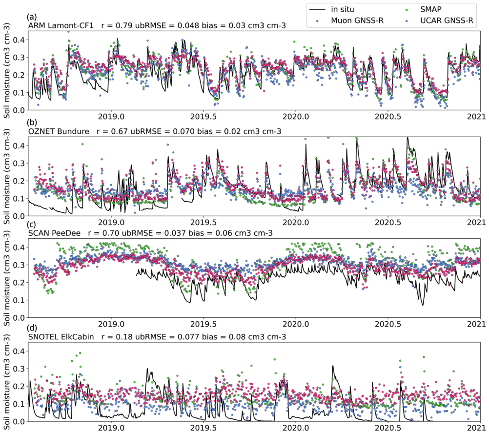
- [Technical Validation (Table 4; Figure 9)] The headline ubRMSE of 0.032 cm3 cm-3 is computed from only eight SMAP CVS, all within the CYGNSS latitude band and none forested, as the paper itself acknowledges. At the ISMN sparse sites the mean correlation is 0.50, compared with 0.72 at the CVS, and forested and mountainous classes show markedly higher ubRMSE and lower correlation (Figure 9d-f). Because the abstract presents 'comparable performance in many regions' and the ubRMSE as the principal accuracy claim, the paper should either re-derive the headline statistic on a validation population that is representative of the intended global domain (e.g., stratified by land cover and topography) or explicitly state that the headline applies only to non-forested, low-relief CVS sites. As written, the evidence supports a narrower claim than the abstract makes.
- [Performance Evaluation and Technical Validation (UCAR comparison)] The claim that the Muon product 'outperforms the official CYGNSS product' is based entirely on the UCAR v1.0 product, which the paper states uses CYGNSS v2.1 data and a 36-km regression, and which has been superseded by a version based on CYGNSS v3.2 and 9-km SMAP data. Comparing against a superseded baseline does not establish superiority over the current official product. The authors should either validate against the current UCAR/CYGNSS product or restrict the claim to 'outperforms the v1.0 UCAR product' in the abstract and conclusions.
- [SMAP Data Filtering / Performance Evaluation] The paper correctly notes that validation against SMAP measures reproduction of SMAP estimates, not true soil moisture, and that errors in the SMAP target are not measurable with their analysis. However, this circularity is load-bearing for the claim of 'comparable performance to SMAP' in regions where SMAP itself is poorly validated, especially because the authors deliberately retain 'not recommended' SMAP retrievals over South America and Central Africa. Please add a quantitative or at least explicit statement of how target bias could affect the in situ validation statistics, and remove or qualify any language suggesting that agreement with SMAP is independent evidence of accuracy.
minor comments (6)
- [Performance Evaluation, Figure 4] 'RSME' should be 'RMSE' in the text and in the figure caption/labels.
- [Data Records, last paragraph] The sentence 'these fields are also updated in the the L2 files' contains a duplicated article and should read 'in the L2 files'.
- [Performance Evaluation, Figure 4 discussion] 'Feburary' should be 'February'.
- [SMAP Data Filtering] 'Roberts at al.' should be 'Roberts et al.'
- [Technical Validation, L3 Retrievals] The sentence 'Table 3 also shows the equivalent statistics for the L3 retrievals at the SMAP CVS' appears to refer to Table 4 (or to a supplemental table); please correct the cross-reference.
- [Figure 5] The right panel is described as showing the 'sensitivity of all the inputs,' but the caption does not define the plotted quantity; adding the exact definition and units of the sensitivity would aid reproducibility.
Circularity Check
No significant circularity: the central accuracy claims are anchored to in situ validation, and the paper explicitly distinguishes SMAP reproduction from true soil moisture.
full rationale
The model is trained to map CYGNSS DDMs and ancillary inputs to SMAP L3 soil moisture, so agreement with SMAP on held-out data is expected as a training sanity check rather than independent evidence. The paper is transparent about this: in Performance Evaluation it states that validation against the target 'is fundamentally a measure of how well the model was trained to reproduce SMAP SM estimates, but it is not necessarily a measure of how well the model outputs true soil moisture.' The headline ubRMSE of 0.032 cm3 cm-3 is computed against SMAP Core Validation Site in situ measurements (Table 4), which are external to the training target. Sparse-network in situ statistics in Figure 9 independently support the more modest claim of comparable performance to SMAP in low- and moderately-vegetated regions, and the paper explicitly acknowledges underperformance in forests and mountainous terrain. Self-citations to Roberts et al. (2022) provide architectural and filtering context but are not load-bearing for the numerical results; the present paper supplies its own in situ validation. The reader's concern that SMAP regional biases may propagate into the product is a legitimate accuracy limitation, but it is not circularity because the product's central quantitative claims are not derived from the SMAP training target alone.
Assumptions & free parameters
free parameters (6)
- CYGNSS DDM SNR threshold =
> 1 dB
- Maximum reflection incidence angle =
65 degrees
- Maximum surface elevation =
3000 m
- Surface water fraction threshold =
< 1%
- Training, development, and validation time windows =
Train 2021-2022, Dev 2023, Val 2018-2020
- Noise perturbation range for sensitivity study =
+/-5% at 90% confidence when variance unknown
assumptions (5)
- domain assumption SMAP Enhanced L3 soil moisture is a valid and sufficiently unbiased training target for near-surface soil moisture.
- domain assumption CYGNSS v3.2 L1 DDMs are calibrated and the quality flags, including the custom RFI flag, correctly identify erroneous measurements.
- domain assumption L-band GNSS-R forward scattering and L-band radiometry respond to similar surface soil moisture and vegetation physics.
- domain assumption In situ point measurements from ISMN and SMAP CVS are representative of soil moisture at 9 to 36 km footprint scales.
- domain assumption Static and climatological ancillary inputs (NDVI, VWC, land cover) are valid for the full retrieval period.
Cite this review
Pith. "Pith review of The Muon Space GNSS-R Surface Soil Moisture Product." pith.science (2026). https://pith.science/paper/RRD66J5Z
@misc{pith2026241200072,
  author       = {Pith},
  title        = {Pith review of: The Muon Space GNSS-R Surface Soil Moisture Product},
  year         = {2026},
  howpublished = {\url{https://pith.science/paper/RRD66J5Z}},
  note         = {Machine review of arXiv:2412.00072}
}
abstract
Muon Space (Muon) is building a constellation of small satellites, many of which will carry global navigation satellite system-reflectometry (GNSS-R) receivers. In preparation for the launch of this constellation, we have developed a generalized deep learning retrieval pipeline, which now produces operational GNSS-R near-surface soil moisture retrievals using data from NASA's Cyclone GNSS (CYGNSS) mission. In this article, we describe the input datasets, preprocessing methods, model architecture, development methods, and detail the soil moisture products generated from these retrievals. The performance of this product is quantified against in situ measurements and compared to both the target dataset (retrievals from the Soil Moisture Active-Passive (SMAP) satellite) and the v1.0 soil moisture product from the CYGNSS mission. The Muon Space product achieves improvements in spatial resolution over SMAP with comparable performance in many regions. An ubRMSE of 0.032 cm$^3$ cm$^{-3}$ for in situ soil moisture observations from SMAP core validation sites is shown, though performance is lower than SMAP's when comparing in forests and/or mountainous terrain. The Muon Space product outperforms the v1.0 CYGNSS soil moisture product in almost all aspects. This initial release serves as the foundation of our operational soil moisture product, which soon will additionally include data from Muon Space satellites.
Figures


Figures from the paper (7 more)


Reference graph
Works this paper leans on
-
[1]
Chew, C. & Small, E. Description of the UCAR/CU Soil Moisture Product.Remote. Sens. 12, 1558–26, 10.3390/rs12101558 (2020). Publisher: Multidisciplinary Digital Publishing Institute
-
[2]
Kim, H. & Lakshmi, V . Use of Cyclone Global Navigation Satellite System (CyGNSS) Observations for Estimation of Soil Moisture. Geophys. Res. Lett. 45, 8272–8282, 10.1029/2018GL078923 (2018)
-
[3]
Eroglu, O., Kurum, M., Boyd, D. & Gurbuz, A. C. High Spatio-Temporal Resolution CYGNSS Soil Moisture Estimates Using Artificial Neural Networks. Remote. Sens. 11, 2272–32, 10.3390/rs11192272 (2019). Publisher: Multidisciplinary Digital Publishing Institute
-
[4]
Evaluations of Machine Learning-Based CYGNSS Soil Moisture Estimates against SMAP Observations
Senyurek, V .et al. Evaluations of Machine Learning-Based CYGNSS Soil Moisture Estimates against SMAP Observations. Remote. Sens. 12, 3503, 10.3390/rs12213503 (2020). Publisher: Multidisciplinary Digital Publishing Institute
-
[5]
M., Colwell, I., Chew, C., Lowe, S
Roberts, T. M., Colwell, I., Chew, C., Lowe, S. & Shah, R. A Deep-Learning Approach to Soil Moisture Estimation with GNSS-R. Remote. Sens. 14, 3299, 10.3390/rs14143299 (2022)
-
[6]
Pierdicca, N., Guerriero, L., Giusto, R., Brogioni, M. & Egido, A. Savers: A simulator of gnss reflections from bare and vegetated soils. IEEE Transactions on Geosci. Remote. Sens. 52, 6542–6554, 10.1109/TGRS.2013.2297572 (2014). 21/23
-
[7]
Clarizia, M. P. & Ruf, C. S. Wind Speed Retrieval Algorithm for the Cyclone Global Navigation Satellite System (CYGNSS) Mission. IEEE Transactions on Geosci. Remote. Sens. 54, 4419–4432, 10.1109/TGRS.2016.2541343 (2016)
arXiv 2016
-
[8]
ONeill, P. E. et al. SMAP Enhanced L3 Radiometer Global and Polar Grid Daily 9 km EASE-Grid Soil Moisture, Version 5, 10.5067/4DQ54OUIJ9DL (2021)
Show all 37 references
-
[9]
Soil Moisture Active Passive (SMAP) Project: Calibration and Validation for the L2/3_sm_p Version 4 and L2/3_sm_p_e Version 1 Data Products
Jackson, T. Soil Moisture Active Passive (SMAP) Project: Calibration and Validation for the L2/3_sm_p Version 4 and L2/3_sm_p_e Version 1 Data Products. JPL Publ. 1–52 (2017)
2017
-
[10]
Cygnss level 1 science data record version 3.2, 10.5067/CYGNS-L1X32 (2024)
CYGNSS. Cygnss level 1 science data record version 3.2, 10.5067/CYGNS-L1X32 (2024)
2024 doi
-
[11]
S., Clarizia, M
Ruf, C., Chang, P. S., Clarizia, M. P., Gleason, S. & Jelenak, Z.CyGNSS handbook. Cyclone global navigation satellite systems (2018)
2018
-
[12]
Peng, J. e. a. Smap ancillary data report. JPL Publ. (2019)
2019
-
[13]
& Belward, A
Pekel, J.-F., Cottam, A., Gorelick, N. & Belward, A. S. High-resolution mapping of global surface water and its long-term changes. Nat. Publ. Group 540, 418–422, 10.1038/nature20584 (2016). Publisher: Nature Publishing Group
2016 doi
-
[14]
SMAP Ancillary Data Report : VWC
Chan, S. SMAP Ancillary Data Report : VWC. Tech. Rep. (2013)
2013
-
[15]
Sulla-Menashe
Friedl, D., M. Sulla-Menashe. Mcd12q1 modis/terra+aqua land cover type yearly l3 global 500m sin grid v006, 10.5067/ MODIS/MCD12Q1.006 (2019)
2019
-
[16]
& Yildirim, E
Hornbuckle, B., Walker, V ., Eichinger, B., Wallace, V . & Yildirim, E. Soil surface roughness observed during smapvex16-ia and its potential consequences for smos and smap. In 2017 IEEE International Geoscience and Remote Sensing Symposium (IGARSS), 2027–2030, 10.1109/IGARSS....
2017
-
[17]
Campbell, J. D. et al. Intercomparison of Electromagnetic Scattering Models for Delay-Doppler Maps Along a CYGNSS Land Track With Topography. IEEE Transactions on Geosci. Remote. Sens. 60, 1–13, 10.1109/TGRS.2022.3210160 (2022)
2022
-
[18]
Al-Khaldi, M. M. et al. An algorithm for detecting coherence in cyclone global navigation satellite system mission level-1 delay-doppler maps. IEEE Transactions on Geosci. Remote. Sens. 59, 4454–4463, 10.1109/TGRS.2020.3009784 (2021)
2021
-
[19]
& Jin, S
Dong, Z. & Jin, S. Evaluation of the Land GNSS-Reflected DDM Coherence on Soil Moisture Estimation from CYGNSS Data. Remote. Sens. 13, 570, 10.3390/rs13040570 (2021)
2021 doi
-
[20]
J., Billingsley, B., Haran, T., Raup, B
Brodzik, M. J., Billingsley, B., Haran, T., Raup, B. & Savoie, M. H. EASE-Grid 2.0: Incremental but Significant Improvements for Earth-Gridded Data Sets. ISPRS Int. J. Geo-Information 1, 32–45, 10.3390/ijgi1010032 (2012)
2012 doi
-
[21]
Flex power on GPS Block IIR-M and IIF
Steigenberger, P. Flex power on GPS Block IIR-M and IIF. GPS Solutions 23, 1–12, 10.1007/s10291-018-0797-8 (2019). Publisher: Springer Berlin Heidelberg
2019 doi
-
[22]
& Wickert, J
Asgarimehr, M., Arnold, C., Weigel, T., Ruf, C. & Wickert, J. GNSS reflectometry global ocean wind speed using deep learning: Development and assessment of CyGNSSnet. Remote. Sens. Environ. 269, 112801, 10.1016/j.rse.2021.112801 (2022)
2022
-
[23]
Smith, L. N. Cyclical learning rates for training neural networks (2017). 1506.01186
2017 arXiv
-
[24]
Dorigo, W. et al. The International Soil Moisture Network: serving Earth system science for over a decade. Hydrol. Earth Syst. Sci. 25, 5749–5804, 10.5194/hess-25-5749-2021 (2021)
2021 doi
-
[25]
Colliander, A. et al. Validation of smap surface soil moisture products with core validation sites. Remote. Sens. Environ. 191, 215–231, https://doi.org/10.1016/j.rse.2017.01.021 (2017)
2017 doi
-
[26]
& Small, E
Chew, C. & Small, E. Ucar-cu cygnss level 3 soil moisture version 1.0, 10.5067/CYGNU-L3SM1 (2020)
2020 doi
-
[27]
Galle, S. et al. AMMA-CATCH a Hydrological, Meteorological and Ecological Long Term Observatory on West Africa : Some Recent Results. In AGU Fall Meeting Abstracts, GC42A–01 (2015)
2015
-
[28]
Surface energy balance system (sebs) instrument handbook
Cook, D. Surface energy balance system (sebs) instrument handbook. N/A 10.2172/1004944 (2018). Last accessed 01 November 2021
2018 doi
-
[29]
Zreda, M. et al. Cosmos: the cosmic-ray soil moisture observing system. Hydrol. Earth Syst. Sci. 16, 4079–4099, 10.5194/hess-16-4079-2012 (2012)
2012 doi
-
[30]
Su, Z. et al. The tibetan plateau observatory of plateau scale soil moisture and soil temperature (tibet-obs) for quantifying uncertainties in coarse resolution satellite and model products. Hydrol. earth system sciences 15, 2303–2316 (2011)
2011
-
[31]
Smith, A. et al. The murrumbidgee soil moisture monitoring network data set. Water Resour. Res. 48, 10.1029/ 2012WR011976 (2012). 22/23
2012
-
[32]
& Jackson, T
Schaefer, G., Cosh, M. & Jackson, T. The usda natural resources conservation service soil climate analysis network (scan). J. Atmospheric Ocean. Technol. - J ATMOS OCEAN TECHNOL 24, 2073 – 2077, 10.1175/2007JTECHA930.1 (2007)
2007 doi
-
[33]
A 10-year dataset of basic meteorology and soil properties in central sudan
Ardö, J. A 10-year dataset of basic meteorology and soil properties in central sudan. Dataset Pap. Geosci. [data set] 2013, 10.7167/2013/297973/dataset (2013)
2013 doi
-
[34]
Leavesley, G. H. et al. A Modeling Framework for Improved Agricultural Water Supply Forecasting (2008)
2008
-
[35]
Bell, J. et al. U.s. climate reference network soil moisture and temperature observations. J. Hydrometeorol. 14, 977–988, 10.1175/JHM-D-12-0146.1 (2013)
2013 doi
-
[36]
C., Vano, J
Osenga, E. C., Vano, J. A. & Arnott, J. C. A community-supported weather and soil moisture monitoring database of the roaring fork catchment of the colorado river headwaters. Hydrol. Process. 35, e14081 (2021)
2021
-
[37]
Chan, S. et al. Development and assessment of the SMAP enhanced passive soil moisture product. Remote. Sens. Environ. 204, 931–941, 10.1016/j.rse.2017.08.025 (2018). Acknowledgements We acknowledge the use of imagery from the NASA Worldview application (https://worldview.earth...
2018 doi
Reviewed August 12, 2026 · model on record in the stance chip above.
Discussion (0). Continue with ORCID to comment.