REVIEW 3 major objections 9 minor 36 references
Map Imagination Like Blind Humans: Group Diffusion Model for Robotic Map Generation
T0 review · 3 major / 9 minor · reviewed 2026-08-11 · deepseek-v4-flash
Pith's one-line read This paper claims that a robot with no camera and no LiDAR can generate a usable 3D map of the streets it has traversed by learning to fill in the world from its path alone.
desk verdict The path-to-map pipeline is new and the paper is clearly written, but the missing Stage-1 baseline means the 'imagination' claim is unsupported; fixable, worth a serious referee. read the letter →
The pith
A machine-rendered reading of the paper's core claim, the machinery that carries it, and where it could break.
The reading
What carries the argument
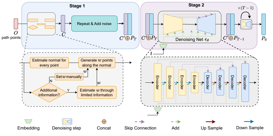
The central object is the Group Diffusion Model (GDM), a point-wise diffusion scheme for large point clouds that treats each map as a collection of local groups rather than one global distribution. For each group $p_i$ it computes a centroid $C_i$, normalizes to $g_i = p_i - C_i$, and runs the standard diffusion-and-denoisng equations in that local frame so the distribution of each group stays close to $\mathcal{N}(0,I)$. This normalization is what keeps the diffusion loss stable for elongated, large-scale maps whose global point distribution deviates sharply from the standard normal. The machinery also includes Stage 1, which creates the central points $C$ from the path by estimating each path point's normal and generating one point per meter up to width $w$, giving the denoiser a conditional scaffold to fill in.
What would settle it
A decisive check is to run the two-stage generator on odometry from a large open plaza or an indoor corridor, compare the output against LiDAR ground truth, and also train on one city and test on a different city without retraining: if the chamfer distance is no better than the input width corridor itself, or if accuracy collapses on the unseen city, the central claim fails.
Extended reading notes
Core claim
On its own terms, the paper claims that map generation can be cast as a denoising problem conditioned on the trajectory: the environment's geometry is recoverable from a band of points around the robot's path. The group diffusion model divides a large map into spatial groups, normalizes each group around its centroid so the point distribution sits near the standard normal, runs the DDPM forward-and-reverse process group-wise, and reassembles the denoised groups. Stage 1 manufactures the noisy input: from path points it estimates normals and lays points at one-per-meter spacing out to a width $w$, and in Mode 3 it estimates that width from only 50 sampled LiDAR points. Stage 2's sparse U-Net denoiser then predicts the noise and recovers the full map, which the authors claim yields reasonable maps from path data alone and more refined maps with exiguous LiDAR data.
Load-bearing premise
The method assumes that a one-point-per-meter ribbon of points around the robot's path, reaching a fixed width into the surroundings, contains enough information for the denoiser to reconstruct the whole map, and that a model trained on one city's streets will work in other places.
Editorial extensions
If this is right
- A robot with only odometry could produce an elementary 3D map of the street type it has seen before, with no LiDAR or camera onboard.
- Adding roughly 50 sparse positioning points per map block would cut generation error by more than a fifth relative to path-only input, so cheap contact or ultrasonic sensors could meaningfully sharpen maps.
- The same trained denoiser works for different trajectory shapes—straight, curved, circular, and square—so the learned map imagination is not tied to road-like paths alone.
- Mapping hardware payload and cost could shrink for robots operating in known environment types, since basic maps no longer require heavy perception stacks.
Reading between the lines
- The paper does not test cross-city generalization; a natural next experiment is training on one city and evaluating on a different city's street data to see whether the width-corridor prior transfers beyond KITTI-360 geometry.
- Because Stage 1 only populates a band of width $w$ around the path, the method implicitly cannot recover geometry far from the trajectory; a useful extension would combine it with exploration policies that choose paths to cover the whole map.
- The group-normalized diffusion idea could generate other large elongated point-cloud data—power lines, pipelines, shorelines—from sparse centerline inputs, not just robot maps.
- The reported improvement from 50 points is measured on block maps sampled from the same LiDAR that defines the ground truth; real ultrasonic or contact-based positioning would test whether the width estimate remains informative outside LiDAR sampling.
Editorial analysis
A structured set of objections, weighed in public.
Referee Report
Summary. The paper proposes a two-stage pipeline for generating large-scale 3D point-cloud maps from a trajectory ('path') alone, optionally supplemented by a small number of sparse LiDAR points. Stage 1 constructs a dense set of 'central points' by placing points one meter apart along the path normal up to a width w. Stage 2 adds Gaussian noise to these central points and applies a learned group-diffusion denoiser to recover a map. The method is trained on KITTI-360 sequence 00 and evaluated on three other KITTI-360 sequences under three modes: path-only with fixed width w=20m (Mode 1), path with random width w in [15,35] (Mode 2), and path plus 50 sample points used to estimate w (Mode 3). Reported Chamfer distance and IoU improve from Mode 1 to Mode 3, supporting the claim that extra sparse observations refine the generated map. The central claim, stated in the abstract and conclusion, is that a robot can generate reasonable maps from path data alone, with further refinement when a few LiDAR points are added.
Significance. The core idea of using a generative model to 'imagine' map structure from bare trajectories is attractive and addresses a real need in robotic mapping under severe sensor constraints. The group-diffusion formulation is a sensible way to scale diffusion to large scenes, and the use of the public KITTI-360 dataset is a strength. The explicit comparison of three input modes is also helpful for understanding the value of additional sparse information. However, the central claim that the denoiser actually imagines environment structure is not yet supported by the experiments: there is no baseline where the Stage-1 corridor is evaluated directly, and the any-shape experiment in Sec. IV-C indicates the model may act as a local noise filter rather than a global map prior. Given these issues, the significance is conditional: if the missing baselines were provided and the method were shown to generalize outside the training city, the contribution would be a useful step toward sensor-light mapping.
major comments (3)
- [Sec. III-C and Table I] The paper's central claim is that Stage 2 diffusion 'imagines' maps from path-only inputs. The only quantitative support is Table I, which compares three modes against each other but never against the raw Stage-1 point set C' defined in Sec. III-C. Since C' already contains points placed every meter along the path normal up to width w, a non-learned baseline outputting C' alone would already cover the route corridor and could score substantial Chamfer distance and IoU. Moreover, the experiment in Sec. IV-C (any shape) shows that the denoiser returns hand-made shapes after noise removal without adding any structural detail, suggesting it behaves as a local denoiser rather than a global map prior. To substantiate the 'map imagination' claim, please report CD/IoU for C' alone (with no added noise and no denoising) and for C' with Gaussian noise added and then removed by a standard non-learned filter (e.g., a Gaussian blur or a simple denoiser). The difference between these baselines and Mode 1/2/3 will isolate the contribution of the learned diffusion model.
- [Sec. IV, Experimental datasets] All reported metrics in Table I come from a single training run and a single inference pass, with no error bars, multiple seeds, or ablations. Furthermore, the model is trained only on KITTI-360 sequence 00 (604 block maps) and tested on three other sequences from the same city. The conclusion that 'robots acquire basic mapping abilities solely with odometry' is a generalization claim, yet no cross-city or out-of-distribution test is provided. Please add multiple-seed statistics and at least one held-out environment type (e.g., a different LiDAR dataset, a recorded scenario in another city, or a synthetic environment with distinct geometry) to assess whether the learned prior transfers beyond the training distribution.
- [Sec. IV-B, Mode 3] In Mode 3, the width w is estimated from 50 points randomly sampled from 'the original map data', which is the same ground-truth map used for evaluation. While w is a scalar statistic rather than the full map, this setup gives the method oracle access to the target map at inference. A realistic 'exiguous positioning data' scenario would provide independent sensor measurements (e.g., points from a separate LiDAR scan, contact sensors, or a prior map from a different session). Please either justify the oracle assumption, estimate w from an independent source, or report sensitivity to the number and spatial distribution of the sampled points.
minor comments (9)
- [Throughout] The manuscript contains numerous typos and grammatical errors (e.g., 'peception', 'equiped', 'memeory', 'oringin', 'Comparason', 'converte', 'signals'). A thorough language revision is needed.
- [Sec. III-B] The sentence 'The distribution of a certain group is close to mean 0 and the identity matrix I as diagonal covariance' is unclear; please specify exactly what normalization is applied to each group before diffusion.
- [Sec. III-B] The method for dividing the point cloud into groups is not described. Please state how groups are formed (e.g., FPS, spatial clustering, or a grid) and whether group size is fixed.
- [Sec. IV, Experimental datasets] The test sequences labeled I, II, and III are not identified. Please specify which KITTI-360 sequences they correspond to and how they differ from the training sequence.
- [Sec. IV-A] Mode 2 is described as using a random width w in [15,35], but Table I gives a single number for each metric. Please clarify whether the reported value is an average over several random widths and report the variance.
- [Sec. IV-A] The claim that Mode 3 improves by 'more than 20%' is ambiguous because it does not specify the metric. For CD, the improvement over Mode 1 is about 31% on sequence I (3.5 to 2.4), while for IoU it is about 8% relative. Please state the metric and the direction of improvement explicitly.
- [Sec. III-B, Eq. (14)] The symbol N in the denominator of the loss in Eq. (13) is not defined; please clarify whether it is the total number of points or the number of groups.
- [Sec. IV-C] The any-shape experiment is described as showing 'ability to generate large maps of different shapes', but it would be more informative to also report quantitative metrics (e.g., CD to the noiseless input shape) so readers can see how much the denoiser alters the input beyond noise removal.
- [Sec. III-C] The regularization weight r=5 and the corridor width w are hand-set hyperparameters, and no sensitivity analysis is provided. Please report at least a small study of how CD/IoU vary with w and r.
Circularity Check
No circular derivation: path and width enter as inputs, the diffusion loss is a supervised noise-prediction loss, and no load-bearing self-citation is used.
full rationale
The derivation chain is self-contained. Stage 1 deterministically constructs central points C' from path points, per-point normals, and a width w (Sec. III-C); Stage 2 applies a standard DDPM denoiser trained with the supervised MSE loss of Eq. (13). Nothing is fitted to the target map and then renamed a prediction: in Mode 3 the width w is estimated from 50 sampled LiDAR points, but that width is an input to the corridor construction, not the predicted map, and the predicted point cloud is produced by the denoiser. The references are to external work (e.g., DDPM [11], Pointcept [34], KITTI-360 [35]) and involve no overlapping authorship, so there is no self-citation chain. The absence of a Stage-1-only baseline (raw corridor C') and the lack of a cross-city test are experimental/completeness concerns about whether the learned denoiser adds map content beyond the corridor, but they are not circularity: the equations do not reduce the output to the input by construction. Hence no circular step is identified.
Assumptions & free parameters
free parameters (2)
- Corridor width w =
20 m (Mode 1); random in [15, 35] m (Mode 2); estimated from 50 LiDAR points (Mode 3)
- Regularization weight r =
5
assumptions (4)
- standard math Diffusion process assumptions from DDPM (Markov chain, Gaussian noise, known beta schedule) hold for grouped point clouds.
- domain assumption Odometry or path data is available and accurate enough to define the map corridor.
- domain assumption The learned map prior from KITTI-360 sequence 00 generalizes to other sequences and environments.
- ad hoc to paper A corridor of width w around the trajectory is a sufficient condition for the denoiser to reconstruct the environment.
Cite this review
Pith. "Pith review of Map Imagination Like Blind Humans: Group Diffusion Model for Robotic Map Generation." pith.science (2026). https://pith.science/paper/JV3NOQKI
@misc{pith2026241216908,
  author       = {Pith},
  title        = {Pith review of: Map Imagination Like Blind Humans: Group Diffusion Model for Robotic Map Generation},
  year         = {2026},
  howpublished = {\url{https://pith.science/paper/JV3NOQKI}},
  note         = {Machine review of arXiv:2412.16908}
}
read the original abstract
Can robots imagine or generate maps like humans do, especially when only limited information can be perceived like blind people? To address this challenging task, we propose a novel group diffusion model (GDM) based architecture for robots to generate point cloud maps with very limited input information.Inspired from the blind humans' natural capability of imagining or generating mental maps, the proposed method can generate maps without visual perception data or depth data. With additional limited super-sparse spatial positioning data, like the extra contact-based positioning information the blind individuals can obtain, the map generation quality can be improved even more.Experiments on public datasets are conducted, and the results indicate that our method can generate reasonable maps solely based on path data, and produce even more refined maps upon incorporating exiguous LiDAR data.Compared to conventional mapping approaches, our novel method significantly mitigates sensor dependency, enabling the robots to imagine and generate elementary maps without heavy onboard sensory devices.
Figures


Figures from the paper (3 more)


Reference graph
Works this paper leans on
-
[1]
Loam: Lidar odometry and mapping in real-time
J. Zhang, S. Singh et al. , “Loam: Lidar odometry and mapping in real-time.” in Robotics: Science and systems , vol. 2, no. 9. Berkeley, CA, 2014, pp. 1–9
work page 2014
-
[2]
P-slam: Simultaneous localization and mapping with environmental-structure prediction,
H. J. Chang, C. G. Lee, Y .-H. Lu, and Y . C. Hu, “P-slam: Simultaneous localization and mapping with environmental-structure prediction,” IEEE Transactions on Robotics , vol. 23, no. 2, pp. 281–293, 2007
work page 2007
-
[3]
Orb-slam3: An accurate open-source library for visual, visual–inertial, and multimap slam,
C. Campos, R. Elvira, J. J. G. Rodr ´ıguez, J. M. Montiel, and J. D. Tard ´os, “Orb-slam3: An accurate open-source library for visual, visual–inertial, and multimap slam,” IEEE Transactions on Robotics , vol. 37, no. 6, pp. 1874–1890, 2021
2021
-
[4]
Vins-mono: A robust and versatile monoc- ular visual-inertial state estimator,
T. Qin, P. Li, and S. Shen, “Vins-mono: A robust and versatile monoc- ular visual-inertial state estimator,” IEEE transactions on robotics , vol. 34, no. 4, pp. 1004–1020, 2018
2018
-
[5]
Scaling diffusion models to real-world 3d lidar scene completion,
L. Nunes, R. Marcuzzi, B. Mersch, J. Behley, and C. Stachniss, “Scaling diffusion models to real-world 3d lidar scene completion,” in Proceedings of the IEEE/CVF Conference on Computer Vision and Pattern Recognition, 2024, pp. 14 770–14 780
work page 2024
-
[6]
Scalable, distributed, real-time map generation,
J. J. Davies, A. R. Beresford, and A. Hopper, “Scalable, distributed, real-time map generation,” IEEE Pervasive Computing , vol. 5, no. 4, pp. 47–54, 2006
work page 2006
-
[7]
L. Yang, J. Wei, Z. Zuo, and S. Zhou, “Mac-gan: A community road generation model combining building footprints and pedestrian trajectories,” ISPRS International Journal of Geo-Information , vol. 12, no. 5, p. 181, 2023
work page 2023
-
[8]
Learning 3d dense correspondence via canonical point autoencoder,
A.-C. Cheng, X. Li, M. Sun, M.-H. Yang, and S. Liu, “Learning 3d dense correspondence via canonical point autoencoder,” Advances in Neural Information Processing Systems, vol. 34, pp. 6608–6620, 2021
work page 2021
Show all 36 references
-
[9]
Diffusion probabilistic models for scene-scale 3d categorical data,
J. Lee, W. Im, S. Lee, and S.-E. Yoon, “Diffusion probabilistic models for scene-scale 3d categorical data,” arXiv preprint arXiv:2301.00527 , 2023
2023 arXiv
-
[10]
Vg-vae: a venatus geometry point-cloud variational auto-encoder,
T. Anvekar, R. A. Tabib, D. Hegde, and U. Mudengudi, “Vg-vae: a venatus geometry point-cloud variational auto-encoder,” in Proceed- ings of the IEEE/CVF conference on computer vision and pattern recognition, 2022, pp. 2978–2985
2022
-
[11]
Denoising diffusion probabilistic models,
J. Ho, A. Jain, and P. Abbeel, “Denoising diffusion probabilistic models,” Advances in neural information processing systems , vol. 33, pp. 6840–6851, 2020
2020
-
[12]
Denoising diffusion implicit models,
J. Song, C. Meng, and S. Ermon, “Denoising diffusion implicit models,” arXiv preprint arXiv:2010.02502 , 2020
2010 arXiv
-
[13]
High-resolution image synthesis with latent diffusion models,
R. Rombach, A. Blattmann, D. Lorenz, P. Esser, and B. Ommer, “High-resolution image synthesis with latent diffusion models,” in Proceedings of the IEEE/CVF conference on computer vision and pattern recognition, 2022, pp. 10 684–10 695
2022
-
[14]
Towards realistic scene gener- ation with lidar diffusion models,
H. Ran, V . Guizilini, and Y . Wang, “Towards realistic scene gener- ation with lidar diffusion models,” in Proceedings of the IEEE/CVF Conference on Computer Vision and Pattern Recognition , 2024, pp. 14 738–14 748
2024
-
[15]
Fast lidar upsampling using conditional diffusion models,
S. E. M. Helgesen, K. Nakashima, J. Tørresen, and R. Kurazume, “Fast lidar upsampling using conditional diffusion models,” arXiv preprint arXiv:2405.04889, 2024
2024 arXiv
-
[16]
Pyramid diffusion for fine 3d large scene generation,
Y . Liu, X. Li, X. Li, L. Qi, C. Li, and M.-H. Yang, “Pyramid diffusion for fine 3d large scene generation,” 2024
2024
-
[17]
Completing robot maps by predicting the layout of rooms behind closed doors,
M. Luperto, F. Amadelli, and F. Amigoni, “Completing robot maps by predicting the layout of rooms behind closed doors,” in 2021 European Conference on Mobile Robots (ECMR) . IEEE, 2021, pp. 1–7
2021
-
[18]
Learned map prediction for enhanced mobile robot exploration,
R. Shrestha, F.-P. Tian, W. Feng, P. Tan, and R. Vaughan, “Learned map prediction for enhanced mobile robot exploration,” in 2019 International Conference on Robotics and Automation (ICRA) . IEEE, 2019, pp. 1197–1204
2019
-
[19]
Uncertainty-aware occupancy map prediction using generative net- works for robot navigation,
K. Katyal, K. Popek, C. Paxton, P. Burlina, and G. D. Hager, “Uncertainty-aware occupancy map prediction using generative net- works for robot navigation,” in 2019 International Conference on Robotics and Automation (ICRA) . IEEE, 2019, pp. 5453–5459
2019
-
[20]
High-speed robot navigation using predicted occupancy maps,
K. D. Katyal, A. Polevoy, J. Moore, C. Knuth, and K. M. Popek, “High-speed robot navigation using predicted occupancy maps,” in 2021 IEEE International Conference on Robotics and Automation (ICRA). IEEE, 2021, pp. 5476–5482
2021
-
[21]
Pre-trained masked image model for mobile robot navigation,
V . D. Sharma, A. Singh, and P. Tokekar, “Pre-trained masked image model for mobile robot navigation,” in 2024 IEEE International Conference on Robotics and Automation (ICRA) . IEEE, 2024, pp. 5126–5133
2024
-
[22]
Improved denoising diffusion prob- abilistic models,
A. Q. Nichol and P. Dhariwal, “Improved denoising diffusion prob- abilistic models,” in International conference on machine learning . PMLR, 2021, pp. 8162–8171
2021
-
[23]
Text2video-zero: Text-to-image diffu- sion models are zero-shot video generators,
L. Khachatryan, A. Movsisyan, V . Tadevosyan, R. Henschel, Z. Wang, S. Navasardyan, and H. Shi, “Text2video-zero: Text-to-image diffu- sion models are zero-shot video generators,” in Proceedings of the IEEE/CVF International Conference on Computer Vision , 2023, pp. 15 954–15 964
2023
-
[24]
Rich human feedback for text- to-image generation,
Y . Liang, J. He, G. Li, P. Li, A. Klimovskiy, N. Carolan, J. Sun, J. Pont-Tuset, S. Young, F. Yanget al., “Rich human feedback for text- to-image generation,” in Proceedings of the IEEE/CVF Conference on Computer Vision and Pattern Recognition , 2024, pp. 19 401–19 411
2024
-
[25]
Instancediffusion: Instance-level control for image generation,
X. Wang, T. Darrell, S. S. Rambhatla, R. Girdhar, and I. Misra, “Instancediffusion: Instance-level control for image generation,” in Proceedings of the IEEE/CVF Conference on Computer Vision and Pattern Recognition, 2024, pp. 6232–6242
2024
-
[26]
Generative adversarial net- works,
I. Goodfellow, J. Pouget-Abadie, M. Mirza, B. Xu, D. Warde-Farley, S. Ozair, A. Courville, and Y . Bengio, “Generative adversarial net- works,” Communications of the ACM , vol. 63, no. 11, pp. 139–144, 2020
2020
-
[27]
Deepcache: Accelerating diffusion models for free,
X. Ma, G. Fang, and X. Wang, “Deepcache: Accelerating diffusion models for free,” in Proceedings of the IEEE/CVF Conference on Computer Vision and Pattern Recognition , 2024, pp. 15 762–15 772
2024
-
[28]
Adding conditional control to text-to-image diffusion models,
L. Zhang, A. Rao, and M. Agrawala, “Adding conditional control to text-to-image diffusion models,” in Proceedings of the IEEE/CVF International Conference on Computer Vision , 2023, pp. 3836–3847
2023
-
[29]
Freecontrol: Training-free spatial control of any text-to-image dif- fusion model with any condition,
S. Mo, F. Mu, K. H. Lin, Y . Liu, B. Guan, Y . Li, and B. Zhou, “Freecontrol: Training-free spatial control of any text-to-image dif- fusion model with any condition,” in Proceedings of the IEEE/CVF Conference on Computer Vision and Pattern Recognition , 2024, pp. 7465–7475
2024
-
[30]
Learning to generate realistic lidar point clouds,
V . Zyrianov, X. Zhu, and S. Wang, “Learning to generate realistic lidar point clouds,” in European Conference on Computer Vision. Springer, 2022, pp. 17–35
2022
-
[31]
Diffusion probabilistic models for 3d point cloud generation,
S. Luo and W. Hu, “Diffusion probabilistic models for 3d point cloud generation,” in Proceedings of the IEEE/CVF conference on computer vision and pattern recognition , 2021, pp. 2837–2845
2021
-
[32]
Lion: Latent point diffusion models for 3d shape generation,
A. Vahdat, F. Williams, Z. Gojcic, O. Litany, S. Fidler, K. Kreis et al. , “Lion: Latent point diffusion models for 3d shape generation,” Advances in Neural Information Processing Systems , vol. 35, pp. 10 021–10 039, 2022
2022
-
[33]
Pyramid diffusion for fine 3d large scene generation,
Y . Liu, X. Li, X. Li, L. Qi, C. Li, and M.-H. Yang, “Pyramid diffusion for fine 3d large scene generation,” arXiv preprint arXiv:2311.12085 , 2023
2023 arXiv
-
[34]
Pointcept: A codebase for point cloud perception research,
P. Contributors, “Pointcept: A codebase for point cloud perception research,” https://github.com/Pointcept/Pointcept, 2023
2023
-
[35]
Kitti-360: A novel dataset and benchmarks for urban scene understanding in 2d and 3d,
Y . Liao, J. Xie, and A. Geiger, “Kitti-360: A novel dataset and benchmarks for urban scene understanding in 2d and 3d,” IEEE Transactions on Pattern Analysis and Machine Intelligence , vol. 45, no. 3, pp. 3292–3310, 2022
2022
-
[36]
Pointnet++: Deep hierarchical feature learning on point sets in a metric space,
C. R. Qi, L. Yi, H. Su, and L. J. Guibas, “Pointnet++: Deep hierarchical feature learning on point sets in a metric space,” Advances in neural information processing systems , vol. 30, 2017
2017
Reviewed August 11, 2026 · model on record in the stance chip above.
Discussion (0). Continue with ORCID to comment.